Stonehenge
World Heritage Site
Management Plan 2009
Stonehenge is the focus of a complex of prehistoric monuments and sites
Cover
Stonehenge and its surroundings
Sky Eye aerial photography 2004 © English Heritage Photo Library K040312
The Vision for Stonehenge
The Stonehenge World Heritage Site is globally important not just for
Stonehenge, but for its unique and dense concentration of outstanding
prehistoric monuments and sites, which together form a landscape
without parallel. We will care for and safeguard this special area and
its archaeology and will provide a more tranquil, biodiverse and rural
setting for it, allowing present and future generations to enjoy it and the
landscape more fully. We will also ensure that its special qualities are
presented, interpreted and enhanced where necessary, so that visitors
can better understand the extraordinary achievements of the prehistoric
peoples who left us this rich legacy.
Stonehenge
World Heritage Site
Management Plan 2009
Written and compiled by
Christopher Young, Amanda Chadburn and Isabelle Bedu
Published in January 2009 by English Heritage
on behalf of the Stonehenge World Heritage Site Committee
© English Heritage 2009
English Heritage, 1 Waterhouse Square, 138–142 Holborn, London EC1N 2ST
CONTENTS
Page
FOREWORD 6
PREFACE 7
ACKNOWLEDGEMENTS 8
PART 1: THE MANAGEMENT PLAN AND THE SIGNIFICANCE OF
THE STONEHENGE WORLD HERITAGE SITE 9
1.0 Function of the World Heritage Site Management Plan 11
1.1 The need for the Plan 11
1.2 The status of the Plan 12
1.3 The purpose of the Plan 12
1.4 The structure of the Plan 13
1.5 The process of developing the Plan 13
1.6 Data Sources 15
2.0 Assessment of the 2000 World Heritage Site Management Plan 15
2.1 Evaluation of the 2000 Management Plan 15
2.2 Public Inquiries and Government decisions affecting the 2000 Vision for the WHS 18
2.3 Changes in knowledge since 2000 19
2.4 The “core zone” of the 2000 Management Plan 20
3.0 Description and significance of the World Heritage Site 20
3.1 Location and boundary of the Stonehenge part of the WHS 20
Location 20
The Stonehenge WHS and its boundary 20
3.2 Description of the World Heritage Site 21
Brief description 21
The cultural heritage of the World Heritage Site 21
The character of the WHS and its regional context 23
3.3 Significance of the World Heritage Site 25
The Outstanding Universal Value of the WHS 25
Statement of Significance 25
Attributes of Outstanding Universal Value for the Stonehenge part of the WHS 28
Authenticity and Integrity 32
Other cultural heritage and historic environment values 34
Landscape and nature conservation values 34
Educational and research values 36
Social, artistic and spiritual values 36
Tourism and economic values 37
2 StonehengeWorld Heritage Site Management Plan 2009 Contents
Page
4.0 Current policy context 37
4.1 Planning and policy framework 37
4.2 Relationship to other statutory and management plans 38
4.3 Historic environment designations 39
4.4 Landscape and nature conservation designations 40
4.5 Government position on road and visitor centre 40
5.0 Current management context 41
5.1 The Stonehenge WHS executive and consultative groups 41
5.2 The Stonehenge WHS team 41
5.3 Working groups and liaison with key partners 41
5.4 Funding arrangements for the WHS team 41
5.5 Relationship to the Avebury part of the WHS 42
5.6 Ownership and management roles 43
5.7 The role of English Heritage 43
5.8 The role of the National Trust 44
5.9 The local community 44
5.10 Agriculture 44
5.11 Agri-environmental schemes 45
5.12 The military 46
5.13 Woodland and forestry management 47
5.14 Royal Society for the Protection of Birds 47
5.15 Museums 47
5.16 The Geographic Information System database 47
PART 2: KEY MANAGEMENT ISSUES 49
6.0 Introduction to key issues 50
7.0 Planning and policy 52
7.1 UNESCO Policies and Guidance 52
7.2 Changes to the English planning system 54
7.3 Heritage Protection Reform 55
7.4 English Heritage’s Conservation Principles 57
7.5 Government statements affecting Stonehenge 57
7.6 The WHS boundary and buffer zone 57
7.7 Development control 59
8.0 Conservation 60
8.1 The condition of archaeological monuments and sites in the WHS 60
8.2 The settings of the WHS and its attributes of OUV 62
8.3 Monument management 64
8.4 Agricultural practices 65
8.5 Conservation of other parts of the historic environment 66
8.6 Nature conservation 66
8.7 Climate change 70
8.8 Risk management and counter-disaster preparedness 70
StonehengeWorld Heritage Site Management Plan 2009 3
Page
9.0 Visitor, tourism and education issues 71
9.1 Sustainable tourism 71
9.2 Public access 74
9.3 Visitor management 75
9.4 Solstice management 77
9.5 Physical impacts on the Site 78
9.6 Existing visitor facilities 78
9.7 The need for improved visitor facilities 79
9.8 Interpretation, education and museums 79
10.0 Roads and traffic 81
10.1 Highways network and usage 81
10.2 Road safety 83
10.3 Public transport provision and sustainable access 83
10.4 Car parking facilities and usage 84
11.0 Research 85
11.1 The importance of research in the WHS 85
11.2 The archaeological research framework 85
11.3 Archaeological research priorities 85
11.4 Sustainable archaeological research 86
11.5 The archiving of archaeological finds, paper archives and data 87
11.6 Research links with Avebury and beyond 87
12.0 Maintaining the long-term objectives of the Management Plan 88
13.0 Management, liaison and monitoring arrangements for the World Heritage Site 88
13.1 Management and liaison within the WHS 88
13.2 Revision of WHS governance 90
13.3 Funding and Resources 90
13.4 Relationship to the Avebury WHS 91
13.5 Monitoring and reviewing the Plan 92
13.6 Monitoring indicators 92
PART 3: AIMS AND POLICIES 97
14.0 Vision, aims and policies 99
14.1 Vision 99
14.2 Statutory and Policy Framework 100
14.3 The designation and boundaries of the World Heritage Siten 101
14.4 Conservation of the World Heritage Site 102
14.5 Sustainable Tourism and Visitor Management 107
14.6 Sustainable Traffic Management and Transportation 111
14.7 Research 113
14.8 Long-term objectives for the World Heritage Site 114
14.9 Management, Liaison and Monitoring 114
4 StonehengeWorld Heritage Site Management Plan 2009 Contents
Page
PART 4: IMPLEMENTING THE PLAN 117
15.0 Action Plan 118
BIBLIOGRAPHY 133
APPENDICES 137
A. Membership and terms of reference of the Stonehenge WHS Committee 139
B. Membership and terms of reference of the Stonehenge WHS Advisory Forum 141
C. The WHS Management Plan public consultation process 142
D. Statement of principles governing archaeological work in the Stonehenge WHS 145
E. The role of the WHS Coordinator 148
F. Reports and Decisions from the World Heritage Committee and Bureau referring to Stonehenge 149
G. Detailed archaeological description of the Stonehenge World Heritage Site 155
H. Stonehenge Regulations 1997 158
I. Key publications, surveys and education resources 160
J. MOD and MPBW Concordat on Future Building Work at Larkhill 164
K. ICOMOS International Cultural Tourism Charter 166
L. Bodies with an interest in the WHS 167
M. The English Heritage Stonehenge GIS 168
N. Article 4 Direction in relation to land around Stonehenge 169
O. Regional, sub-regional and local planning policies of relevance to Stonehenge 170
P. The “Vision for the Future” extract from the Stonehenge WHS Management Plan 2000 172
MAPS 173
1. The Stonehenge World Heritage Site 175
2. Archaeology and Land Use 176
3. Grass Restoration since 2000 177
4. Access 178
5. Land Ownership 179
6. Heritage Designations 180
7. Landscape and Nature Conservation Designations 181
8. Regional Landscape Context 182
9. Landscape Character 183
10. Visual Sensitivity 184
FACTS AND FIGURES 187
DEFINITIONS 188
ABBREVIATIONS 193
INDEX 194
ILLUSTRATIONS AND TABLES
1. The Aims which should be prioritised during the lifetime of the Plan according to the
Consultation exercise 15
2. Location of the Stonehenge and Avebury WHS in the UK 20
3. Location of the Stonehenge and Avebury WHS in southern England 20
4. Number of collisions and casualties in the WHS between March 2005 and April 2008 83
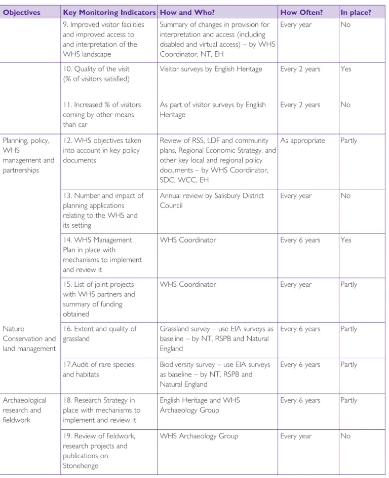
5. Key monitoring indicators for the Stonehenge WHS 94
6. The Stonehenge WHS Action Plan 119
7. Larkhill Concordat map 165
StonehengeWorld Heritage Site Management Plan 2009 5
I am pleased to present this revised Management Plan for the Stonehenge World Heritage Site.
Management Plans are the frameworks in which our World Heritage Sites work to ensure their continued sustainable use and the maintenance of their Outstanding Universal Value for generations to come.They are fundamental to meeting our international obligations under the World Heritage
Convention.
Stonehenge, Avebury and Associated Sites is one of Britain’s best known World Heritage Sites. It is internationally recognised for its outstanding prehistoric monuments. Stonehenge was one of the first sites to have a World Heritage Site Management Plan.This set out a vision for its future protection and presentation; and has enabled substantial improvements to be made to the Site, most notably the creation of large areas of permanent grassland.
This new Management Plan is being introduced at a key point in the development of Stonehenge. It provides the strategic framework for environmental improvements, including the closure of the junction of the A303 and A344 and the re-location and upgrading of the current visitor facilities. It also provides the overall policy framework for the integrated management of the whole World Heritage Site and will guide those with a particular interest in its care. The Plan demonstrates the Government’s commitment to protect and enhance this unique and important Site. We are committed to its implementation and will continue to work closely with our many partners to achieve this goal.The Government is determined to make the necessary road changes, improve the visitor facilities and interpretation by 2012 and strengthen the partnerships in place to help manage the Stonehenge World Heritage Site.
I am extremely grateful to all those who have worked so hard in the last decade to bring about positive change at Stonehenge, in particular English Heritage, the National Trust, the Highways Agency, Natural England, the RSPB, the Ministry of Defence, Wiltshire County Council, Salisbury District Council, the World Heritage Site landowners and all the members of the Stonehenge World Heritage Site Committee and Advisory Forum. I am sure that this document will prove invaluable for the conservation, preservation and protection of this iconic site.
6 StonehengeWorld Heritage Site Management Plan 2009
FOREWORD
PREFACE
The Stonehenge World Heritage Site Management Plan sets out the strategy for the protection of the site for present and future generations. It is about Stonehenge but also about the many outstanding prehistoric monuments which are within the 2,600 hectare World Heritage Site (WHS). Its primary aim is the protection of the archaeological landscape but it also addresses other issues such as access, interpretation, farming, nature conservation, research, education and the local community.The Management Plan explains the international significance of the site, outlines the key management issues, and provides long-term aims and detailed policies. It also includes a detailed action plan identifying the organisations responsible for delivery and a timescale for each action.
The Management Plan was prepared on behalf of the Stonehenge WHS Committee by English Heritage, with extensive involvement of stakeholders and a public
consultation. During 2008, several workshops were held with the WHS Advisory Forum before the Committee discussed each new development of the text. As the chairman of these groups, I can confirm that there was a healthy level of debate and that many amendments were made to the Plan to reflect the comments received. There was also a very good level of response from the three-month public consultation held between July and September, which included an exhibition, a questionnaire, a website and a mailing to local residents. As a result, the new Management Plan is as inclusive as it can be. I hope that it will be endorsed as soon as possible by all those with responsibilities within the World Heritage Site.
Any work of this kind involves a large number of people and organisations.We are grateful to all those consulted for their help and support. I should like particularly to thank the members of the Committee and of the Advisory Forum for their great commitment of time and effort over the very short time available to develop this Plan. On behalf of them all, I would like to express our gratitude to the writers of the Plan for their outstanding achievement.
Elizabeth Gass Chairman
Stonehenge World Heritage Site Committee
ACKNOWLEDGEMENTS
In December 2007, Margaret Hodge, the Culture Minister, asked for the rapid revision of the Stonehenge World Heritage Site Management Plan.That task is the responsibility of the Stonehenge World Heritage Site Committee, made up of bodies and individuals with management or statutory responsibilities in the World Heritage Site (WHS). English Heritage was asked to facilitate the Committee’s work to produce the Plan.
As the principal authors of the Plan, we would like to thank all those who have helped and supported us in what is essentially a team effort to develop a consensus on the future direction of the World Heritage Site. Our first
thanks must go to the Committee itself and also to members of the Advisory Forum, the wider stakeholder body for the World Heritage Site. In particular, we thank most warmly Lady Gass who chaired all eight meetings of the Committee and Advisory Forum as well as leading us on a site visit and taking part in the launch of the public consultation. We would also like to thank Hilary Barnett of Blue Onion who was a very efficient facilitator for the meetings of the Advisory Forum.
The members of the WHS Committee and Advisory Forum who have assisted over 2008 are Roger Fisher (Amesbury Town Council), Philip Miles (Country Land and Business Association), Nigel de Foubert (Ministry of Defence), Peter Marsden and Caity Marsh (DCMS), Dave Healing
(Durrington Parish Council), Peter Carson (English Heritage), Stephanie Payne (Natural England), Chris Jones (Highways Agency), Susan Denyer (ICOMOS UK), Richard Crook (NFU), Chris Gingell, Lucy Evershed, Mike Keen and Nick Kendall-Carpenter (National Trust),Tracé Williams and Tony Richardson (RSPB), Dave Milton (Salisbury District Council), Peter Bailey (Wilsford-cum-lake Parish Council/Landowner), Helena Cave-Penney, Melanie Pomeroy-Kellinger and Tim Jones (Wiltshire County Council), Sarah Simmonds (Avebury WHS Officer), Max Hosier (Boreland Farm), Francis Taylor and Julian Richards (CBA - Wessex), Kate Fielden (CPRE Wiltshire), Peter Goodhugh (Countess Road Residents Association), Richard Osgood (Defence Estates), Ian
Briscoe(Forestry Commission), Robert Turner (Manor Farm), Adrian Green (Salisbury and South Wiltshire Museum), Alistair Millington and Adrian Roper (Sustrans), Sue Davies and Andrew Fitzpatrick (Wessex Archaeology), Brian Davison (WANHS), Bill Haley and Steve Colwill (Wiltshire
Constabulary). We are grateful to all of them for their help and comments.
We were also helped by many colleagues in English Heritage, particularly Gillian Cochrane, who dealt with picture
research, editing and proof-reading; Rachel Foster, who helped with the production of the maps, project
management, GIS issues and editing; and Matthew Reynolds, who assisted with GIS issues and who produced most of the maps. Nick Hanks helped with NMR searches. Other colleagues commented on various drafts, particularly Rohan Torkilsden, Isla Macneal, Martin Harvey, Emma Carver, and Sue Cole, and the English Heritage Advisory Committee also saw drafts and made some comments. Robin Taylor, Neil Collins and Tanya Reid helped with publication, print and design issues.
Other comments and advice were received from Lucy Bradley, Penny Needham, Stuart Maughan, Renee Fok , Mike Harlow and Dave Batchelor (English Heritage), Phil Sheldrake and Peter Exley (RSPB),Tim Darvill (University of
Bournemouth), David Thackray (National Trust), Amanda Riddle (Graylings), Mike Parker-Pearson (University of Sheffield) and David Dawson (WANHS).There were 304 written responses to the Management Plan consultation, and further details are set out in Appendix C of the Plan. Graylings Global were commissioned to run the consultation process and some of their report has been included in this Plan. We were in the fortunate position that a Plan already existed, and some of the information and text from the 2000 Plan, written by Chris Blandford Associates (which itself drew on the 1998 Avebury WHS Management Plan), has found its way into this one. We would also like to thank Rowan Whimster of Whimster Associates, who edited the draft Plan during the Autumn, Alan Rutter, who prepared the index, and all the team at FONDA and Colourhouse, who have worked so hard to meet our very tight deadlines.
We are extremely grateful to all these people who have assisted in the production of this Plan.
Christopher Young Amanda Chadburn Isabelle Bedu English Heritage
Part 1
The Management Plan and
the significance of the
Stonehenge World Heritage Site
Stonehenge at dawn
James O Davies 2007 © English Heritage Photo Library N071271
Part 1
The Management Plan and
the significance of the
Stonehenge World Heritage Site
Stonehenge at dawn
10 StonehengeWorld Heritage Site Management Plan 2009
Part 1 – The Management Plan and the significance of the Stonehenge World Heritage Site
The Stonehenge, Avebury and Associated Sites World Heritage Site was inscribed in 1986. It is in two parts, some 27 km apart, focused respectively on the great stone circles of Stonehenge and Avebury.
Stonehenge is among the most iconic and best known internationally of archaeological sites. The Stonehenge part of the World Heritage Site (WHS) covers 2,600 hectares around Stonehenge itself, and comprises one of the richest concentrations of early prehistoric monuments in the world. Stonehenge monument itself attracts around 900,000 visitors each year, but the WHS is also a place where people live and work and much of it is farmed. Managing the various interests and concerns affecting the Site to protect and enhance its Outstanding Universal Value (OUV) is complex and challenging.
This Management Plan sets the overarching strategy for achieving the correct balance between conservation, access, the interests of the local community and the sustainable use of the site, whether for recreation and tourism, or for agriculture. The strategy aims to protect the Site for its OUV as agreed by UNESCO, provide access worthy of the site for visitors, and allow its continued use for sustainable agriculture. Central to it is the Vision established for the 2000 Plan, the essence of which is still valid today (see Appendix P for the full text of 2000 Vision for reference purposes).
The Vision for the Stonehenge
World Heritage Site
The Stonehenge WHS is globally important not just for Stonehenge, but for its unique and dense concentration of outstanding prehistoric monuments and sites, which together form a landscape without parallel. We will care for and safeguard this special area and its archaeology and will provide a more tranquil, biodiverse and rural setting for it, allowing present and future generations to enjoy it and the landscape more fully. We will also ensure that its special qualities are presented, interpreted and enhanced where necessary, so that visitors can better understand the extraordinary achievements of the prehistoric peoples who left us this rich legacy.
Priorities for 2009-2015
The primary purpose of this Management Plan is to guide all interested parties on the care of this World Heritage Site by sustaining its Outstanding Universal Value. This will ensure the effective protection, conservation, and presentation of the World Heritage Site for present and future generations. It will also ensure that all decisions affecting the World Heritage Site move towards the achievement of the Vision.
The priorities of this Management Plan are to:
■ maintain and extend permanent grassland to protect buried archaeology from ploughing and to provide an appropriate setting for upstanding monuments;
■ remove the woodland and scrub cover from key monuments;
■ remove or screen inappropriate structures or roads, in particular the A344, and keep the A303
improvements under review;
■ enhance the visitor experience by 2012 by providing improved interim facilities;
■ improve the interpretation of the WHS and increase access to selected monuments;
■ continue to encourage sustainable archaeological research and education to improve and transmit our understanding of the WHS;
■ encourage the sustainable management of the WHS, balancing its needs with those of farming, nature conservation, access, landowners and the local community.
Traffic on the A303
Part 1
The Management Plan and the significance of the
Stonehenge World Heritage Site
Introduction
James O
StonehengeWorld Heritage Site Management Plan 2009 11
Part 1 – The Management Plan and the significance of the Stonehenge World Heritage Site
1.0
FUNCTION OF THE WORLD
HERITAGE SITE MANAGEMENT
PLAN
1.1
The need for the Plan
1.1.1 World Heritage Sites are recognised as places of OUV under the terms of the 1972 UNESCO Convention concerning the Protection of the World Cultural and Natural Heritage (the World Heritage Convention). By joining the Convention, the United Kingdom Government has undertaken to identify, protect, conserve, present and transmit such Sites to future generations (UNESCO 1972, Article 4). It is for each Government to decide how to fulfil these commitments. In England, this is done through the statutory spatial planning system, designation of specific assets, and the development of WHS Management Plans.
1.1.2 The Operational Guidelines for the Implementation of the World Heritage Convention(2008) say:
“each nominated property should have an appropriate management plan or other management system which should specify how the OUV of a World Heritage Site should be preserved, preferably through
participatory mean.
The purpose of such a management system is to ensure the effective protection of the site for present and future generations (paras 108-109).”
Since 1994 it has been UK Government policy that all UK World Heritage Sites should have
Management Plans.
1.1.3 The recently published draft planning circular on World Heritage together with its supporting guidance (May 2008) emphasise the need for comprehensive management plans based on a proper understanding of the OUV of the site. Such plans need to be developed in a consensual way, fully involving all interested parties including those responsible for managing, owning or administering the particular World Heritage Site.
1.1.4 All effective conservation is concerned with the successful management of change. Conserving the Site is fundamental but some change is inevitable if the Site is to respond to the needs of present-day society. Effective management of a WHS is therefore
concerned with identification and promotion of change that will respect, conserve and enhance the Site and its OUV, and with the avoidance,
modification or mitigation of changes that might damage them. It is also necessary to develop policies for the sustainable use of the site for the benefit of the local population and economy.
The first phase of Stonehenge is the circular earthwork (c. 3000 BC) which is clearly visible on this early morning shot
12 StonehengeWorld Heritage Site Management Plan 2009
Part 1 – The Management Plan and the significance of the Stonehenge World Heritage Site 1.1.5 It is essential that all change is carefully planned and
that competing uses are reconciled without compromising the overriding commitment to conserve the Site. WHS Management Plans are intended to resolve such potential conflicts and to achieve the appropriate balance between conservation, access and interpretation, the interests of the local community, and sustainable economic use of the Site. They must also be capable of being implemented within the means available to achieve this.
1.1.6 The first Stonehenge WHS Management Planwas completed in 2000 (English Heritage, 2000a). It provided the opportunity to develop policies to deal with the various problems affecting Stonehenge. Those identified in the Plan included the impact of large numbers of visitors, and also the impacts of traffic on the A303, and on the A344 which severs Stonehenge from its Avenue a few metres from the Heel Stone. The visual and noise pollution of the roads had long been recognised as significant detractors from the setting of the Stones. Post-war agricultural intensification, changes in military use of the areas around the WHS and at Larkhill, and increasing demands for leisure and recreational use of the countryside, have all contributed to changes in the character and quality of the WHS landscape.
1.1.7 Much has been achieved to fulfil the objectives of the 2000 Plan (see 2.1 below). Equally, some major objectives have not been achieved. Periodic review of WHS Management Plans is recommended as best practice and was delayed in this case until key decisions on the roads and visitor facilities had been taken. Now that this has happened, the Government has asked for a revision of the Plan to be carried out as soon as possible to provide the policy framework for future management of the WHS.
1.2
The status of the Plan
1.2.1 Within the UK, WHS Management Plans are
recommended in Government planning guidance and so are a material consideration in planning decisions. The 2000 Management Plan has been adopted as Supplementary Planning Guidance (SPG) by Salisbury District Council. Management Plans provide an advisory policy framework for guiding and influencing planned or potential management initiatives at a variety of scales and for different purposes. They depend for their effectiveness on consensus among the key stakeholders involved in the WHS and willingness on their part to work in partnership towards the achievement of the agreed objectives in
these Plans. Once endorsed by the Department for Culture, Media and Sport, Management Plans are referred to UNESCO who forward them to the International Council on Monuments and Sites (ICOMOS) for review.
1.2.2 The Management Plan brings together the policies and aspirations of a number of different bodies involved with the WHS. At the same time, it sets out a management framework for the WHS. Individual stakeholders should use the Plan to influence their own strategic and action plans as these are reviewed and implemented over the life of this Management Plan. The Government has confirmed that the Management Plan will remain the overarching strategic document for the WHS.
1.3
The purpose of the Plan
1.3.1 The primary purpose of the Management Plan is to sustain the Outstanding Universal Value of the WHS to ensure the effective protection, conservation, presentation and transmission of the WHS to present and future generations. The significance and value of the WHS is discussed further in section 3, but it is the OUV of the Site which makes it important in global terms for all humanity, and which is therefore the main focus of and reason for the Plan. To sustain the OUV, it is necessary to manage all the attributes of OUV. Additionally, there are also a number of other aspects and values of the Site (such as ecological value) which need managing and/or improving: these are discussed in sections 3.3.24-3.3.45 below. ‘Conservation’ in the context of this Plan includes not only ensuring the physical survival of the
archaeological sites and monuments and/or the improvement of their condition, but also enhancing the visual character of their landscape setting, increasing biodiversity and improving the
interpretation and understanding of the WHS as a landscape without parallel. Continued research into all aspects of the WHS will be fundamental to informing its appropriate future management.
1.3.2 In order to achieve the primary aim of protecting the WHS through the conservation of its OUV, this Plan provides an integrated approach to managing the WHS, where the needs of various stakeholders and of conserving elements of the WHS that have different values are recognised. Aims and policies for finding an appropriate balance are set out in Part 3.
StonehengeWorld Heritage Site Management Plan 2009 13
Part 1 – The Management Plan and the significance of the Stonehenge World Heritage Site 1.3.3 In summary, the Management Plan has five
overarching objectives. These are:
■ to manage the WHS so that it and the attributes that carry its OUV are conserved and enhanced;
■ to identify the current other values, needs and interests of the WHS;
■ to outline a sustainable approach to the future management of the whole WHS which aims to balance all values and needs, such as
archaeological and nature conservation (including research), visitor access and farming, and to set out ways whereby stakeholders can optimise the benefits of these values, without compromising the OUV of the Site;
Stonehenge at Sunrise
■ to increase public awareness of, and interest in the WHS, and to promote the educational and cultural value of the entire Site, not just the famous Stones;
■ to identify a prioritised programme of action that is achievable and will contribute to the
conservation of the WHS; the understanding of its OUV, and the improvement of the WHS for all those who visit Stonehenge and live or work in the area.
1.4
The structure of the Plan
1.4.1 The structure of the Plan comprises:
■ a description of the WHS and an assessment of its OUV, other values and character; its current management; the planning and policy context for the Site; and an assessment of the 2000 Plan (Part 1);
■ the identification of the main issues affecting the WHS and of monitoring indicators for the WHS (Part 2);
■ the Vision, aims (long-term), and policies (short to medium-term), addressing the management issues (Part 3);
■ a detailed action plan for 2009-2015 (Part 4).
1.4.2 Supporting information is provided at the end of the Plan as appendices, maps, facts and figures, definitions, etc.
1.5
The Process of developing the Plan
1.5.1 In December 2007, the Government’s Department for Culture, Media and Sport (DCMS) asked for the revision of the Management Plan to be carried out as a matter of urgency, following decisions taken on the A303 improvement scheme and the other elements of the 1998 Stonehenge Project. The Government asked English Heritage to facilitate the revision of the Management Plan by the Stonehenge WHS
Committee, and also set a timetable for its revision which allowed six months for the preparation of a consultation draft, and a further six months for public consultation, finalisation of the Plan and its publication in January 2009.
1.5.2 The Minister for Culture set out some parameters for the revision of the Plan in a debate in Westminster Hall on 18th December 2007, when she stated that the overall vision of the 2000 Plan still had long-term validity and that many objectives would not need to change, including the following:
■ Objective 1, which is now Aim 1 of the 2009 Plan
■ Objective 2, now Policy 1b
■ Objective 3, now Aim 4
■ Objective 11, now Policy 3i
■ Objective 18, now Aim 7 and Policy 4j She was therefore seeking a review of the Management Plan that focused on the parts that needed to be changed as a result of the decision that was announced to Parliament on 6 December 2007. She also indicated that there would be no significant changes to the boundary of the WHS as this would require a re-nomination of the WHS, which the Government will not undertake at this time.
James O
Davies
2007 ©
14 StonehengeWorld Heritage Site Management Plan 2009
Part 1 – The Management Plan and the significance of the Stonehenge World Heritage Site 1.5.3 The Stonehenge WHS Committee represents the key
stakeholders who own or manage parts of the Site, or who have statutory responsibilities within it (see membership and terms of reference at Appendix A). The Committee agreed the programme for revision through an iterative process. They also agreed that the wider stakeholder group represented by the WHS Advisory Forum should be fully involved (see membership and terms of reference at Appendix B).
1.5.4 A partial first draft of the Plan was prepared by English Heritage before the consultation draft was developed. This stimulated further exploration of the issues to be covered by the Plan, which led to the production of this consultation draft. Once agreed by the Stonehenge WHS Committee, this was issued for public consultation on 15 July 2008 for a full three months. After the completion of the public consultation, the Plan was revised in the light of the responses and then agreed by the Committee for submission to the Department for Culture, Media and Sport at the end of 2008. Once endorsed by the Secretary of State, the Plan was forwarded to UNESCO for consideration by its World Heritage Committee.
The Consultation Booklet was mailed to 14,500 local residents
1.5.5 The Advisory Forum have commented at each stage through a series of facilitated workshops. It met four times in all during the development of the revised Management Plan, beginning with an initial workshop to brainstorm issues. For each draft, an Advisory Forum workshop preceded discussion by the Stonehenge WHS Committee so that the Forum’s views could be fully considered by the Committee.
1.5.6 The Plan blends the views and knowledge of the Stonehenge WHS Committee and Stonehenge Advisory Forum with the considerable body of existing management information prepared for the
WHS over the last 25 years or so. A full list of references consulted in the preparation of the Plan is included in the bibliography, and further references can be found in Appendix I.
1.5.7 A three month public consultation on the future of Stonehenge took place between July 15th and October 17th 2008. It sought views and feedback from members of the public and stakeholders on two separate issues - the proposed Environmental Improvements in the Stonehenge WHS and the draft Stonehenge WHS Management Plan.
Exhibition on the Management Plan and the Stonehenge Environmental Improvements in July 2008, Amesbury
1.5.8 A range of consultation materials were produced, a booklet was mailed to 14,500 households in the vicinity, a consultation hotline was set up, public exhibitions were held in Amesbury, London and Salisbury and a website was developed. Another small exhibition was taken to an international conference of European archaeologists. There was a very high response rate to the consultation – in total 886 written responses were received, of which 304 related to the draft Management Plan, and 635 people visited the exhibitions in England. This was a far higher response level than for the previous Plan, when 57 written responses were received and around 100 people visited the exhibition. Some respondents simply answered the questions set in the consultation booklet, but more detailed responses were received from a number of organisations and interested individuals, including:
■ local town and parish councils;
■ local and national archaeology and heritage organisations;
StonehengeWorld Heritage Site Management Plan 2009 15
Part 1 – The Management Plan and the significance of the Stonehenge World Heritage Site
■ conservation and environmental groups;
■ local and national tourism bodies;
■ local and national transport interest groups;
■ landowners and tenants affected by the visitor centre options.
1.5.9 A summary of results relating to the WHS Management Plan is set out below, and is further detailed in Appendix C. Overall, there was strong support for the revised WHS Management Plan:
■ 86% of respondents agreed with the Vision for the WHS;
■ 84% supported the five Strategic Objectives of the Management Plan;
■ 81% supported the eight long-term aims;
■ 88% agreed that the contents of the Management Plan are broadly acceptable;
■ Aim 5 (to reduce the impacts of roads and traffic on the OUV of the WHS and to improve sustainable access to it) and Aim 7 (the long-term objectives for reducing the impact of the A303 in the WHS, and the creation of a permanent world class visitor centre should be kept under review) were clearly thought to be the most important of the eight aims and it was felt these should be prioritised during the lifetime of the Management Plan.
Q4. Which, if any, of the eight aims should be
prioritised during the lifetime of the
Management Plan?
Illustration 1: The Aims which should be prioritised during the lifetime of the Plan according to the Consultation exercise
1.6
Data sources
1.6.1 The revision of the Management Plan has drawn on the data collected for the first Management Plan, which itself drew very heavily on the 1998 Avebury WHS Management Plan. It has also been able to use the large amount of data collected since 2000. This includes the records in the Wiltshire County Council Sites and Monuments Record (SMR) and the Stonehenge Geographical Information System (GIS) curated by English Heritage. The GIS incorporates licensed data which are kept up-to-date by other bodies – for example the ownership map within this Plan ultimately derives from data held by the Land Registry.
1.6.2 The Plan has also drawn on other key documents which have been published since 2000 including the Stonehenge WHS Research Framework (Darvill 2005), the Stonehenge WHS Condition Surveycarried out in 2002, the interim results of the Stonehenge Riverside Project and SPACES Project, and the extensive survey work carried out in the evaluation phase of the 1998 Stonehenge Project on both road and visitor centre proposals.
2.0
ASSESSMENT OF THE 2000
WORLD HERITAGE SITE
MANAGEMENT PLAN
2.1
Evaluation of the 2000
Management Plan
2.1.1 The importance of the Management Plan has been evident since its publication. It has been used in a number of fields including planning, fund raising and funding prioritisation, education and interpretation. It was adopted by Salisbury District Council as Supplementary Planning Guidance in 2000, and has subsequently influenced many planning decisions, and was referred to at length in the A303 Stonehenge Improvement Scheme and Visitor Centre Project Public Inquiries. It has influenced the production of various guidance notes which have subsequently been produced for the WHS, including Principles for Undertaking Archaeological Work(2002, see Appendix D) and for Sustainable Access and Interpretation (English Heritage 2002). It has been used as a strategic framework by the National Trust in its Land Use Plan(National Trust 2001). Its objectives are quoted in all project briefs and funding bids. It has been widely disseminated and requests for the Management Plan still come from all corners of the world. 0 10 20 30 40 50 60 70 80 90
16 StonehengeWorld Heritage Site Management Plan 2009
Part 1 – The Management Plan and the significance of the Stonehenge World Heritage Site The first Management Plan
for the Stonehenge World Heritage Site was produced in 2000
2.1.2 However, it is fair to say that a significant part of the Vision for the Future(English Heritage 2000b, point 5) which was a key element of the 2000 Plan, has not been achieved. The Vision included the building of a new high quality visitor centre, the removal of the roads from the vicinity of Stonehenge, and ensuring that all farmland in the core would be restored to permanent grassland. Of these three main objectives, there has only been significant progress with the grassland restoration. Great efforts were made to progress the other two main aims (see 2.2 below), but with the Government’s cancellation in December 2007 of the scheme to upgrade the A303, English Heritage’s planning permission for a new visitor centre at Countess East could not be taken forward, leaving two key aims of the 2000 Plan unfulfilled.
2.1.3 On other fronts, there has been good progress with the implementation of the objectives of the
Management Plan. Since 2000, there has been a marked improvement in the management and condition of archaeological sites. In 2002, English Heritage funded a condition survey of 650 archaeological sites in the WHS, identifying as key threats ploughing, burrowing animals and scrub encroachment (Wessex Archaeology, 2003). The Countryside Stewardship arable reversion special project and the successor Environmental Stewardship scheme, both funded by Defra since 2002, have been very successful: in total, 520 hectares of land have been signed up for conversion from arable land to pasture, thus protecting and improving 105 prehistoric monuments and their settings. In addition, the condition of the Normanton Down Barrows, the Lake Barrows and Durrington Walls was further improved by scrub removal undertaken by the National Trust,
the RSPB, and a Council for British Archaeology volunteer group, the Friends of Ancient Monuments (FOAM). As for burrowing animals, a joint working group between English Heritage and Natural England was set up to address this issue, and work is in progress for a revised guidance note for landowners. A woodland management strategy is still being developed.
2.1.4 Despite the lack of success in constructing a new visitor centre with interpretation facilities, reasonable progress was achieved in interpretation, education and awareness of the wider landscape and in providing access to the WHS.
2.1.5 The interpretation of the WHS was examined in great detail as part of the proposals for the English Heritage Visitor Centre. This included undertaking market research on various audiences. Based on the results of this research, an Interpretation and Learning Group comprising staff from the National Trust and English Heritage drafted an Interpretation and Learning Strategy(English Heritage forthcoming). Additionally, an expert group of academics was brought together to advise on the contents of the Interpretation and Learning Strategy.
Local craftsman making new Stonehenge World Heritage Site signposts in 2004
2.1.6 Improvements on the ground include new rights of way signs featuring the World Heritage logo, which were put in place throughout the WHS in 2004 with funding from WCC and the DCMS, and new interpretation panels at various points in the landscape, funded by WCC and the National Trust, with more panels in preparation. Guided tours of the landscape are now available throughout the year, organised by the National Trust and its volunteers. The RSPB also leads accompanied tours of its reserve at Normanton Down at various times of the year. At
StonehengeWorld Heritage Site Management Plan 2009 17
Part 1 – The Management Plan and the significance of the Stonehenge World Heritage Site
Stonehenge itself, English Heritage introduced a new refundable car park fee in 2004 for the busiest months to alleviate the car park congestion and free up spaces for Stonehenge patrons. A Disability Discrimination Act audit by English Heritage led to the construction in 2005 of a new ramp leading to the Stonehenge ticket office.
2.1.7 Virtual access to the key monuments in the landscape is now possible through an interactive map of the WHS, which was launched on the English Heritage website in 2004 and was partly funded by the New Opportunities Fund. In addition, there have been many new popular publications which have raised awareness of the whole Site, not just the Stones; for example the new English Heritage guidebook to Stonehenge (Richards 2005) has a section specifically on the WHS. Appendix I details the key publications on Stonehenge since 2000. Following feedback from the Advisory Forum, the WHS Coordinator has given priority to raising awareness of the whole WHS to a variety of audiences.
2.1.8 Since 2005, open access and guided tours of the Stonehenge Riverside Project excavations have been provided every summer, together with special open days featuring flint-knapping, archery, prehistoric cooking, etc. This operation involving the English Heritage outreach officer, National Trust staff and volunteers, and Riverside Project archaeologists and students has been extremely successful, attracting an estimated 2000 people in August 2005, 5000 in 2007 and over 10,000 in 2008. A major outreach operation also accompanied the SPACES (Bluestone)
excavations at Stonehenge during Easter 2008, including an exhibition, marquee, live webcams and regularly updated website.
2.1.9 A WHS education project aimed at local schools was set up by the WHS Coordinator, the English Heritage Education Manager and Wessex Archaeology in 2004. New educational material was produced and is now available on English Heritage and Wessex
Archaeology websites. The English Heritage education department in partnership with the National Trust also set up new educational workshops for schools which link visits to Stonehenge with the wider prehistoric landscape. An Outreach and Learning Group meets regularly with all the partners involved at Stonehenge and Avebury. Since 2005, the National Trust has developed tailor-made education projects with a series of schools, youth groups, clubs and colleges each year, most of them in the local area. In 2007, the National Trust established a Guardianship education scheme with a local school, delivering six
lessons each year on themes relating to cultural and natural heritage.
2.1.10 Much progress has been made in understanding the WHS, with several major archaeological research investigations having been undertaken since 2000, and a peer-reviewed archaeological research framework having been written (Darvill 2005). These
improvements are further detailed in 2.3 below. This was a major achievement of the last Plan, which emphasised the importance of a thorough understanding of the WHS and encouraged sustainable research.
Activities during the Stonehenge Riverside Project 2007
2.1.11 The ecological value of the WHS has been enhanced owing to the Countryside Stewardship special project grass restoration and Environmental Stewardship schemes; some arable areas have been sown with rich wildflower seed mix. The RSPB is now involved at Normanton Down, under a management agreement with the landowner. A new reserve of 46 hectares has been created in 2004 to establish chalk grassland flora and to protect the breeding stone-curlews. High numbers of otherwise declining farmland birds such as skylark, lapwing and corn bunting have increased and the reserve is also proving important for rare invertebrates with eleven rare species recorded in 2006. The RSPB conducts annual monitoring of flora and fauna in this area and undertook a Breeding Bird Surveyof the whole WHS in spring 2005. The survey found that the WHS contains many of the UK’s declining farmland bird species due to the mix of habitats. The most abundant was skylark with 147 territories. Two to three pairs of stone-curlew breed within the WHS, and following this survey the RSPB has produced a management plan for the species (RSPB 2007a). Since 2000, the National Trust has conducted an ecological survey (2007), a woodland survey (2008) and, since 2005, annual grassland
18 StonehengeWorld Heritage Site Management Plan 2009
Part 1 – The Management Plan and the significance of the Stonehenge World Heritage Site
surveys of its land. Overall, our knowledge of the ecological value of the WHS has been greatly increased since 2000.
2.1.12There has been good overall progress with the management and protection of the WHS. The National Trust has acquired 70 hectares of land within the WHS since 2000, which include parts of
Durrington Walls and all of the Lesser Cursus. It has also been implementing a Land Use Planfor its estate (National Trust 2001) and put in place a property manager, project officer and warden strengthened by a volunteers team set up in 2004.
2.1.13The WHS administrative and implementation structure is in place, with a full-time coordinator and part-time assistant (mostly funded by English Heritage) and an executive Committee and consultative
Advisory Forum. In addition to their meetings, a WHS newsletter is sent to the stakeholders and a wider group of people to keep them informed of new developments. The WHS coordinators for Stonehenge and Avebury produced the first UNESCO periodic report for the whole WHS in 2004-5, and there are now monitoring indicators for the whole Site (see Part 4). The English Heritage Stonehenge GIS is a very valuable tool for managing the site.
2.1.14Since 2000, English Heritage, the Highways Agency and the National Trust have also employed new staff and contractors to take forward the roads and visitor facilities projects.
2.2
Public Inquiries and Government
decisions affecting the 2000 Vision for
the WHS
2.2.1 Since the early 1980s, there has been concern about, and actions to improve, the visitor facilities and setting of Stonehenge. Much of the activity in pursuit of the 2000 Management Plan and its Vision dealt with proposals to upgrade the A303 and place in a tunnel around two kilometres of road visible from Stonehenge; to close the A344 as agreed at the time of the World Heritage inscription; to develop a new Visitor Centre at Countess East on the eastern edge of the WHS; and finally to secure the
substantial reversion from arable to grassland in the core of the World Heritage Site, all designed to provide an appropriate setting for Stonehenge itself (see above section 2.1). Detailed proposals were developed for both the road improvements and the Visitor Centre and taken through the necessary statutory procedures.
2.2.2 The A303 improvements scheme was the subject of a three-month Public Inquiry in early 2004.
2.2.3 The Inspector’s Report on the Inquiry, published in July 2005 (Ref HA61/4/3, Report to the First Secretary of State and the Secretary of State for Transport dated 31 Jan 05), recommended in favour of the scheme promoted by the Highways Agency. However, in the light of a significant increase in the cost of tunnelling the Minister of State for Transport announced a review to determine whether the proposed scheme still represented value for money and the best option for delivering improvements to the A303 and to the setting of Stonehenge.
2.2.4 Parallel to this process, English Heritage developed proposals for a new Visitor Centre at Countess East with a transit system into the WHS. Following a Public Inquiry at the end of 2006, planning consent for the proposals was granted in March 2007, conditional on Government approval of the A303 published scheme.
2.2.5 Following the review into options for improving the A303, the Parliamentary Under-Secretary of State for Transport announced on 6 December 2007 that after careful consideration the Government had now concluded that, due to significant environmental constraints across the whole of the WHS and beyond, there are no acceptable alternatives to the 2.1km bored tunnel scheme promoted by the Highways Agency. However, when set against wider objectives and priorities, the Government had concluded that allocating more than £500m for the implementation of this scheme could not be justified and would not represent best use of taxpayers’ money (Department for Transport, 2007).
2.2.6 The Minister also said that his Department would work with the Department for Culture, Media and Sport and English Heritage on their plans to take forward, in consultation with other stakeholders, a review of the WHS Management Plan, and to consider alternative options for the development of new visitor facilities at Stonehenge in the light of the Government’s decision on the A303 improvement. This further work will include examination of the case for closing the junction of the A344 with the A303 as part of the investigation of options for improving the setting of Stonehenge, taking into account the wider heritage and environmental needs, to which the Government remains committed, of this iconic WHS (see also 1.5.2).
StonehengeWorld Heritage Site Management Plan 2009 19
Part 1 – The Management Plan and the significance of the Stonehenge World Heritage Site A303/A344 junction – an accident black spot
2.3 Changes in knowledge since 2000
2.3.1 Since the last Plan in 2000, the WHS has seen a significant amount of archaeological research, both desk-based and fieldwork-based. The publication of the Stonehenge Research Frameworkin 2005 (Darvill
2005) provided an analysis of what we already know, set out the gaps in our knowledge and suggested strategies for filling these gaps. It has influenced a number of ongoing research projects within the WHS and the curatorial decisions taken in respect of those proposals.
2.3.2 There have been three main fieldwork-based research projects over the last few years relating to
Stonehenge. The first (Exon, Gaffneyet al, 2000) examined the spatial patterning of monuments within the WHS, using fieldwork and computing techniques. It is the largest digital analysis of the archaeological landscape and monuments of the Stonehenge area yet attempted, with 1,200 monuments being examined. Additionally, it collated the contents of all the excavated Stonehenge barrows for the first time.
2.3.3 The second research project is the Stonehenge Riverside Project, which is still running (Parker-Pearson et al2007). A group of British Universities led by the University of Sheffield has been
undertaking excavations since 2003; the project is scheduled to finish in 2010. A number of extremely important discoveries have been made, perhaps most critically, the first discovery of Neolithic houses within the WHS. Such houses are extremely rare in Britain; perhaps the best-known parallels are from the Neolithic village of Skara Brae in the Orkneys, another WHS. The Scottish examples were stone-built, but the houses from Durrington Walls were built from less-durable materials – with beaten chalk floors and stake-built and cobb walls. However, in plan, the houses bear a remarkable resemblance. A total of ten
houses have been excavated, but the excavators consider that there may have been as many as 300 houses in the Neolithic settlement, which would make it the largest known of its time in north-west Europe.
2.3.4 An Avenue with a cobbled surface was revealed running through the eastern entrance of Durrington Walls henge to the River Avon, thus providing a link from that monument to Stonehenge itself which is also linked to the river via its Avenue. The Avenue terminated at the Southern Circle within the henge; it now appears that both were earlier than the massive banks and ditches of the Durrington Walls henge. Further extensive fieldwork took place during 2008 within the WHS by the research team, including excavations at the Cursus, Stonehenge Avenue, and the Cursus long barrow. The results are currently being analysed.
2.3.5 The final fieldwork-based project is the SPACES project, led by the University of Bournemouth. It has been examining the Neolithic remains in the Preseli Hills of Wales, the source of the Stonehenge
bluestones. In April 2008, the team dug a small trench at Stonehenge to examine the remains of the first stone monument at Stonehenge, the double-bluestone circle. Post-excavation work is still underway, but the team have discovered that the monument was altered and dug into during the Roman period.
Several Neolithic houses and an avenue linked to the River Avon were discovered at Durrington Walls in 2005 during the Riverside Project excavations led by Sheffield University
2.3.6 Many important archaeological books about Stonehenge and the World Heritage Site have also been published since 2000, which are detailed in the bibliography and appendix I.
Chris Newton 2001 © English Heritage
StonehengeWorld Heritage Site Management Plan 2009 21
Part 1 – The Management Plan and the significance of the Stonehenge World Heritage Site
Barrows, New King and Old King Barrows, Lake Barrows and Winterbourne Stoke Barrows); Woodhenge and the henge enclosure of Durrington Walls; and the Stonehenge Avenue and Cursus earthworks. Much of the area surrounding the WHS is also of archaeological importance. The boundaries of the WHS also include the National Trust’s 827 hectare property, managed to protect a landscape rich with interrelated monuments.
Winterbourne Stoke barrow group with Neolithic long barrow top right
3.1.3 The boundary of the WHS as depicted in the 2000 Plan was slightly incorrect and this Plan depicts the correct boundary throughout, and accords with the WHS boundary details held by UNESCO in Paris.
3.2 Description of the
World Heritage Site
Brief description
The official UNESCO brief description of the World Heritage Site, agreed by the World Heritage Committee in July 2008, is:
The cultural heritage of the World Heritage Site
See Map 2 – Archaeology and Land Use
3.2.1 Stonehenge occupies a unique position in our national heritage. Its archaeological importance is
unquestionable. It also figures strongly in art, literature and the public consciousness. The landscape that we see today is the culmination of millennia of human activity. The remains unearthed within the WHS point both to a degree of status and to the substantial trade that existed during the Neolithic and Bronze Age, indicating a highly developed society. The WHS contains much more than the Stones alone. Stonehenge lies at the heart of a very dense
archaeological landscape comprising a significant group of long barrows, ridge-top cemeteries mainly of round barrows, other major monuments such as henges, earthworks such as the Cursus, and evidence of early settlements and field patterns, as well as remains of later ages. The nature of the recorded archaeological evidence is varied and includes built, buried, surface and encapsulated forms of evidence occurring at different densities within the WHS. It is recognised that visibility of features does not always equate with importance. Some built monuments may be highly visible in the landscape, but other less-well preserved and buried sites may also be important. The WHS was inscribed on the World Heritage List as a Site and not as a World Heritage Cultural Landscape (a detailed discussion on this point in relation to the Avebury part of the WHS can be found in Pomeroy-Kellinger 2005, 2.1.3).
The Stonehenge, Avebury, and Associated
Sites World Heritage Site is internationally
important for its complexes of outstanding
prehistoric monuments. Stonehenge is the
most architecturally sophisticated
prehistoric stone circle in the world, while
Avebury is the largest in the world.
Together with inter-related monuments
and their associated landscapes, they help
us to understand Neolithic and Bronze
Age ceremonial and mortuary practices.
They demonstrate around 2000 years of
continuous use and monument building
between c. 3700 and 1600 BC. As such
they represent a unique embodiment of
our collective heritage.
22 StonehengeWorld Heritage Site Management Plan 2009
Part 1 – The Management Plan and the significance of the Stonehenge World Heritage Site 3.2.2 There are more than 700 known archaeological
features (including find spots) recorded within the Stonehenge WHS, and 180 scheduled areas which are afforded statutory protection because of their national importance. These 180 scheduled monuments include 415 individual archaeological items or features. Given the density of known archaeology, there is considered to be great potential for new discoveries within the WHS, and the protection of the archaeology and the landscape is given a high priority in development control decisions within the WHS.
3.2.3 The archaeological sites throughout the WHS are evidence of the different cultures which occupied the area at different times. A complex sequence of events and human activities is represented, which has influenced the development and character of the landscape.
3.2.4 An appreciation of the key phases of this historic landscape change, particularly those of prehistoric times, is important for a full understanding of the significance and integrity of the WHS, the current landscape and its future management needs. This can be found in Appendix G.
Perceptions of Stonehenge and the Landscape
3.2.5 Stonehenge in its landscape setting has long been considered to be impressive and important. Literature and art give a further indication of how it has been perceived through time. Henry of Huntingdon (1080-1160) in hisHistoria Anglorum– ‘Stanenges…stones of wonderful size’ – and Geoffrey of Monmouth (1100-1155) both questioned how the monument was constructed. Visitors appeared in larger numbers from the seventeenth century, after the survey by Inigo Jones in 1620. Antiquarians such as John Aubrey (1626-97), William Stukeley (1687-1765) and Sir Richard Colt-Hoare (1758-1838) continued the recognition of, and interest in, Stonehenge as a significant monument. Antiquarians also made detailed studies of aspects of the landscape, mapping out such monuments as the Cursus and the Avenue. Images of those times reflect the developing architectural contribution made by the monument. Inigo Jones’ plans of Stonehenge, for example, were a major influence on the form of part of another WHS – the Circus in Bath – and talks given by Sir John Soane in the early nineteenth century led to a further revival of interest. By the 1830’s it had become a favourite Romantic site. Artists, including Turner, Constable, and James Barry, were inspired by the ‘romantic magnificence’ of the monument in its landscape.
Others were drawn by the Stones themselves, such as the artist Henry Moore in the twentieth century. A memorable scene from Thomas Hardy’s novel ‘Tess of the d'Urbervilles’(published in 1891) is set within the Stone Circle.
‘The North West Prospect of Stone Henge’ by Inigo Jones 1725
Summary of historic environment values
3.2.6 Today the topography and landscape character of much of the WHS can, at first glance, appear unexceptional. The gentle and expansive rolling downland and small valleys are similar to many other chalk landscapes in Southern England. However, the landscape of the WHS provides a remarkable amount of evidence of changing human activities and land use since the Palaeolithic period, although not all these archaeological remains are attributes of OUV. In particular, the unusually extensive survival of the densest and most varied complex of Neolithic and Bronze Age monuments in England, are a visible part of the present day landscape. Many individual monuments are typical of their period while other types are extremely rare. Other less well-known, less visible, or buried sites all contribute to our
understanding of former peoples and the way in which they used the landscape. The potential for further research and knowledge to be gained from sites yet-to-be discovered, is also considered to be great. As a whole, the combination of different monument types and their concentration in a relatively small area is unparalleled. A more detailed description of archaeological remains within the boundary of the WHS is found at Appendix G.
StonehengeWorld Heritage Site Management Plan 2009 23
Part 1 – The Management Plan and the significance of the Stonehenge World Heritage Site
The character of the WHS and its regional context
Regional Landscape Context
See Map 8 – Regional Landscape Context
3.2.7 The Regional Character Areas, defined on the national Character of England map and shown on Map 8, provide a useful context within which to consider the existing character of the Stonehenge WHS landscape. Stonehenge lies within Salisbury Plain at the heart of the extensive chalklands that give structure to the landscape of much of southern England. To the east, the North and South Downs extend through Sussex, Surrey and Kent to the channel coasts, enclosing the clays of the Low and High Weald. To the north and north-east, the Berkshire and Marlborough Downs and the Chilterns mark the northern edge of the Thames Basin Heaths, while to the south, the Dorset Downs and Cranborne Chase stretch to the coast below Dorchester. These great bands of chalk come together in Hampshire and Wiltshire, where a vast area of downland extends for some eighty kilometres. Avebury is situated on the western edge of the Marlborough Downs within the North Wessex Downs Area of Outstanding Natural Beauty.
3.2.8 Though each of these areas of chalk has a distinctive regional character, they have a number of common features. These include the characteristic convex, smoothly rounded landform, steep escarpments where the beds of chalk are exposed, dry valleys and larger river valleys which often provide a focus for modern settlement and communication routes. Historically, the high downland provided a dry and
secure route for travellers, and many of the escarpments are crowned with ancient ridgeway tracks.
3.2.9 The landscape around Stonehenge exhibits many of the classic features associated with chalk. To the north, many decades of military training activity have led to the survival of very extensive areas of unimproved downland where there is an absence of settlement. To the south, east and west lie chalk river valleys, characterised by a high density of historic villages and designed landscapes clustered along the sides of lush floodplains.
Landscape Character Classification of the WHS and its Environs
See Map 9 – Landscape Character
3.2.10 Landscape types have been identified within a broad study area around the WHS by the Stonehenge WHS Landscape and Planning Study (Land Use Consultants, 1995). These are tracts of countryside with a unity of character due to broadly similar combinations of geology, landform and land cover, and a consistent and distinct pattern of constituent elements. Differences in landscape character reflect both physical and historical influences including drainage, land use and field patterns.
3.2.11 Within the study area, seven landscape types have been identified (Land Use Consultants, 1995) reflecting two main principal physiographic variations in the structure of the landscape. Their broad distribution is shown on Map 9, which presents the landscape types in relation to the occurrence of recorded archaeology within the WHS and the surrounding area. They include:
(A) Downland Landscapes (A1) Dry River Valleys
(A2) Upper Stonehenge Dry Valley (A3) Agricultural Downland (A4) Downland Ridgelines
(A5) Unimproved Downland/Military Training Areas (B) Avon Valley Landscapes
(B1) River Valley: Water Meadows and Floodplain (B2) River Valley: Slopes
3.2.12 The landscape types are relatively coherent units in terms of the management issues that they raise. Landscape management guidelines for each type were identified in the same study. These aim to conserve and enhance the area’s landscape character, by maintaining the differences in land cover and vegetation which distinguish the river valley water meadows and floodplain landscape from the open downland, for example. This broad guidance has been incorporated into the objectives of the WHS
Management Plan.
Key Characteristics of the Landscape
3.2.13 Typically, much of the WHS is an open landscape in which the sky dominates. The undulating landform, with large fields bounded by fences and long distant views of plantations, clumps of trees, roads and upstanding archaeological features are the most distinctive characteristics of the downland plateau landscapes within the WHS (see Map 9). The general