Section 3:
Settlement Strategy
3.1 Introduction
3.1.1
Definition and Rationale
A settlement strategy is a spatial expression of population distribution, settlement size, settlement role, and settlement hierarchy. Together with the Core Spatial Strategy, the Settlement Strategy will provide a planning framework for the location of development and population over the 6-year life span of the County Development Plan and will identify potential development patterns for different areas of the County. It will also form the basis of policies necessary to create conditions that will influence the location of development in the future. The policies described in this Section dealing with the Settlement Strategy and the Core Spatial Strategy and as illustrated on Maps SP1 – SP5 inclusive were derived from a simple assessment of the likely impact of each of the alternatives considered in the Strategic Environmental Assessment (SEA). The alternative chosen and then expanded upon in these Spatial Strategy and Settlement Strategy policies and objectives is: Alternative 2 – Structured Development Strategy – Well Developed Urban Structure supporting Diverse Rural Areas. This is reflected in the policies and objectives to build a strong urban gateway and hub with a network of smaller, strategic service centres throughout the county, directing growth to the emerging public transportation corridors but balanced against the strong culture of sustainable rural living the county.
3.1.2
Context of the Strategy
For the purpose of providing a context for the drafting of a Settlement Strategy, the following policies and policy documents have been reviewed and taken into account:
1. European Environmental Policy.
2. Sustainable Development – A Strategy for Ireland.
3. The National Development Plan 2007-2013.
4. The National Spatial Strategy 2002-2020.
5. The Atlantic Gateways Initiative – Achieving Critical Mass, 2006.
6. The Regional Planning Guidelines for the West Region 2010 - 2022
7. Ensuring the future – A Strategy for Rural Development in Ireland
8. The State of the West – Recent Trends and Development Prospects.
9. Ministerial Guidelines.
10. Galway County Development Plan 2003-2009.
11. Other Development Plans and Local Area Plans within the County.
12. Galway Transportation and Planning Study (GTPS).
13. Galway County Development Board Strategy.
14. Infrastructure investment programmes and tax incentive schemes in County Galway.
15. Sustainable Rural Housing: Guidelines for Planning Authorities, April 2005.
3.2 Analysis
Recent population growth at national and regional level has been faster than was envisaged in either the National Spatial Strategy or the West Regional Authority Regional Planning Guidelines 2004 – 2016 ; projections of future population at national and regional level are, in consequence, revised. The incidence of houses constructed as second or holiday homes has
been much greater than previously envisaged. Thus the ratio of houses constructed to population and household change has significantly altered.
The proposed development at Ardaun has been delayed with no development taking place during the previous plan period 2003 – 2009. This has had a consequent knock-on effect to population distribution throughout the remainder of the County. The lack of progress on enabling infrastructure to serve this area continues to create uncertainty. Major investments in communications infrastructure in the East of the County have been accelerated, as have IDA and other major industrial development plans within the identified Strategic Corridor.
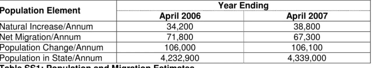
The population of the State was recorded as 4.23 million in 2006 and the population of Connaught was recorded as 504,121, with the population of Galway County standing at 159,256 persons from a recorded figure of 131,613 in 1996 – a 21% increase in a 10 year period compared to the national figure for the same period of 16.7%. In comparison, Galway City grew from 57,241 in 1996 to 72,414 in 2006, an increase of 26.5% in the 10 year period. Estimates of migration since the last Census date in 2006 are as follows:
Year Ending Population Element April 2006 April 2007 Natural Increase/Annum 34,200 38,800 Net Migration/Annum 71,800 67,300 Population Change/Annum 106,000 106,100 Population in State/Annum 4,232,900 4,339,000
Table SS1: Population and Migration Estimates
Source: CSO Population and Migration estimates April 2007, published 18 December 2007.
This shows a marked increase in net migration in the state since the adoption of the current County Development Plan (as revised). The Regional Population growth targets as set out in the Regional Planning Guidelines for the West Region 2010 - 2022 propose a total Western Region population in 2022 of 521,400.
A detailed examination of the dynamics and distribution of population and settlement within the Galway County area for the period 1991 to 2006 indicates the following facts and emerging trends:
1. Galway City has increased its primacy over the County with a strong clustering of jobs and population in and around the City.
2. In addition to a clustering of residential development around Galway City, there is also pressure along the radial road based transport routes to the West and Northwest of the City.
3. A considerable amount of the development pressure has arisen from demand for high numbers of single dwellings, particularly within the commuting zone around the City. This zone extends beyond the County boundary in places, but is most concentrated within 25 kilometres of the City. The towns and villages within this commuter zone have also demonstrated strong growth through the plan period.
4. Continued development of rural housing at current levels, cannot be maintained due to increased service costs, lack of transport provision and negative impacts on the environment especially to water resource quality, habitats and visual amenity.
The key lessons learned from the exercise are that development in County Galway is unevenly distributed and that the trends in rural housing development will inevitably slow or render uneconomic, improvements to infrastructure and services, due to increased unit costs. In order to strengthen the urban fabric of the settlements around the Galway Metropolitan Area , attention should be given to encouraging high quality residential standards within the towns throughout the County. Investment in infrastructure should be focused on the locations that make most planning sense and provide the best economic return. An analysis of the capacity of towns and villages throughout the County to accommodate future growth has been carried out. A total of 103 settlements have been included, ranging from small villages to the large towns of
Ballinasloe and Tuam. They are well distributed throughout the County. Settlements were assessed, not just individually, but as components in a both a Regional and local hierarchy with a view to identifying emerging linkages between settlements as well as clustering of settlements.
The capacity of each settlement was examined on the basis of a range of criteria including the following:
1. The capacity of the settlement to contribute towards achieving the objectives of the Core Spatial Strategy
2. Existing settlement size in terms of population and households.
3. Trends in population and household growth over the last census period.
4. Presence and capacity of water services (i.e. water supply and sewerage), including planned investments in water and waste water infrastructure.
5. Service functions (i.e. number of services, retail units, etc.).
6. Accessibility.
7. Zoned land.
8. Landscape.
9. Heritage (archaeology, architecture, culture).
3.3 Recommended Settlement Strategy
3.3.1
Introduction
Existing local, regional and national policy documents influence the recommended Settlement Strategy for County Galway. The principles of Proper Planning and Sustainable Development, which, along with a top-down, “plan led” approach, are cornerstones of the Planning and Development Act 2000-2006. Proper planning and sustainable development means:
1. Efficient use of energy, transport and natural resources.
2. Effective use of serviced and servicable areas.
3. Best use of existing land and social and utility infrastructure.
4. A good quality of life for all sections of the community.
5. Protection and enhancement of the natural environment.
The Council also recognise that sustainability is an all-embracing concept that must not only have regard to the physical use of resources, but also to the sustainable development and uses of community facilities, resourcesand social outcomes.
The Council recognise that the sustainable development of the County must also have regard to the fact that many rural settlements act as service centres for an established rural areaswith an existing community that must be catered for.
In turn the Council recognise that the sustainable development of rural villages and centres (and the continued maintenance of local social infrastructure such as shops and schools) can be facilitated by development in hinterland areas, which contribute to a critical mass of population, sufficient to maintain local services in declining villages. Development will be permitted which allows for the sustainable continuation of rural communities.
3.3.2
Role of the Galway Gateway and the Galway Metropolitan Area
The envisaged role, in the National Spatial Strategy and Regional Planning Guidelines, of Galway Gateway and the Galway Metropolitan Area is crucial to the future of the County as a whole. The managed growth of the Gateway, designated in the National Plan, benefits the whole of the County and the wider region. The future prosperity of towns and villages near the City and the quality of life of people living in the commuting ring around Galway City depend on the Gateway retaining its dynamic growth character. As an attractor of inward investment and a
provider of regional services and facilities it is essential that the settlement strategy provides for expansion of the Gateway.
3.3.3
Tuam Hub Town
The National Spatial Strategy designated Tuam as a Hub in Ireland’s future spatial structure. Its role as a Hub is to interact with and compliment the Gateway of Galway City, and drive development in rural north east Galway. The Regional Planning Guidelines for the West Region 2010 - 2022 underpin this role and describe the town as “an important industrial and agricultural centre for mid-Connacht”.
The Tuam Local Area Plan 2011-2017 makes provision in its land use objectives for the development needs of Tuam to reach a residential target, as set by the Regional Planning Guidelines 2010, of almost 9,000 people by 2016, and to cater for the commercial, industrial, social and leisure requirements of this growing population.
There is adequate spare capacity in the town’s water supply and effluent treatment systems, and its location on the Western Rail Corridor will, when this facility is restored, provide a sustainable transport link between the western gateways and hubs. There are opportunities to expand and consolidate the town centre and business/enterprise districts of Tuam to capture and encourage sustainable economic growth and accommodate new residents.
It is a key element of the spatial and settlement strategy of the County Development Plan to promote and facilitate the development of Tuam as a town in which people can live and work in a quality and distinctive environment, and which will serve as a dynamic for the social and economic progress of North and East Galway.
3.3.4
Athenry and Settlements along the Rail Corridors
The location of Athenry at the eastern end of the Strategic Corridor and adjacent to the confluence of the new inter-urban routes (M6 and M18) and the junction of the existing easterly rail line with the western rail corridor suggests that it is ideally located to act as a major new growth centre and a Goods Transportation Hub for the county and region. This potential for development is augmented by the convergence of other supporting infrastructure such as the natural gas network and the ease of access to the national power grid. Garraun is a potential site for a new integrated settlement and development node. This would need to be considered in the context of safeguarding the remainder of the county area and settlements and ensuring the funding and provision of infrastructure in these areas are not adversely affected.
3.3.5
Role of Self-Sufficient Towns
Towns, which have a high degree of self-sufficiency, reduce the demand for travel and provide a good quality of life. Outside of the Galway City commuting area there are attractive towns, which either already possess a high degree of self-sufficiency or have the capacity to develop in this manner. Self-sufficient towns are towns where a large proportion of the population living in the towns and the surrounding countryside are able to live, work, shop, go to school and enjoy their recreation, without the need for constant travel. Towns, which fall into this category, are Ballinasloe (not included in this plan), Clifden, Loughrea, Oughterard, Headford and Portumna. There are also towns which function as commuter satellites of Galway City, but which have a strong local service function and have strong or potentially strong local economic bases. .
3.3.6
Dormitory Settlements
There is an attractive and sustainable role for towns and villages close to Galway City as dormitory settlements. There is a sustainable role for towns and villages close to Galway City even though they function partly or wholly as dormitory settlements from which people commute to work and school. A sustainable role requires good transport connections to Galway and good provision of local services and facilities.
Subject to the provision of appropriate services, encouraging the location of residential development unrelated to essential rural needs in the towns and villages in the Galway Transportation and Planning Study area, identified in the strategy, will help to ensure an adequate provision of local services and to create the conditions for better provision of public transport connections in future.
3.3.7
Importance of a Network of Successful Villages and Small Towns
It is the intention of the Council to actively plan and manage the areas that surround many of these towns in association with the Town Councils as they are intrinsically linked to towns which they surround in both their land use and amenity use.
The Council is also committed to working in tandem with Government Departments and State Agencies in identifying suitable locations for new social infrastructure such as schools, recreational facilities, health and care facilities, etc in the towns and villages throughout the county, especially in those rapidly expanding settlements which have struggled to keep pace with population growth.
3.3.8
Planning for Public Transport Provision
Settlements can be planned to encourage public transport provision. Because of its highly dispersed nature the settlement structure of County Galway depends on travel by car. This will continue to be the case even though a high level of dependence is undesirable on social, environmental, and economic grounds. However, significant change, leading to an increase in public transport, can be achieved by adopting a ‘plan-led’ approach. The settlement strategy as a whole proposes the concentration of new residential development in designated settlements instead of a continuation of a general dispersal of growth. The general thrust of the settlement and spatial strategy will improve the conditions for the operation of public transport throughout the county.
3.3.9
Landscape and Environment: Resources to be Protected
The Spatial strategy must preserve the landscape and environmental resources of the County. Beautiful landscapes and clean, fresh water are part of the county’s natural heritage. Where such resources are concerned, the policy imperative must be to avoid damage to the resource.
3.3.10 Houses Constructed
An examination of housing construction in Galway in recent years confirms that housing completions since 2003 are at record levels, the peak being recorded in 2006.
2003 2004 2005 2006 2007
(to Sept.)
2008 Private 3,170 3,199 3,400 (est.) 4,396 2,518 2251
Public 193 190 113 150 81
Table SS2: Housing Constructed
Source: Annual Housing Statistics Bulletins – DoEHLG
3.3.11 Hierarchy of Settlements
The reason for distinguishing settlement hierarchy is that it allows us visualise the relationships between different types of towns within a locality. The hierarchy takes into account more than the size of the town but rather aims to describe the role of the town within its neighbourhood and region. Towns and villages serve a number of roles or functions and a clear-cut, single classification is not always possible. The County Development Planhas adopted a five-tiered system which is broadly in line with the categories as set out in the Guidance Note on Core Strategies issued by the DoEHLG in November 2010
Galway Metropolitan Area
Galway City is a vital economic driver for the entire West region. The types of services provided by the city reach beyond the county boundary. Significant employers include large public service and industrial organisations that draw employees from the network of satellite towns surrounding the city. Within the Galway Metropolitan Area associated with the Gateway are thriving satellite settlements, including Oranmore & Bearna Planned developments in Ardaun and Garraun will also contribute to the strengthening of the Galway Gateway
3.3.12
Hub Town Tuam is the only major hub town identified in the NSS. It is envisaged Tuam will develop as a strong hub town catering for a large catchment within the Region and County.
Other Towns/Key Towns
They provide an extensive range of services including health, community, financial employment and retail. These towns have a strong historical identity as market towns and in most cases have relatively well-developed infrastructure. Sustained growth in these settlements is required to achieve their potential as self-sustaining towns in their own right. These service hubs have, or will have Local Area Plans prepared and implemented to guide development.
Lower Tier Towns
These settlements provide a more limited range of services to smaller hinterlands than service hubs. Service provision often includes a range of retail and educational services but limited financial, health and community services.
Other Settlements and the Countryside
These smaller settlements provide only basic services to their community, such as convenience goods and petrol. Education services normally extend to primary education only. Despite the small number of services, these settlement are distinguished from mere house clusters by the presence of such services which serve an important community purpose and provide the basis for further future development. (Map PD2: Settlement Population shows the distribution of towns and villages within Electoral Areas)
3.4 Settlement Strategy
Using the population projections and targets set out in the Regional Planning Guidelines for the West Region 2010 – 2022, it is estimated that an additional 15,760 persons will be living in the County (not including Galway City) by 2016 .
Based on this new population target,there is a requirement for approximately 6128 units to be distributed based on a sustainable settlement pattern as illustrated in the Core Spatial Strategy. The allocation to the overall tiers shall, in general, be maintained.
3.4.1
GalwayMetropolitan Area
This encompasses settlements in both the Oranmore and Connemara electoral areas but which are outside of the Galway Gateway as defined in the Regional Planning Guidelines for the West 2010 – 2022.. The household growth projection for this area over the period 2009 to 2015, based on the Core Strategy set out in Chapter 2, is for an increase of 635households
Galway Metropolitan Area Additional Population Allocation 2009-2016
Ardaun 100
Oranmore/Garraun 1130
Bearna 420
Small Settlements/Rural Areas
Total (3) 1650
3.4.2
Tuam Hub Town
Tuam Hub Town Additional Population Allocation 2009-2016
Tuam Hub 2080
Total (1) 2080
3.4.2County Town
3.4.3
Other Towns/Key Towns >1500)
Other Towns/Key Towns Additional Population Allocation 2009 – 2016 Loughrea 1133 Athenry 1122 Gort 820 Total (4) 3075
3.4.4
Other Villages(<1500)
Other Villages Additional Population Allocation 2009 – 2016 Moycullen 408 Baile Chlair 245 Headford 251 Kinvara 56 Craughwell 83 Clifden 250 Portumna 230 Oughterard 131 Mountbellew 75 An Cheathrú Rua 105
An Spidéal 25
Clarinbridge 26
Total (10) 1883
3.4.5
Other Settlements and Countryside
Other Settlements/Rural Areas Additional Population Allocation 2009 – 2015
Dunmore, Glenamaddy, Ardrahan, Corofin, Kilcolgan,Moylough, Ballygar, Lackagh, Turloughmore, Abbeyknockmoy Cluain Bu, Cor an Dola, Eanagh Dhuin Ahascragh, Attymon, Monivea, Eyrecourt Banagher, Kilconnell
Aughrim, Caltra, Clonfert Kiltormer, Menlough, Woodlawn Lawrencetown, Fohenagh, Killoran Castleblakeney, Ballinamore Bridge New Inn, Gorteen, Cappataggle
Williamstown, Kilkerrin, Barnaderg, Belcare Kilbennan, Briarfield, Newbridge
Ballymoe, Milltown, Kilconly, Caherlistrane, Brownsgrove, Sylane, Lavally, Foxhall, Newbridge, Cashla
Kiltevna, Glinsk, Ballyglunin, Laragh More Woodford, Killimor, Ballymana, Esker Carrabane, Kiltullagh, Derrydonnell Beg Ballinderreen, Kilchreest, Ballinakill, Moyglass Peterswell, Killeenadeema, Drim, Kilconieran Labane, Tynagh, Kilreekil, Abbey, Bullaun, Castledaly, Coose, Newcastle, Cooloo, Shanaglish
Na Forbacha, An Cnoc, Na Minna An Tulaigh / Baile na hAbhann Ros an Mhíl, Ros Cathail, Tullokyne Leitir Mór, Cill Chiaráin, Cill Rónáin
Roundstone, Carna, Tully / Renvyle, Glinsk Leitir Mealláin, Béal an Daingin
Tullycross, Rosmuc, An Fhairche Leenane, Cleggan, Letterfrack, Casla Corr na Móna, Ballyconneely
Sraith Salach, Claddaghduff
An Mám, Maam Cross, An Aird Mhóir, Maree, Kilbeacanty, Cloghanover,Camus
Total (113) 5533
Over 4000 households can be accommodated in towns and settlements for which Local Area Plans have been, or will be, prepared (including Ballinasloe town which is not included in the County Settlement Strategy). This represents approximately 65% of all the estimated required new households in the County over the plan period.
The remaining households (approximately 2128), including households to be provided in the small settlements as listed above, are considered rural. These households can be accommodated in the rural areas, subject to need arising and in compliance with the policies and objectives set out elsewhere in the Plan and in accordance with the normal principles of
sustainable development and compliance with technical standards. The clustering of new residential development within or close to the named settlements will be encouraged.
3.4.6
Strategic Settlement Policies
Strategic Settlement Policies
Policy SS1: It will be the policy of the Council to recognise the role of Galway city
and the Gateway as key drivers of social and economic growth in the County and in the wider Western Region. The Council will support the growth of the strategic settlements, including Ardaun and Garraun, within the Galway Metropolitan Area.
Policy SS2: It will be a key policy of the Council to secure the development of Tuam
to fulfil its potential as a hub town, catering for the residential, employment, educational, social and retail needs of its target population and for the population of its wider hinterland in north and east Galway.
Policy SS3: It will be the policy of Galway County Council to secure the sustainable
growth of the key service towns of the county to become self –sufficient settlements and act as service centres for the inhabitants of their rural hinterlands
Policy SS4: It will be the policy of Galway County Council to encourage and facilitate
where possible, the sustainable,sequential and balanced development of existing settlements along the strategic emerging road and rail corridors as identified in the Core Spatial Strategy.
Policy SS5: It will be the policy of Galway County Council to support the
development of rural areas in a balanced, sustainable manner, having regard to the social, economic and environmental characteristics of the area and its residents and in accordance with the relevant policies and objectives set out elsewhere in the Plan.
Policy SS6: In the case of smaller settlements for which no specific plans are available, development shall be considered on the basis of its connectivity, capacity (social, cultural and economic) and compliance with the settlement strategy, good design, community gain (this requirement shall not apply to single houses) and proper planning and sustainable development.
Policy SS7: In order to control the scale of development, a deviation in the allocated population of up to 20% will generally be acceptable, between 20% and 30% will be assessed in the context of the group of settlements and the growth experienced by each, over 30% generally will not be accepted. Regard will also be had to the rate of growth in each settlement.
3.4.7
Strategic Settlement Objectives
Strategic Settlement Objectives
Objective SS1: Masterplans and/or Local Area Plans for Briarhill, Ardaun and Garraun will be developed as a priority and brought forward for adoption by the Council at the earliest opportunity within the lifetime of the Plan.
Objective SS2: Local Area Plans or Development Boundaries will be prepared for all Settlements designated as Lower Tier Towns.
Objective SS3: A Local Area Plan for the North Connemara area will be prepared.
Objective SS4: Settlement guidelines or Action Area Plans/Local Area Plans for other key settlements in the Galway Metropolitan Area and along
strategic
public transportation corridors will be prepared as needed during the lifetime of the Plan.
Objective SS5: An Action Area Plan for the off-shore Islands will be prepared.
Objective SS6: A Local Area Plan for Kilcolgan will be prepared based on the Bearna Local Area Plan template.
Objective SS7: To prepare a Local Area Plan as a guidance document for the Carnmore/Galway Airport area to guide future development.