ISSN 2348 – 7968
Geochemistry of Surface Waters, In Ishiagu, Ebonyi State,
Nigeria.
Chinenye F. Edeani
Department of Geology and Mining, Enugu State University of Science & Technology, P.M.B. 01660, Enugu
Abstract
Ishiagu is one of the important lead-zinc mining districts in Nigeria. It is underlain by two sedimentary formations, Abakaliki and Ezeaku Formations. The Abakaliki Formation experienced intense tectonic and intrusive activities during Santonian times that helped establish its geochemical signature. Samples of water were taken from surface waters (comprising rivers, wetlands and pit lakes) in the area and analysed chemically in order to check if the surface mining activities were impacting the water quality in any way. The results showed moderately acidic waters with pH ranging from 4.8 – 6.8, and relatively low solute concentrations. Calcium (CaP
2+
P
) and Sodium (NaP
+
P
) account for more than 80% of the cation chemistry while the dominant anions are bicarbonates (HCOR3RP
-P
) and sulphates (SOR4RP
2-P
). Analysis for heavy metals indicate that all the surface water bodies are polluted with respect to nickel and lead. Only two samples were polluted with respect to manganese. The wetland sample showed promise in the positive modification of polluted water.
Key words
:
Ishiagu; surface waters; nickel; lead; wetlandsINTRODUCTION
Ishiagu is one of the economically important towns in Ebonyi State, southeastern Nigeria. Its economic relevance is basically due to agricultural and mining activities in the area.
Lead/Zinc deposits were discovered in the area in the 1950s according to Bogue (1952) and this has attracted a lot of attention from government establishments and mining companies to the area.
Ishiagu belongs to Ivo local government area of Ebonyi state. It has a population of about 10,000. As a rural community, the primary occupation of the people is farming but a few people work with quarrying companies.
RELIEF AND DRAINAGE
The study area (Ishiagu) has an undulating terrain characteristic of the Cross River Plains geomorphological province. The highest elevation is about 110m above sea level and formed by erosion-resistant igneous intrusives while the lower areas are underlain by soft rocks. Ishiagu is drained by a number of rivers such as Ikwo River, Ivo River, Odu River and Ihetutu streams (Figure 1). The main river Ivo takes its source from the Udi-Okigwe cuesta and then splits into smaller streams such as Ikwo, Ngado, Ihetutu and Eku rivers that create dendritic drainage pattern in the study area.
CLIMATE AND VEGETATION
Ishiagu has two main seasons – a dry season that run from November to March and a rainy season from April to October. According to Ofomata (2002), Ishiagu has annual precipitation of about 1925mm which is relatively high. He also estimates the average temperature to be about 27°C. As part of the sub-savannah, the common vegetation are tall grasses and small trees. Crops commonly cultivated at Ishiagu include rice, cassava, yams and vegetables like pumpkin and spinach.
GEOLOGIC SETTING
The study area is underlain by two rock formations as indicated in the geologic map of the study area (Fig. 2). The oldest is Abakaliki Formation which comprises two
mappable units of shales and sandstones. The shale unit was referred to as Ivo Shale by Ezepue (1984) and consists of clay, siltstones and dark grey calcareous shales while the sandstone unit consists of fine to medium grained calcareous sandstone. The two units dip between 15° to 22° to the northwest, and 20P
0
P
-30P
0
P
to the southeast. The Abakaliki Formation is unconformably overlain by a sandstone member of the Ezeaku Formation. This sandstone member of Ezeaku Formation was dated Turonian by McConnell (1949). It grades from siltstone to fine–medium grained sandstone with dips ranging from 18° to 38° to the southeast direction. Ezepue (1984) described a set of fractures running NW to SW in the area. According to him, these fractures run traversely to the fold axis and may have been due to the tectonic activities that folded the rocks
Figure 3 shows that rocks at Ishiagu are not only mineralized but folded. Infact, there is an anticlinal axis running from Ishiagu towards the north. The mineral deposits at Ishiagu have been studied by Mckay (1946); Reyment (1965); Orajaka (1965) and Olade (1975, 1976). According to Olade and Morton (1980), the lead-zinc deposits were formed as a result
ISSN 2348 – 7968
Figure 3 Geological setting of Ishiagu and Abakaliki pb-zn vein alignment (after Akande and Erdtmann, 1998)
They identified these secondary minerals as anglesite (PbSOR4R), cerussite (PbCOR3R) and smithsonite (ZnCOR3R).
The composition of the igneous rocks at Ishiagu range from intermediate to basic according to Ofoegbu (1985). They occur as dolerite sills and dykes within the Abakiliki Formation. The mineral suite in the sills and dyke include biotite, plagioclase, hornblende, augite, quartz and calcite and has been confirmed by Chukwu (1981) to be of Santonian age. Since the predominant rock formations in Ishiagu are shales, boreholes (i.e. groundwater) are not an important source of water. The people of the area depend primarily on surface water bodies. Surface water bodies include the various streams in the areas, wetlands and pit lakes. The pit lakes were formed by the activities of mining companies. The aim of this paper is to determine geochemical characteristics of surface water bodies in the area. This preliminary assessment will help to indicate whether these surface water bodies are being impacted by the mining activities in the study area or not.
MATERIALS AND METHODS
Water samples were taken from Ikwo river, five pit lakes and one wet land. The sample bottles were flushed with the water to be sampled before collection. Parameters such as EC, TDS, temperature and pH were measured in the field before samples were taken with the aid of a multiparameter water quality meter (Hanna93103). All the temperature measurements were taken at 10am in the morning. In order to stabilize certain chemical species, the samples were acidified to a pH of 2 before samples
were taken to the laboratory. Cations were analysed with the aid of Atomic Absorption Spectrometer (AAS) at FAT LAB, Ibadan, Oyo State Nigeria while the anions were analysed using the methods of American Public Health Association as described by Clesceri et al., (1998).
RESULTS
Results of the chemical analysis of the water samples are given by table 1. This shows the major element chemistry. The pH values of the water ranges from 4.8 at the Obeagu pit lake to 6.8 at the Ihetutu wet lands. Total dissolved solid (TDS) levels indicate waters that range from very dilute to mildly brackish. The range is from 107.2mg/l at Eziato pit lake to 804.0mg/l at the Ihetutu pit lake. This was also confirmed by the values of electrical conductivity which range from 70.9ms/cm to 202.2ms/cm. Cations concentrations in the areas are dominated by calcium and sodium ions. CaP
2+
P
and NaP
+
P
make up over 80% of the major cations. CaP
2+
P
ion rangesfrom 0.40mg/l at Obeagu pit lake to 36.04mg/l at Eziato pit lake while NaP
+
P
goes from 4.21mg/l at Obeagu pit lake to 51.52mg/l at the Ikwo river. MgP
2+
P
varies from 0.20mg/l at Obeagu pit lake to 10.65mg/l at Eziato. Potassium (KP
+
P
) ranges from 0.42mg/l at Obeagu pit lake to 8.31mg/l at the Ikwo river. The dominant anions are bicarbonates and sulphates. Chlorides are somewhat subordinate. Bicabornates (HCOR3R) range from 30.5mg/l
in many of the samples to 61.00mg/l at Eziato pit lake and Ihetutu wetland while sulphates (SOR4RP
2-P
pit lake. Chlorides (ClP
-P
) range from 10.80mg/l at Ihetutu pit lake to 19.80mg/l in Eziato, Ndiuzie and Ikwo river.
Table 1: Chemistry of the major elements of the water samples
Chemical Parameters mg/L
Location
Eziato Pit lake(P1)
Ndiuzie Pit lake(P2)
Ikwo River (P3)
Obeagu Pit lake (P4)
Ihetutu Pit lake(P5)
Ihetutu wetland(P6)
Setraco Lake(P7)
Temp(°C) 30.7 34.0 15.4 18.0 28.8 20.0 15.5
EC µs/cm 160 202.2 80.0 90.4 120.0 100.2 70.9
TDS 107.2 135.3 536.0 630.0 804.0 683.0 529.0
pH 5.1 6.0 5.9 4.8 5.2 6.8 6.2
Calcium (CaP
2+
P
) 36.04 3.11 2.01 0.40 4.16 5.84 18.65
Potassium (KP
+
P
) 0.96 1.94 8.31 0.42 0.61 3.32 4.36
Magnesium (MgP
2+
P
) 10.65 2.08 2.14 0.20 1.72 1.52 4.78
Chloride(ClP
-P
) 19.80 19.80 19.80 14.40 10.80 12.60 14.40
Sulphate(SOR4RP
2-P
) 35.15 22.41 12.46 26.52 19.07 15.40 18.75
Bicarbonate(HCOR3RP
-P
)
61.00 30.50 30.50 30.50 30.50 61.00 30.50
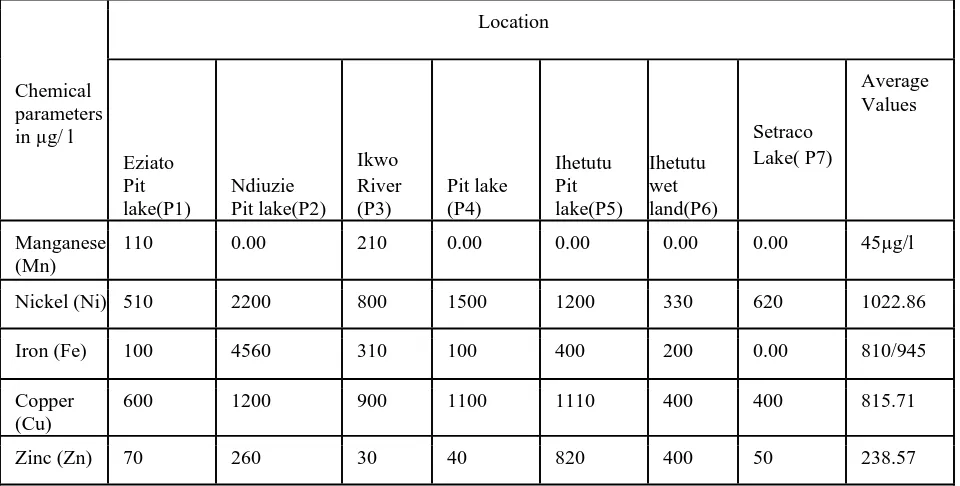
Table 2 shows the heavy metal concentration of the water samples in micrograms per litre. The heavy metals chosen for analysis were manganese (Mn); nickel (Ni); iron (Fe), copper (Cu); Zinc (Zn) and lead (Pb) because of a prior knowledge of the mineral suite at Ishiagu. Manganese (Mn) values range from 0.00µg/l in several samples to 210µg/l at Ikwo River. Nickel (Ni) varies from 330µg/l at Ihetutu wet land to 2200µg/l at Ndiuzie
pit Lake. Total Iron (Fe) goes from zero in the Setraco lake to 4560µg/l at Ndiuzie pit lake. Values of Copper (Cu) varies from 400µg/l at Setraco to 1200µg/l at Ndiuzie pit lake. Zinc (Zn) values go from 30µg/l at Ikwo River to 820µg/l at Ihetutu pit lake. Lead (Pb) varies from 100µg/l at Ihetutu wetland and Setraco lake to 2990µg/l at Ikwo River.
Chemical parameters in µg/ l
Location
Eziato Pit lake(P1)
Ndiuzie Pit lake(P2)
Ikwo River (P3)
Pit lake (P4)
Ihetutu Pit lake(P5)
Ihetutu wet land(P6)
Setraco Lake( P7)
Average Values
Manganese (Mn)
110 0.00 210 0.00 0.00 0.00 0.00 45µg/l
Nickel (Ni) 510 2200 800 1500 1200 330 620 1022.86
Iron (Fe) 100 4560 310 100 400 200 0.00 810/945
Copper (Cu)
600 1200 900 1100 1110 400 400 815.71
ISSN 2348 – 7968
Lead (Pb) 1100 1100 2990 1100 600 100 100 1012.86
DISCUSSION
The pH range of the surface water samples indicate a geochemical environment that range from acidic, mildly acidic to neutral. The low pH of 4.8 maybe an indication of acid mine drainage at the Obeagu pit lake. The almost neutral condition at the Ihetutu wetland (i.e. pH = 6.8) could be a reflection of buffering processes generated by the wet land. It is interesting to note that at the Ihetutu pit lake, the pH is acidic (i.e. 5.2) but changes to neutral in the wet land.
The fact that CaP
2+
P
values are consistently greater than the MgP
2+
P
ions in the waters show that the origin of the waters is primarily meteoric. There is little or no contribution from connate waters that may have contributed magnesium.
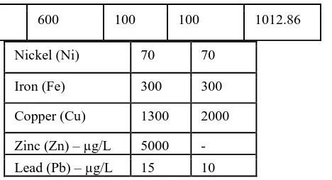
Table 3 shows the maximum contaminant levels (MCL) allowed for manganese, nickel, iron copper, zinc and lead. In some of the parameters, the U.S.E.P.A. guidelines appear to be more stringent. If the guidelines are applied to the heavy metal concentrations in table 2, it will be seen that most of the concentration levels of heavy metals in Ishiagu actually exceed the permitted limits. For manganese, the range in Ishiagu goes from 0.0 µg/l in several samples to 110 µg/l at Eziato pit lake and 210 µg/l at the Ikwo River. The MCL for the WHO/USEPA ranges from 50 – 100 µg/l (table 3). The implication is that Eziato pit lake and Ikwo River waters are polluted with respect to manganese. For nickel, the MCL is 70 µg/l but the range for the study area is 330 – 2200 µg/l with an average value of 1022.86 µg/l which is about 14.6 times greater than the MCL. Iron (Fe) ranges from 0.00 – 4560 µg/l. Its average of 810 µg/l is 2.7 times greater than the MCL permitted by WHO AND U.S.E.P.A. Copper values go from 400 – 1200 µg/l with an average of 815.71 µg/l which is less than the 1300 µg/l MCL prescribed by USEPA. The average value for zinc is 238.57 µg/l which is far less than the 5000 µg/l provided by USEPA. Values for lead range from 100 – 2990 µg/l with an average of 1012.86 µg/l which is 67 times greater than MCL given by USEPA and 101 times greater than that of WHO. The general implication therefore is that many waters in the area are polluted with respect to manganese, nickel and lead. This is certainly connected with anthropogenic activities related to the mining of Lead-Zinc in Ishiagu.
Table 3: MCL (maximum contaminant levels) values for heavy metals according to U.S.E.P.A (2010) and W.H.O. (2006)
Heavy Metals(µg/L)
USEPA WHO
Manganese(Mn) 50 100
Nickel (Ni) 70 70
Iron (Fe) 300 300
Copper (Cu) 1300 2000
Zinc (Zn) – µg/L 5000 - Lead (Pb) – µg/L 15 10
It is interesting to note that the Ihetutu Wetland seems to have low concentration values or most of the heavy metals especially manganese, nickel, iron, copper and lead. It was noted earlier that its pH was a bit higher than other samples. These lower values are due to the geochemical contribution of the wetland processes to the modification of the polluted waters. The studies of Reddy and Delaune (2008) and Kadlec and Wallace (2009) indicate that wetlands can modify the chemistry of polluted waters.
CONCLUSION
This preliminary assessment of the chemical quality status of the surface waters in Ishiagu suggests the surface-mining of lead-zinc in the area is negatively impacting surface water bodies. Further studies will have to be conducted to also assess impacts on groundwater and plants. Eventually it will also be necessary to examine the extent to which the human population has been affected.
Acknowledgement
The effort of Lewis Zigede in digitizing some of the maps is greatly acknowledged. Also FAT laboratory Ibadan which provided the AAS used for the chemical analysis appreciated.
References
1. Akande, S. O. and Erdtmann, B. D., 1998. Burial
metamorphism (thermal maturation) in Cretaceous
Sediments of the southern Benue Trough and Anambra
Basin, Nigeria. AAPG Bull., v.82, p.112-129.
Bogue, R. G., 1952. The lead-zinc deposits at Ishiagu, Ogoja Province, Nigeria: GSN Report No. 1016.
2. Chukwu, D. U., 1981. Distribution of Mineralisation in the Nigerian Basement Complex in relation to Orogenic cycles and structural setting. Proceedings, 1P
st
P
Symposium on the Precambrian Geology of Nigeria.
3. Clesceri, L. S., Greenberg, A. E., Eaton, A. D. (eds). 1998. Standard Methods for the Examination of Water and Waste Water, 20P
th
P
4. Ezepue, M. C., 1984. The geological setting of lead-zinc deposits at Ishiagu, southeastern Nigeria. J. Mining and Geol., v. 2, pp. 97 – 101.
5. Kadlec, R. and Wallace, S. D. 2009. Treatment Wetlands. CRC Press, Taylor and Francis Group LLC, New York, 965pp.
6. Mamah, L. I., Ezepue, M. C. and Ezeigbo, H. I., 2000. Integration of geology and geophysics in mineral exploration in the Benue Trough, Nigeria: the Onuahia lead-zinc deposit – a case study. Global J. Pure and Applied Sci., v. 6, p. 255 – 262.
7. McConnel, R. B., 1949. Notes on lead-zinc deposits of Nigeria and Cretaceous stratigraphy of Benue and Cross River valleys. Geol. Survey of Nigeria. Rept. No. 752. 8. McKay, R. A., 1946. A comparative study of two lead-zinc occurrences in Plateau and Ogoja Provinces. Ann. Rpt. Geol. Survey of Nigeria for 1946.
9. Ofoegbu, C. O., 1985. Interpretation of aeromagnetic profile across the Benue Trough of Nigeria. J. Afr. Earth Sci., v. 3, pp. 293 – 296.
10. Ofomata, G. E. K. 2002. “Relief, Drainage and
Landforms” in “A survey of Igbo Nation” by Africana
Publishers Ltd, Onitsha, pp. 83 – 98.
11. Olade, M. A., 1975. Evolution of Nigeria’s Benue
Trough (Aulacogen): a tectonic model. Geo. Mag., v. 12,
pp. 575 – 583.
12. Olade, M. A., 1976. On the genesis of lead/zinc deposits in Nigeria’s Benue Rift (Aulacogen): a reinterpretation. J Mining and Geol., v. 13, pp. 20 – 27.
13. Olade, M. A. and Morton, R. D. 1980. Temperature of ore formation and origin of the Ishiagu lead-zinc deposit, Southern Benue Trough, Nigeria. J. Mining and Geol., v. 17, pp. 119 – 127.
14. Orajaka, S., 1965. Geology of Enyingba, Ameri and Ameka lead-zinc mines. J. Mining and Geol., v. 3, pp. 49 – 51.
15. Reddy, K. R. and Delaune, R., 2008. Biogeochemistry of Wetlands: Science and Applications. CRC Lewis Publishers; Boca Raton, Florida. 678pp. 16. Reyment, R. A., 1965. Aspects of the Geology of Nigeria: the Stratigraphy of the Cretaceous and Cenozoic Deposits. Ibadan. University Press. 145pp.
17. United States Environment Protection Agency, 2010. Drinking Water Contaminants.