Probable Impacts of Various Range
Improvement Practices on Diffuse Salt
Production
IRADJ K. HESSARY AND GERALD F. GIFFORD
Abstract
During 1976 a study of soil profile salt concentrations and probable salt loading by surface runoff was made on 73 range improvement sites in Utah, Colorado, New Mexico, and Arizona. The range improvement practices studied included gully plugs, contour furrowing, pitting, pinyon-juniper chaining, and various sagebrush-control treatments. Results of these studies indicated that the impact of gully plugs and contour furrows on potential diffuse salt production is somewhat variable and may in fact indicate that these treatments have only a minor potential impact, probably because the overland flow route is not a major source of diffuse salt movement, at least on lands sampled in this study. On pinyon-juniper sites and the various sagebrush treatments, the lack of difference in salt concentrations between treated and untreated sites was the only consistent trend. In general the measured salt concentrations in surface soils of either pinyon- juniper or sagebrush sites present a problem of little concern as
related to salt production within the major river basins.
Salinity in the Colorado River is of major national concern, for not only has it resulted in losses to the regional economy, but also high salinity levels have aggravated relations with the Republic of Mexico. Even in its virgin state, the salt load of the Colorado River in its lower reaches was about 600-700 ppm. However, man’s development of water resources has affected both the quantity and quality of water supplies. Salinity levels in the lower reaches of the river now average 850 ppm with a predicted concentration of 1,300 ppm by the year 2000.
The sources and causes of dissolved solids within the Colorado River are of importance; for if they can be identified, strategies may be developed for effective management and control. In addition, this information would allow estimates to be made of downstream costs associated with upstream salt production, thus facilitating the development of economic trade-offs on a basin-wide level.
Recent estimates suggest that the largest single man-caused source of salinity is irrigation return flow, amounting to about a third of the total salt load. Natural sources such as salt wells and springs, plus concentration by evaporation, account for another third. The remaining salt load is attributed to diffuse sources
Authors are graduate research assistant and associate professor, rangeland hydrology, Watershed Science Unit, College of Natural Resources, Utah State University, Logan, 8-1311.
This research was supported jointly by the Bureau of Land Management (Contract 51X)0-CTS- 16) and the Utah Agricultural Experiment Station, Project 4 I?. The authors are grateful to Dr. Al Southard, Department of Soils and Biometeorology, forassistance in classification of soils. Journal paper 129 I, Utah Agricultural Experiment Station.
Manuscript received April 14, 1978.
originating on immense areas of wildland watersheds, and particularly rangeland watersheds.
This study deals with the application of various range improvement practices for eventual formulation of land management programs that may influence diffuse salt produc- tion from rangelands. Data on these aspects are sparse. For example, Soiseth et al. (1974), in southeastern Montana, found that soil salinity in upper soil depths was not reduced in comparison to the check on any of several panspot range sites that had been contour furrowed. Contour furrowing did, how- ever, affect movement of salts (through increased infiltration) in the O- to IO-cm depth in the furrows. Branson et al. (1966) near Fort Peck, Montana, found that 10 years after furrowing and seeding there was a decrease in salts (Ca, Mg, Na) in the upper 60 cm of the treated soils and an increase in salts below 60 cm. This leaching was assumed to have taken place during the years immediately after treatment because above-ground water storage in furrows decreases with time. Wein and West (1973), near Cisco, Utah, on Chipeta series, a member of the clayey mixed calcareous mesic typic torriorthents soil family, found no accumulation of salt in contour furrows or gully plugs 5 to 6 years following construction. Their data suggested some initial early leaching of salts due to treatments, while the present trend, as evidenced by infiltration measures, suggested a possible accumulation of salts.
The specific objective of this study was to determine the effects of existing land treatments on soil profile salt concen- trations and probable salt loading by surface runoff.
General Description of Study Area
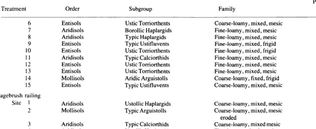
Seventy-three study sites located primarily in Utah, Colorado, New Mexico, and Arizona (one site) were included in this study. The range improvement practices studied include contour furrowing (11) sites, pitting (2 sites), pinyon-juniper chaining (14 sites), gully plugs (6 sites), and various sagebrush control treatments (40 sites). The sites in Utah (32 sites) lie primarily in Grand, Emergy, Carbon, and San Juan CoBBtieS; in Colorado (12 sites), Montrose, Gunnison, Dolores, and San Miguel counties; in New Mexico (28 sites), Valencia, Sandoval, Rio Arriba, and San Juan counties; and Maricopa county in Arizona ( 1 site). General topographical, soils, and vegetation descriptions of the sites have been given previously by Hessary and Gifford (1979). More specific information is given in Table 1.
increasing soil moisture, grazing capacity, and nutritional value of forage. Crested wheatgrass (Agropyron cristatum), tall wheatgrass (Agropyron elongutum), western wheatgrass (Agrupyron smithii), Russian wildrye (Elymus juncus), side-oats grama (Bouteloua curtipertdula), alkali sacaton (Sporobolus uiroides), sand dropseed (Sporobolus cryptundrus), sweet clover (Mellilotous ofiicinulis), and four-wing saltbush (Atriplex cunescens) are the main species which were seeded on the various sites.
Methods and Procedure
This study was carried out during 1976 in cooperation with various Bureau of Land Management districts. Age of treatment, acreage involved, geographic location, and methods of applying treatments were used for determining the approximate number of sites to be sampled. Topographical maps were used to determine the general location of various sites, while field studies established the exact location of sampling sites. Specific criteria such as how typical the site was of the general area and its predominant geologic type were considered in final site selections.
Field Methods
A “treated” and nearby similar “untreated” sampling site, each with an area of approximately 23,409 m’ (2.3 ha), were selected for each treatment location. All on-site measures, including collection of soil samples (see below), were taken only once at each site. Statistical evaluations are therefore limited to treated vs. untreated comparisons within a given location rather than among all locations.
Soil Surnpling
For the pitting treatments, pinyon-juniper chainings, and all sage- brush treatments, there were five replications (or sampling locations) for each treated and adjacent untreated site; one at each corner of the 2.3.ha sampling site and another in the middle. At each of the five sampling locations within a treatment, soil samples were collected at the O-0.5, 0.5- 1, l-7.5, and 7.5-17.5 cm soil depths. When possible, at the middle location, soil samples were taken at depths beyond 17.5 cm (usually at 7.5-cm increments) to allow for a more complete characterization of soil particle size with depth.
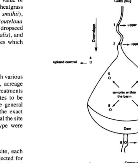
On gully plug treatrnents there were three replicattons foreach gully plug treatment site, and in each replication soils from nine positions were sampled at incremental depths indicated above. Within each gully plug replication there were two sampling positions termed “upper channel control,” one position termed “lower channel con- trol,” two positions termed “upland control,” and four positions inside the gully plug basin (Fig. 1).
On the contour furrowing treatments, four line transects were established on a representative sampling site across each contour furrow treatment. Four positions were selected on each line: the first was on the upland area between the furrows, the second at the bottom of the furrow, the third on the spoil (ridge), and the fourth on the lowland area between the furrows (Fig. 1). Soil samples were taken at depths indicated above.
Laboratory Methods Soil Analysis
Electrical conductivity (EC) measurements and particle-size analyses were made in the laboratory. For the EC measures, extracts from a saturated soil paste (1: 1 ratio; 100 g of soil and 100 cc water) were read using a Beckman Conductivity Bridge (Model RC- 19). All conductivity data (in micromhos per centimeter) were converted to a standard reference temperature of 25°C (U.S.D.A., Handbook 60,
1954).
Particle-size distribution was determined from soil samples taken from a single representative position on each treated and untreated site using the hydrometer method (Bouyoucos 1962).
Stutistical Analysis
All results from the field and laboratory analyses were analyzed using standard analysis of variance techniques on a per site basis.
Gully plug
8
1 - upper dwnnel control
I i
H
2 - upper chanml control 4
uphdamtrol - 0 / \ i _ upland control
9 0 - lomr channel control
II
oowndop Contour Furrow furrow
ori@nd wnd w h
t
spoil bmnk 0
1 0
0 4 Control position 2 UXltrOl poritiw
Fig. 1. Plan view oj gully the sampling positions.
plug and cross-section contour furrow showing
When analyzing EC data from the contour furrow treatments, values for control-positions No. 1 and 4 (Fig. 1) were combined at similar depths on each transect line. There were therefore three positions, each with four depth increments.
For the gully plug treatment (Fig. 1) EC values at similar depths at points 3 and 4 were pooled and EC measures inside the gully basin at sampling points No. 5,6, 7, and 8 were also pooled for analysis. Data from the resulting five points were used in the statistical analysis. Significant differences among means for all analyses were determined using standard LSD procedures.
Results and Discussion
Gully Plugs
Salt accumulations in the soil profile were significantly different among sampling positions on three out of six gully plug treatments. However,-the significant differences showed no consistent trend. For instance, one site indicated higher salt concentration in the upland control (position 3, Fig. 1) than in the other positions. In another case, higher salt concentrations were indicated inside the gully basins (position 5) than in positions, 1, 2, 3, and 9 (no significant-differences existed among these latter positions). On a third gully plug treatment, lower salt concentrations were found inside the gully basin (position 5) than at positions 1, 2, 3, and 9 with no significant differences among the latter positions.
In four cases out of six, salt distribution within the soil profile was significantly different among the depth increments. In two cases the two surface soil increments (depth 1 and 2) showed higher salt concentrations than the lower depths. The other two gully plug treatments had higher salt concentrations in the lower depths. In only one case was there a significant depth x position interaction.
Table 1. Soil classification, approximate annual precipitation, and date of treatment for various range improvement practices sampled in this study.
Treatment Order Subgroup Family
Precipitation Treatment
(mm) year
Contour furrowing Site 1
2 3 4 5 6 7 8 9 10 11
Alfisols Typic Cryoboralfs Coarse-loamy, skeletal, mixed 305 1962
Entisols Ustic Torriorthents Fine, mixed, mesic 356 I963
Mollisols Typic Argiborolls Fine, mixed, frigid 762 I963
Entisols Typic Ustifluvents Fine, mixed, frigid 762 1948
Entisols Ustic Torrifluvents Fine-loamy, mixed, mesic 356 1965 Entisols Ustic Torriorthents Fine-loamy, mixed, mesic 356 I966 Aridisols Typic Calciorthids Coarse-loamy, mixed, thermic 178 1969 Aridisols Ustollic Haplargids Fine-loamy, mixed, mesic 229 1964 Entisols Typic Torriorthents Fine, mixed, mesic, shallow 203 1968 Entisols Typic Torriorthents Fine, mixed, mesic, shallow 203 1969 Entisols Typic Torriorthents Fine, mixed, mesic, shallow 229 1967
Pitting Site 1
2
Entisols Typic Torriorthents Fine, mixed, mesic 254 1958
Entisols Typic Torrifluvents Sandy, mixed, mesic 254 1975
Pinyon-juniper chaining
Site I 2
3 4 5 6 7 8 9 10 11 12 13 14
Mollisols Typic Argiustolls Fine-loamy, mixed, mesic 508 1961 Aridisols Ustollic Haplargids Fine-loamy, mixed, mesic 356 1960 Mollisols Aridic Haplustolls Fine-loamy, mixed, mesic 356 1960 Aridisols Ustollic Haplargids Fine-loamy, mixed, mesic 356 1961 Aridisols Ustollic Haplargids Fine-loamy, mixed, mesic 406 1962 Aridisols Ustollic Haplargids Fine-loamy, mixed, mesic 356 1962 Aridisols Typic Calciorthids Fine-loamy, mixed, mesic 330 1964 Aridisols Ustollic Calciorthids Loamy-skeletal, mixed, mesic 406 1964 Mollisols Aridic Argiborolls Fine-loamy, mixed, mesic 356 1965 Aridisols Typic Calciorthids Coarse-loamy, mixed, mesic 305 I968
Mollisols Typic Fine-loamy, mixed, mesic 356 1968
Mollisols Typic Haplustolls Fine-loamy, mixed, mesic 356 I969 Mollisols Typic Argiustolls Fine, mixed, mesic, shallow 203 1970 Aridisols Ustollic Haplargids Fine-loamy, mixed, mesic, shallow 279 1971
Gully plugs
Site 1 2 3 4 5 6
Entisols Typic Torriorthents Fine, mixed, mesic, shallow 203 1960 Entisols Typic Torriorthents Fine-loamy, mixed, mesic, shallow 203 1963 Entisols Ustic Torriorthents Fine-loamy, mixed, mesic 356 1966 Entisols Typic Torriorthents Fine-loamy, mixed, mesic, shallow 203 1964 Entisols Typic Torriorthents Fine-loamy, mixed, mesic, shallow 203 I962 Entisols Ustic Torrifluvents Fine-loamy, mixed, mesic 254 1963
Sagebrush ripping
Site 1
2 3 4
Entisols Ustic Torriorthents Aridisols Typic Camborthids Entisols Ustic Torriorthents Entisols Typic Torrifluvents
5 Aridisols 6
;
Entisols Aridisols 8 Entisols 9 Aridisols 10 Entisols 11 Entisols 12 Entisols 13 Entisols
Sagebrush plowing
Site 1
L
3 4 5
Mollisols Calcic Argiustolls Fine-loamy, mixed, mesic 305 1945 Aridisols Ustollic Haplargids Fine-loamy, mixed, mesic 279 1954 Aridisols Ustollic Haplargids Coarse-loamy, mixed, mesic 279 1960 Mollisols Typic Arguistolls Fine-loamy, mixed, mesic 356 1961 Mollisols Typic Haploborolls Fine-loamy, mixed, mesic 305 1962
Sagebrush chaining Site 1
2 3 4 5
Aridisols Entisols Mollisols Aridisols Aridisols
Typic Camborthids Typic Torriorthents Ustic Haplargids Ustic Torrifluvents Ustollic Haplargids Ustic Torriorthents Typic Torrifluvents Ustic Toniorthents Ustic Torriorthents
Fine, mixed, mesic Fine-loamy, mixed, mesic Fine-loamy, mixed, mesic Coarse-loamy, montmorillonitic,
mesic
Fine-loamy, mixed, mesic
Fine-loamy, mixed, mesic, shallow Fine-loamy, mixed, mesic
Fine-silty, mixed, mesic Fine-loamy, mixed, mesic Fine, montmorillonitic, mesic Fine-loamy, mixed, mesic Fine, mixed, mesic
Fine-loamy, mixed (calcareous), mesic, shallow
Ustollic Haplargids Fine-loamy-skeletal, mixed, mesic Ustic Torrifluvents Sandy, mixed, mesic
Lethic Arguistolls Fine-loamy, mixed, mesic Typic Calciorthids Fine-loamy, mixed, mesic Lithic Ustollic Fine-loamy-skeletal, mixed,
Haplargids mesic
254 1957
254 1958
406 1958
254 1959
254 1960
279 1961
305 1963
406 1963
254 1965
305 1965
203 1965
406 1967
305 1969
305 1948
356 1949
330 1951
279 1956
Table 1. Continued
Treatment Order Subgroup Family
Precipitation Treatment
(mm) year
6 7 8 9 10 11 12 13 14 15
Sagebrush railing
Site 1
2
3 4 5 6 7
Entisols Ustic Torriorthents Aridisols Borollic Haplargids Aridisols Typic Haplargids Entisols Typic Ustifluvents Entisols Ustic Torriorthents Aridisols Typic Calciorthids Entisols Ustic Torriorthents Entisols Ustic Torriorthents Mollisols Aridic Arguistolls Entisols Typic Ustifluvents
Aridisols Ustollic Haplargids Mollisols Typic Arguistolls
Aridisols Typic Calciorthids Aridisols Ustollic Haplargids Aridisols Ustollic Haplargids Aridisols Ustollic Haplargids Aridisols Ustollic Haplargids
Coarse-loamy, mixed, mesic Fine-loamy, mixed, mesic Fine-loamy, mixed, mesic Fine-loamy, mixed, frigid Fine-loamy, mixed, frigid Fine-loamy, mixed, mesic Fine-loamy, mixed, mesic Fine-loamy, mixed, mesic Coarse-loamy, fixed, frigid Coarse-loamy, mixed, mesic
Coarse-loamy, mixed, mesic Coarse-loamy, mixed, mesic
eroded
Coarse-loamy, mixed mesic Fine-loamy, mixed, mesic Fine-loamy, mixed, mesic Fine-loamy, mixed. mesic Coarse-loamy, mixed, mesic
279 1961
406 1962
279 1962
406 1964
305 1965
305 1966
35 1966
356 1966
305 1970
356 1951
305 1950
508 1952
305 1955
305 1956
330 1958
356 1961
279 1962
Contour Furrows Conclusions
In three out of 11 contour furrow treatments, salt concen- trations were significantly different among the three sampling positions (Fig. 1). Two treatments had significantly higher salt concentrations inside the furrow (at position 2), while one treatment had significantly higher salt concentrations outside the furrow (at position 1). For the three treatments there were few significant differences between ridge (spoil) and control (position I), or spoil and furrow.
During 1976 various range improvement practices, including gully plugs, contour furrowing, pitting, pinyon-juniper chain- ing, and various sagebrush control treatments, were studied in Utah, Colorado, New Mexico, and Arizona. Emphasis was placed on probable salt loading as a function of the above treatments. The following represents the major findings. :
There were significant differences in salt concentrations as a function of soil depth on eight of the eleven contour furrow treatments. The general trend indicated higher salt concentra- tions in the two surface layers in nonsaline soils, with almost equal quantities of salt at the third and fourth depth increments. On saline soils the lower depths had higher salt concentrations than the two surface layers. There were few significant dif- ferences between the third and fourth depths.
Pittings
Analysis of variance for the two pitting treatments showed no consistent trend in salt concentrations as a function of different soil depth increments.
1. Salt accumulations in the soil profile were significantly different among sampling positions on three of six gully plug treatments. However, the significant differences showed no consistent trend. Likewise, significant differences in salt con- centrations as a function of soil depth were never consistent among the gully plug treatments. The impacts of gully plugs on diffuse salt production therefore appears mixed, perhaps some- what site specific, and perhaps a function of age and exposure to runoff producing storms. Lack of consistent results can also be interpreted as gully plugs having only minor potential impacts on diffuse salt production, probably because the overland flow route is not a major source of diffuse salt movement, at least on the lands sampled in this study. Studies by Ponce and Hawkins ( 1978) and White (1977) would seem to indicate this.
Pinyon-Juniper Chainings
On three of 14 pinyon-juniper sites, salt accumulations were significantly lower in the surface 0.5 cm soil layer of treated sites. However, the only really consistent pattern at any soil depth was the lack of difference in salt concentrations between treated and untreated sites. Based on EC measures in surface soils (maximum EC values 675 mmhos/cm) and at greater depths (maximum EC value 445 mmhos/cm), salt concentra- tions should not be a major concern on pinyon-juniper sites similar to those sampled in this study.
2. On contour furrowing treatments, salt concentrations on three of 1 1 sites were significantly different among sampling locations. Two treatments had significantly higher salt con- centrations inside the furrow while one treatment had signifi- cantly higher salt concentrations outside the furrow. Based on this study it would appear that impacts of contour furrowing treatments on salt loading can be interpreted as similar to those for gully plugs. Evidence of salt accumulations within the furrows were absent on 73% of the sites sampled.
Sagebrush Treatments
For the most part there were few differences between treated (chained, ripped, plowed, and railed) and untreated sites, regardless of soil texture. As with indicated salt concentrations on pinyon-juniper sites, EC values as measured on sagebrush
sites in this study do not indicate a need for major concern as related to salt production within major river basins.
Literature Cited
Bouyoucos, G.J. 1962. Hydrometer method for making particle size analysis of soils. Agron. J. 54:4640465.
Branson, F.A., R.F. Miller, and IS. McQueen. 1966. Contour furrowing, pitting and ripping on rangelands of the western United States. J. Range Manage. 19:182-190.
Gifford, G.F. 1975. Beneficial and detrimental effects on range improvement practices on runoff and erosion. In: Proc. A.S.C.E. Symp., Watershed Management, Utah State University, Aug. 1 l- 13, Logan: 2 16-248.
Hessary, I., and G.F. Gifford. 1979. Impact of various range improvement practices on watershed protective cover and annual production within the Colorado River Basin. J. Range Manage. 32: 134-140.
Ponce, S.L., and R.H. Hawkins 1978. Salt pickup by overland flow in the
Price River Basin, Utah. Water Resour. Bull. 14: I 187-1200.
Soiseth, R.J., J.R. Wright, and J.K. Aase. 1974. Improvement of panspot (Solonetzic) range sites by countour furrowing. J. Range Manage. 27:107-l 10.
U.S. Salinity Laboratory Staff. 1954. Diagnosis and improvement of saline and alkali soils. U.S.D.A. Handbook No. 60.
Wein, R.W., and N.E. West. 1973. Soil changes caused by erosion control treatments on a salt desert area. Soil Sci. Sot. Amer. Proc. 37:98-103.
White, R.B. 1977. Salt production from micro-channels in the Price River Basin, Utah. MS Thesis, Utah State Univ., Logan: 121 p.
Wight, J.R. 1975. Land surface modifications and their effects on range and forest watersheds. In Proc. 5th Workshop, U.S. Australian Rangelands Panel, Boise, Idaho, June 1522:165-174.
CALL FOR PAPERS
33rd Annual Meeting, February 11-14, 1980 San Diego, California
“People Impacts on Rangelands” will be the theme. Come to San Diego and join in the program-as a speaker, as a Town Hall panel member, or as part of an actively participating audience. The committee for the 1980 Annual Meeting has introduced two innovations aimed at stimulating interactions among all attendees at the meeting.
Town Hall Sessions will involve 4-way interaction among: (1) the Chairman, (2) two Invited Speakers who will present short papers, (3) a panel of at least six “Resource People” who will not present papers, and (4) the entire audience. For each session the Chairman will develop the approach to be followed, will invite the two speakers, and will select the persons to serve as resource people- volunteers’ for resource people are needed from those SRM members particularly interested in the Town Hall subjects. The Chairman, speakers, and resource people will prepare short summaries (less than two double-space pages) of their ideas and main points to be discussed. The printed summaries, along with abstracts of technical papers, will be available to the audience at the time of registration. We hope this kind of session will stimulate maximum SRM membership interest with minimum time devoted to formal presentations.
Subjects for the Town Hall Sessions will be: (1) Role ojpeople in rungeland ecosystems; (2) Use ojjire on rangelands; (3) Animal relationships (Livestock/Wildlife/Fisheries) on rangelands; and (4) Communications within SRM.
Technical Sessions will allot 20 minutes, instead of the usual 15, to each speaker’s subject. The Chairman for each session will make sure that at least 5 minutes will be used for discussion. Otherwise, the technical sessions will fit the pattern of previous meetings.
Deadlines and Procedures for Submitting Papers
1. By June 15, 1979, submit title of proposed paper(s). On a separate sheet for each paper include the title, intended subject matter area, name of the author(s), address of the one person to whom correspondence is to be sent, and a brief supporting statement on main points to be covered and their significance to the 1980 meeting.
Individuals volunteering to serve as resource people in Town Hall sessions must submit well-prepared statements.
Authors of volunteer technical papers will be sent instructions for preparing abstracts in a standard format. Similar instructions for preparing standardized summaries will be sent to persons selected as speakers or resource people in Town Hall sessions.
2. By September 1.5, 1979, submit abstracts, or summaries, complete with the title, names of author(s), and author affiliations. Authors of volunteer technical papers and persons selected as resource people in each Town Hall session will be notified by October 15, 1979, of their acceptance and assignment to specific sessions.