SUSTAINABLE MANAGEMENT OF RAIL LAND: A CASE STUDY OF NAIROBI COMMUTER RAIL NETWORK.
KIARIE PAULINE WAMBUI B.A LAND ECON (HONS)
N50/CTY/PT/23349/2012
A RESEARCH PROJECT SUBMITTED IN PARTIAL FULFILMENT OF THE REQUIREMENTS FOR THE AWARD OF MASTERS DEGREE IN ENVIRONMENTAL PLANNING AND MANAGEMENT OF KENYATTA
UNIVERSITY
ii
DECLARATION Student
This proposal is my original work and has not been presented for a degree in any other university.
Name : Kiarie Pauline Wambui
Signature : Date
Admission No: N50/CTY/PT/23349/2012
Supervisors
This proposal has been submitted with our approval as University Supervisors.
Name : Dr. Peter K. Kamau
Signature : Date
School of Environmental Studies: Department of Environmental Planning and Management
Name : Dr. Sammy Letema
Signature Date
iii
DEDICATION
iv ABSTRACT
v
ACKNOWLEDGEMENT
In the current world, great achievements result from the culmination of small discoveries or ideas of many actors. The culmination of this report is such an experience; many have been the actors of whom without their support the report would not have been a success.
The researcher appreciates the training, instruction, information, comments and suggestions contributed by the supervisory team led by Dr. Peter K. Kamau and Dr. Smmy Letema, the management of Kenya Railways Corporation and Rift Valley Railways for not only providing information and data but also facilitating field data collection along the rail network through their respective concession departments represented by Engineer Benedict Kimau and Mr. Sammy Gachuhi respectively.
I also wish to convey my heartfelt gratitude to all who contributed to this exercise, but whose names and designation may not have been stated in the project.
vi TABLE OF CONTENTS
DECLARATION………...ii
DEDICATION…………..iii
ABSTRACT……… ……..iv
ACKNOWLEDGEMENT……………….v
TABLE OF CONTENTS……….vi
LIST OF TABLES………ix
LIST OF FIGURES………...x
LIST OF PLATES………....xi
CHAPTER ONE: INRODUCTION………....1
1.1 Background to the Problem ... 1
1.2 Problem statement ... 2
1.3. Research Questions ... 4
1.4. Objectives of the study... 4
1.4.1 General Objective of the Study ...4
1.4.2 specific objectives ...4
1.5 Significance of the Study ... 5
1.5.1 The Government ...5
1.5.2 Investors/ managers ...5
1.5.3 Academicians/ researchers ...5
1.6 Assumptions of the study ...5
1.7 Scope of the Study ... 6
1.8 Limitations to the study ... 6
CHAPTER TWO: LITERATURE REVIEW………..8
2.1 Sustainable land management ... 8
2.2 Concepts and Frameworks ... 9
2.2.1SLM and Rational Use of Land Resources (RULR) ...9
2.3 Theoretical Framework ... 10
2.3.1Global context of change ...11
2.4 Concepts in Sustainable Development ... 11
vii
2.4.2 Multi-level stakeholder approach ..……….. ………12
2.4.3 Disciplinary, multi-disciplinary, interdisciplinary and transdisciplinary research ...12
2.5 Research gap ... 13
2.6 Conceptual Framework ... 14
CHAPTER THREE: AREA OF STUDY…..………15
3.1 Physical set up ... 15
3.2.1 Location and extent ...15
3.2.2 Topography and drainage ...16
3.2.3 Climate ...17
3.3.1 Agro ecological zones ...18
3.3.2 Vegetation ...18
3.3.3 Wildlife ...18
3.4 Economicalset up………...18
3.4.1 Agriculture ...18
3.4.2 Trade, commerce and industries ...18
3.5 Social set up ... 19
CHAPTER FOUR: RESEARCH METHODOLOGY………...20
4.1 Introduction ... 20
4.2 Research Design and location of the study ... 20
4.2.1 Research Design ...20
4.2.1 Qualitative and Quantitative Research ...21
4.2.2 Mixed Methods ...22
4.3 Target population and Sample Selection ... 22
4.4 Research Instruments ... 23
4.5 Pilot Test ... 23
4.5.1 Validity ...24
4.5.2 Reliability ...24
4.6 Data Collection methods ... 25
4.6.1 Interviews with Policy Makers ...25
4.6.3 Data Analysis……… ... .25
4.6.3.1Qualitative data ...25
viii
CHAPTER FIVE: DATA PRESENTATION AND DISCUSSION ……… ………..26
5.1 Existing legal, statutory, regulatory and institutional framework affect the Nairobi Commuter Rail Land use ... 27
5.2 Challenges hindering sustainable management of Rail Land ... 29
5.3 Relationship between Nairobi commuter Rail Land use and Nairobi Urban Land use structure ... 33
4.4 Impact of encroachments and informal settlements on the Nairobi commuter Rail Land use ... 36
CHAPTER SIX: SUMMARY OF THE FINDINGS, CONCLUSION AND RECOMMENDATIONS……….41
6.1 Summary ... 42
6.2 Conclusion ... 43
6.3 Recommendations ... 43
6.4 Areas for Further Studies ... 44
REFERENCES ... 48
ix LIST OF TABLES
x
LIST OF FIGURES
Figure 1: Satisfaction with current services ...29
Figure 2: Preference for train services ...30
Figure 3: Commuters’ opinions of the problems of Commuter train services in Nairobi ...30
xi
LIST OF PLATES
Plate 1: Location of Nairobi County ... 15
Plate 2: Master Plan for Nairobi Commuter Rail Development ... 16
Plate 3: Road and rail drainage during rainy seasons ... 17
Plate 4: New Syokimau Station ... 35
Plate 5: Construction on Imara Daima and Makadara Railway Stations ... 36
Plate 6: Encroachment of rail reserve in Kibera and Mukuru Slums in Nairobi ... 37
Plate 7: Tracks in Nairobi old Makandara Station exposed to surfdace runoff...38
Plate 8: Rail under bridge crossing with encroachments and garbage endangering both the rail and road transport...38
1
CHAPTER ONE: INRODUCTION 1.1 Background to the Problem
Rail transport is a vital component for the entire transport system in a country. It facilitates the movement of goods along a supply chain and therefore it is indispensable for the supply of goods and directly influences the efficiency of the economy (Lai et al., 2003). As a result, transport demand is closely linked to economic development. The amount and character of rail transport demand is determined by logistics decisions, which aim to move product efficiently along a supply chain. Changing logistics structures, e.g. decisions to centralize warehousing, and more just-in-time replenishment have led to an increasing demand for the delivery of smaller units in higher frequency and an increasing importance of time, reliability and speed (Liao, 2005).
Ball, Lizieri, & MacGregor (2008) findings indicate that between 1995 and 2008 the average annual growth of intra European Union (EU-27) freight transport was 2% and hence rail transport grew as fast as the economy, and during the economic downturn (2008-2009) when the GDP in EU-27 decreased by 4.2% rail transport dropped by 11.2% (Ball et al., 2008). The increasing demand for small volume goods flows of at more frequent intervals has limited the scope of rail to maintain market shares and many industries have increased their reliance on road transport. As a consequence, the growing demand for freight is mainly met by road while the market share of rail fell from 21% of total EU-27 inland freight transport in 1995 to 17% in 2008 (Alexander, 2011)
2
economic and technological trends including higher energy prices, speeds containerization and new increases in flows of bulk trade and traffic (Dixit, 2006). Most of the railway network in the sub-Saharan Africa was inherited from the colonial regimes and not much has been developed from then on.
According to Coase (2007), rail transport is the second most important mode of transport in Kenya, after road transport, for both freight and passenger services (ERSWEC 2003-2007). The railroad system in Kenya consists of the national railway network transport and the metropolitan network. The Economic recovery strategy for wealth and employment creation identified the transport sector as the third pillar of Kenya’s economic recovery. Klein, Moore, & Reja (2009) acknowledge that the metropolitan rail transit commuter trains were introduced by the Kenya Railway in1992, to help ease transportation to the suburbs and this service was well received despite the high fares. It is important to note at the beginning that there is no exclusive network which has been developed for mass rail transit within Nairobi city and its environs (Klein et al., 2009). Rather, the rail transit network was, and has been run on the sections of the main lines and branch lines radiating from the city to the hinterland. The existing network has neither been changed nor improved from colonial times despite the overwhelming need for mass transit services and the changing technology (Lai et al., 2006).
It is in line with this background that this study proposes to study sustainable management of Rail Land within commuter rail networks in Nairobi with an aim to address and avert negative issues that arise due to improper management of Rail Land. Establishment of the aforementioned issues is crucial to identifying key priority areas for policy and practice to increase sustainable management of the entire railway transport.
1.2 Problem statement
3
within the CBD (Dixit, 2006). The CBD has for a long time been subjected to numerous traffic problems, which have been exacerbated by lack of space in its vicinity.
Past studies have chiefly focused on the general expansion of transport industries in order to accommodate the ever increasing population in Kenya. For instance, Lewis (2010) assessed the increasing demand of rail services in Nairobi noting that a large percentage of low-income users of public transport now live further away from the CBD. Klein et al. (2009) looked at the impact of the increasing population on the transport sector noting that expansion of the city to the east, south, and north has not been matched by an expansion in transport facilities and services. The annual rate of growth of daily passenger journeys is currently estimated to be almost 6 per cent (Klein et al., 2009).
It is important that new developments made to the transport system must be carefully planned so as not to unduly expose residents to railway activities as well as not to interfere with the land reserve areas, or the potential for future expansion, as railways play an important economic role in society that must be safeguarded.
Liao (2005) in a study on use of railway land argues that there is an overwhelming demand for a convenient, efficient and descent commuter rail service and network within and around Nairobi. Lai et al., (2003) highlights the fact that there exists an underutilized railway network that can be modernized and expanded to increase rail commuter numbers. However, the Kenya Government has over time experienced financial, technical and operational problems as a result of prevailing political, institutional, economic, environmental, socio-cultural factors thus inadequate investment (Coase, 2007). Thus the development of metropolitan rail system has not been spared.
4 1.3. Research Questions
The research will concern itself in answering the following questions:
i. How does the existing legal, statutory, regulatory and institutional framework affect the Nairobi Commuter Rail land use?
ii. How does the current land use of the rail corridor affect the Nairobi Commuter network? iii. How does the Nairobi commuter Rail land use relate with the Nairobi Urban Land use
structure?
iv. What is the impact of encroachments and informal settlements on the Nairobi commuter rail land use?
1.4. Objectives of the study
1.4.1 General Objective of the Study
The objective of this study is to empirically investigate ways through which sustainable management of Rail Land can be met within Nairobi commuter rail network.
1.4.2 specific objectives
i. To analyse the existing legal, statutory, regulatory and institutional framework affect the Nairobi Commuter Rail Land use.
ii. To investigate various challenges that hinder sustainable management of Rail Land iii. To determine the relationship between Nairobi commuter Rail Land use and Nairobi
Urban Land use structure
iv. To establish the impact of encroachments and informal settlements on the Nairobi commuter Rail Land use
5 1.5 Significance of the Study
This study is hoped to provide information to policy makers, investors, researchers and scholars in appropriate decision making in the rail land use sector.
1.5.1 The Government
The government is putting up several investments in the railway sector by providing incentives to investors so as to encourage them expand this sector in order to create job opportunities for the many jobless citizens. Independent of these efforts there are still cases of improper use of Rail Land within Nairobi, Kenya. The information from this study on sustainable management of Rail Land will help the government in assessing the extent of improper use of Rail Land as well as help the government in determining policies that will help avert any misuse of Rail Land.
1.5.2 Investors/ managers
Investors planning to put up or expand rail networks have a role of ensuring that they are able to sensitize more people on the need to adopt the railway transport since it is a safe and cheap means of transport. They should also establish railway networks that satisfy all passengers and that are environmental friendly.
1.5.3 Academicians/ researchers
There has been little research work on sustainable management of Rail Land within rail network in Nairobi. This study will therefore attract researchers and academicians who are in need of gaining more knowledge and providing solutions to sustainable management of Rail Land. 1.6 Assumptions of the study
The study will make the following assumptions:
i. The existing legal, statutory, regulatory and institutional framework governing Nairobi commuter rail land use has not ensured security of the corridor for sole intended purpose. ii. Nairobi Commuter Rail land use is not adequately integrated in the Nairobi Urban land use Master Plan leading to conflict of interest between the County government and the rail authorities in land use management.
6
iv. There are challenges in law enforcement to free the corridor of encroachments and informal settlements within the Nairobi Commuter Rail land.
1.7 Scope of the Study
The study will be carried out in various commuter rail networks within Nairobi. It will involve examining past studies on railway transport sector. The study will also involve collecting information from various people who use railway assets (land and infrastructure) in diverse ways within the Commuter Rail Network in Nairobi City County, Kenya.
The standard railway line corridor width is 60 meters (200 ft) from the center of the main lines and 180 meters (600 ft) in standard stations areas except for sidings as described in Section 8.04 of the East African Railways and Harbors Engineering Manual of 1962 in reference to the Standard Dimensions (1959) publication.
The study will focus on Nairobi Commuter Rail Network land within Nairobi County and its environs where the government has already planned and approved the operations of an urban commuter rail.
However not all the satellite locations will be considered but the study will confine itself to those within the administrative district of Nairobi City County. Future research should therefore be undertaken on the other satellite cities and counties. The research is anticipated to encounter a few limitations. Lack of adequate time and limited resources may limit the scope of the study. 1.8 Limitations to the study
Limitations are potential weaknesses or problems with the study identified by the researcher. The limitations often relate to inadequate measures of variables, loss or lack of participants, small sample sizes, errors in measurement, and other factors typically related to data collection and analysis (Alexander, 2011). These limitations are useful to other potential researchers who may choose to conduct a similar or replication study.
7
ii. Perceptions of those who participated are not factual information and are biased based on the respondent’s own experiences and attitudes.
8
CHAPTER TWO: LITERATURE REVIEW 2.1 Sustainable land management
The World Bank (2006) defines Sustainable Land Management as a process in a charged environment between environmental protection and the guarantee claim of ecosystem services on the one hand. On the other hand it is about productivity of agriculture and forestry with respect to demographic growth and increasing pressure in land use. SLM is defined as a knowledge-based procedure that helps integrate land, water, biodiversity, and environmental management (including input and output externalities) to meet rising food and fiber demands while sustaining ecosystem services and livelihoods. SLM is necessary to meet the requirements of a growing population. Improper land management can lead to land degradation and a significant reduction in the productive and service (biodiversity niches, hydrology, carbon sequestration) functions of watersheds and landscapes (World Bank, 2006).
The United Nations Economic Commission for Europe (UNECE) applies the term in a much wider context. Besides agriculture and forestry they include the mineral extraction sector, property and estate management. Land management is the process by which the resources of land are put to good effect. It covers all activities concerned with the management of land as a resource both from an environmental and from an economic perspective. It can include farming, mineral extraction, property and estate management, and the physical planning of towns and the countryside (United Nations, 1996).
9 2.2 Concepts and Frameworks
2.2.1SLM and Rational Use of Land Resources (RULR)
The concept of SLM was an outgrowth of the global discussion on sustainable development initiated by the Brundtland Commission and carried forward by the 1992 United Nations (UN) Conference on Environment and Development (Earth Summit). Sustainable land management combines technologies, policies and activities aimed at integrating socioeconomic principles with environmental concerns so as to simultaneously: maintain or enhance production/ services (Productivity), reduce the level of production risk (Security), protect the potential of natural resources and prevent degradation of soil and water quality (Protection), be economically viable (Viability), and socially acceptable (Acceptability). These five objectives of Productivity; Security; Protection; Viability and Acceptability are seen to be the basic ‘pillars’ on which the SLM edifice must be constructed and against which its findings must be tested and monitored (Smyth and Dumanski, 1993).
SLM quickly gained popularity in Western scientific and official development assistance circles. Over the following years a multitude of definitions suggested by different organizations followed. As the SLM vision elaborated for the TerrAfrica project summarised, “SLM emphasized that people (the human resources) and the natural resources on which they depend directly or indirectly, are inextricably linked. Rather than treating each in isolation, all ecosystem elements are considered together, in order to obtain multiple ecological and socio-economic benefits” (FAO 2008: 21). Thus, land and ecosystem services are no longer restricted to their productive capacity but their provisioning, regulating, cultural and supporting services are considered (MA, 2005). For the purposes of this paper, we maintain the definition of SLM developed at the UN Earth Summit (1992) as “the use of land resources, including soils, water, animals and plants, for the production of goods to meet changing human needs, while simultaneously ensuring the long-term productive potential of these resources and the maintenance of their environmental functions”.
10
standart), on “Land: Terms and Definitions”, valid as of 1 January 1987, defines “rational use of land resources” as land use where “all land users, throughout the production process, ensure maximum achievement of the objectives of their land use while giving due consideration to protecting the land and maintaining optimal interaction with environmental factors.” RULR was embedded within the Soviet planning system in which the centralised authority dictated production parameters leaving researchers to develop the technological capacity to achieve defined targets. State control over rehabilitation and rational use of agricultural land was considered a precondition for the development of the agro-industry and for increasing agricultural production. The approach to RULR research included the systematic assessment and monitoring of land resources within the framework of the “State Land Cadastre”. Qualitative assessments of land, including special large-scale soil and geo-botanical surveys, as well as land suitability and valuation appraisals were obligatory research programmes for maintaining the Land Cadastre. While the RURL principle includes land protection and “maintaining optimal interaction with environmental factors,” in practice, as Hurni et al. (2004) argued “critical research addressing negative side-effects of technologies and identifying knowledge gaps was almost totally suppressed” (216).
Unlike in SLM, social and political dimensions of land use and management were not part of the RULR principle. As such, throughout the Soviet Union, including the Kirgiz and Tajik Soviet Socialist Republics, there was a strong tradition of natural science schools of agrarian, soil and botanical research and a very limited number of research institutes focusing on social science in general and almost no social scientists focusing on land management specifically (Zaslavskaya 1990). Today the principle of RURL is still prominent.
2.3 Theoretical Framework
11
Assessment of Agricultural Knowledge, Science and Technology for Development (IAASTD 2009); and The analytical framework of the Global Land Project Science Plan (GLP 2005). Of these theories, this study have selected the Global Land Project (GLP) framework as the most useful to systematically structure a review of SLM research in commuter rail way in Nairobi and to identify research gaps. The GLP framework helps to understand coupled human-environmental systems and changes in the interaction between social and ecological systems and land use and management. The framework aims to facilitate analysis of the transition undergone by land systems, recognising that resource use and management are shaped by ecosystem services, on one hand, and by social systems through decision-making processes, on other. The framework aims to be applicable to the study of system links at the local and regional scale, and to and from the global scale (GLP 2005).
2.3.1Global context of change
This study has chosen the GLP framework to structure this research for the following reasons. The GLP framework takes into account the impacts and consequence of globalisation on both social and ecological systems. The framework explicitly recognises the role of decision-making actions regarding land use and management, and its impact on ecosystem services. Thus, it addresses issues critical to formulating research policy and can provide information for decision makers. Finally, the GLP framework was developed to set out a research agenda for a large, decadal research project, based on credible, high quality science, which corresponds to the aim of this literature review.
The GLP framework has previously been used for assessing and synthesising research from large numbers of scientific results, namely in the conference on Global Change and the World’s Mountains, which took place in Perth, Scotland, in 2010. For the Perth Conference, it was applied to analyse the state and progress of mountain research and its contribution to sustainable mountain development, as well as to reflect on required reorientations of research agendas (Björnsen Gurung et al. 2012).
2.4 Concepts in Sustainable Development
12
disciplines and paradigms and includes science-society interfaces, leading to the generation of system, target, and transformation knowledge” (63).
2.4.1 Systems knowledge, target knowledge and transformation knowledge
System knowledge, target knowledge, and transformation knowledge is a knowledge typology relevant to research on change that was first defined by the “Forum for Climate and Global Change” of the Swiss Academy of Science (ProClim 1997: 15). The concept has since been adapted, for example by the Mountain Research and Development (MRD) Journal and the National Centre of Competency in Research (NCCR) North-South program. MRD1 defines the three types of knowledge as follows: Systems knowledge describes how current systems—i.e. society, the economy, the environment, etc.—work. In order to shape sustainable development, all actors concerned need to be involved in defining a vision and negotiating what are the “right” things to do, i.e. they need to develop target knowledge together. They do this on the basis of systems knowledge, which helps find missing links and enhance understanding of complex wholes. Transformation knowledge is needed to shape the transition from the current to the envisaged situation, to decide how to do the “right” things and put the vision of sustainable development into practice, and to define what corrective action is needed (Based on td-net and NCCR North-South definitions).
2.4.2 Multi-level stakeholder approach
Early SLM concepts, technologies, and approaches often focused solely on the land user. A multi-level stakeholder approach emphasises instead that “not all stakeholders are farmers or villagers” and that the role of off-site actors such as administrators, local and international civil society organisations, and researchers should also be considered (Hurni 2000). Further, the approach recognises the interconnections of stakeholders acting at different levels of decision-making, and the necessity to understand their motives and impacts when aiming at understanding land use change.
13
of different ways of knowing (including technical, local and indigenous knowledge) have led to the use of multidisciplinary, interdisciplinary and trans disciplinary approaches to research. Pohl and Hirsch Hadorn (2008) characterised multidisciplinary research as “approaching an issue from the perceptions of a range of disciplines but each discipline works in a self-contained manner with little crossfertilisation among disciplines, or synergy in the outcomes” (429). Interdisciplinary research is often described as incorporating multiple disciplines, but in more of an integrated manner that includes the cross-fertilisation and synergies absent in multi-disciplinary research. Transmulti-disciplinary research goes a step further by defining its means as “participatory research and collaboration between disciplines”. Pohl and Hirsch Hadorn (2007) describe it as follows: “The starting point for transdisciplinary research is a socially relevant problem field. Within this field, transdisciplinary research identifies, structures, analyses and deals with specific problems in such a way that it can: a) grasp the complexity of problems, b) take into account the diversity of life-world and scientific perceptions of problems, c) link abstract and case-specific knowledge, and d) develop knowledge and practices that promote what is perceived to be the common good” (30).
2.5 Research gap
There is little knowledge on Public opinion and indicators of how the city is growing and changing. There
is need for Nairobi to grow differently to achieve a more sustainable city. The process of managing land
use and mobility changes requires a foundation that directs future growth in an urban form that is
sustainable for the long run. It is critical that land-use patterns across the city incorporate compact,
mixed-use development and pedestrian-friendly design to support the strategic directions for transit service. The
focus of the transit strategy is to create an integrated family of services, including a base transit network,
which will provide good coverage and a basic level of service to all areas of the city. A primary transit
network will offer an enhanced level of service to intensified mixed-use nodes and corridors, enabling a
greater number of people to live close to transit service and satisfy their daily mobility needs by waking,
cycling and transit. The growth in Nairobi city and its region will continue to impact the natural
environment, the society and communities, as well as drivers of the local economy. Managing where and
how growth is accommodated and working with communities and businesses to direct change in the right
places and at the right time is critical to ensure Nairobi becomes a more sustainable city. A number of
strategic key directions have been identified that have the greatest impact on guiding the long-term
14
However there is scanty information on sustainable management of rail land in Kenya this study will fill the information gap by conducting a research that will aim at assessing the current land use of railway land which is reserve along the truck in a more sustainable manner and propose ways of managing the same with safety and economic uses in mind to avoid the encroachments and accidents instead of leaving it underutilized by suggesting how best can we use it to achieve the best.
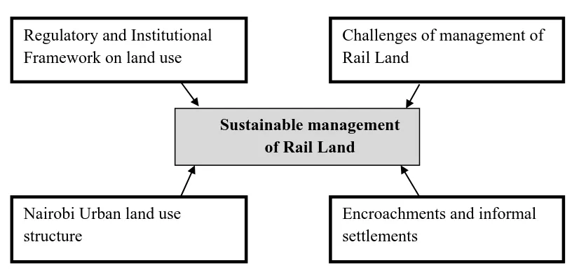
2.6 Conceptual Framework
According to Mugenda and Mugenda (2003) a conceptual framework is a graphical or diagrammatic representation of the relationship between variables in a study. In this study, the conceptual framework will be based on three independent variables that will guide the research’s review of literature and are presented in the diagram below.
Figure 2.1: Conceptual Framework
Source: Author, 2014
Challenges of management of Rail Land
Sustainable management of Rail Land Regulatory and Institutional
Framework on land use
Nairobi Urban land use structure
15
CHAPTER THREE: AREA OF STUDY 3.1 Physical set up
3.2.1 Location and extent
The study is based in Nairobi County which is located at the south-eastern end of Kenya’s agricultural heartland, at approximately 1° 9’S, 1° 28’S and 36° 4’E, 37° 10’E. It occupies an area of about 695km2 and the altitude varies between 1,600 and 1,850 metres above sea level (KNBS, 2010).
Plate 1: Location of Nairobi County
Source: Kenya Mpya, 2012
The study will further assess the area covered by the Nairobi commuter railway service that runs four commuter trains operating in the Nairobi Metropolitan Area from the centre of Nairobi Central Station as under:
16
Nairobi – Embakasi Village via Makadara (12.6 km) Nairobi – Kikuyu via Kibera, Dagoretti (31 km) Nairobi – Ruiru (32 km)
Plate 2: Master Plan for Nairobi Commuter Rail Development
Source: Kenya Railways Corporation (http:/www.KenyaRailways.org.ke)
The Nairobi commuter rail line was first built with the intention of connecting Thika and Nairobi, mainly by channeling heavy and bulky manufactured goods to Nairobi. The line was first mainly used for freight purposes before the introduction of heavy trunks on the road. When there was massive competition from road transport coupled with lack of political will, freight services became crippled to an extent that there was no container being ferried through the line. Because of this, the corporation introduced passenger rail services between Thika and Nairobi. 3.2.2 Topography and drainage
17
1991). Key physical features include the Nairobi, Ngong and Mathare rivers and the indigenous Karura forest in northern Nairobi. The Ngong hills stand towards the west, Mount Kenya towards the north and Mount Kilimanjaro towards the south-east. As Nairobi is adjacent to the Rift Valley, minor earthquakes and tremors occasionally occur.
Plate 3: Road and rail drainage during rainy seasons
Nairobi’s main drainage follows the regional slope of the volcanic rocks towards the east, while subsidiary internal drainage into the Rift region is confined to the western part. The lava plains east of the line Ruiru-Nairobi-Ngong are underlain by a succession of lava flows alternating with lakebeds, streams deposits, tuffs and volcanic ash. These plains, comprising mainly the Athi plains and the northern section of the Kapiti plain, extend westwards, rising from 4900 feet (1493 m) at the Athi River to 6000 feet (1829 m) in the faulted region near Ngong. The lava plains are crisscrossed with steep-walled gullies and canyon-like gorges, such as those along the Mbagathi valley. Further east this valley widens slightly where soft material is being actively eroded (Saggerson, 1991).
3.2.3 Climate
18
Nairobi and its environs towards Thika and the Central Highlands could be anywhere in the range of 500 to 1500 mm, with the average ringing in at 900 mm. Winds along the surface are predominantly easterly throughout the entire year. They are shifted to northeast between October and April, and they are shifted southeast between May and September.
3.3 Ecological set up 3.3.1 Agro ecological zones
The agricultural sector within the boundaries of the Nairobi Railway commuter service has industries such as coffee processing, fruit canning and juice extraction, flour milling, processing of tobacco products and many others.
3.3.2 Vegetation
The agriculture activities that are practiced within the jurisdiction of the railway include horticulture (exports mainly to Europe) and coffee industry (exports mainly to the USA and Europe). Other forms of vegetation include cotton, pineapples, macadamia nuts and wheat. 3.3.3 Wildlife
Nairobi is host to the only animal park within a city. The Nairobi National Park is a major rhino sanctuary, supports the second largest animal migration after the Masai Mara, and is a dry season refuge for most wildlife. The benefits of the park include recreation, environment education, employment and income generation.
3.4 Economical set up 3.4.1 Agriculture
The agricultural sector within the Nairobi County has industries such as coffee processing, fruit canning and juice extraction, flour milling, processing of tobacco products and many others. 3.4.2 Trade, commerce and industries
19
commuter line have many large and small shops. The building construction industry along the rail line is also quite active.
3.5 Social set up
20
CHAPTER FOUR: RESEARCH METHODOLOGY 4.1 Introduction
There is a strong relationship between transportation and land use. The intensity and location of different types of land uses affects the form of the roads, transit, walking and cycling networks that serve those areas and in turn, travel behaviour. Similarly, the characteristics of the transportation system and its relationship to the built environment have a significant impact on land use, the environment, economy and overall livability of communities. It is essential that planning and decision-making for land use and transportation be carefully integrated to support one another.
This chapter describes the overall methodology, data-collecting and analysis techniques that were employed in the study. It comprises the rationale for the research design and various sampling methods that were used to provide a fair presentation of those persons with information on the Nairobi Commuter Rail network especially those in direct operational and management of the Commuter Rail Network.
4.2 Research Design and location of the study 4.2.1 Research Design
This study sought to to empirically investigate ways through which sustainable management of Rail Land can be met within Nairobi commuter rail network. Mixed research methods were employed in this study: a qualitative data collection and analysis was selected to gather data from policy makers because it uses a naturalistic approach to understand an occurrence or phenomenon (Hoepfl, 1997). As well, a quantitative data collection and analysis was employed to explore more broadly the parameters of sustainable land management from the general public and stake holders in the commuter railway network.
21
data consisting largely of words or text from participants, describes and analyses these words for themes, and conducts the inquiry in a subjective biased manner”. Lichtman (2006), Sarantakos, and Patton (2002) point out that over the last twenty years, qualitative research increased in popularity in the field of education research; it is used to gain insight into people's attitudes, behaviours, value systems, motivations, culture, or lifestyles, and it is used to shape business decisions, policy formation, and communication.
On the other hand, quantitative research is a type of educational research that relies on the collection of data subject to quantitative analysis. It is generally a means for testing objective theories by examining the relationship among variables (Creswell, 2009; Johnson & Christensen, 2004). The researcher in quantitative research often “decides what to study, asks specific, narrow questions, collects quantifiable data from participants, analysing these numbers using statistics; and conducts the inquiry in an unbiased, objective manner” (Creswell, 2008, p.46). Hoepfl (1997) explains the two paradigms thus: where quantitative researchers seek causal determination, prediction, and generalisation of findings, qualitative researchers seek instead illumination, understanding, and extrapolation to similar situations. Qualitative analysis results in a different type of knowledge than does quantitative inquiry. Both forms of analysis were used in this study to gather adequate data and to enrich its findings and conclusions.
4.2.1 Qualitative and Quantitative Research
When considering the views of Ministry of land policy makers who influence the management of land, qualitative data collection such as that from interviewing were found to be appropriate for this study. Sarantakos (2005) and Patton (2002) both argue that qualitative analysis is an appropriate approach when flexibility is required for an in-depth study, and when attempting to understand a little-known phenomenon. Qualitative research seeks out the “why,” not the “how” of its topic, through the analysis of unstructured information, using interview transcripts and recordings, notes, and various forms of feedback (Creswell, 2009).
22 4.2.2 Mixed Methods
In this study, the research strategy of integrating different methods was used to produce better results in terms of quality and scope. A mixed methods approach can extend the analysis, findings and conclusions of a study to better inform its results and create a stronger path towards a critical evaluation on ways through which sustainable management of Rail land can be met within Nairobi commuter rail network and become more useful and accountable to a wider audience.
4.3 Target population and Sample Selection
The target population for the quantitative research was the general public and stake holders while the target population for the qualitative study was the land officers. The sample size is an important feature of any empirical study in which the goal is to make inferences about a population from a sample. In practice, the sample size used in a study is determined based on the expense of data collection, and the need to have sufficient statistical power Kish, (2005).
This study adopted stratified random sampling procedure to select the study respondents whereby the strata were composed of different members of public found in various commuter railway stations. For the qualitative study purposive sampling was used to select a sample of at least 5 land officers from the Ministry. This study used a sample of 385 respondents as calculated below.
For this study commuter rail stations were treated as strata to ensure that the data captured represents views of respondents across. The researcher randomly selected equal number of respondents from each stratum (station). The following formula (Fisher’s) was used to determine the sample size. When using this formula the study involved statistical assumptions that the selection of individuals was random and unbiased. The decision to include an individual in the study cannot depend on whether or not that individual had the characteristic or outcome being studied (Pagano , Gauvreau, 2000).
23 pq Z N e pqN Z
n 2 2
2
) 1
(
……….Since N is large
n = 385
P = 0.5, q=0.5, Z0.025=1.96 , e=0.05 Where e= Expected error n = sample size N= entire Population (large)
Z= level of significance
p = Probability that individual has the characteristic or outcome being studied
q = Probability that individual does not have the characteristic or outcome being studied 4.4 Research Instruments
The data collection instruments included an interview guide for the land policy makers and a questionnaire for the general public. This study also used semi-structured interviews as a means to collect data, because, as May (2001) points out, this form of interview is considered the most appropriate communication method because it provides both some control and flexibility during discussion which helps to elicit valid responses from the interviewees. Williamson (2002) argues that the semi-structured interview is closer to the unstructured in-depth interview than to the structured standardised form and it has a standard list of questions, but allows the interviewer to follow up on leads provided by participants for each of the questions involved. The use of semi-structured interviews in this study allowed a broad range of questions to be directed to policy makers to address the research aims.
4.5 Pilot Test
24
questionnaire. Mugenda and Mugenda (2003) posited that 1-10% of the sample size is subjected to pilot study and should not be included in the sample.
4.5.1 Validity
Face validity expert judgmental procedure of assessing validity was employed. This involved requesting professionals or experts in the Land administration field to review the questionnaire and give suggestions. Two (2) scholars from Kenyatta University (KU) were requested to fill in the questionnaires. They evaluated the construct of the instrument to assess and determine whether the set of items accurately represented the concepts. Their feedback was used to improve the research instrument.
4.5.2 Reliability
The study used the Cronbach’s alpha (α) to test for reliability. It indicates the extent to which a set of test items can be treated as measuring a single latent variable (Cronbach, 2001). The recommended value of 0.7 will be used as a cut-off of reliabilities. Cronbach’s alpha is a general form of the Kunder-Richardson (K-R) 20 formulas used to access internal consistency of an instrument based on split-half reliabilities of data from all possible halves of the instrument. It reduces time required to compute a reliability coefficient in other methods. The Kunder-Richardson equation of reliability
KR20= ( )( 1)
) )(
( 2 2
K S s S K ... .Equation 2KR20 Reliability coefficient of internal consistency K Number of item used to measure the concept S2 Variance of all score
25 4.6 Data Collection methods
To undertake the survey, permission was obtained from the Kenyan education authorities and Kenyatta University.
4.6.1 Interviews with Policy Makers
An interview procedure was used to gather information, perceptions, and (indirect) guidance for the survey questionnaire from decision makers who have responsibility for Land policies in Kenya.
4.6.2 Public Questionnaire
Data collected during the mixed methods research of the study comprised qualitative data that was generated through semi-structured interviews and quantitative data which were obtained through a questionnaire for the general public.
4.6.3 Data Analysis 4.6.3.1Qualitative data
Data analysis in qualitative methods can occur during data collection. Sarantakos (2005), Wiersma and Jurs (2005), and Creswell (2009) indicate that in many qualitative methods, some analysis of data occurs as it is collected, so that collecting and analysing data comes together in the same process. Sarantakos concurs, that analysis can take place during and after data collection in interviewing: analysis during data collection is the most common practice and the one that is most consistent with the principles of qualitative analyses. In this case, data was collected, coded, conceptually organized, interrelated, analyzed, evaluated and then used.
Moreover, analysis of the data during collection was important and plays a major role in the consistency of the findings of qualitative studies (Creswell; Lichtman, 2006; May, 2001). The qualitative data was analyzed using NVIvo.
4.6.3.2 Quantitative data
26
27
CHAPTER FIVE: DATA PRESENTATION AND DISCUSSION
5.1 Existing legal, statutory, regulatory and institutional framework affect the Nairobi Commuter Rail Land use
Railway transport is the second most important mode of transport in Kenya, after road transport, for both freight and passenger services. It is suitable for transporting bulky and heavy commodities over long distances. The Kenya Ministry of Transport and Infrastructure is responsible for managing policy for the transport sector in Kenya (including the sub-sectors of Roads, Maritime, Rail and Aviation), among numerous other functions.
The study finds that transport sector is governed by numerous statutes that fall under two broad categories, namely statutes affecting all sectors of the economy and sector-specific legislation. The different transport sectors operate under several transport Parastatals that operate under their specific statutes and are also subject to the State Corporations Act. The Kenya Railways Corporation (KRC), a parastatal created by the Kenya Railways Corporation Act, provides railway transport services and is the main regulator of the sector. In addition, KRC provides inland waterways transport services and port facilities in relation to those services.
28
The GoK and KRC, under a concession agreement, leased the management and operation of railway services to RVR for 25 years and the operation and management of passenger services for 5 years from the Commencement Date of the Concession. The Kenya Railways (Amendment) Act 2005 made it possible for the KRC Board to enter into a concession agreement for the provision of railway transport services.
The law was amended through the Kenya Railways (Amendment) Act 2005 to make it possible for the board of directors to enter into concession agreements or other forms of management for the provision of rail transport services. Following this amendment, Kenya and Uganda entered an agreement in November 2006 to jointly concession the railway line from Mombasa to Kampala to a third party so as to increase efficiency. Consequently, Rift Valley Railways (RVR) took over the operations of the Kenya and Uganda Railways on November 1, 2006, on a 25-year concession.
Rift Valley Railways is owned by Rift Valley Railways Investments Pty Ltd, which is in turn owned by Kenya Uganda Railways Holdings (KURH). The current shareholding of KURH is Citadel Capital with 51 per cent ownership (Citadel is quoted on the Cairo Stock Exchange), Kenya’s Trans—Century Limited with 34 per cent ownership and Bomi Holdings Limited of Uganda with 15 per cent ownership. Bomi Holdings is an investment company owned by Ugandan entrepreneur, Charles Mbire who is a member of the Uganda Presidential Investment Round Table.
29
5.2 Challenges hindering sustainable management of Rail Land
Rail companies play an integral role in land management and their actions have the potential to affect many neighbours. The railway services in the country are provided by a private operator (RVR) and Magadi Soda Company whose services are limited to transporting its own products. The Railway Operator (RVR) provides inter-city passenger services and urban commuter services in Nairobi. The field study revealed a large business potential as evidenced by the level of dissatisfaction by commuters with the current service being offered by the railway operator as indicated below (see figure 1)
Figure 1: Satisfaction with current services
Source: Field Research, 2014
30 Source: Field Research, 2014
Figure 2: Preference for train services
In general the Railway service in Kenya faces a myriad of challenges that hinder sustainable use of the railway land. Some of the challenges identified by the study include:
Need for reconstruction of damaged railway sections and construction of new railway by-pass
Safeguarding of railway reserves in 76 stations during the concession period Container build-up at an average dwell time of 23 days
RVR relies on the 174 old locomotives taken over from KRC, of which only 55 are in running order
Stiff competition from road and pipeline transport
Tax policies that result in the railways subsidizing road transport, which is its major competitor, through payment of road maintenance fuel levy
An unreliable and ageing infrastructure and rolling stock particularly the single track, bridges, telecommunication, signalling and other facilities.
31 Source: Field Research, 2014
As depicted in figure above, it is evident that despite the good will the commuter service is currently enjoying from Nairobi residents, there are a number of challenges facing the management. The current demand for the service is overwhelming but the supply is constrained due to inadequate rail network within the Nairobi region. This problem is also compounded by few engines, which is note enough to meet the ever-increasing demand. This has in most cases caused serious congestion and some of the passengers who do not find space usually hangout thereby endangering their lives. The engines are also old which make them move at a slower speed compared to modern commuter services.
32
provide commercial services along such lines and routes with a view to ensuring their long-term sustainability.
The field study got key recommendations on the sustainable use of rail land as follows:
Ensure that adequate land for future development and operations is identified and reserved.
Ensure that existing land belonging to KRC is protected from further encroachment whereas the illegally lost land is repossessed.
Acquire additional land for development and expansion of railways infrastructure taking into account the planned modernization programme, demographic changes and changes in industrial and agricultural production and other economic activities.
Ensure that Nairobi and other major urban centres, such as Mombasa Nakuru, Kisumu and Eldoret incorporate in their development plans the need for the construction of railway networks for the operation of urban and peri-urban commuter trains.
On the policy intervention to sustainable land use by the railways Sessional Paper no. 3 of 2009 on National Land Policy is aimed at guiding the country towards efficient, sustainable and equitable use of land for prosperity and posterity. It provides the overall framework and defines the key measures required to address the critical issues of land administration, land use planning, restitution of historical injustices, environmental degradation, conflict resolution, proliferation of informal settlements, outdated legal framework, institutional framework and information management. The key principal in the policy that the railway system can use to its advantage is land use planning which is recognized as essential for the efficient and sustainable utilization and management of land and land based resources.
The Integrated National Transport Policy of 2003 also recommends transport planning that supports appropriate strategies such as national development, land use planning and efficiency, establishing transport infrastructure and services linking urban industrial centers, rural production zones and markets to induce robust socio-economic activity and growth.
33
with land use issues are equally numerous. Sector specific laws are deficient in that they are characterized by fragmented and uncoordinated sectoral legal regimes that are developed to facilitate resource allocation and to deal with environmentally adverse effects of resource exploitation. The sectoral institutions under these laws often find themselves in regulatory competition.
The Constitution of Kenya in spite of being the supreme law of the land does not contain specific provisions regarding the management of reserves. The Environmental Management and Coordination Act of 1999 (EMCA) was enacted to provide an appropriate legal and institutional framework for the management of the environmental and for matters connected therewith and incidental thereto. EMCA does not repeal the sectoral legislation but seeks to coordinate the activities of the various institutions tasked to regulate the various sectors. These institutions are referred to as Lead Agencies in EMCA. Lead Agencies are defined in Section 2 as any Government ministry, department, parastatal, and State Corporation or local authority in which any law vests functions of control or management of any element of the environment or natural resource.
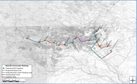
5.3 Relationship between Nairobi commuter Rail Land use and Nairobi Urban Land use structure
34 Figure 4: Map of Nairobi Commuter Rail Service
Source: Kenya Railways Corporation (http:/www.KenyaRailways.org.ke)
Nairobi is the capital and largest city in Kenya, previously known as the “Green City in the Sun”. In Nairobi, aspects of competitiveness are seen in the highly differentiated modes of travel ranging from 14-seats van Matatus to large 29-seats mini-bus and 51-seats buses that have different positioning strategies. The level of competitiveness among the transport providers is increased by the various strategies they adopt to attract commuters. The development of the Railway System is paramount to improving its competitiveness in the transport industry. This will require substantial improvements to the existing rail network, including the rail infrastructure itself and stations.
35
Table 1: Existing routes and services on the Nairobi Commuter Service
Route Peak Off-Peak
Dagoretti – Nairobi Hourly Hourly
Dandora – Nairobi Half-Hourly Hourly
Embakasi Village – Nairobi Hourly in the peaks (4 trains per day)
No Service
JKIA – Nairobi Half-Hourly Half-Hourly
Source: Field Research, 2014
There has however been significant developments in the Nairobi Metropolitan Commuter Service evident in the opening of the new Syokimau Station an construction on other stations within the commuter service line.
Plate 4: Ney Syokimau Station
36
Plate 5: Construction on Imara Daima and Makadara Railway Stations
There are several land users or occupants found within the 10.4m corridor. These range from residential households, tenants, business people and farmers. The reserve users have different assets ranging from structures, trees and crops. The RVR should make safety considerations of increasing reserve zones covering areas beyond the 10.4m corridor. These additional zones focus on level crossings and densely populated areas in which encroachment must be cleared. The additional zones, which exist beyond the 10.4m but are within the 60m reserve, necessitate clearance for resettlement purposes given the scale of encroachment that exists at the level crossings and in the densely populated areas. If left uncleared, these additional zones would further threaten community safety and compromise RVR operations.
4.4 Impact of encroachments and informal settlements on the Nairobi commuter Rail Land use
37
Plate 6: Encroachment of rail reserve in Kibera and Mukuru Slums in Nairobi
RVR operates a total rail network of 1920 kilometers countrywide. The main line runs from Mombasa at the coast to Malaba in the west. Typically, the railway line has an exclusive corridor (referred to as a reserve) 60.6 meters wide throughout the network except at station yards and major depots where a larger railway reserve is provided.
Despite the requirement to have a railway reserve free for railway operations and safety, parts of the railway reserve have evidently been encroached upon (See Picture 1). The railway reserve in both Kibera and Mukuru within the city of Nairobi is particularly encroached by large numbers of people who reside and/or carry out business within it. At several places on the railway reserve, markets have been established on both sides of the railway line. The line is used in these areas as a path for accessing the market stalls and by pedestrians moving to and from the city centre and the industrial area.
The human encroachment on the reserve has several serious consequences, among them:
38
Plate 7: Tracks in Nairobi old Makandara Station exposed to surfdace runoff
Risk to property in the event of accidents or derailments;
Dumping of waste onto the railway track which impedes track drainage and compromises track stability;
Exposure of maintenance personnel to unhygienic working conditions and disease due to disposal of faecal and other waste on the track;
Plate 8: Rail under bridge crossing with encroachments and garbage endangering both the rail and road transport
Slow train speeds which cause inordinate delay;
Limited profitability for the concessionaire due to inability to increase freight carriage by an increase in operational speeds.
39
valuable and occupied and as such very small portions are left to make provision for basic services such as sufficient foot paths, adequate sanitation, drainage and decent housing. The business structures on the reserve in Mukuru are in three rows of stalls built against each other parallel to the railway track. The row adjacent to the track is often comprised of mobile vendors who lay their commodities either on the ground, on a cart or hold/hang their commodities on their bodies. The track is used as the main footpath connecting all these Mukuru settlements to the main roads such as Mombasa Road, Jogoo Road, Lunga Lunga Road and Outer Ring Road and often the relationship between the mobile vendors and the pedestrians is abrasive as a result of competition for the same space. Successive rows in Mukuru house different kinds of businesses. The furthest row from the track comprises of textile shops, boutiques, footwear and kitchen utensils. The second row of businesses is slightly similar to the third row but with an addition of quick bargains or quick picks such as ready-to-eat food stuffs, pre-packaged fruits, handkerchiefs, air time, shoe laces etc. The mobile vendors often sell vegetables, miraa (khat), mobile phones/phone accessories, insecticides, socks, shoes, slippers etc. In addition, the mobile vendors also respond to demand and hence their temporary nature. During a rainy period for instance, an influx of mobile vendors is observed along the reserve engaging in selling umbrellas, plastic boots (gum boots) and protective head gear.
40
Plate 9: Relocation units under construction in Kibera
Presently, encroachment prevails across the railway reserve. RVR would at a minimum, require a clear operational corridor to permit the forecast train operations and to ensure community safety. The Kenya Concession Agreement and the Uganda Concession Agreement provide for the preparation of a Resettlement Action Plan (RAP) as the means of managing encroachment on the railway reserve in a planned and coordinated manner in Kenya and Uganda respectively. Kenya Railways Corporation proposed a relocation action plan of its own railway from Mukuru to Kibera railway station. The project scope entails the provision of relocation units, business stalls, footpath, overpass and underpasses on ten meter wide spaces on either sides of the railway reserve.
The railway reserve in both areas is particularly encroached by large numbers of people who reside and/or carry out business within it. Markets have been established on both sides of the railway line. The line is used in these areas as a path for accessing the market stalls and by pedestrians moving to and from the city center and the industrial area.
The legal and policy framework for compensation and resettlement that RVR can pursue is defined by the relevant laws and regulations of the Kenyan Government. The Main Pieces of Legislation Regarding Compensation and Resettlement Issues in Kenya are: The Constitution of Kenya (2010); Kenya Railways Corporation Act Cap 397 (as amended); Kenya Railways Corporation (Vesting of Lands) Orders 1986; The Kenya Land Policy (2007).
41
to occupants in good faith of land acquired under clause (3) who may not hold title to the land. Clause (3) in this case refers to compulsory acquisition of land. However in the same vein, clause (6) states that the consideration does not extend to those who acquired the property unlawfully.
Kenya Railways Corporation Act Cap 397 - The Kenya Railways Corporation (KRC) is the owner of the railway assets that were conceded in Kenya and is empowered by the Kenya Railways Corporation Act Cap 397 (as amended) to enter into the Concession Agreement with the concessionaire. The railway reserve is vested on the Kenya Railways Corporation (KRC) for the Government of Kenya (GOK). Rift Valley Railways as the concessionaire also has a stake on the railway reserve.
42
CHAPTER SIX: SUMMARY OF THE FINDINGS, CONCLUSION AND RECOMMENDATIONS
6.1 Summary
The railway network in Nairobi is not well integrated with major urban centres within the county and other neighbouring counties. The current railway track is old and unreliable and from observation has sharp curves and high gradient in certain sections that limit train speeds and haulage. The telecommunication and signalling systems used for train operations are also been explained as old and unreliable. The current infrastructure in its present state cannot be expected to fully provide effective services to industry and people and to contribute to national and regional economic development.
There also exists a policy and legal enforcement gap to address and regulate the land use activities along the railway. Current legislation does not provide sufficient legal framework to support and protect reserves because of various intertwining legislation that limits the main regulator, the KRC from reclaiming and putting into good use the existent rail reserve. Most reserves have been used for small scale agriculture. Equally there is no clear policy on sustainable use of rail land within the Nairobi Commuter rail network.
For many years, the KRC had also not undertaken any major development either through rehabilitation and upgrading of its infrastructure, construction of new lines or modernization. Leading to accumulation of a substantial backlog of investments in both rehabilitation and upgrading of its infrastructure. This informs the rationale behind the concessioning of KRC operations to private operator.
43
existing modes. The development of infrastructure will inevitably require the participation of the private sector.
6.2 Conclusion
The city of Nairobi is experiencing massive city growth and development. The same is not accompanied by effective transportation system. This has led to very poor quality of transport service in the city.
The existing railway infrastructure in Nairobi generally consists of old and outdated technology while the economic lifetime for most of its existing infrastructure, locomotives, rolling stock and equipment will expire in the next 10 to 20 years. Most other railways in the world of this generation, or younger have embraced modern technology and undergone tremendous changes, including the adoption of the standard gauge railway systems, in order to meet the critical challenges posed by increased developments in production, trade and tourism. The government must therefore immediately take a holistic longer term view of the railway system and start preparing for the modern new railway now, given that world-wide, this transport mode has proved to be the most-cost-effective for bulk freight and passengers over long and short distances, besides being also the most environmentally-friendly.
6.3 Recommendations
6.3.1 Short Term Recommendations
The KRC should recognize the importance of relevant and necessary programs and initiatives that can increase the share of commuters in Nairobi such as fare discounts and marketing of the commuter services.
Promoting adoption of alternative sources of income for reserve land users encouraging start of businesses and self help groups
Education and awareness creation on importance of rail reserve land and why it should be left unoccupied