By
Rolf W. Feyling-Hanssen
University of Oslo
Abstract.
A correlation chart is presented containing the stratigraphical results of some selected Norwegian studies in the wide field of Quaternary geology. Studies of plant remains in bogs, pollen investigations, evidence of transgressions, shoreline displacement, registered by isolation of troughs from the sea during isostatic rise of the land mass, have all contri buted to the columns of the chart. Furthermore, shoreline stages based upon occurrence of marine Mollusca in littoral sediments in Norwegian localities as well as in Spits bergen, clay deposits in the Oslofjord area, subdivided by their content of marine Pelecypoda and Foraminifera, marginal moraine substages in southern Norway and in the northernmost part of the country have been plotted. A curve illustrating the variation in the height of the fim line in western Norway is also inserted.
Introduction.
The Blytt-Sernander sequence, which is to be found in the left part of the correlation chart, here presented, is assumed to be known to students of the Holocene all over the world, and may serve as an international standard to which the less known specific Norwegian columns can be referred. As an other international standard the Danish pollen analytical zone system, proposed by Knud Jessen (1935, 1938), is inserted and closely related to the modified Blytt-Sernander sequence. For the same purpose of international correlation the well-known terminology pro posed by Gerard de Geer (1912), based upon studies of varved clay
1 This article appears also in volume 139 of the Transactions of the Institute of Arctic Geology, Leningrad, 1964.
.i x T >y 64° V
/
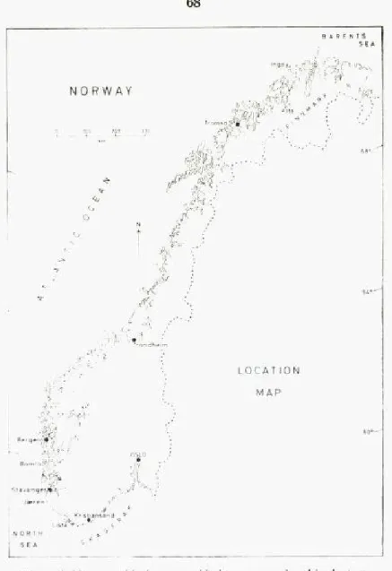
LOCATION MAP 4 i "'""it? 60°" OSLO Ri-' '-' ''-. M'l^ avang.r»^ Jaere.
NORTH v f SEAFigure 1. Norway, with the geographical names mentioned in the text.
chronology in Sweden, is to be found in the chart. De Geer used the terms Late Glacial and Post Glacial in a different way than the pollen stratigraphers use them to-day. The latter usage is found on the left side of the Blytt-Sernander sequence in the chart. In that column is also indicated the Post Glacial Warm Interval, in the concept of, i. a., Firbas
rf*
)\
(1954), which is the same as the Postglacial Hypsithermal Interval of Deevey and Flint (1957), embracing the Boreal, Atlantic and Sub-Boreal of Blytt-Sernander (cp. Gams and Nordhagen, 1923, p. 293). The term Post Glacial Warm Interval proper is narrower, comprising only Atlantic and Sub-Boreal time.
To the left in the chart are listed the Late Quarternary epochs Pleisto cene and Holocene. In accordance with general use (Cp. Woldstedt, 1954, p. 2) the borderline between the two epochs in the chart coalesces with the border between Younger Dryas and Pre-Boreal, i.e., the border bet ween Late and Post Glacial in the concept of pollen stratigraphers.
The different zone borders in the chart have, if possible, been related to the absolute time scale under consideration of available radiocarbon datings (i. a., Gross, 1958; Radiocarbon Supplement, vol. 1, 1959, vol. 2, 1960; Radiocarbon, vol. 3, 1961, vol. 4, 1962). As to the dates for the pollen zone boundaries 11/111, I/11, Ib/Ic, and la/Ib see especially Tauber (1960 a and b). For classifications not treated in the present short review, the reader is referred to Holtedahl's "Geology of Norway" (1960) or his "Norges Geologi" (1953) of which a Russian edition appeared in 1958. The writer is grateful to Mrs. Kari Henningsmoen, The University of Oslo, and Dr. J. D. de Jong, The Geological Survey of Holland, who read the manuscript. He is also indepted to Dr. B. G. Andersen and Mr. M. Marthinussen, University of Oslo, who offered valuable sugges tions about certain transgressions and moraine substages.
Pollen zones.
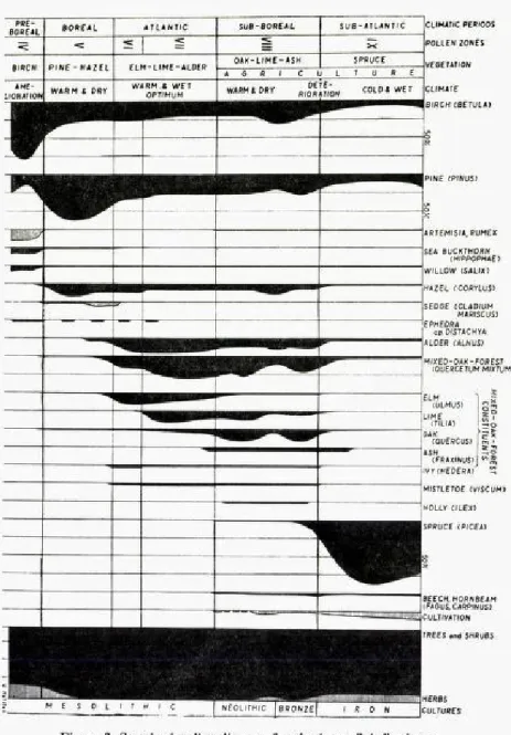
Fægri (1940, 1944,1953) investigated the Late Quaternary development of vegetation and climate in two localities in south-western Norway, viz., the flat, moraine-covered coastland of Jæren south of Stavanger, and the rock island of Bømlo, between Stavanger and Bergen. Jæren was ice-free already in Late Pleistocene time.
Mainly from studies of size and morphology of Betula and Salix pollen Fægri recognized a series of Late Glacial climatic oscillations, zones I-VI in his designation. The lowermost samples were dominated by willows {Salix herbacea) and grasses. The subsequent development was charac terized by a rapidly increased content of dwarf-birch pollen in the samples, and then by appearance of large-leaved birches. During zone VI (Jessen's zone III), Younger Dryas time, tundra conditions were rein troduced with heath (Empetrum), grass (Graminae) and sedge
(Cyper-CCIMATIC PERIOOS POLLEN ZONES
VEGETANON
COLO* WET CLIMATE BIRCH CBETUL4) PINE (PINUS) ARTEMISIA, RUMEX SEA BUCKTHOP.N CH/PPOPH4E) WILLOW (SAL/X) HAZEL fCOffrLUS) SED6E CCLADIUM MARISCUS: EPHEDRA MARISCUS) cp. DISTACHYA ALDER (ALNUS) MIXED-OAK-FOREST (OUERCETUM MIXTUM) 2 curn (ULMUS) gS LIME *? (TILIA) I 20 OAK fQUERCUS) m ' ASH :*O (FRAXINUS)j ""^ IVr(HEOERA) MISTLETOE (WSCUM) HOLLr C/LEX) SPRUCE (PICEA) BEECH. HORNBEAM (FAGUS. CAftPINUS) iCLJLTIVATION
TREES and SHRU6S
CULTURES Figure 2. Standard pollen diagram for the inner Oslofjord area.
aceaé). During Pre-Boreal time, characterized by the so-called Fini Glacial climatic amelioration, the dwarf-birch tundra was replaced by birch forests dominated by silver birch (Betula verrucosa). Due to violent melting the margin of the inland ice rapidly receded in still glaciated areas, and simultaneously an isostatic uplift took place at considerable rate. This is illustrated in the column of shoreline displacement at Oslo (Hafsten, 1956, 1959, 1960). A vegetation of heliophilous and rather thermophilous herbs and shrubs occupied such newly emerged areas during Pre-Boreal time. An abrupt change in vegetation took place at the transition to Boreal time. Pine (Pinus silvestris) and Hazel (Corylus avellana) to some extent replaced the birch, and the land was much more densly forested (Hafsten 1960). Cladium mariscus, known from three localities in Norway, dates back to the beginning of Boreal time. The mixed oak forest culminated in eastern Norway already during Atlantic time, in western Norway, however, during Sub-Boreal time. Other con stituents of the vegetation development support the view that the climatic optimum in eastern Norway occurred in Atlantic time, whereas in western Norway it fell in Sub-Boreal time (Hafsten, 1960). Misteltoe (Viscum) seems to have had a continous distribution from the Mjøsa region, north of Oslo, along the south coast to Jæren. Water chestnut (Trapa natans) from Atlantic and early Sub-Boreal time has been found on both sides of the Oslofjord. - With Sub-Atlantic time a profound climatic deteriora tion took place. The sensitive trees were replaced by more hardy species, predominantly spruce (Picea abies). In the Oslofjord region this expansion of spruce was almost explosion-like (Hafsten, 1960).
The pollen analytical zone system of Jessen is now in general use among Norwegian pollen stratigraphers.
The earliest traces of man in Norway are Mesolithic reaching back into Boreal age probably even into Pre-Boreal. The Komsa culture in Finn mark, northern Norway, and the Fosna culture in western Norway belong here. Either of them are hunting cultures (Cp. Nummedal, 1924; Bøe and Nummedal, 1936). The younger Nøstvet culture extends into Sub-Boreal age (Brøgger, 1905). Agricultural land occupation dates back to the Atlantic/Sub-Boreal transition, and was probably introduced into southeastern Norway by immigration of a southerly farming population during the Danish Dolmen age (Hafsten, 1960, p. 459).
Shoreline displacement.
Phenomena proving displacements of the shoreline during the Quater nary period, especially during the Late Pleistocene and Holocene epochs, have been studied and discussed in Norway for more than one hundred years. A considerable number of observations and measurements have been brought together. A recent review of the activities in this field was given by Holtedahl (1960, p. 369) in his "Geology of Norway".
Hansen (1890, 1900) connected the problem of shoreline displacement with the ice-pressure theory of Jamieson (1865), and many papers dealing with shoreline displacement, positive and negative, as resulting from isostatic readjustment appeared, e. g., Helland (1900). Holmsen (1918) and Nansen (1922) brought into the discussion the importance of eustatic changes of sea level. These ideas formed the foundation for the compre hensive, wellknown shoreline studies carried out by the Finish geologist Tanner in northern Fennoscandia (e. g., 1930), and for similar studies in northern Norway by Grønlie (1940) and Undas (1938). The results of these investigations are not incorporated in the present correlation chart. During many years Marthinussen (1945, 1960) studied shorelines in Finnmark, northern Norway. He separated three groups within the series of marine levels: Late Glacial lines, designated by S, Post Glacial lines, P, and Neo Glacial lines, N. In the correlation chart a few of these lines are listed. The designation Tapes, I-IV, has been used instead of N 9-N6, and none of the P lines are plotted, except Pl2which is synonymous with SOy the so-called main line. The lines are placed in the column according to their age, which has been radiologically determined by the aid of marine shells from corresponding deposits. As illustrated by the chart, some lines correspond to marginal moraine stages, others to periods of trans gression. To the right of the column with the transgressions is given the shoreline displacement for two localities in Finnmark, one outer, more periferal, the island of Ingøy, more than 71° n. lat., 24° e. long., and one situated, more centrally, Alta, 70° n. lat., 23° e. long. The more rapid land elevation toward central areas is clearly illustrated. The main line So, is on Ingøy situated approximately 2 m above present-day sea level whereas in Alta it is found 75 m above sea level.
In the Trondheim region, central Norway, and the Oslo region, south eastern Norway, Øyen (i.a., 1903,1915) established a system of Holocene
shoreline stages based upon occurrence of certain littoral molluscs in shore deposits. He found the highest marine limit at Skaadalen, Oslo to be 221 m above present-day sea level, characterized by Mytilus edulis. A sample of Mytilus shells from shore gravel at that locality, submitted by H. Rosendahl, was radiologically dated at 9680 i 250 years before present (1950). The dating was carried out by R. Nydal of the Radio logical dating laboratory in Trondheim. Successive lower stages in the shoreline displacement were named: Portlandia stage {Portlandia arctica, a small form), Littorina stage {Littorina littorea), Pholas stage (Barnea candida), Mactra stage (Spisula solida var. elliptica), Tapes stage (Tapes decussatus), Trivia stage {Trivia arctica), Ostrea stage (Ostrea edulis) and Mya stage, Recent {Mya arenaria). In the column for this system in the chart, an effort is made to place the borderlines between the stages in accordance with the heights given by Øyen. Øyen supposed a transgression to have taken place at the beginning of each stage in his system. It has not been possible to verify the existence of such transgressions by later studies. For this and other reasons Øyen's system was heavily critisized by Holtedahl (1924) and Hessland (1943). Short reviews of it are given by Feyling-Hanssen (1957, p. 16, 17) and Holtedahl (1960, p. 382-385). In southwestern Norway, Bømlo and Jæren, Fægri (1940, 1944) traced the Late Quaternary displacement of the shoreline by pollen-analytical investigation of bog basins at different heights above present-day sea level. His results, with displacement diagrams, are summarized by Haf sten (1960, p. 453-458). In Bømlo Fægri estimated a marine limit at 32 m above present sea level, whereas in central Jæren it was situated at a height of 9 m. Both places three transgressions, intervals with a positive shift of the shoreline, were found to have taken place, one Late Pleistocene and two Holocene. The Late Pleistocene one, called the Alvevann trans gression, seems to be slightly older than the Allerød interstadial. Andersen (1960, p. 97) assumed this transgression to have taken place in Bølling time, accordingly it is placed at Bølling level, with a " ?", in the column for transgressions in Southwest Norway in the chart. Andersen (1.c.) re corded a Late Pleistocene transgression from the Norwegian south coast, west of the city of Kristiansand, this is assumed to be of Allerød age.
Of the two Holocene transgressions recorded by Fægri, one occurred in Atlantic time, the other one at the transition between Atlantic time, the other one at the transition between Atlantic and Sub-Boreal. He estimated the total eustatic rise of sea level between the Boreal regression
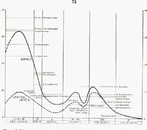
Figure 3. Diagrammatic representation of the Late Quaternary shoreline displacement in Jæren and Bømlo, constructed on the basis of Fægri's results (1940 and 1944).
From Hafsten, 1960.
minimum and the Sub-Boreal transgression maximum as 8-9 m. Gabri elsen (1959, p. 1616-1617) found a transgression at Mandal, South Nor way, to have started approximately 8800 years ago (Cp. Hafsten, 1958; Andersen, 1960, p. 98).
In the Oslo area, Southeast Norway, the Holocene shoreline displace ment was investigated pollen-analytically by Holmsen (1920) and Hafsten (1956, 1959). There the shoreline shifted from 221 m above present sea level to its present position without any positive oscillations. The isostatic component in the relative movement outrivalled the eustatic one during the whole epoch. As seen from the height figures plotted in the chart {Shoreline displacement at Oslo), the shift was much more rapid during the older part of the Holocene than in the younger part of the epoch.
15°
79°
78°
77
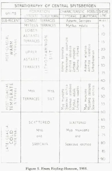
It decreased from lim per century in Pre-Boreal time to 0.37 m in Sub-Atlantic time. Two thirds of the Holocene shoreline displacement had taken place before the beginning of Atlantic time (Hafsten, 1960, p. 457). For the Billefjord and Kapp Wijk in central Spitsbergen Feyling-Hans sen (1955 a, b) established a Late Quaternary stratigraphical sequence based on studies of raised shorelines and fossil shells of marine molluses and cirripeds in the deposits. Shorelines of marine origin were found up to 90 m, in the near-by Sassenfjord even up to 96 m, above present sea level. Marine shells were found up to 84,5 m a.s.l. Changes in faunal
position during a general negative shift of the shoreline made the following subdivision possible:
The Late Glacial Cold interval comprises the time in which the shore line in the Billefjord moved from 90 m to 60 m above present day sea level. Only two species of marine molluscs were observed in the corre sponding deposits, viz. Saxicava (Hiatelia) arctica and Mya truncata, only scattered shells and fragments occurred.
The Post Glacial Temperate interval comprises the time during which the shoreline moved from 60 m to 40 m above present sea level. 14 new species (11 molusc species, 1 cirriped, 1 echinid and 1 calcareous algae) occurring in the corresponding deposits, among them Chlamys islandica, Mytilus edulis, Serripes groenlandicus, Macoma calcarea, Littorina saxa tilis, Balanus balanus. The fauna suggests that the marine-climatic condi tions of that interval were slightly more favourable than those prevailing in the area to-day. As the fauna of the terraces between 60 m and 40 m a.s.l. are predominated Mya truncata, these terraces were called Mya terraces. The Post Glacial Warm interval is the period in which the shoreline in the Billefjord moved from 40 m to 3 m above present sea level. According to occurrences in the corresponding deposits 39 new species of molluscs and cirripeds immigrated to the inner Isfjord area during that period, among them 7 which now seem to be extinct in Spitsbergen waters, viz. Heteranomia squamula, Modiolus modiolus (= Volsella modiolus), Arctica islandica (= Cyprina islandica), Zirfaea crispata, Emarginula fissura, Littorina littorea, Omalogyra atomus. Consequently the marine-climatic conditions were decidedly better than those prevailing there to-day, pro bably similar to those now prevailing along the coasts of Finnmark and Iceland. As the fossil fauna of the littoral deposits between 40 m and 6 m a.s.l. is predominated by Astarte borealis, the terraces within that height interval were termed Astarte terraces. They were further divided into Upper Astarte terraces, from 40 m to 17 m a.s.l. and Lower Astarte terraces, from 17 m to 6 m a.s.l. Between 6 m and 3 m a.s.l. there occur littoral features which were termed Mytilus terraces, because Mytilus edulis predominates in most of them.
The Sub-Recent interval is the time in which the shoreline moved from 3 m a.s.l. to its present position. At these levels the Warm interval indi cators have disappeared from the fossil fauna; even Mytilus edulis seems to have abandoned Spitsbergen waters. In very recent time this species seems to have reoccupied the area. A severe deterioration of the climate took place during the Sub-Recent interval.
Figure 5. From Feyling-Hanssen, 1955.
These stratigraphical units of central Spitsbergen were correlated with the Late Quaternary horizons recognized in West Greenland by Laursen (1950): The Post Glacial Warm intervaloi central Spitsbergen corresponds to the Horizon F of West Greenland as proved by the occurrence of equivalent "warm" indicators in the fossil faunas of the two areas. Deposits with Mytilus and Astarte in King Oscar Fjord in East Greenland (Noe-Nygaard, 1932) also belong to that interval. The Post Glacial
Temperate interval of central Spitsbergen corresponds to the Horizon E in West Greenland and to deposits with Chlamys, Mytilus, Saxicava (Hiatella) and Mya in East Greenland. In all the three regions Mytilus edulis appears for the first time in these deposits. The Late Glacial Cold interval in central Spitsbergen is correlatable with Horizon D and C, probably also Horizon B and D of West Greenland. In the King Oscar Fjord area of East Greenland the only fossils found above the Mytilus bearing deposits were Saxicava {Hiatella) arctica and Mya truncata, i.e., a fauna uniform with that of the Late Glacial Cold interval in central Spitsbergen.
Radiocarbon datings of some shells from the Late Quaternary deposits of the Billefjord (Feyling-Hanssen and Olsson, 1959-1960) revealed that the main trend of the negative shift of the shoreline during the Holocene epoch in central Spitsbergen is very similar to that of the Oslo region, for example. There was an early part with rapid displacement, more than 2 m per century, and a late part in which the rate was less than a tenth of this. The rapid displacement occurred in Pre-Boreal and Boreal time. Similar shoreline displacement, similar in aspect, not in magnitude, were found in Nordaustlandet (the North-East Land) in Spitsbergen (Blake, 1960, Olsson and Blake, 1961) in Franz Joseph Land FpocßajibA (Gros vald), JJeßiipn, (Devirtz) and (Doskina), 1961), in northern Canada (Farrand, 1962) and in Northeast Greenland (Washburn and Stuiver, 1962).
According to radiocarbon datings of samples of peat layers, one from Barentsøya (the Barents Island) and one from Skansbukta in the Bille fjord, marine transgressions seems to have occurred in Spitsbergen, one 6 000 years and the other 4 800 years before present. (Feyling-Hanssen, 1964, in press). The samples were dated by I. Olsson (Cp. Olsson, Cazeneuve, Gustavson, and Karlen, 1961).
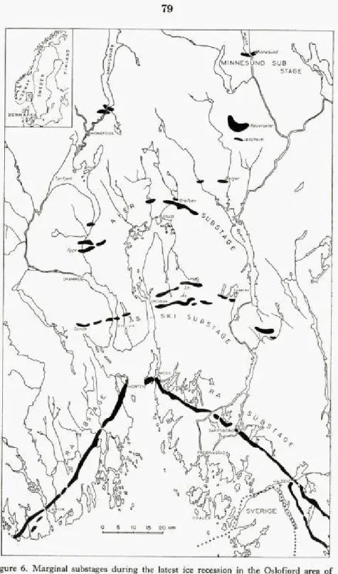
Marginal moraine substages.
The recession of the latest inland ice in the Oslofjord area northwards to the great lakes of Southeast Norway has been investigated during more than one hundred years, i.a., by Keilhau (1838), Kjerulf (1871), Brøgger (1900-1900), Holtedahl (1924, 1960), Holmsen (1951). A series of marginal substages has been traced, the most prominent one being represented by the Ra ridge. This ridge has been followed, almost con tinuously from the Swedish border to Moss, on the east side of the outer
Figure 6. Marginal substages during the latest ice recession in the Oslofjord area of southeastern Norway. Redrawn from Holtedahl, 1953. From Feyling-Hanssen, 1957.
Oslofjord, from Horten, on the west side, to Jomfruland (Hansen, 1910), and from Arendal across southern Norway to the fjords east and north east of the city of Stavanger (Andersen, 1954, 1960). This moraine sub stage, the so-called Fennoscandian, is assumed to be of Younger Dryas age. A sample of fossil shells from marine sediments at Valle on the east side of the Oslofjord, supposed to have been deposited when the ice margin lay along the Ra line, has been radiologically dated at 10 700 i 300 years before present (1950). A sample of shells from marine clay lying within the Ra ridge, at Larvik, was dated at 11 000 i 250 years before present (samples submitted by Feyling-Hanssen, and dated by R. Nydal of the Radiological Dating Laboratory in Trondheim, cp. Nydal, 1962, p. 170).
Two older moraine substages are known to the south of the Ra ridge on both sides of the Oslofjord, viz., the Tjøme-Hvaler substage and the Tjølling-Slagen-Onsøy-Borge substage. They are not inserted in the correlation chart. From the Norwegian south coast Andersen (1960) recorded marginal moraines of three glacial substages older than the Ra substage, the oldest one being the Lista substage, which he supposes to be of Oldest Dryas age. The Spangereid substage is supposed to originate from the youngest part of Oldest Dryas time, and the Kristiansand sub stage probably from Bølling-Older Dryas.
Of the two moraine substages younger than the Ra substage, moraines of the Aker substage are found, i. a., in the northern outskirts of the city of Oslo. The previously mentioned sample of Mytilus shells from littoral deposits corresponding to this substage (p.o) radiologically dated at 9680 i 250 years before present indicates that the margin of the inland ice of the latest glaciation receded from the Ra moraine to the moraines of the Aker substage, in the Oslofjord district, a distance of 60 km, in less than 500 years. The Ås-Ski substage was geochronlogically (varved clay chronology) dated at 9940 years before present (E. H. de Geer, 1962). - The ice recession further northwards, between Oslo and the southern end of the lake Mjøsa, was traced by Holtedahl (1924) mainly by investigation of marginal deltas and terraces.
In Finnmark, North Norway, Marthinussen (1961) has mapped mar ginal moraines over long stretches and has recognized three substages, the most prominent of which is the Main stage (Hovedtrinnet). Moraines of this stage are at several localities connected with the Main line, So, in his shoreline system and supposed to be of Younger Dryas age. This was
recently confirmed by radiological datings. The two older substages in Finnmark are marked by the Repparfjord moraines and the Outer Pors anger moraines. They are supposed to be of Older and Oldest Dryas age, respectively.
The moraines of the Main stage in Finnmark are correlatable with the moraines of the so-called Tromsø-Lyngen substage farther to the west in North Norway (Cp. Grønlie, 1940; Undaas, 1938).
Marine clay deposits.
Sars (1865) studied the fossils of marine clays and shell beds at several localities, primarily in the Oslofjord region and on the south side of the Trondheimsfjord. On the basis of their fossil content he divided the deposits in a Glacial and a Postglacial formation. The Glacial formation comprised Glacial shell beds and the so-called Mergellere (Mari clay), the Postglacial formation the Postglacial shell beds and the Muslinglere (Mussel clay) (Cp. Sars and Kjerulf, 1861).
1900-1901 Brøgger published a comprehensive paper dealing with the stratigraphy and paleoclimatic indications of the Late Quaternary deposits of the Oslofjord area. Littoral deposits were divided into 6 shell beds, the clay sediments into 10 main zones, on the basis of their content of fossil pelecypods (bivalves). The shell beds are (Brøgger 1900-1901, p. 650 a; 1905, p. 98) from older to younger, or highest to lowest: Mytilus gravel, Upper Mya beds, Lower Mya beds (with Mya truncata), Upper Tapes beds (in the 1900-1901-paper these beds were termed Upper Ostrea beds, the term Upper Tapes beds of 1905, p. 98, 124, com prises the beds previously termed Upper Ostrea beds and Upper Tapes beds), Lower Tapes beds, and Recent beds. This shell bed system is not embodied in our chart.
In 1905 (p. 123-126) Brøgger subdivided the shoreline displacement at Oslo during the main part of the Post Glacial Warm Interval (the «Post Glacial Warm Interval proper» by some authors) into 1) Older Tapes age, during which the shoreline shifted from 69-70 m to 45-48 m above its present position, 2) Middle Tapes age, during which the shoreline shifted from 45—48 m to 19—21 m, and 3) Younger Tapes age, during which it shifted from 19-21 m to 8-10 m above present-day sea level. The pelecypods Tapes decussatus and Barnea (Pholas) candida occurred in the shell beds of Older Tapes age (Upper Tapes beds), whereas during Middle Tapes age they seem to have disappeared from the area.
Brøgger's subdivision of the clay deposits is represented in the chart: The oldest unit is the Yoldia clay, which, according to Brøgger, was deposited outside, i.e., to the south of, the Ra ridge. Its index fossil is the thermophobous species Portlandia arctica (= Yoldia arctica). The hitherto oldest radiologically dated sample of Yoldia clay (sampled in Tønsberg brickwork by Brøgger and Øyen in the year of 1909 and recently submitted for dating by H. Rosen dahl) had an age of 11 200 i 200 years before present (Nydal, 1962, p. 168), and the hitherto youngest radiologically dated Yoldia clay sample (collected by Brøgger in Valle brickwork and submitted by Holtedahl, cp. Holtedahl, 1960, p. 375) was 9 950 ± 300 years old. The Arca clay, index fossil Bathyarca glacialis (= Arca glacialis), was deposited as the ice front retreated from the Ra to the Ås-Ski moraines. A sample of Arca clay from Søreng, Eidsberg was dated at 9 750 ± 250 years before present (Holtedahl, 1960, p. 376). During continued retreat of the ice margin to the moraines of the Aker substage the Younger Arca- and Portlandia clay was deposited, and during further retreat to the great lakes of Southeast Norway the Youngest Arca- and Portlandia clay, characteristic fossil Yoldiella lenticula ( = Portlandia lenticula) was deposited. During improving climatic condi tions the Mytilus- and Cyprina clay, characteristic fossils Mytilus edulis and Arctica islandica (= Cyprina islandica), the Older Cardium clay and the Younger Cardium clay, characteristic species Cerastoderma edule (= Cardium edule) came to rest. A sample of Older Cardium clay from the city of Oslo was radiologically dated al 9 100 i 180 years before present (Holtedahl, 1960, p. 385). The unit Upper Ostrea clay, index fossil Ostrea edulis was discarded by Brøgger in his later paper (1905, p. 111, 124) and the term replaced with the older part of the subsequent Iso cardia clay with Glossus humanus ( = hocardia cor) as characteristic species. The Isocardia clay, deposited at Oslo during shift of the shore line from 69-70 m to 19-21 m above present-day sea level, was considered to represent the Post Glacial climatic optimum. The Scrobicularia clay, characteristic fossil Scrobicularia plana, was thought to have been depo sited during shift of the shoreline at Oslo from 19 m to 9 m (8-10 m) above present sea level, thus representing the latest part of the Post Gla cial Warm lnterval (Brøgger, 1905, p. 98, 124). Consequently no part of that clay should be younger than 2 400 years b.p. However, two shell samples from Scrobicularia clay, recently dated (Holtedahl, 1960, p. 382, 385-386; Nydal, 1962, p. 161, 162, 168) were 2050 ± 150 and 980 ± 100 Cl4-years old. For this reason the Scrobicularia clay has been extended
up to the Recent Mya arenaria clay in the chart. All Cl4datings of samples from the Oslofjord area were carried out by R. Nydal.
Hessland (1943, p. 299, 300) called attention to the fact that Scrobicu laria plana lives in brackish shallow-water whereas Glossus humanus, the index form of the Isocardia clay, prefers clear and saltier water of greater depth. He therefore suspected the Scrobicularia clay to be merely a shallow-water facies of the Isocardia clay.
Brøgger supposed that Late Glacial climatic conditions prevailed even during the deposition of the Older Cardium clay, his Post Glacial starts with the deposition of the Younger Cardium clay. In light of the above mentioned C l4dating of an Older Cardium clay sample, this may be in quite good accordance with De Geer's classification. In his paper of 1900-1901 Brøgger applied the term Recent to the time after the immi gration of Mya arenaria to the Oslofjord, i.e., the time when the shoreline practically reached its present position. In 1905 (p. 125) he suggested that the term be applied for the time elapsed since the shoreline at Oslo was situated approximately 8 m above its present position.
Feyling-Hanssen (1954 a, b; 1957) has taken up the study of the Foraminifera in Late Quaternary marine clays from an eco-stratigraphical point of view (Cp. Holtedahl, 1960, p. 387). Micropaleontological investi gation of cores from a considerable number of borings in the Oslofjord area revealed distinct foraminiferal zonation through the cores. Certain assemblages were recognized, and recognized in the same succession, in most of the borings. These faunal changes presumably reflect changes in the marine environment during the sedimentation of the deposits. A general amelioration of the marine-climatic conditions from Arctic to Sub-Boreal occurred, and a regional isostatic land rise caused a shallowing of the water in every locality of the investigated area, to mention two factors only. Species which dominate the fauna under glacial conditions become less frequent, may even disappear, with raised water temperature, expelled by new species which become dominant. Shallow-water species generally appear in the upper parts of the cores and increase in frequency towards the top levels. A subdivision of the deposits based on the fora miniferal zonation established in this way is entirely ecologically condi tioned and necessarily has only a limited regional applicability. Nearly all, if not all, the Foraminifera species found in the cores will appear to be represented also in marine faunas of the present-day. Probably none of them have become extinct during Late Quaternary time. Therefore a
biostratigraphy based upon phylogenetic changes cannot be applied for these young sediments. - For the purpose of brevity the units of the Foraminifera zonation of the cores were simply called zones, and, again for the purpose of brevity, they were indicated by letters. Subdivisions of zones were termed sub-zones.
Zone A, the Elphidium incertum clavatum zone, is mainly represented outside (to the south of) and within the Ra ridge. Elphidium incertum clavatum occurs in abundance (60-100 %) and Cassidulina crassa is fairly frequent. The number of different species of Foraminifera per sample (dry weight 100 g) is between 5 and 20. Zone A has been subdivided into three subzones, AioWer, Amiddie, and Aupper- The middle subzone, which, according to two radiocarbon datings, seems to be contemporane ous with the Ra formation, is characterized by frequent occurrence of Nonion labradoricum in addition to the above-mentioned species.
Zone B, the zone with Virgulina loeblichi and Nonion labradoricum, is still dominated by Elphidium incertum clavatum and Cassidulina crassa, but the number of different species is considerably greater than in the previous zone. Deposits with zone B-assemblages have their main distribution to the south of the Ås-Ski moraines in the Oslofjord area, thus occurring to the south as well as to the north of the Ra ridge.
Zone C, the zone with Virgulina loeblichi and Cassidulina laevigata carinata Silvestri, is found in deposits to the south of and in front of the moraines of the Aker substage, and is generally the oldest clay in and around the city of Oslo. Its fauna is similar to that of zone B, except that Cassidulina laevigata carinata is more common than N. lab radorium.
Zone D, poor assemblages dominated by Elphidium incertum clavatum and Cassidulina crassa and with quite common occurrence of Quinquelo culina stalkeri, is found in front of, as well as north of, the moraines of the Aker substage. These sediments were presumably deposited during the final, rapid retreat of the ice margin, when large quantities of fresh and turbid melt-water gushed into the comparatively shallow and narrow northern parts of the Oslofjord of that time, and most probably consider ably reduced the salinity of the fjord water. Up to the deposition of the zone D layers the hydrothermal conditions were Sub-Arctic. They seem to have prevailed into the older part of Boreal age.
Zone E, the Elphidium incertum zone, with Elphidium incertum clavatum and Elphidium incertum incertum, occurs both in the southern and in the northern Oslofjord district. It seems to be the oldest unit deposited in
Cumulative percentage Figure 7, LEGEND Elphidium incertum clavatum Cassidulina crassa Elphidium incertum incertum Virgutina loeblichi Bulimina marginata Arenaceous species Cassiduina laevigata laevigata Virgulina fusiformis
Foraminifera zonation of Late Quaternary clay deposits of a boring from the southern part of the Oslofjord area. Depths in metres
; a I Ammoma batavus
temperate water. The number of different species has increased (25-30 per sample) and so has the number of specimens. The fauna has become Boreal with frequent occurrence of Bulimina marginata forma aculeata and Cassidulina laevigata laevigata. In some of the borings from the city of Oslo a layer with zone D-assemblage was olpserved within zone E.
The border between zone E and zone F is tentatively drawn; it should probably have been placed higher in the columns.
Zone F, the Bulimina marginata zone, is predominated by Bulimina mar ginata forma aculeata, Elphidium incertum incertum and Nonion barleeanum
being frequently represented. Among other Boreal, and even Mediterr anean Atlantic, species in this zone are mentioned Amphicoryna scalaris, Angulogerina angulosa, Uvigerina peregrina, Nonionella turgida, Epistomi nella exigua, Hoglundina elegans. The sediments of this zone are supposed, for the main part, to have been deposited during Atlantic and Sub-Boreal time. Zone F- assemblages occur also in younger sediments, of Sub-Atlan tic (Recent) age, but differ from the older F- assemblages by the frequent occurrence of Nonion labradoricum in them and in their very low content of Elphidium incertum incertum. A subdivision of zone F is natural, especi ally in cores from the southern part of the area: FioWer> characterized by frequent occurrence of Cassidulina laevigata laevigata, Fm iddie> with high percentage of Virgulina fusiformis, and FUpPer, characterized by Ammonia batavus (= Streblus batavus) and Hyalinea balthica (= Anoma lina balthica). These subunits probably (Fu certainly) represent certain depth zones during deposition of the zone F sediments.
Zone G, predominated by arenaceous shallow-water species, comprises sediments with more or less poor faunas. Verneuilina media or Eggerella scabra dominates, whereas Nonion depressulus asterotuberculatus and Ammonia batavus, sometimes also Elphidium excavatum occur quite commonly. When deposited in more or less stagnant water, zone G abounds in Miliamminafusca, and Jadammina polystoma may be frequent. Zone G represents Holocene shallow-water sediments probably deposited at depths less than 25 m. They are, as yet, found up to 55 m above pre sent-day sea level in the Oslofjord area, and are in most instances contem poranous with parts of the zone F deposits.
Fim line
Liestøl (1960, p. 485) published a diagram illustraiing the variation in the height of the fim line during the Holocene and latest p?rt of the
Pleistocene epochs. The curve, which has been redrawn for the present chart, was constructed under consideration of, i. a., occurrence and dis appearance of lateral moraines at certain heights and 'he relation between the height of the timberline and the height of the fim line (Cp. Holmsen,
1916).
Sammendrag.
Parallellisering av noen norske sen-kvartcere inndelinger.
Det er konstruert et skjema omfattende de stratigrafiske resultater av noen norske undersøkelser innenfor kvartær-geologien. Utvalget er til feldig, men nyere undersøkelser er i noen grad tatt med til fortrengsel av eldre. Det er tatt med poUen-undersøkelser, strandforskyvning i sen kvartær tid i nord og syd og likeså noen påviste transgressjoner. Videre har stadier i strandforskyvningen, basert på forekomst av marine mollusker i littoralsedimenter, i et par norske lokaliteter såvel som på Spitsbergen fått plass i skjemaet og dessuten leirsedimenter klassifisert ved sitt inn hold av marine muslinger og foraminiferer. Substadier i innlandsisens avsmeltning, markert ved randavsetninger nord og syd i landet, har fått sine søyler i skjemaet, og endelig er det tegnet inn en kurve over varia sjoner i firngrensens høyde i det vestlige Norge gjennom sen-kvartær tid.
Den velkjente Blytt-Sernander's inndeling, grunnet på myrundersø kelser, er, i noe modifisert form, å finne til venstre i skjemaet. Den antas å være kjent av kvartærgeologer over hele verden og kan gjøre tjeneste som en internasjonal standard som de mindre kjente norske inndelinger kan refereres til. Som en annen internasjonal standard er tatt med det Danske pollen-analytiske sone-system (Jessen, 1935, 1938), og som en tredje De Geer's sen-kvartære geokronologi basert på studier av varvig leire (De Geer, 1912). De Geer brukte betegnelsene Sen-Glacial og Post-Glacial på litt annen måte enn pollen-stratigrafene bruker dem idag. Pollen-stratigrafenes måte å bruke tennene på er illustrert på venstre side av Blytt-Sernander-sekvensen i skjemaet. I samme søyle er inntegnet det Post-Glaciale Varme Interval eller Post-Glacial Varmetid (det samme som Flint og Deevey, 1957, kalte Postglacial Hypsithermal Interval), omfattende Boreal, Atlantisk og Sub-Boreal tid (sml. Gams og Nord hagen, 1923, p. 293; Firbas, 1954). Post-Glacial Varmetid i engere for stand omfatter bare Atlantisk og Sub-Boreal tid.
Til venstre i korellasjonsskjemaet er påført de sen-kvartære epoker Pleistocene, av hvilken bare seneste del er representert, og Holocene. I
overensstemmelse med vanlig bruk (Woldstedt, 1954, p. 2) faller grensen mellom de to epoker sammen med grensen mellom Yngre Dryas og Pre-Boreal, hvilket er det samme som grensen mellom Sen- og Post-Glacial slik pollen-stratigrafene legger den.
De forskjellige sonegrenser i skjemaet er såvidt mulig henført til en absolutt tidsskala ved hjelp av tilgjengelige radiocarbon dateringer (bl. a. Gross, 1958; Radiocarbon Supplement, vol. 1, 1959, vol. 2, 1960; Radio carbon, vol. 3, 1961, vol. 4, 1962). Med hensyn til pollensonegrensene 11/111, I/11, Ib/Ic og la/Ib refereres spesielt til Tauber (1960aog b). Tidsskalaen ril venstre i skjemaet angir tiden i år før nutid (1950) mens tidsskalaen til høyre gir årstall før og efter Kristi fødsel.
Litterature.
Andersen, B. G. 1954. Randmorener i Sørvest-Norge. - Norsk Geogr. Tidskr., vol. 14. — 1960. Sørlandet i sen- og postglacial tid.
The late- and postglacial history of Southern Norway between Fevik and Åna-Sira. - Norges Geol. Unders., No. 210.
Blake, W., jr. 1960. The Late Pleistocene Chronology of Nordaustlandet, Spitsbergen. Abs. of Papers, 19th Internat. Geographical Congress, Stockholm.
Blytt, A. 1876. Essay on the immigration of the Norwegian flora during alternating rainy and dry periods. - Christiania.
Brøgger, W. C. 1900-1901. Om de senglaciale og postglacial nivåforandringer i Kristi aniafeltet. - Norges Geol. Unders., No. 31.
— 1905. Strandliniens beliggenhed under stenalderen i det sydøstlige Norge. -Norges Geol. Unders., No. 41.
Bøe, J. and Nummedal, A. 1936. Le Finmarkien. - Inst. sammenl. Kulturforskn. vol. 32. Oslo.
Deevey, E. S. and Flint, R. F. 1957. Postglacial Hypsithermal Interval. Science, vol. 125, No. 3240.
Farrand, W. R. 1962. Postglacial uplift in North America. - American Journ. Sei., vol. 260.
Feyling-Hanssen, R. W. 1954 a. Late-Pleistocene Foraminifera from the Oslofjord area, Southeast Norway. - Norsk Geol. Tidsskr., vol. 33.
— 1954 b. The stratigraphic position of the quick clay at Bekkelaget, Oslo. Norsk Geol. Tidsskr., vol. 33.
— 1955 a. Stratigraphy of the marine Late-Pleistocene of Billefjorden, Vest spitsbergen. - Norsk Polarinst. Skr. Nr. 107.
— 1955 b. Late-Pleistocene deposits from Kapp Wijk, Vestspitsbergen. Ibid., Nr. 108.
— 1957. Micropaleontology applied to soil mechanics in Norway. - Norges Geol. Unders., No. 197.
— 1964. A marine section from the Holocene of Talavera on the Barents Island in Spitsbergen. - In the press.
Feyling-Hanssen, R. W. and Olsson, I. 1959-1960. Five radiocarbon datings of Post Glacial shoreline in central Spitsbergen. Norsk Geogr. Tidsskr., vol. 17. Firbas, F. 1954. Die Synchronisierung der mitteleuropaischen Pollendiagramme.
Danmarks Geol. Unders. 11. Række, No. 80.
Fægri, K. 1940. Quartårgeologische Untersuchungen im westlichen Norwegen. 11. Zur spåtquartåren Geschichte Jærens. - Bergens Mus., vol. 7.
— 1944. Studies on the Pleistocene of Western Norway. 111. Bømlo. -Bergens Mus., vol. 8.
— 1953. On the periglacial flora of Jæren. - Norsk Geogr. Tidsskr., vol. 14. Gabrielsen, G. 1959. A marine transgression of Boreal age in the southernmost part of
Norway. - Nature, vol. 183.
Gams, H. and Nordhagen, R. 1923. Postglaziale Klimaånderungen und Erdkrustenbe wegungen in Mitteleuropa. - Landesk. Forsch. d. Geogr. Gesell. Miinchen, vol. 25.
Geer, E. H. de, 1962. G. de Geer's chronology. - Geokr. Inst. Stockholm Univ. Geer, G. de, 1912. A Geochronology of the last 12 000 years. - Ber. Internat. Geol. Congr.
Stockholm 1910 I.
Gross, H. 1958. Die bisherigen Ergebnisse von Cl4-Messungen und palaontologischen Untersuchungen fiir die Gliederung und Chronologie des Jungplaistozåns in Mitteleuropa und den Nachmargebieten. - Eiszeitalter und Gegenwart, vol. 9.
Fpocßajibfl, M. F., ÆeßHpu;, A. JI. h J^otKHHa, 9. H. 1961.
K HCTOpHH TOJIOIjeHa 9eMJIH <|)paHU;a-HOCIl(J)a. (On the Holocene
history of Franz Joseph Land). - Anafl. HayK CCCP; vol. 141.
Grønlie, O. T. 1940. On the traces of the lee Ages in Nordland, Troms and the south western part of Finnmark in northern Norway. — Norsk Geol. Tidsskr., vol. 20. Hafsten, U. 1956. Pollen-analytic investigations on the late Quaternary development in
the inner Oslofjord area. - Bergens Mus. Årb. 1956, No. 8.
1958. Funn av boreale furustammer fra Oddernes i Vest-Agder. Påvising av Tapes-transgresjonen. — Norsk Geol. Tidsskr., vol. 38.
1959. De senkvartære strandlinjeforskyvningene i Oslotrakten belyst ved pollenanalytiske undersøkelser. — Norsk Geogr. Tidsskr., vol. 16.
1960. Pollen-analytic investigations in South Norway. Vegetation, climate, shoreline displacement, land occupation.
In Holtedahl: Geology of Norway. - Norges Geol. Unders., No. 208. Hansen, A. M. 1890. Strandliniestudier. - Arch. Mat. Nat., 14 and 15. Oslo.
1900. Skandinaviens stigning. - Norges Geol. Unders., No. 28. — 1910. Fra Istiderne. Vest-Raet. - Norges Geol. Unders., No. 54. Helland, A. 1900. Strandliniernes fald. - Norges Geol. Unders., No. 28.
Hessland, I. 1943. Marine Schalenablagerungen Nord-Bohuslåns. - Bull. Geol. Inst. Uppsala, vol. 31.
Holmboe, jf. 1903. Planterester i Norske torvmyrer - Christiania Vid. Selsk. Skr. I. Math.-Nat. Kl. 2.
— 1910. On the evidence furnished by the peat-bogs of Norway on post-Glacial changes of climate. - Geol. Foren. Forh. 1910.
Holmsen, G. 1916. Snegrænsen i Norge. - Festskr. til A. Helland. Kristiania. — 1918. Strandlinjernes vidnesbyrd om landets isostasbevegelse. - Geol. Foren.
Holmsen, G. 1920. Die Stratigraphie einiger hochliegender Torfmoore in Kristianias Um gegend. - Norsk Geol. Tidsskr., Vol. 6.
— 1922. Torvmyrenes lagdeling i det sydlige Norges lavland. - Norges Geol. Unders., No. 90.
— 1951. Oslo. Beskrivelse til kvartærgeologisk landgeneralkart. - Norges Geol. Unders., No. 176.
Holtedahl, O. 1924. Studier over israndterrassene syd for de store estlandske sjøer. -Vid. Selsk. Skr. I. Mat. Nat. Kl., No. 14.
— 1953. Norges Geologi, vol. 2. - Norges Geol. Unders., No. 164. Russian edition Moscow 1958.
— 1960. Geology of Norway. - Norges Geol. Unders., No. 208.
jfessen, K. 1935. Archaeological dating in the history of North Jutland's vegetation. -Acta arch., vol. 5.
— 1938. Some west Baltic pollen diagrams. - Quart. Jb. Erforsch. Eiszeit, vol. 1. Keilhau, B. M. 1838. Om landjordens stigning. - Nyt Mag. Naturv., vol. 1.
Kjerulf, Th. 1871. Om skuringsmærker, glacialformationen og terrasser, samt om grundfjeldets og sparagmitgrundfjeldets mægtighed i Norge. I. Grundfjeldet. -Univ.program 1. halvår 1870. Kristiania.
Laursen, D. 1950. The stratigraphy of the marine Quaternary deposits in West Green land. - Meddel. Grønland, vol. 151.
Liestøl, O. 1960. Glaciers of the present day. In Holtedahl: Geology of Norway. -Norges Geol. Unders., No. 208.
Marthinussen, M. 1945. Yngre postglaciale nivåer på Varangerhalvøya. - Norsk Geol. Tidsskr., vol. 25.
— 1960. Coast- and fjord area of Finnmark. In Holtedahl: Geology of Norway. Norges Geol. Unders., No. 208.
— 1961. Brerandstadier og avsmeltningsforhold i Repparfjord-Stabbursdal-om rådet m. v., Finnmark. Et deglaciasjonsprofil fra fjord til vidde. - Norges Geol. Unders., No. 213.
Noe-Nygaard, A. 1932. Remarks on Mytilus edulis L. in raised beaches in East Green land. - Meddel. Grønland, vol. 95.
Nummedal, A. 1924. Om flintplassene. - Norsk Geol. Tidsskr., vol. 7.
Nydal, R. 1962. Trondheim natural radiocarbon measurements 111. - Radiocarbon, vol. 4. Olsson, 1., Cazeneuve, H., Gustavson,J., and Karlen, I. 1961. Uppsala natural radiocarbon
measurements 111. - Radiocarbon, vol. 3.
— and Blake, W., Jr. 1961-1962. Problems of radiocarbon dating of raised
beaches, based on experience in Spitsbergen. - Norsk Geogr. Tidsskr., vol. 18. Sars, M. 1865. Om de i Norge forekommende fossile Dyrelevninger fra Qvartærperioden.
Univ. program 1. Halvår 1864. Christiania.
— and Kjerulf, Th. 1861. lakttagelser over den postpliocene eller glaciale Forma tion i en Deel av det Sydlige Norge. - Univ.program 1. Halvaar 1860. Christi ania.
Tanner, V. 1930. Studier ovfer Kvartårsystemet i Fennoskandia nordliga delar. IV. -Bull. Comm. Géol. Finlande, No. 88.
Tauber, H. 1960 a. Copenhagen Natural Radiocarbon Measurements 111, Corrections to radiocarbon dates made with the solid carbon technique. - Am. Journ. Sei , Radioc. Supp., Vol. 2.
Tauber, H. 1960b. Copenhagen Radiocarbon Dates IV. - Am. Jour. Sei., Radioc. Supp., vol. 2.
Undas, I. 1938. Kvartærstudier i Vestfinnmark og Vesterålen. - Norsk Geol. Tidsskr., vol. 18.
Washburn, A. L. and Stuiver, M. 1962. Radiocarbon-dated Postglacial delevelling in Northeast Greenland and its implications. - Arctic, vol. 15.
Øyen, P. A. 1903. Portlandia aretica Gray, og dens forekomst i vort land under ratiden og indsjøperioden. - Christiania Vid. Selsk. Forh., No. 11.
— 1915. Kvartær-studier i Trondhjemsfeltet 111. - Kgl. Norske Vid. Selsk. Skr. 1914. No. 6.