Page 134 www.ijiras.com | Email: contact@ijiras.com
Severity Index Analysis Of Erosion In Auchi And Its Environs
Sule, Tunde Usman Nurudeen Umoru, Titi Abdulasisi
Department of Mineral and Petroleum Resources Engineering Technology, Federal Polytechnic, Auchi, Edo
State Nigeria
Al-Hasan, Abubakar Zakariyya Department of Urban and Regional Planning, Federal Polytechnic, Auchi, Edo State Nigeria
Shaib, Ismail Omade
Department of Statistics, Federal Polytechnic, Auchi, Edo State Nigeria
Abubakar, Seghosime Rafat
Department of Food Technology, Federal Polytechnic, Auchi, Edo State Nigeria
I. INTRODUCTION
The erosion activity in Auchi has posed a threat on lives and properties in the community, the soil in the area is generally a poorly graded and loose unconsolidated soil, thereby susceptible to incidence of soil degradation and erosion, which is being affected by water erosion with predominantly gully erosion, resulting to lose of soil nutrients, change in soil structure, chemical leaching and soil degradation, and this decreases the usage and value of land in the area. This effect of erosion in Auchi and its environs is a major environmental problem in the area, more often it pose restriction to building construction and development, to roads and farm land. Erosion in Auchi is accelerated mainly by the undulating relief and sloppy nature of the land form, construction activities, deforestation and failure of the
drainage system in the area. Although, erosion is not actually a proven problem worldwide Zhao, et al., (2014) it intensity depends on the magnitude of the agents, the rate of erosion, and the local conditions in the area. In another vein Soil erosion is a naturally occurring process on all land. The agents of soil erosion are water and wind, each contributing a significant amount of soil loss each year in Auchi Umoru, et al., (2013) Soil erosion may be a slow process that continues relatively unnoticed, or it may occur at an alarming rate causing serious loss of topsoil Umoru, et al., (2013). Erosion is classified into two: Geological erosion and man-made (anthroagenic) erosion, these are the two major classifications of erosion. Therefore, Geological erosion occurs naturally when the distribution of soils is disturbed either through soil formation or soil removal, Sule, et al., (2014). While
man-Abstract: Erosion is considered as one of the most serious natural resources depletion in the world. Over the year’s deforestation, overgrazing and industrialization activities have contributed to the greatest soil erosion problem in the world. This study examines the awareness level of erosion, severity index analysis of its impact on and the landscape degradation in Auchi community. Primary data were collected using structured questionnaire. Relative importance index (RI.I) and Severity index (S.I) alongside their ranking analysis were used for the analysis. Finding showed that quality water and poor sanitation currently facing the community is characterized by the rippled effect of erosion which may account for the percentage records of health crisis as a result of dumping sites for refuse and economic hardship due to lack of fertile land to cultivate, cause food shortage in Auchi resulting to higher food prices. The study recommended that effort should be made by the state government to access the ecological funds to address further occurrence of erosion to avert the ravaging effects on farmlands, roads and settlement areas.
Page 135 www.ijiras.com | Email: contact@ijiras.com made erosion happens when individuals alter the land
formations this can accelerate the natural erosion process. Auchi is the Headquarter of Etsako West Local Government Area in Edo State, Nigeria. The area is situated on latitude 7o 04I N and longitude 6o 15I E of the Greenwich meridian. It is made up of various communities namely Usogun, Akpekpe, Iyekhe, Igbe, Igeleso, Abose and Iyese. The community is settled in an undulating terrain susceptible to incidence of erosion. The area can be access by the Benin-Abuja express way, Sabogida-Afuze road or through Igarra-Auchi route. Igarra-Auchi is within the western part of the Country.
Source: Authors
Figure 1: Map of Auchi and its environs showing the sampled (snapshot) locations
Figure 2: Nigeria Map showing the study area. Source: Authors
II. GEOLOGY OF THE STUDY AREA
Nigeria’s landmass is made up of both crystalline basement rocks and sedimentary rocks. Field observations had shown that the geologic material underlying Auchi belongs to the Ajali formation. This formation, which was before the present time described as upper coal measure, is made up of false-bedded sandstone, tinny lenticular Shales, coal and pebbly gravel, and it is coarse in texture. The intensity of gulling in Auchi is being controlled by the hydrodynamic forces lining the geotechnical properties of the eroded soils. This makes gullying to be moderate within the clayey top layer of the soil, but severe within the layer where loose sands are exposed and disastrous in areas where the water table has been found to be truncated within the loose sand substratum.
Today, soil erosion is considered as one of the most serious natural resources depletion in the world. Over the year’s deforestation, overgrazing and industrialization activities have contributed to the greatest soil erosion problem in the world Zhao, et al., (2014). Furthermore, erosion in the study area is one of the most natural and environmental problem affecting lives and properties, it can be classified into geological erosion and human erosion or animal-induced
erosion. This study examines the awareness level of erosion, severity index analysis of its impact on the landscape degradation in Auchi community. Specifically, the study focuses on investigation of the awareness and factor of erosion problems and evaluation of the severity of erosion in the study area.
Lots of literature exists on issues relating to erosion as a major sources of soil degradation, loss of organic matter, loss of soil structure and soil acidity. A review of the related and relevant literature in respect to the study area is discussed as follows. These are the medium or agents through which erosion activities are carried out. It is the removal of topsoil by water (water erosion), it takes place in the form of sheet, Rill and gully in the study area. Rainfall and Runoff are necessary factors to be considered in assessing water erosion problem in the study area. The impact of raindrops on the soil surface can break down soil aggregates and disperse the aggregate material Jiang, et al., (2014) Lighter aggregate materials such as very fine sand, silt, clay and organic matter can be easily removed by the raindrop splash and runoff water; greater raindrop energy or runoff amounts might be required to move the larger sand and gravel particles Zhao, et al., (2014) Soil movement by rainfall (raindrop splash) is usually greatest and most noticeable during short duration, high-intensity thunderstorms. Jiang, et al., (2014) Runoff can occur whenever there is excess water on a slope that cannot be absorbed into the soil or trapped on the surface. The amount of runoff can be increased if infiltration is reduced due to soil compaction, crusting or freezing Zhao, et al., (2014).
Source: authors
Figure 3: Rill erosion between school of engineering and environmental federal polytechnic Auchi
Page 136 www.ijiras.com | Email: contact@ijiras.com
et al. (2016), describes gully erosion in Auchi as a highly visible form of soil erosion that affect soil productivity, which restrict land use and can threaten roads, foundations of fence, buildings and human life.
Source: authors
Figure 4: showing a threat to the foundation, part of school of engineering building in Auchi Polytechnic, Auchi
Jiang, et al., (2014) described gully erosion as an advance stage of rill erosion where passages of water channels are eroded to the point where they become a nuisance factor in the normal tillage operation (Akpokodje and Akaha, 2010). Went further to states that when a raindrop hits soil that is not protected by a cover of vegetation and where there are no roots to bind the soil, it has the impact of a bullet. Sule, et al
(2014) opined that gully erosion is the removal of soil along drainage line and or water pathway by surface water run-off. Also affirm that gully erosion is the most pronounced erosion in the study area (Auchi). Jiang, et al., (2014) also state that once gully erosion starts, it will continue to move by head ward erosion or by slumping of the side walls unless steps are taken to stabilize the disturbance. Zhao, et al., (2014) concluded their research that gully erosion is a highly visible form of soil erosion that affects soil productivity, restricts land use and can threaten roads, fences, buildings and human life. Zhao, et al., (2014) Gullies are relatively steep-sided watercourses which experience temporary flows during heavy or extended rainfall. Soil eroded from the gullied area can cause siltation of fence lines, waterways, road culverts, dams and reservoirs. Shi et al., (2012) view Gully erosion triggered when run-off concentrates and flows at a velocity sufficient to detach and transport soil particles. That a waterfall may form, with run-off picking up energy as it plunges over the gully head. Splash back at the base of the gully head erodes the subsoil and the gully eats its way up the slope. Zhao, et al.,
(2014) a watercourse is ordinarily in a state of balance where its size, shape and gradient are suitable for the flows it carries. If the balance is disturbed, by larger flows, gully formation may begin. This is because gullies generally create far more capacity than they need to accommodate the run-off they are likely to carry during rainfall.
Source: authors
Figure 5: Gully erosion and damage to the structure along ICE road Auchi
The main cause of soil erosion is the removal of vegetation. This takes place due to the removal of forest covers or deforestation. When people remove vegetation, they disturb the natural state of the soil, change the natural drainage patterns, or they cover the ground with structures such as buildings or pavement. To support this claim Deng et al., (2012) believed that man can accelerate the process of erosion through mismanagement of lands and the clearing activities caused by developmental building of housing/estate or hotels by obstructing water ways. Deng et al., (2012) also stated that other unfortunate causes are the unscientific farming system which has also led to barren lands. The removal of vegetation exposes the topsoil to water and wind. Water and wind cause the topsoil to be removed more freely. Furthermore the causes of erosion have been deliberated on by scholars extensively over the years. Deng et al., (2012) concluded in their work that soil erosion is a natural process that is enhanced by the activities of human and it occurs in all landscape and under different conditions. Deng et al., (2012) further stated and identifies that erosion is associated with six major causative agents, which include the following:
Soil Texture: that the texture of soil influences erodibility, as small grains and open soil (pore spaces) erodes more easily than the larger grains and closed structure soil
Ground Gradient: since steeper slope causes instability, it makes the soil to erodes more than the stable land or mild slope due to increased speed of runoff than infiltration
The intensity and the amount of rainfall: this Shi et al.,
(2012) believes that, the higher the intensity of rainfall, the more erodibility the soil will be
Mismanaged and Utilization of Soil Resources: here, the removal of forest litter, overgrazing, improper surface drainage were all highlighted as causes of soil erosion.
Distribution of Rainfall and Landscape: this has to do with the even distribution of rainfall because, if the ground surface is such that rainfall does not distribute evenly, there is much of rain at a particular site which induces runoff and thus leads to erosion.
Deforestation: Shi et al., (2012) identify this to be one of the major factors responsible for soil erosion, that the removal of soil cover which function as a binder of the top layer of the soil with increasing land demand have resulted in enhancing the extent of soil erosion.
Shi et al., (2012) further corroborated these causes by stating that, soil erosion is caused by deterioration in soil texture and structure, depletion through intensive land usage amongst others. Ajaero and Mozie (2011) observed that gully erosion in Nigeria is more predominant in the sedimentary contact area. And that the following are some other causes of erosion.
When water is channelled across unprotected land and washes away the soil along the drainage line, it creates gully erosion
Deforestation: the cutting down of trees without replacing it this exposes the earth surface of that particular region to agents of erosion such as water and wind
Page 137 www.ijiras.com | Email: contact@ijiras.com reclamation has also contributed to erosional problems.
And also the dumping of refuse in water channel or flowing water has also contributed to erosional hazard.
III. EFFECTS OF SOIL EROSION
Soil erosion results in the loss of soil fertility and makes the land barren. There are more than 25 million hectares of barren lands in the world, this is according to the Department for Environment Food and Rural Affairs DEFRA (2005). Also Soil erosion also leads to desertification; this in turn refers to increase of desert areas. Soil erosion has also been identified to have a series of environmental problems with a multiplicity of social and economic consequences. Akpokodje and Akaha (2010) review of the social consequences of erosion stating that a major social effect of erosion is the loss of properties and the impediment to urbanization. The Associated Programme on Flood Management (APFM, 2013) states that erosion and flooding has led to a series of negative social effects which include, loss of life and properties, loss of livelihoods, mass migration as well as abandonment of certain communities, while others are entirely cut off from civilization.
Studying the economic effects of erosion, The (APFM, 2013) also stated that erosion wears away arable land, leading to poor yield by farmers which in turn threatens the economic life of a nation, as there is decreased in purchasing and production power, loss of resources can lead to high cost of goods and services, the association also stated that recurrent erosion especially gullies in region may discourage long-term investment by government and private investors alike. The economics of the study area is also affected by erosion most especially Igbei road, were goods are destroyed during heavy rainfall, furniture’s and electronics are affected. Other various effects include, flooding: which is as a result of rises in peak flow of rivers, structural collapse, pollution as well as various health issues (APFM, 2013). Afegbua et al., (2016) concluded in their research work that the problem of soil erosion in Auchi has been on for more than 13years and has displaced more than 300 persons and has also destroyed properties worth millions of naira. Some of the affected part in the study area include Auchi polytechnic, I.C.E Road and Igbei road. Afegbua et al., (2016), further stated that these areas have been seriously affected and so, poses serious threats to human habitation, transportation and other forms of land use.
Source: authors
Figure 5: Gully erosion and pot holes along ICE road Auchi
IV. MATERIALS AND METHODS
The quantitative research design is a survey technique used to measure specific characteristics through structured questionnaire from a representative sample so that the result can be generalized to the entire population. As it applied to the present study, the researcher used a structured questionnaire to measure the impact factors influencing erosion in Nigeria particularly Auchi community. This design was used for the present study as it enables the researcher to obtain information from respondents considered to be representatives of the entire population. In view of this, the study focuses on the impact of erosion vulnerability and factors influencing erosion in Auchi, Edo State. A target population in the context of research is defined as the population that the researcher would ideally like to generalize the findings of the study. The sample size of the study of 100 is poor, 200 is fair, 300 is good. Therefore, to determine the sample size of this study, 320 respondents were considered to be appropriate. Questionnaire was adopted as the data collection instruments used for present study. The choice of questionnaire is due to its good capacity to measure attitudes and eliciting other content from research participants. Questionnaire can be a useful tool to gather survey information from a large number of participants. As it applied to the present study, the questionnaire contained three parts with section A evaluates the awareness of erosion vulnerability and Section B investigates the impact of erosion evaluation in Auchi.
The scale of measurement use in the questionnaire includes nominal (Yes or No), ordinal (in order of magnitude) and interval scale a 5- point Likert scale of 1 strongly not agreed to 5 strongly agreed. Also, a 3- point Likert scale of 1 no impact, 2 little to 3 severe is adopted during the data collection process. The refined instrument was re-administered on another set of 40 and correlation of responses analysis on the complete research instrument (questionnaire) to confirm the level of reliability using Cronbach Alpha. The value of the correlation was 0.7865 which suggests that the research instrument is reliable at 78.65%.
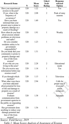
Page 138 www.ijiras.com | Email: contact@ijiras.com V. RESULTS
Research Items N Mean Score Likert Scale Rating Response selected Option Have you experienced
erosion in the past?
320 1.22 1 Yes
If yes, what is the frequency of
occurrence?
320 2.08 2 Peak of rainy seasons
Have you been informed that your present area is prone to
property damage as a result of flooding?
320 1.40 1 Yes
How often do you hear about erosion related problems on television
and radio?
320 1.91 1 Weekly
Do you consider residents safety to be
government responsibility?
320 1.23 1 Yes
Do you think that your community is prone to property damage and
loss of life from erosion?
320 1.31 1 Yes
If yes why are you living in this area?
320 2.28 2 Educational needs Do you receive any
information before nay erosion event?
320 1.14 1 Yes
If yes through which medium?
320 1.13 1 Television
What other ways have you been educated about potential for loss
of life and damage to property as a result of
erosion?
320 2.94 2 Calls for proper use of
river and water resources
Evaluate communication from government agencies to the public on impending
erosion?
320 1.38 1 Adequate
Has government done anything to reduce your
damage potential and loss of life from
erosion?
320 1.36 1 Yes
Source: Field Survey, 2019
Table 1: Mean Scores Analysis of Awareness of Erosion Impact on Auchi Community
Mean score response analysis indicate that the respondents said yes to having experienced erosion in the past with frequency of occurrence in the peak of rainy seasons and the present area they live in is prone to property damage as a result of erosion. The respondents agree that they hear about erosion related problems on television and radio weekly. They considered residents safety to be government responsibility. In addition, majority of the respondents think that their communities are prone to property damage and loss of life from erosion but still live in area because of employment and business purposes. Furthermore, the study confirms that receiving information before any erosion event through the television medium. Most of the respondents said they have been not educated about potential for loss of life and damage to property as a result of erosion via calls for proper use of river and water resources. Findings suggest that there is
adequate communication from government agencies to the public on impending erosion and many of the erosion affected respondents received relief items after flooding mostly clothing through government. Generally, government has done well to reduce your damage potential and loss of life from erosion by relocating the erosion victims. Use of high quality building materials can be used to reduce or control erosion damage structural measures alongside loss from erosion. It is a general opinion or believe of the respondents that proximity to the main river exposes them more to erosion damage in the study area and they have suffered loss from erosion especially their properties.
Majority of the respondents have not been frequently evacuate sand, silt and waste materials from blocked drainage without first aids box for erosion disaster emergency. However, they frequently educate their household on potential for loss of life and damage of property from erosion because of aware of any flood warning system but never keep disaster emergency phone numbers. Finally, most of the respondents in the study area have on alternative plan to relocation should erosion occur.
S/No Erosion
Impact Severe (3) Little (2) No impact (1)
N Total Mean S.I Ranking
1 Housing 207 99 74 380 893 2.4 78.3 3
2
Economic Activities (Agriculture)
208 109 63 380 905
2.4 79.4 1 3 Transportation 156 153 71 380 845 2.2 74.1 4 4 Health 156 129 95 380 821 2.2 72.0 5
5
Water and Sanitation
226 88 66 380 920
2.4 80.7 2
Source: Author’s Computation, 2016.
Table 2: Erosion Impact Using Severity Index Analysis
Severity Impact analysis of flood in the table 1 above shows that erosion occurrence has impacted severely on agricultural activities in the study area and also effect water and sanitation alongside housing ranking 1st, 2nd and 3rd respectively. However, little impact of flooding on transportation activities and health ranking 4thand 5th. Severity index analysis indicates that erosion impacts on economic activities of agriculture and water/sanitation by 84.3% and 80.7%. The impact on housing recorded 78.3%. Transportation and health have severity impact index of flood by 74.1% and 72.0% respectively. Generally, the impact of erosion in the area of study predominantly affected agricultural activities which may have contributed to the current food supply crisis in the south-south region.
VI. CONCLUSION
Erosion menace has been a recurrent decimal in south-south region of Nigeria particularly in Auchi. The findings of dimension of factors that mostly predicts impact of erosion are summarized as follow:
There is agreement that factors of perceive factors on impact of erosion in Auchi have significant effect in terms of awareness and impact measures.
The of awareness and control measures impacted positively and significantly on erosion while perception of vulnerability has negative effect on erosion.
Page 139 www.ijiras.com | Email: contact@ijiras.com health challenges, and groundwater pollution among
others.
The study suggests that quality water and poor sanitation currently facing the community is characterized by the rippled effect of erosion which may account for the percentage records of health crisis as a result of dumping sites for refuse and economic hardship due to lack of fertile land to cultivate causing food shortage in Auchi which has resulted to increase in food prices.
VII. RECOMMENDATIONS
As the study confirms that awareness of erosion and structural control measures are significant factor of impact of erosion in Auchi, there should be continual awareness of erosion impact among the residence of the community through community meetings and interaction as the rain set to effectively utilized the needful structural measures to control erosion impact in Auchi. There should be adequate and better perception of vulnerability of erosion among the genral public for proper priority attention to the menace of erosion. Effort should be made by the state government to access the ecological funds to address the further occurrence of erosion avert the ravaging effects on farmland and roads/houses in the study area (Auchi).
ACKNOWLEDGEMENT
The map sites and pictures are taken based on the ethical consideration with got approval through the erosion management committee of the locals. We sincerely acknowledged the opinion of the respondents for making this work possible.
REFERENCES
[1] Zhao, X.N.; Huang, J.; Wu, P.T.; Gao, X.D. (2014) The dynamic effects of pastures and crop on runoff and sediments reduction at loess slopes under simulated rainfall conditions. Catena 2014, 119, 1–7.
[2] Umoru, A. T., Oyathelemi, E.O. & Sule, T.U.N. (2013): Groundwater Research and Development Potential in
Auchi Polytechnic: Philipa Idogho Campus. International Journal of Civil and Environmental Research (CER) www.iiste.org Vol.3, No.8, 2013 ISSN 2224-5790 (Paper) ISSN 2225-0514
[3] Sule, T.U.N., Umoru, A. T., & Oyathelemi, E.O (2014): Lithological Examination and Resistivity Trend Pattern Investigation of Groundwater Research in Philipa Idogho Campus Auchi Polytechnic, Auchi. International Journal of Environment and Earth Science Vol.4, No.8, 2014 ISSN 2224-3216 (Paper) ISSN2225-0948
[4] Jiang, F.S.; Huang, Y.H.; Wang, M.K.; Lin, J.S.; Zhao, G.; Ge, H.L. (2014) Effects of Rainfall Intensity and Slope Gradient on Steep Colluvial Deposit Erosion in Southeast China. Soil Sci. Soc. Am. J. 2014, 78, 1741– 1752.
[5] Akpokodje, C.E. & Akaha, C.T. (2010). Gully erosion geo-hazards in the south eastern Nigeria and Management implications. Scientia Africana 10:101
[6] Afegbua, U.K., Uwazuruonye, J., & Jafaru, B. (2016). Investigating the causes and impacts of Gully Erosion in Auchi, Nigeria: Journal of Geography, Environment and Earth Science International. 4(4): 1-13, 2016; Article no. JGEESI.22582
[7] Shi, Z.H., Ai, L., Fang, N.F., Zhu, H.D. (2012) modelling the impacts of integrated small watershed management on soil erosion and sediment delivery: A case study in the Three Gorges Area, China. J. Hydrol. 2012, 438, 156– 167.
[8] Deng, L., Shangguan, Z.-P., Li, R. (2012) Effects of the grain-for-green program on soil erosion in China. Int. J. Sediment. Res. 2012, 27, 120–127.
[9] Ajaero, K.C., & Mozie, T.A. (2011). The Agulu-Nanka gully erosion menace in Nigeria: what does the future hold for population at risk? Department of Geography, University of Nigeria, Nsukka.
[10] Department for Environment Food and Rural Affairs (DEFRA, 2005). Controlling soil erosion incorporating former advisory leaflets on grazing livestock, wind, outdoor pigs and the uplands: Department for Environment Food and Rural Affairs September 2005 [11] Associated Programme on Flood Management (APFM,