Carlos V Licon is an Assistant Professor in the Department of Landscape Architecture and Environmental Planning at Utah State University, Logan, Utah, USA. Telephone: +1–435–797–3978 Email: [email protected]
Caroline Lavoie is an Associate Professor in the Department of Landscape Architecture and Environmental Planning at Utah State University, Logan, Utah, USA. Telephone: +1–435–797–0505 Email: [email protected]
KEY WORDS Design studio education Design thinking process Large-scale systems Mapping
Representation Global context
Landscape Architecture Studio
in a Large, Complex and Remote
Location: The Learning Experience
of StudioMx
carlos v licon and caroline lavoie
EDUCATION
Studio projects offer students opportunities to shape and test their design skills. These challenging projects require them to develop knowledge and skills to address increasingly complex situations, ultimately preparing them to be professionals with insightful, creative design strategies. In a studio project, fourth-year undergraduate students in landscape architecture at Utah State University had to structure and map their understanding of a large urban area in northern Mexico for possible planning and design interventions. The students worked on integrating urban systems at the metropolitan scale and illustrated their findings through mapped concepts in a studio called StudioMx. After reviewing a selection of studio methodologies and processes operating in a global context, this paper describes the structure of StudioMx. With the focus on large urban systems in an unfamiliar location, the studio project’s goal was to stress the need to frame analyses and design approaches in creative and abstract ways before investing efforts in a detailed design outcome. The learning objectives were to increase students’ awareness of the design thinking process and to explore creative ways of conveying design approaches.
Design education in a global context
In landscape architecture and environmental planning curricula, key terms such as globalisation, internationalisation, multiculturalism, cross-cultural education, student exchanges and service-learning programmes are becoming commonplace. Cross-disciplinary dimensions in various forms of teaching and research, often through service-learning projects, are now present in most of the landscape architecture programmes in the United States, Europe and Australia (Bull, 2004; Forsyth et al, 1999; Hou et al, 2005; Myers et al, 2005). In all of these projects, the common learning objectives focus on heightening students’ awareness of cultural differences in thoughts, values and worldviews for planning and design processes. Sensitivity to cultural differences associated with values different from those of the students is crucial. Myers et al (2005) suggest that this perspective has the potential to transform students, both personally and professionally. This transformation may in turn increase sensitivity to another culture’s reality and thus introduce a different framework of thinking that enriches the design process. However, given travelling internationally is not always possible, students in their future professional lives may work on projects in unfamiliar cultures and sites that they cannot visit. Yet they still need to find ways to understand those cultural perspectives and propose design solutions to issues in these unfamiliar contexts.
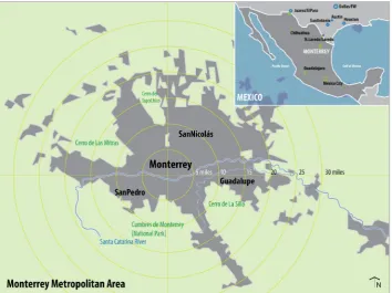
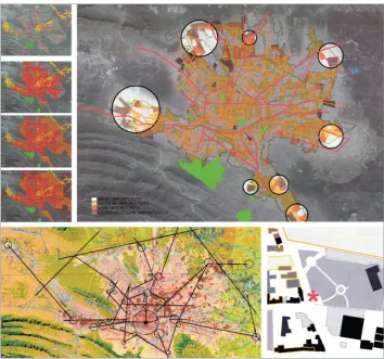
to explore creative ways of conveying design approaches. A group of 22 students in their last year of the undergraduate programme at Utah State University, USA enrolled in StudioMx. As their final studio, it offered one last opportunity to shake up and make them question their design-solving strategies. Here they could articulate a design focused on identifying, selecting and mapping metropolitan systems to build a conceptual description of the Monterrey metropolitan area in northern Mexico (figure 1). Maintaining the metropolitan scale and considering more than one system (that is, water, transportation or socioeconomic status) helped reinforce the need to represent complex phenomena through abstract graphic statements.
Most students had highly limited information about, as well as limited experience and personal knowledge of, the place. Because one of the instructors had had a short stay in the area and the other had lived there, they were able to provide some basic background information. To create a studio setting and a design exercise in which students could build their own questions and frame answers, the studio task:
• was on a large scale, which is an unfamiliar scale for undergraduate students in landscape architecture to work at;
• used a remote study area with limited information; and
• emphasised using interpretation and representation to create a framework rather than programme-defined solutions.
Expanding the boundaries of studio models: a brief overview
Like other learning studio environments, a design studio expands students’ knowledge, abilities, creative capacity and critical skills in different directions. Through multiple collaborative and creative efforts to get the most from the studio model, studio educators gain a wide array of views and contributions. For our studio, we found particularly valuable the work on several alternative studio structures, emphasising a cross-cultural perspective and creatively using mapping and drawing to represent system thinking and scenario creation.
An undergraduate landscape architecture design studio in Utah State University provides students with reliable and concise information about programme needs, site location and conditions, and a set of qualitative and performance-based goals. The students then build their understanding of the problem, develop some concepts and unfold the design implications of these ideas as they each develop a series of products aimed at clarifying different levels of descriptive knowledge and control of the proposed solution. As the requirements increase in complexity and in the number of factors to consider, students address multiple issues and develop a consistent design methodology for future problem solving. In the process, they also build theoretical positions and value-driven attitudes toward place, technology and the role of the designer in a larger socio-economic context.
at this introspective action. Broader goals in StudioMx were to establish the importance of articulating an approach as part of the design process and to create awareness of how it is critical to determining outcomes.
On studio structure
Armstrong and Robbins (1999) developed a studio course using abstract forms of representation and incorporating debate and discussion to induce a conceptual shift for their students in design thinking. They set up their studio process using a dialectical process of reflection – emphasising Schön’s (1983) Reflective Practitioner together with the use of ‘abstraction and metaphor to represent complex issues’ (Armstrong and Robins, 1999, p 59). Of particular importance in StudioMx was the creative abstraction of ideas, concepts and representation as a way of conveying new understanding of design thinking. Moreover, StudioMx addressed the students’ individual appropriation of the analysis process as value-laden, where students are, as Armstrong and Robbins (1999) suggest, ‘taking discrete aspects of the problem and transforming them through abstraction’ (p 62).
In a studio focused on service learning, Forsyth et al (1999) introduced their students to new territory that targeted a community group with a cultural background and value system different from their own. One of the strengths in that studio was the working relationship it established with the Latino youth. As a community service learning project, it focused on products for students and the community.
Both studios described above emphasise value-driven approaches as critical elements in a design process. StudioMx facilitates the discussion and representation of the values students have as designers through the selection and mapping decisions the teams make to describe the abstract and complex array of metropolitan systems.
On cultural differences
StudioMx was conducted on a larger scale than most of the cited projects, but it also aimed to increase awareness of cultural differences. Even through its remote location in Mexico, the USA-directed studio highlighted potential perception issues and cultural preconceptions for students. For example, they might perceive a spatial correlation between geographic features, including slope, flooding or earthquake vulnerabilities, and mapped issues of crime, poverty, income, traffic or employment concentration.
Hou et al (2005) explored cross-cultural dimensions through virtual and face-to-face interactions in the Global Classroom Project, where students learnt by ‘developing models of design collaboration and communication skills across cultural, physical, and technological barriers’ (p 127). StudioMx puts this concept to work by promoting team collaboration and critical thinking for discussions on creating concepts, interpreting knowledge and refining proposals.
StudioMx was not structured to offer an on-site cross-cultural experience. However, the project location created a transcultural dimension for student learning and linked to cross-cultural studios because exploring unfamiliar territory can stimulate self-awareness and reflection on ideas about design, space, culture and the role of a designer. This design exercise involved examining interpretations contained within specific cultural, technical and geo-spatial boundaries.
On mapping and representation
Representation involves a selective process to reveal layers of information and bring deeper understanding of the landscape expressed by drawings, maps, collages, paintings or other means of storytelling. Using different approaches and methods, design studios aim to broaden the dimensions of relationships and systems. With dioramas and collages, Clarke (2005) searches for alternative modes to represent dynamic relationships of multiple landscape processes. In the large-scale, post-mining landscapes of the American West, Berger (2002) explores representational systems to reveal and envision the future of reclaimed landscapes. As he puts it, such representation ‘allows one to find hidden relationships and processes rather simply “image” them’ (p 11). In addition, he emphasises the role of mapping as a dialogue between landscape, reader and mapper, as well as the role of subjectivity in such relationships. Similarly, mapping helped StudioMx students establish a dialogue with the site and to explore relationships among identified features and systems.
Drawing as a representation can be another practice for visual research that helps in discovering and experiencing the landscape (Kabir, 2012; Lavoie, 2005). For Lavoie (2005), drawing is a mode not only of representation but also of perception, interpretation and reflection. Similarly, for Kabir (2012) drawing is a means of seeing selectively, establishing a visual dialogue and building shared understandings by communicating and creating relationships through participatory drawing. In StudioMx, in addition to being an instrument for communication and dissemination, drawing was an important research and exploration tool.
On dynamic systems and flows
The notion of urban environments as a complex array of social, environmental and infrastructural systems (Kennedy et al, 2012) helped StudioMx establish a foundation for identifying and selecting elements to formulate a description of an urban area. The studio aimed to demonstrate that urban environments are multidimensional, multicultural and built by complex systems that require a multifaceted and creative process of synthesis (Clemmensen et al, 2010). Furthermore, Findeli (2001) proposes adopting a systems view of the design process, in which the role of the designer, and by extension the designed outcome, is an intervention aimed at changing the state of the system under consideration instead of moving from a problem to a solution. Lyster (2012) builds systems by looking at territory and public space based on time rather than distance. This approach highlights the dynamics of the urban environments over more static spatial perceptions. Our studio encouraged Lyster’s ideas on temporal systems and flows as a way of building spatial knowledge in landscape urbanism. The focus on natural and artificial flows can open new opportunities
and paradigms to conceptualise urban environments. This approach also requires new ways of representation, where ‘approaching the city through flow rather than form necessitates new ways to represent the city beyond conventional methods’ (Lyster, 2012, p 55).
StudioMx process
To map is to take the measure of the world. Taking measure involves, on the one hand, selection, translation, and differentiation, and on the other, visualizing, conceptualizing, recording and representing. Thus mapping is first and foremost a projection of order, of a particular order, of a particular logic and way of seeing. (Akkach, 2002, p 16)
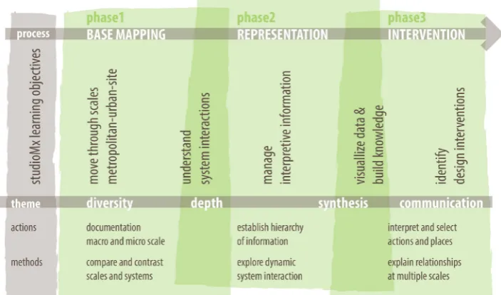
The studio project was implemented in three main phases (see process framework in figure 2): first, a base mapping phase of documentation and analysis; second, a phase of representing issues and suggesting strategies (again through creative mapping); and third, an intervention phase, where students were encouraged to be more prescriptive in their recommendations. The first task was to create and represent a remote recognition of the place. Because no site visits were possible, the students had access only to secondary data. They could refer to a geographic information systems (GIS) series of maps provided by the Centro de Desarrollo Urbano y Territorial del Tecnológico de Monterrey (Centre for Urban and Regional Development (CEDEM) at Monterrey Tech). In addition, through videoconferencing with the Centre, the students were able to discuss with local researchers some of the most important planning issues in the Monterrey metropolitan area. Flooding emerged as one of the critical areas of concern, having the greatest impact on the area’s safety and function.
The outcome of this studio project demonstrated that mapping and representation can help students understand interactions of metropolitan systems among and within different scales, building awareness of urban, metropolitan and regional systems. Using representation as a tool for analysis, students were encouraged to be creative in their analysis and communication. Releasing the students from geographic tacit agreements gives mapping the possibility of becoming what Harmon and Clemans (2009) describe as ‘shorthand for ready metaphors: seeking location and experiencing dislocation, bringing order to chaos, exploring ratios of scale, charting new terrains’ (p 10). The studio was structured in a way that would allow students to discover new thinking terrains, ideas and arguments that were not based exclusively on layers of information, but also developed through establishing relationships between systems. Lectures and readings for the studio focused on the following interrelated themes, aimed at stressing new roles of maps and representations typologies:
• mapping as a measure and a concept (Akkach, 2002; Lyster, 2012);
• mapping as media and knowledge (Cosgrove, 2008; Waldheim and Berger, 2008);
• mapping as an interrelated and aggregated structure (Harmon and Clemans, 2009; Kennedy et al, 2012); and
• mapping as reflection and abstract representation (Armstrong and Robbins, 1999; Walliss and Lee, 2001).
Phase 1: Base mapping
For this first phase of the StudioMx process, students presented a simplified version of their understanding of the metropolitan area of Monterrey. This analysis involved a high degree of interpretation of existing information. In this first face-off with the data, they had to identify, describe, assemble and combine at least two systems in the metropolitan area. Some of the themes the students chose combined two or more of the following features:
• water, including water supply and wastewater disposal;
• transportation, especially commuting patterns and the relationship between housing and employment centres;
• socio-economic status, the spatial distribution of wealth and the physical characteristics of illegal settlements;
• land values and proximity to downtown and other business centres; • density and land use as a guiding factor in recent urban growth; • growth and the incorporation of small surrounding towns; • landform and surface drainage;
• infrastructure and its vulnerability related to road capacity, potable water sources, health, and medical service providers; and
• natural disasters such as flooding, earthquakes and landslides.
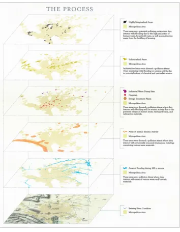
Figure 3: Example of student description of analytical process, showing a selection of spatial patterns for Monterrey, Mexico. Each layer represents a qualified statement of interrelated systems at the metropolitan scale.
Phase 2: Representation
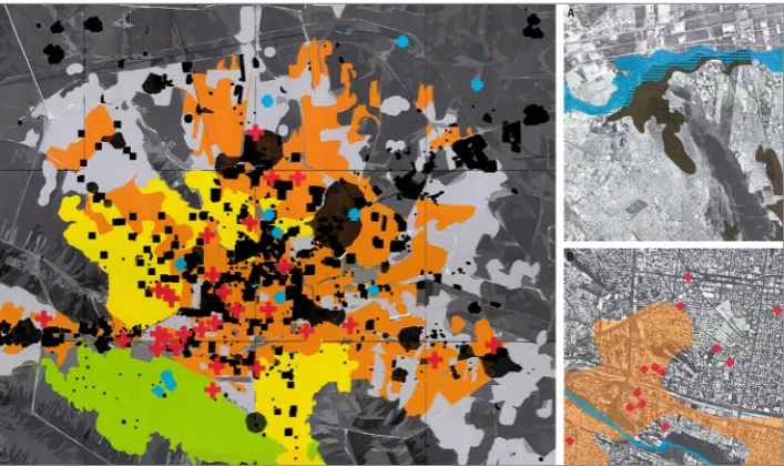
Representation helped students to discover mapped expressions of observed features, identify issues and find potential interconnection between systems (figure 5). In this second phase of StudioMx, they produced a graphic narrative of their acquired knowledge of the place. Because the students were unfamiliar with the area, they had to accept that the message they articulated through their maps was interpretative and somewhat subjective. In a series of iterations, students tested different formats and combinations of systems to convey a synthesised idea. To avoid frustration or confusion due to any lack of additional specific information, the focus was on the synthesis of the discovered issues, patterns and ideas.
Phase 3: Intervention
For the final phase of the StudioMx process, students mapped the various systems on which they chose to focus. They were asked to propose a framework for intervention that could be applied at a smaller scale, but would highlight relationships between different systems they had previously identified at metropolitan scale. This proposed intervention captured their understanding of the larger-scale issues expressed through a piece of the larger complex mosaic for the systems analysed (figure 6). It provided an avenue to give formal shape to emerging and abstract findings, observations and suggestions.
However modest or limited, this design and planning intervention effort was an effective learning experience that built the explanatory statement of purpose and enhanced the students’ understanding of the interpretive nature of the design process. In addition, students improved their collaboration and communication skills, as well as their technical abilities and critical thinking, through this intervention phase. As patterns became visually clear, the students’ understanding of the place evolved and their synthesis became a more direct message with stronger prescriptive power.
Findings
The learning sequence for StudioMx expected students to create an informed vision of the place by developing a way to navigate and understand systems (that is, connectivity systems) and their elements (nodes, hubs and so on). They had to rearrange and manage their ideas, and finally elaborate visual statements and suggestions to address the opportunities found through their analysis and interpretation. The large scale, the distance and the different cultural context of the case under study helped the students reflect on and be more critical of their design and planning approach rather than quickly move to produce a solution. During studio sessions, students realised they needed to summarise and represent their ideas and conclusions graphically, to avoid losing their grasp of the topic due to the potentially overwhelming scale, distant location and abstract complexity. Instructors were careful not to force students to rely on preconceived ideas; rather, in the tasks throughout the whole process they guided students to produce work that was more the result of a deliberate representation of the analysis and a creative mapping exercise.
Three themes emerged from the students’ work with increasing interpretive responses. The first stayed focused on the physical attributes of the place such as conflicts over urban land use. The second was a theme that gathered ideas around a single and more complex issue, such as traffic or flooding. The third theme included more abstract topics such as health, connectivity and poverty and explored ways of connecting them with concrete physical attributes.
The studio project created the need to build a concise yet powerful representation of the problem. StudioMx challenged the students’ tendency to rely too heavily on the accessible aerial photography online. Early on, students learnt that it was not easy to represent the scale and the problems by an aerial photo alone. In terms of analysis and deliverables, some teams quickly defined an issue, while others had to explore and test several approaches until one or more emerged as viable.
With time limitations inherent in StudioMx and with an original purpose of creating an opportunity for self-awareness of the design thinking process, students spent less time in the intervention phase and more time on thinking about how to represent their formulated understanding of the place to engage others in their discussion of findings. This hands-on, task-based approach, particularly in the initial mapping phase, was highly effective in promoting critical thinking and higher-level discussions.
Because they had to overcome the initial difficulties of changing scales and creating interpretive and abstract design statements, students articulated their design process more consciously and explicitly. They included mapped ideas with a variety of abstract concepts. The final, intervention phase was aimed at turning these collections of abstract concepts into communicable and more prescriptive strategies. Most of the projects in StudioMx stayed at an abstract level as the emphasis was on the design thinking process.
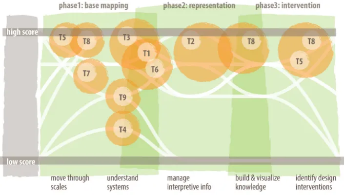
As represented in figure 7, to progress through the learning objectives the student teams had to, first, develop control over the scales of the project (the metropolitan, the urban and the site-specific scales) and then build their understanding of systems interaction. These two learning objectives defined the first third of the studio process and established the first level of mapping as an exploratory tool. Selectively managing the information and visualising these interpretations of data defined the two learning objectives for the representation phase of the studio process. How the students chose to transfer their knowledge and understanding of the place into more specific actions, and how they chose to communicate these recommendations were measured in the final phase of StudioMx.
Resilience as a framework
As expected, students had different ways of expressing a common theme when they were identifying issues and later when they were developing mapping representations. In particular, their proposals differed in their expression of the idea of resilience, as the approach for analysis and as the concept driving goals. Resilience captures planning interests in systems recovery and reorganisation after disturbing phenomena (Godschalk, 2003; Walker et al, 2004). Anecdotally, some students commented that, because they were really impressed by the damage caused by past flooding events in Monterrey, they made this the dominant focus of their analysis. Resilience also provided a good thematic anchor concept. Students discussed how to adopt and adapt to the new realities of violence and the efforts to recover and rebuild public spaces. They were able to see, through the studio, that resilience may be particularly evident in a place like Monterrey, where local pride and capacity drive efforts to reduce the fragility and vulnerability of places, communities and systems.
Conclusions
As landscape architecture students learn and develop designer skills, this type of international studio project offers not only delivery opportunities, but also critical and introspective opportunities to temper their approach to become confident designers with trust in the process. Studio courses are a unique learning tool that allow students to explore ideas collaboratively and creatively, without the expectation of a predefined response. As well as having to deal with uncertainty in a more explicit format, through StudioMx students experienced the core nature of design as a decision-making process loaded with interpretation, representation and subjective statements.
As a learning environment, this studio setting provoked our thinking on the nature of different studio settings. In any studio learning environment, we must ask, how do we provide our students with technical challenges and at the same time establish powerful avenues for formulating problems creatively? Through a creative and open studio process, design instructors can encourage students to take risks with and test ideas, while challenging preconceived ideas of place,
scale and culture. Students learn about their own interactions, attachments, approaches and expressions. It is through this type of design challenge that they will ultimately become empowered to build their own questions and frame their own answers with a bold imagination, heightened awareness and critically informed actions.
This paper contributes to the body of studies extending spatial and contextual boundaries of design education and is a potential case study for future studio teaching. Building a strategic process to conduct design efforts in urban environments with multidimensional, multicultural, complex and interrelated systems is not easy: students struggle to make progress and establish their own process clearly. In this sense the proposed studio structure may help to enhance a reflective process that we hope can continue throughout students’ professional lives.
Acknowledgements
Thanks to Pilar Noriega Crespo from the Centre for Urban and Regional Development at Monterrey Tech, and the students in StudioMx: Jeffrey Benson, Devin Christensen, Jason Cooper, Adam Dambrink, Morgan Handley, Adam Heaton, Dustin Hislop, Preston Hopkin, Adam Humpherys, Scott Jensen, Rachel Lingard, Kevin Linsley, Abel Lish, Trissta Lyman, Hayley Pratt, Corbin Rasmussen, David Runkel, Tyson Stoddard, Benjamin Swaner, Travis Tanner, Christopher Worthington and Tina Zaponsek.
REFERENCES
Akkach, S (ed) (2002) De-placing Difference: Architecture, Culture and Imaginative Geography,
Adelaide: Centre for Asian and Middle Eastern Architecture, University of Adelaide.
Armstrong, H and Robbins, D (1999) Design through Debate: A New Studio, Landscape Review
5(2), pp 59–78.
Berger, A (2002) Representation and Reclaiming: Cartographies, Mappings, and Images of Altered American Western Landscapes, Landscape Journal 21, pp 1–22.
Brown, CR and Morrish, WR (1988) Western Civic Art: Works in Progress, Places 5(4), pp 64–77. Bull, C (2004) Rhetoric and Reality: The Internationalisation of Education as Experienced in the Cross-cultural and Cross-disciplinary Studio, Landscape Review 9(2), pp 70–86.
CEDEM [Centro de Desarrollo Metropolitano y Territorial] (2006) Area Metropolitana de Monterrey, Mapa Base. Accessed 1 April 2011, http://cedem.mty.itesm.mx/imagenes/ mapabaseAMM.jpg.
Clarke, HAG (2005) Land-scopic Regimes: Exploring Perspectival Representation Beyond the ‘Pictorial’ Project, Landscape Journal 24, pp 50–68.
Clemmensen, TJ, Daugaard, M and Nielsen, T (2010) Qualifying Urban Landscapes, Journal of Landscape Architecture 5(2), pp 24–39.
Corner, J (1990) A Discourse on Theory I: ‘Sounding the Depths’ – Origins, Theory, and Representation, Landscape Journal 9(2), pp 61–78.
–––(1994) Taking Measures across the American Landscape, AA Files (27), pp 47–54. Cosgrove, DE (2008) Geography and Vision: Seeing, Imagining and Representing the World,
London: IB Tauris.
Davies, A and Reid, A (2000, December) Uncovering Problematics in Design Education: Learning and the Design Entity. Paper presented at the International Conference Re-inventing Design Education in the University, Curtin University of Technology, Perth, Western Australia.
Forsyth, A, Lu, H and McGirr, P (1999) College Students and Youth Collaborating in Design: Research on the Design Studio, Landscape Review 5(2), pp 26–42.
Godschalk, DR (2003) Urban Hazard Mitigation: Creating Resilient Cities, Natural Hazards Review 4(3), pp 136–43.
Harmon, KA and Clemans, G (2009) The Map as Art: Contemporary Artists Explore Cartography, New York: Princeton Architectural Press.
Hou, J, Kinoshita, I and Ono, S (2005) Design Collaboration in the Space of Cross-Cultural Flows, Landscape Journal 24(2), pp 125–39.
INEGI [Instituto Nacional de Estadística y Geografía] (2013) Espacio y Datos de México. Accessed 10 May 2013, www3.inegi.org.mx/sistemas/mapa/espacioydatos.
Jacobs, P (1991) De, In, Re {form}ing Landscape, Landscape Journal 10(1), pp 48–56.
Kabir, KH (2012) Why Is Drawing Important to Research?, Journal of Landscape Architecture 7(1), pp 34–45.
Kennedy, C, Baker, L, Dhakal, S and Ramaswami, A (2012) Sustainable Urban Systems: An Integrated Approach, Journal of Industrial Ecology 16(6), pp 775–779.
Lavoie, C (2005) Sketching the Landscape: Exploring a Sense of Place, Landscape Journal (24), pp 1–5.
Lyster, C (2012) Learning from FedEx: Lessons for the City, Journal of Landscape Architecture 7(1), pp 54–67.
Myers, DN, Hill, M and Harwood, SA (2005) Cross-cultural Learning and Study Abroad: Transforming Pedagogical Outcomes, Landscape Journal 24(2), pp 172–184.
Schön, DA (1983) The Reflective Practitioner: How Professionals Think in Action,New York: Basic Books.
Waldheim, C and Berger, A (2008) Logistics Landscape, Landscape Journal 27(2), pp 219–46. Walker, B, Holling, CS, Carpenter, SR and Kinzig, A (2004) Resilience, Adaptability and Transformability in Social–Ecological Systems, Ecology and Society 9(2), p a5.
Walliss, J and Lee, G (2001) Landscape and Representation: (Re)Mapping the Flinders Ranges,