https://doi.org/10.5194/se-10-2045-2019
© Author(s) 2019. This work is distributed under the Creative Commons Attribution 4.0 License.
Tectonic processes, variations in sediment flux, and eustatic
sea level recorded by the 20 Myr old Burdigalian transgression
in the Swiss Molasse basin
Philippos Garefalakis and Fritz Schlunegger
Institute of Geological Sciences, University of Bern, Bern, 3012, Switzerland Correspondence:Philippos Garefalakis ([email protected]) Received: 4 February 2019 – Discussion started: 1 March 2019
Revised: 26 September 2019 – Accepted: 3 October 2019 – Published: 19 November 2019
Abstract. The stratigraphic architecture of the Swiss Mo-lasse basin, situated on the northern side of the evolving Alps, reveals crucial information about the basin’s geometry, its evolution, and the processes leading to the deposition of the siliciclastic sediments. Nevertheless, the formation of the Upper Marine Molasse (OMM) and the controls on the re-lated Burdigalian transgression have still been a matter of sci-entific debate. During the time period from ca. 20 to 17 Ma, the Swiss Molasse basin was partly flooded by a shallow marine sea striking SW–NE. Previous studies have proposed that the transgression occurred in response to a rise in global sea level, a reduction of sediment flux, or an increase in tec-tonically controlled accommodation space. Here, we read-dress this problem and extract stratigraphic signals from the Burdigalian molasse deposits that can be related to changes in sediment supply rate, variations in the eustatic sea level, and subduction tectonics. To achieve this goal, we conducted sedimentological and stratigraphic analyses of several sites across the entire Swiss Molasse basin.
Field investigations show that the transgression and the subsequent evolution of the Burdigalian seaway was char-acterized by (i) a deepening and widening of the basin, (ii) phases of erosion and non-deposition during Lower Freshwater Molasse (USM), OMM, and Upper Freshwa-ter Molasse (OSM) times, and (iii) changes in along-strike drainage reversals. We use these changes in the stratigraphic record to disentangle tectonic and surface controls on the fa-cies evolution at various scales. As the most important mech-anism, rollback subduction of the European mantle litho-sphere most likely caused a further downwarping of the fore-land plate, which we use to explain the deepening and widen-ing of the Molasse basin, particularly at distal sites. In
ad-dition, subduction tectonics also caused the uplift of the Aar massif. This process was likely to have shifted the patterns of surface loads, thereby resulting in a buckling of the foreland plate and influencing the water depths in the basin. We use this mechanism to explain the establishment of distinct depo-sitional settings, particularly the formation of subtidal shoals wherein a bulge in relation to this buckling is expected. The rise of the Aar massif also resulted in a reorganization of the drainage network in the Alpine hinterland, with the con-sequence that the sediment flux to the basin decreased. We consider this reduction in sediment supply to have amplified the tectonically controlled deepening of the Molasse basin. Because the marine conditions were generally very shallow, subtle changes in eustatic sea level contributed to the forma-tion of several hiatuses that chronicle periods of erosion and non-sedimentation. These processes also amplified the tec-tonically induced increase in accommodation space during times of global sea level highstands. Whereas these mecha-nisms are capable of explaining the establishment of the Bur-digalian seaway and the formation of distinct sedimentolog-ical niches in the Swiss Molasse basin, the drainage reversal during OMM times possibly requires a change in tectonic processes at the slab scale, most likely including the entire Alpine range between the Eastern and Central Alps.
ex-plain the various hiatuses and amplified the deepening of the basin during eustatic highstand conditions.
1 Introduction
Foreland basins and their deposits have often been used to explore the tectonic evolution of their hinterlands, mainly because these basins are mechanically coupled with the ad-jacent mountain belts (Beaumont, 1981; Jordan, 1981; De-Celles, 2004). The formation of these foreland basins occurs through the flexural downwarping of the underlying litho-sphere in response to loading, which results in the formation of a wedge-shaped trough where sediment accumulates (De-Celles and Giles, 1996; Allen and Allen, 2005). The shape of the foreland trough depends on the mechanical properties of the foreland plate (Sinclair et al., 1991; Flemings and Jor-dan, 1990; Jordan and Flemings, 1991), the load of the sed-imentary fill itself (Flemings and Jordan, 1990; Jordan and Flemings, 1991), and predominantly the tectonic and geody-namic processes leading to changes in plate loading (Beau-mont, 1981; Jordan, 1981; Allen et al., 1991; Sinclair et al., 1991; DeCelles and Gilles, 1996). Additionally, a foreland basin can either be occupied by a peripheral sea when sed-iment flux is lower than the formation rate of accommoda-tion space or by a fluvial system if the opposite is the case (Sinclair and Allen, 1992). A shift from terrestrial to ma-rine conditions, for instance, can occur through a reduction in sediment flux, an increase in tectonically controlled sub-sidence rate (Sinclair et al., 1991), or a rise in the eustatic sea level (Reichenbacher et al., 2013). This has particularly been inferred for the North Alpine Foreland Basin, or the Molasse basin, situated on the northern side of the European Alps (Fig. 1a), which experienced a change from terrestrial to marine conditions during Burdigalian times ca. 20 Myr ago (e.g. Matter et al., 1980; Pfiffner, 1986; Schlunegger et al., 1997a; Kempf et al., 1999; Kuhlemann and Kempf, 2002; Ortner et al., 2011). In the Swiss part, this transgres-sion resulted in the establishment of a shallow marine sea-way, linking the Paratethys in the NE with the Tethys in the SW (Allen et al., 1985), and it is recorded by the deposition of the Upper Marine Molasse group (OMM; Matter et al., 1980; P. A. Allen, 1984). Although the history and geom-etry of the Burdigalian seaway and the related sedimentary processes are well known through detailed sedimentological and chronological investigations (e.g. Lemcke et al., 1953; P. A. Allen, 1984; Allen et al., 1985; Homewood et al., 1986; Doppler, 1989; Keller, 1989; Jin et al., 1995; Salvermoser, 1999; Strunck and Matter, 2002; Kuhlemann and Kempf, 2002; Reichenbacher et al., 2013), the controls on this trans-gression have still been a matter of ongoing scientific de-bate. Previous authors (e.g. Allen et al., 1985; Homewood et al., 1986; Keller, 1989; Strunck and Matter, 2002; Reichen-bacher et al., 2013) proposed a combination of a reduced
sed-iment flux and a rise in global sea level as possible mecha-nisms. However, thermo-chronometric data from the core of the Alps (Lepontine dome, Fig. 1; Boston et al., 2017) and structural work in the external Aar massif (Fig. 1; Herwegh et al., 2017) revealed that the Burdigalian was also the time of major tectonic events, including thrusting in the Aar mas-sif and tectonic exhumation of the Lepontine dome (Schmid et al., 1996), leading to changes in surface loads in the Alps. Accordingly, it was proposed that tectonic processes could also have controlled the transgression of the peripheral sea through downwarping of the foreland plate (Sinclair et al., 1991). It is possible that the Swiss part of the Molasse basin bears key information to differentiate between these underly-ing mechanisms (eustasy, sediment flux, tectonics) because it is situated to the north of the Aar massif and the Lepontine dome (Fig. 1).
The aim of this paper is to disentangle tectonic processes, a reduction of sediment flux, and changes in the eustatic sea level as controls on the transgression of the OMM in the Swiss Molasse. We analysed OMM outcrops and sec-tions along the entire Swiss Molasse basin at both proximal and distal positions relative to the Alpine front (Fig. 1a). To this extent, we measured palaeo-flow directions, and we ex-plored the OMM deposits for their sedimentary facies and related depositional settings. We also determined the thick-ness and grain size of sedimentary bedforms, and we ap-plied hydrological concepts to calculate palaeo-water depths based on the measured parameters. However, a chronologi-cal framework is absolutely required for correlating sections across a basin where facies relationships are strongly hete-rochronous, as is the case for the Swiss Molasse basin (Mat-ter et al., 1980). Therefore, we also reassessed the temporal framework of the analysed sections through a compilation of previously published magnetostratigraphic and biostrati-graphic data, and we correlated the individual sections across the basin.
2 Geological setting
2.1 The architecture and evolution of the Alps
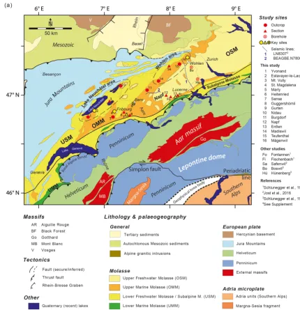
Be-Figure 1. (a)Simplified geological map of the European Alps based on a compilation by Kissling and Schlunegger (2018) and updated using additional information from Handy et al. (2015) and Pippèrr and Reichenbacher (2017); note the location of Fig. 2a and trace of(b).
(b)Simplified geological–geophysical section through the Central European Alps adapted from Kissling and Schlunegger (2018).
neath the core of the orogen, the ca. 160 km long (Lippitsch et al., 2003) lithospheric mantle slab of the European con-tinental plate bends and thus downwarps the foreland plate towards the SE (Fig. 1b). This bending was mainly driven by slab load due to the relatively large density of the subducted lithospheric mantle in comparison with the surrounding
thrust (Fig. 1b). On the southern side, the Alps are made up of the south alpine thrust sheets that consist of crystalline basement rocks and sedimentary units of African origin. This fold-and-thrust belt is bordered to the south by the Po basin (Fig. 1a). The northern side of the Alps are separated from the southern side by the north-dipping Periadriatic line that accommodated most of the shortening during the Oligocene and the early Miocene by backthrusting and right-lateral slip (Schmid et al., 1996).
Recently, slab load has been considered the major driv-ing force of the subduction history of the European plate and for the exhumation of crystalline rocks (Kissling and Schlunegger, 2018). This also concerns the exhumation of the Lepontine dome (Fig. 1), where normal faulting along the Simplon detachment fault resulted in rapid tectonic ex-humation of the dome between late Oligocene and early Miocene times with a peak recorded by thermo-chronometric data at 20 Ma (Fig. 1b; Hurford, 1986; Mancktelow, 1985; Mancktelow and Grasemann, 1997; Schlunegger and Wil-lett, 1999; Boston et al., 2017). This was also the time when the Aar massif, situated on the European continental plate (Fig. 1b), experienced a period of rapid vertical extrusion (Herwegh et al., 2017). Herwegh et al. (2017) and Kissling and Schlunegger (2018) proposed a mechanism referred to as rollback subduction to explain these observations. Accord-ing to these authors, delamination of crustal material from the European mantle lithosphere along the Moho resulted in a stacking of buoyant lower crustal rocks beneath the Lep-ontine dome and the Aar massif, forming the crustal root (Fry et al., 2010; Fig. 1b). These processes are considered to have maintained isostatic equilibrium between the sub-ducted lithospheric mantle and the crust and thus the ele-vated topography (Schlunegger and Kissling, 2015). Addi-tionally, they most likely balanced, through the stacking of the crustal root (Fry et al., 2010, Fig. 1b), the rapid removal of upper crustal material in the Lepontine dome at ca. 20 Ma (Schlunegger and Willet, 1999; Boston et al., 2017). Delami-nation of crustal material has also been invoked to explain the contemporaneous rapid exhumation and northward thrusting of the Aar massif along steeply dipping thrusts (Herwegh et al., 2017). These processes were contemporaneous with (i) the reorganization of the drainage network of the Central Alps (Kuhlemann et al., 2001a; Schlunegger et al., 1998), (ii) the decrease in sediment flux to the basin, as revealed by sediment budgets (Kuhlemann, 2000; Kuhlemann et al., 2001a, b), and (iii) the Burdigalian transgression in the Swiss part of the Molasse basin. We will thus refer to these pro-cesses when discussing the controls on the Burdigalian trans-gression within a geodynamic framework.
2.2 The architecture and evolution of the Molasse basin The Molasse basin is approximately 700 km long and strik-ing ENE–WSW from France to Austria, where it broadens from <30 km to a maximum width of ca. 150 km (Pfiffner,
1986; Fig. 1a). It is limited to the north by the Jura Moun-tains, the Black Forest, and Bohemian massifs, as well as to the south by the basal Alpine thrust (Homewood et al., 1986). Reconstructions of the evolution of the Molasse basin (Fig. 2a) have been the focus of many research articles over the past years (e.g. Matter et al., 1980; Homewood and Allen, 1981; P. A. Allen, 1984; Keller, 1989; Schlunegger et al., 1996; Sinclair, 1997; Kempf et al., 1999; Kuhlemann and Kempf, 2002; Ortner et al., 2011; Reichenbacher et al., 2013). This has resulted in the general notion that the large-scale subsidence history of the Molasse basin was closely linked with the geodynamic evolution of the Alps (Sinclair et al., 1991; Kuhlemann and Kempf, 2002; Pfiffner et al., 2002; Ortner et al., 2011; Schlunegger and Kissling, 2015). The de-velopment of this basin as a foreland trough has been consid-ered to commence with the closure of the Alpine Tethys in late Cretaceous times (Lihou and Allen, 1996; Schmid et al., 1996). This was the time when subduction of the European oceanic lithosphere with a large density beneath the Adriatic continental plate started. Large slab load forces resulted in a downwarping of the European foreland plate and the for-mation of a deep marine trough (Schmid et al., 1996), where sedimentation occurred by turbidites (Sinclair, 1997) on sub-marine fans (Allen et al., 1991; Sinclair, 1997; Lu et al., 2018; Reichenwallner, 2019). This first period of basin evo-lution has been referred to as the flysch stage in the literature (Fig. 2b; Sinclair and Allen, 1992). The situation changed at 35–32 Ma when the buoyant continental lithosphere of the European plate started to enter the subduction channel. Strong tension forces started to operate at the stretched mar-gin of the European continental crust, particularly beneath the Central Alps (Schmid et al., 1996), with the result that the subducted oceanic lithosphere of the European plate broke off (Davies and von Blanckenburg, 1995). The consequence was a rebound of the European plate, a rise of the Central Swiss Alps, and an increase in sediment flux to the Swiss Molasse basin (Sinclair, 1997; Kuhlemann et al., 2001a, b; Willett, 2010; Garefalakis and Schlunegger, 2018), which be-came overfilled at ca. 30 Ma (Sinclair and Allen, 1992; Sin-clair, 1997). The subsequent post-30 Ma stage of basin evo-lution has been referred to as the Molasse stage (Sinclair and Allen, 1992).
Figure 2.
resulted in erosion and recycling of the previously deposited Molasse units (Mazurek et al., 2006; Cederbom et al., 2004, 2011). This erosion reached deeper stratigraphic levels in the western part of the Molasse basin than in the eastern segment (Baran et al., 2014) with the consequence that the OMM de-posits are only fragmentarily preserved in the west (Fig. 2a). Sediment dispersal changed during the Molasse stage of basin evolution. Prior to 20 Ma, during USM times, measure-ments of sediment transport directions (Kempf, 1998; Kempf et al., 1999) and sediment provenance analysis (Füchtbauer, 1964) revealed that the sedimentary material was transported to the east by braided to meandering streams. At that time, a coastline was situated near Munich, separating a deep marine
Figure 2. (a)Detailed geological map of the area between Geneva and Zurich adapted from Kissling and Schlunegger (2018) showing the locations of data points referred to in this paper. The OMM de-posits at sites 1 to 16 have been mapped at the scale of 1 : 25 000, which was used to reproduce Fig. 6. In addition, the observations of the sections, outcrops, and drill core at sites 2, 4, 7, 9, 12, 13, and 16 are explicitly described in Sects. 4 and 5 of this paper. Please refer to Fig. 1 for the complete legend.(b)Lithostratigraphic scheme of the Molasse deposits in Switzerland. Modified after Keller (1989).
palaeo-flow information, particularly for the OMM. The es-tablishment of such a database, particularly the assignment of a more precise age to the drainage reversal, will be part of the scope of this article.
2.3 The Upper Marine Molasse
2.3.1 Lithostratigraphic and sedimentological framework
The Upper Marine Molasse (OMM) deposits, which are the focus of this study, mainly consist of a suite of shallow ma-rine sandstones and mudstones that were deposited between ca. 20 and 17 Ma (Fig. 2b) in a ca. 70–80 km wide sea-way (Allen and Homewood, 1984; Allen et al., 1985; Keller,
1989; Strunck and Matter, 2002). Close to the Alpine thrust front, the OMM successions are up to 900 m thick and thin to a few tens of metres towards the distal basin margin farther northwest.
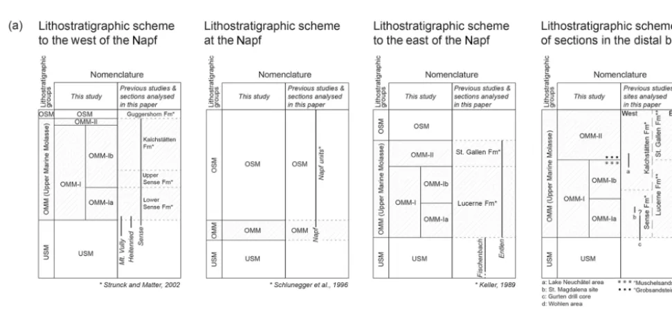
Large streams with sources in the Central Alps sup-plied their material to the Molasse basin, thereby forming megafans and conglomerate deposits with diameters>10 km that interfingered with the sea (Schlunegger et al., 1996; Kempf et al., 1999). Consequently, the facies relationships were strongly heterochronous across the basin, and terres-trial deposits, preserved as conglomerates of the OSM ac-cording to Matter (1964), grade into marine sediments of the OMM (Keller, 1989) over a lateral distance of a few tens of kilometres. This is also the case in the study area, where thick conglomerate packages situated at the Alpine thrust front ca. 50 km to the NE of the Aar massif (Napf conglomerates; Matter, 1964; Haldemann et al., 1980) sep-arate the basin into southeastern and northwestern segments with different lithostratigraphic schemes (Fig. 3a). For sim-plicity purposes, these areas will be referred to as the east-ern and westeast-ern segments in relation to the Napf. East of the Napf conglomerates, in the following text denoted as the Napf units (Matter, 1964), the OMM has been grouped in two transgressive–regressive packages referred to as the Lucerne and the St. Gallen formations (Keller, 1989). Both units com-prise a suite of sandstones with mudstone interbeds. They are separated from each other by a metre-thick palaeosol (Schlunegger et al., 2016). We will refer to these units as the OMM-I (Lucerne Fm) and the OMM-II (St. Gallen Fm), respectively (Fig. 3a). Keller (1989) additionally catego-rized the OMM-I east of the Napf units into a lower wave-dominated unit and an upper unit where tidal processes are recorded, which we refer to as the OMM-Ia and OMM-Ib, respectively.
West of the Napf, the OMM at the proximal basin bor-der has also been categorized in two units (Fig. 3a) but with a different scheme and different names. These are the Sense Formation at the base (suite of sandstones with mudstone interbeds) and the Kalchstätten Formation at the top (alternation of sandstones and mudstones). Further up-section, these marine deposits (Strunck and Matter, 2002) grade into the fluvial conglomerates of the Guggershorn For-mation and thus into the OSM (Strunck and Matter, 2002) (Fig. 3a). Magnetostratigraphic dating showed that the accu-mulation of the Guggershorn Formation occurred contempo-raneously with marine (OMM) sedimentation at more distal sites. These conglomerates thus represent the deposits of a braided stream that shed its material to the OMM sea, simi-lar to the Napf conglomerates.
Figure 3.
and Allen, 1981) where material with sources in the Central Alps was redistributed in the basin by strong tidal currents that entered the basin from the Tethys in the south and the Paratethys in the northeast (Allen et al., 1985; Kuhlemann and Kempf, 2002; Bieg et al., 2008). Lithostratigraphic relations suggest that the deposits at Fribourg most likely cor-respond to the lower Sense Fm (Python, 1996) and thus to the OMM-Ia (see the Discussion section and Fig. 3a).
In the basin axis, between the Lake Neuchâtel and Wohlen areas (Fig. 2a), coarse-grained sandstones with large-scale cross-beds in which individual grains are larger than 2 mm have been interpreted as subtidal sand waves (Allen and Homewood, 1984; Allen et al., 1985). These deposits are cal-careous sandstones with shelly fragments, referred to as the “Muschelsandstein” (Allen and Homewood, 1984; Allen et al., 1985, Fig. 3a). Alternatively, they occur as coarse-grained cross-bedded sandstones with large lithoclasts, also called the “Grobsandstein” (Jost et al., 2016).
2.3.2 Chronostratigraphic framework
Ages for the OMM deposits have been established by mul-tiple authors through palaeontological analyses of mam-malian fragments and teeth (Keller, 1989; Schlunegger et al., 1996; Kempf et al., 1999) as well as87Sr/86Sr chemo-stratigraphy (Keller, 1989). The latter yield a numerical age between ca. 18.5 and 17 Ma, particularly for the OMM-II on the eastern side of the Napf. Subsequent magneto-polarity chronologies (Schlunegger et al., 1996; Strunck and Mat-ter, 2002) paired with further micro-mammalian discoveries (Kempf et al., 1997; Kempf, 1998; Kälin and Kempf, 2009; Jost et al., 2016) allowed for an update of the chronolog-ical framework (Fig. 3b) of Keller (1989) through correla-tions with the magneto-polarity timescale (MPTS) of Cande
and Kent (1992, 1995) and the most recent astronomically tuned Neogene timescale (ATNTS; Lourens et al., 2004). This yielded the notion that the transgression of the periph-eral sea and the deposition of the OMM started at ca. 20 Ma and was synchronous, within uncertainties, across the entire Swiss Molasse basin (Strunck and Matter, 2002). However, a temporal correlation of sections across the Napf, i.e. be-tween eastern and western Switzerland (Fig. 3a), and a har-monization of the stratigraphic schemes (Fig. 3b) have not been achieved yet. This will be accomplished in this paper, and it will build the temporal framework for the discussion of the development of the basin.
3 Methods
3.1 Location of sections and available database
the sediments at these locations have been sketched in the field and on digital photos, thereby paying special attention to collecting information about the orientation and thickness of cross-beds. The sedimentary material of the ca. 200 m deep Gurten drill core is not available. However, the sediments were photographed at high resolution at the University of Bern in 1989 (see Fig. S3 in the Supplement). We used these photos to extract information on the lithofacies association encountered in the drilling.
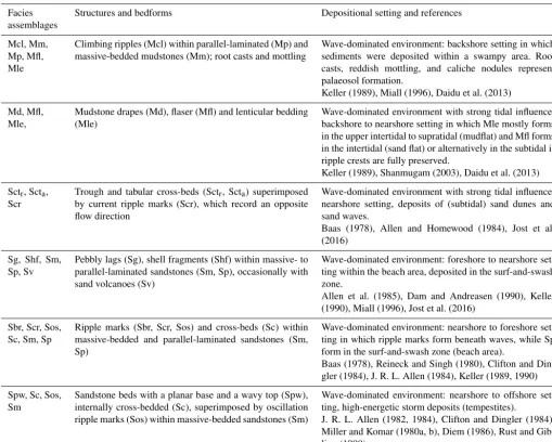
3.2 Reconstruction of sedimentary architecture The lithofacies have been identified (e.g. Schaad et al., 1992; Keller, 1989) based on the assemblage of sedimentary char-acteristics, including grain size, thickness, lateral extent if applicable, sedimentary structures, basal contact, colour, and fossil content (Tables 1 to 5). The lithofacies types corre-spond to individual bedforms (see Tables 1 to 5 for refer-ences), which bear information on flow strengths, flow direc-tions, sediment supply, and water depths (e.g. Keller, 1989). The combination of these parameters, usually recorded by distinct assemblages of lithofacies types, can be used to iden-tify distinct sedimentary settings. Related concepts of fa-cies analysis have been documented for fluvial deposits (Mi-all, 1978, 1985, 1996; Platt and Keller, 1992) but are less standardized for shallow marine deposits. Here, we followed Keller (1989) and Schaad et al. (1992), who developed a con-cept for shallow marine deposits whereby lithofacies types are grouped into facies assemblages in a hierarchic order, based on which distinct shallow marine settings can be in-terpreted. We followed these authors and assembled the vari-ous lithofacies types into five depositional settings, which are from land to sea: terrestrial, backshore, foreshore, nearshore, and offshore. We then mapped the depositional settings at the scale of 1 : 25 000 at various sites across the Swiss Molasse basin where suitable outcrops were present (see Fig. 2a for visited sites).
3.3 Determination of sediment transport directions Sediment transport directions were determined from orienta-tions of clast imbricaorienta-tions, gutter casts, and dip direcorienta-tions of cross-beds. In addition, the orientation of the coastline can be inferred from sediment transport within the surf-and-swash zone at the wet beach where rolling grains carve millimetre-thin rills in the beach deposits, which are oriented perpendicular to the coast. These rills are recorded by linear grooves, or parting lineations, on the surface of sandstones (J. R. L. Allen, 1982; Hammer, 1984). We thus measured the orientation of these features where visible. We also deter-mined the strike direction of oscillation ripple marks to infer the orientation of waves and thus of the coastline.
3.4 Calculation of palaeo-water depths
We analysed the sediments in the key sections according to their palaeo-water depths. For oscillation ripple marks, the ripple metrics (spacing between ripple crests and rip-ple heights) together with the grain size can be used to infer water depths at the time the oscillation ripples were formed (Diem, 1985; Allen et al., 1985; see the Supplement). We thus measured the ripple metrics with a metre stick together with grain sizes in the field and calculated the water depths following Allen (1997). Likewise, minimum water depths can be inferred from the heights of cross-beds as examples from modern streams have shown (Bridge and Tye, 2000; Leclair and Bridge, 2001). Please refer to the Supplement for the deviation of the related equations. Published informa-tion from deep drillings (Boswil 1; Hünenberg 1; Schluneg-ger et al., 1997a) and seismostratigraphic data (line 8307, Schlunegger et al., 1997a; line BEAGBE.N780025; Fig. S2 in the Supplement) completed the available database.
4 Results
4.1 Proximal basin border to the east of the Napf: Entlen section (site 13 in Fig. 2a)
The sedimentary suite of the ca. 370 metre thick OMM-Ia at Entlen (Figs. 4a and S4a in the Supplement) records a large diversity of lithofacies types (Table 1). Parallel-laminated (Sp), fine- to medium-grained sandstone packages are cen-timetres to decimetres thick and normally graded. These de-posits alternate with decimetre-thick low-angle cross-bedded units with tangential lower boundaries (Sc, Scta) and
ers with a massive structure (Sm). Gravel and pebble lay-ers (Sg) and shell fragments (Shf) are visible where sand-stone units have erosive bases. Current (Scr) and oscillation ripple marks (Sos), locally with branching crests (Sbr), as well as flame fabrics or sand volcanoes (Sv) are present only in some places. Fine-grained lithofacies include millimetre-to centimetre-thick parallel-laminated millimetre-to massive mudsmillimetre-tone layers (Mp, Mm). Siltstone climbing ripples (Mcl) are sub-ordinate in the OMM-Ia suite. Mudstone drapes (Md), a few millimetres thick, mostly occur on top of current ripple marks (Scr). In places, root casts are associated with yellow to ochre mottled colours.
The overlying ca. 430 m thick OMM-Ib (Figs. 4a and S4a in the Supplement) comprises fine- to medium-grained sand-stone packages with mudsand-stone interbeds (Table 1). Low-angle trough (Sctr) or tabular (Scta) cross-bedded sandstone
beds are several decimetres thick. The Sctrsandstones
con-tain current ripple marks (Scr) at their base, whereas lami-nae sets of Sctasandstones are interbedded with current
Table 1.Lithofacies encountered in the Entlen section. Facies
assemblages
Structures and bedforms Depositional setting and references
Mcl, Mm, Mp, Mfl, Mle
Climbing ripples (Mcl) within parallel-laminated (Mp) and massive-bedded mudstones (Mm); root casts and mottling
Wave-dominated environment: backshore setting in which sediments were deposited within a swampy area. Root casts, reddish mottling, and caliche nodules represent palaeosol formation.
Keller (1989), Miall (1996), Daidu et al. (2013) Md, Mfl,
Mle,
Mudstone drapes (Md), flaser (Mfl) and lenticular bedding (Mle)
Wave-dominated environment with strong tidal influence: backshore to nearshore setting in which Mle mostly forms in the upper intertidal to supratidal (mudflat) and Mfl forms in the intertidal (sand flat) or alternatively in the subtidal if ripple crests are fully preserved.
Keller (1989), Shanmugam (2003), Daidu et al. (2013) Sctr, Scta,
Scr
Trough and tabular cross-beds (Sctr, Scta) superimposed
by current ripple marks (Scr), which record an opposite flow direction
Wave-dominated environment with strong tidal influence: nearshore setting, deposits of (subtidal) sand dunes and sand waves.
Baas (1978), Allen and Homewood (1984), Jost et al. (2016)
Sg, Shf, Sm, Sp, Sv
Pebbly lags (Sg), shell fragments (Shf) within massive- to parallel-laminated sandstones (Sm, Sp), occasionally with sand volcanoes (Sv)
Wave-dominated environment: foreshore to nearshore set-ting within the beach area, deposited in the surf-and-swash zone.
Allen et al. (1985), Dam and Andreasen (1990), Keller (1990), Miall (1996), Jost et al. (2016)
Sbr, Scr, Sos, Sc, Sm, Sp
Ripple marks (Sbr, Scr, Sos) and cross-beds (Sc) within massive-bedded and parallel-laminated sandstones (Sm, Sp)
Wave-dominated environment: nearshore to foreshore set-ting in which ripple marks form beneath waves, while Sp form in the surf-and-swash zone (beach area).
Baas (1978), Reineck and Singh (1980), Clifton and Din-gler (1984), J. R. L. Allen (1984), Keller (1989, 1990) Spw, Sc, Sos,
Sm
Sandstone beds with a planar base and a wavy top (Spw), internally cross-bedded (Sc), superimposed by oscillation ripple marks (Sos) within massive-bedded sandstones (Sm)
Wave-dominated environment: nearshore to offshore set-ting, high-energetic storm deposits (tempestites).
J. R. L. Allen (1982, 1984), Clifton and Dingler (1984), Miller and Komar (1980a, b), Diem (1986), Rust and Gib-ling (1990)
Table 2.Lithofacies encountered in the Napf units.
Facies assemblages
Structures and bedforms Depositional setting and references
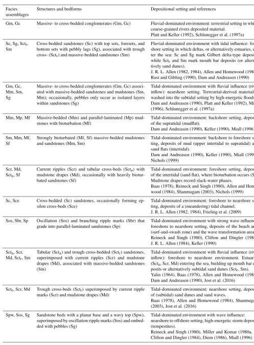
Gc, Gm Cross- (Gc) and massive-bedded (Gm) conglomerates Fluvial-dominated environment: megafan deposits within a braided river system. Gm and Gc form in active channels. Platt and Keller (1992), Schlunegger et al. (1997a) Sc, Sm, Mp Cross- (Sc) and massive-bedded (Sm) sandstones with
parallel-laminated mudstones (Mp)
Fluvial-dominated environment: megafan deposits within a braided river system. Sc and Sm from crevasse splay deposits. Mp facies (often yellowish–reddish mottled with caliche nodules and root casts) is evident for palaeosol gen-esis on a floodplain.
metres (Spw; Fig. 4a). Parallel-laminated (Sp) and massive-bedded (Sm) sandstone beds are decimetres thick and mainly found at the top of the OMM-Ib unit. Mudstones mostly oc-cur as mudstone drapes (Md) on top of oc-current ripple marks (Scr). Lenticular and flaser interbeds (Mle, Mfl) are decime-tres thick and characterized by current ripple marks with truncated crests. The OMM-Ib then ends with a metre-thick mudstone displaying yellow to reddish mottling, root casts, and caliche nodules.
Estimates of palaeo-water depths (see the Supplement) re-veal that the OMM-Ia sedimentary rocks were deposited in shallow conditions<5 m deep (Fig. 4a and Table S2). At the base of the OMM-Ib palaeo-water depths were>15 m and thus deeper compared to the OMM-Ia unit (see the Supple-ment). The OMM-Ib then shallows towards the top.
Measurements of the bedform orientations of the OMM-Ia deposits reveal sediment transport directions between 315◦NW and 60◦NE, with a dominant NE-directed
trans-port (Fig. 4a). During OMM-Ib times, transtrans-port directions were bidirectional, and measurements reveal the full range between 260◦W and 70◦E (Fig. 4a). Dominant transport di-rections of the OMM-Ib sediments change towards the N and to the W up-section.
4.2 Proximal basin border in the centre: Napf units (site 12 in Fig. 2a)
The Napf units, which are a terrestrial interval of the OMM and the OSM (Fig. 3; Schlunegger et al., 1996), are ca. 1550 m thick and include a succession of conglomer-ates, sandstones, and mudstone interbeds (Matter, 1964), which we categorize into five lithofacies types (Table 2, Fig. S4d in the Supplement). Individual conglomerate beds are up to 10 m thick and display stacks of 2–3 m thick beds with massive- (Gm) to cross-bedded (Gc) geometries. The sandstone beds occur as massive-bedded (Sm) and cross-bedded (Sc) units. Intercross-bedded mudstones are horizontally bedded (Mp) and have a yellowish–reddish mottling, caliche nodules, and root casts. Palaeo-flow measurements imply a change from a NE-directed transport during USM times to a NW-directed sediment transport between OMM-I and OSM times.
4.3 Proximal basin border to the west of the Napf: Sense section (site 7 in Fig. 2a)
The OMM at Sense (Figs. 4b and S4b) starts with a ca. 200 m thick succession of predominantly sandstones with some mudstone interbeds. Medium- to coarse-grained sandstone beds, up to 2–3 m thick, are massive-bedded (Sm), parallel-laminated (Sp), and trough cross-bedded (Sctr) (Table 3).
They also occur as metre-scale tabular cross-beds (Scta)
forming several metre-thick sigmoidal foresets (Sc) with top and bottom sets and pebbly lags (Sg). These packages are well exposed along a nearby road-cut (Heitenried, Fig. 2a;
46◦4902700N/7◦1804200E; Fig. S4c in the Supplement). Some of these Sctr cross-beds contain current ripple marks (Scr),
which are draped with a muddy layer (Md). Ripple marks also build up tabular sandstone bodies. They are either asym-metric (Scr) or symasym-metric (Sos) and may display branching crests (Sbr). In places, the sandstone bodies are highly biotur-bated (Sf). Mudstone interbeds are 10–20 cm thick, massive-(Mm) to parallel-laminated (Mp), and strongly bioturbated (Mf).
The first occurrence of 5–10 m thick sandstone beds at the 200 m stratigraphic level (Fig. 4b) marks a distinct shift in the stratigraphic record where several metre-thick cross-bedded sandstone beds dominate the sedimentary succession. At this level, (i) 5–10 m thick normally graded sandstone beds overlie an erosive base and display epsilon cross-beds (Sce); (ii) cross-bedded sandstones (Scta) are several metres
thick and tens of metres wide, and individual laminae sets are superimposed by current ripples (Scr) with an opposite flow direction than the cross-beds themselves; nearly all lam-inae sets of cross-beds (Sc) are superimposed by mudstone drapes (Md); and (iii) medium-grained sandstones display ridge-and-swale bedform geometries (Spw) with a small am-plitude of a few decimetres and a large wavelength of sev-eral metres. Some of these Spw facies are occasionally cov-ered with oscillation ripple marks (Sos). The Sense section ends with an alternation of decimetre-thick mudstone beds (Mm) and metre-thick massive- to cross-bedded conglom-erates (Gm, Gc). These conglomconglom-erates then evolve towards an amalgamation of several metre-thick, massive-, and cross-bedded packages characterizing the uppermost ca. 50 m suite of the Sense section (Fig. 4b).
Estimates of palaeo-water depths range between 5 and 10 m (Fig. 4b and Table S4 in the Supplement) during the deposition of the lowermost 200 m. Conditions were deep-est at the 200 m stratigraphic level, reaching water depths in the range of up to 30 m (see the Supplement). Measure-ments of sediment transport directions cover the range be-tween ca. 0◦N and 90◦E (Fig. 4b) at the base of the Sense section, which then changed to an axial, bipolar SW–NE-directed transport and to a W-SW–NE-directed transport towards the end of the section (Fig. 4b).
4.4 Central basin: St. Magdalena site and Gurten drill core (sites 4 and 9 in Fig. 2a)
The sandstones within a cave system near Fribourg (St. Mag-dalena; Figs. 2a and S4c in the Supplement) are medium- to coarse-grained and display an amalgamation of up to 1–3 m wide cross-bedded troughs (Sctr) with current ripple marks
Table 3.Lithofacies encountered in the Sense section. Facies
assemblages
Structures and bedforms Depositional setting and references
Gm, Gc Massive- to cross-bedded conglomerates (Gm, Gc) Fluvial-dominated environment: terrestrial setting in which coarse-grained rivers deposited material.
Platt and Keller (1992), Schlunegger et al. (1997a) Sc, Sg, Sctr,
Sm
Cross-bedded sandstones (Sc) with top sets, foresets, and bottom sets with pebbly lags (Sg), associated with trough cross- (Sctr) and massive-bedded sandstones (Sm)
Fluvial-dominated environment with tidal influence: fore-shore setting in which deltas, or alternatively estuaries, en-ter the sea: Sc and Sg mark Gilbert delta-type deposits, while Sctr and Sm mark mouth bar deposits (or
alterna-tively sand dunes).
J. R. L. Allen (1982, 1984), Allen and Homewood (1984), Rust and Gibling (1990), Dam and Andreasen (1990) Gm, Gc,
Mm, Sm, Sg
Massive- to cross-bedded conglomerates (Gm, Gc) associ-ated with massive-bedded sandstones and mudstones (Sm, Mm); occasionally, pebbles only occur as isolated layers within sandstones (Sg)
Tidal-dominated environment with fluvial influence (river inflow): nearshore setting. Terrestrial-derived material is washed into the subtidal setting by high-energetic floods. Dam and Andreasen (1990), Platt and Keller (1992), Miall (1996), Schlunegger et al. (1997a)
Mm, Mp, Mf Massive-bedded (Mm) and parallel-laminated (Mp) mud-stones with bioturbation (Mf)
Tidal-dominated environment: backshore setting, deposits of the supratidal (mudflat).
Dam and Andreasen (1990), Keller (1990), Miall (1996) Sm, Mm, Mf,
Sf
Strongly bioturbated (Mf, Sf) massive-bedded mudstones and sandstones (Mm, Sm)
Tidal-dominated environment: backshore to foreshore set-ting, deposits of mud (upper intertidal to supratidal) and sand flats (intertidal).
Dam and Andreasen (1990), Keller (1990), Miall (1996), Nichols (1999)
Scr, Md, Scta, Sf
Current ripples (Scr) and tabular cross-beds (Scta) with
mudstone drapes (Md), occasionally with heavily biotur-bated sandstones (Sf)
Tidal-dominated environment: foreshore setting, deposits of the intertidal (sand flat), where bioturbation occurs (Sf). Mudstone drapes record slack-water phases.
Baas (1978), Reineck and Singh (1980), Allen and Home-wood (1984), Shanmugam (2003), Nichols (1999) Sc, Sce Cross-bedded (Sc) sandstones, occasionally forming
ep-silon cross-beds (Sce)
Tidal-dominated environment: foreshore to nearshore set-ting, deposits of a (meandering) tidal channel.
J. R. L. Allen (1982, 1984), Frieling et al. (2009) Sos, Sbr, Sp Oscillation (Sos) and branching ripple marks (Sbr) that
grade into parallel-laminated sandstones (Sp)
Tidal-dominated environment with strong wave influence: foreshore to nearshore setting, deposits of the beach area (surf-and-swash zone) and the wave transformation area. Reineck and Singh (1980), Clifton and Dingler (1984), J. R. L. Allen (1984), Keller (1990)
Scta, Scr,
Md, Sctr, Sm
Tabular (Scta) and trough cross-bedded (Sctr) sandstones,
superimposed with current ripples (Scr) and mudstone drapes (Md), associated with massive-bedded sandstones (Sm)
Tidal-dominated environment with fluvial influence (river inflow): foreshore to nearshore environment. Estuaries (Scta, Scr, Md) entering the sea, building up mouth bar
de-posits or alternatively subtidal sand dunes (Sctr, Sm).
Yalin (1964), Baas (1978), Allen and Homewood (1984), Dam and Andreasen (1990), Jost et al. (2016)
Sctr, Scr, Md Trough cross-beds (Sctr) superimposed by current ripple
marks (Scr) and mudstone drapes (Md)
Tidal-dominated environment: nearshore setting, deposits of (subtidal) sand dunes and sand waves.
Baas (1978), Allen and Homewood (1984), Shanmugam (2003), Jost et al. (2016)
Spw, Sos, Sg Sandstone beds with a planar base and a wavy top (Spw), superimposed by oscillation ripple marks (Sos) and embed-ded with pebbles (Sg)
Tidal-dominated environment with wave influence: nearshore to offshore setting, high-energetic storm deposits (tempestites).
ripple marks (Scr) draped with mudstone layers (Md). Basal contacts are erosive. Measurements of morphometric proper-ties (St. Magdalena; Fig. 2a) allow for an estimation of water depth, which is in the range of ca. 3 and 5 m (Table S1 in the Supplement). Sediment transport directions measured at the St. Magdalena site reveal a WSW–ESE-dominated sediment transport.
In the nearby ca. 260 m deep Gurten (Fig. 2a) drill core (Fig. S3 in the Supplement), OMM-Ia deposits occur as cross-bedded sandstones (Sc) topped with mudstone drapes (Md). These lithofacies associations (Table 4) are most abun-dant within the drill core and make up ca. 200 m of the log. However, because drill cores offer limited information about the dimensions of the encountered sediments, we were not able to determine if cross-beds can be assigned to tabular beds (Scta) or to troughs (Sctr).
4.5 Basin axis in the west and the east: Lake Neuchâtel and Wohlen areas (sites 2 and 16 in Fig. 2a)
Calcareous, shelly sandstones (Scc) occur in the basin axis and are an assemblage of various lithofacies. This Scc fa-cies association is made up of 5–10 m thick, coarse-grained sandstone beds with low-angle cross-beds (Sc) that contain coquinas, shell fragments (Shf), and pebbles (Sg) in places. Interbedded fine-grained sandstones contain current ripple marks (Scr) recording an opposite flow direction relative to the cross-beds (Sc).
In the west (sites at Lake Neuchâtel area; Figs. 2a and S4c in the Supplement), mapping shows that Scc Muschel-sandstein deposits are ca. 5 m thick and record N to NE-directed sediment transport. Foreset thicknesses of these de-posits thin to<1 m towards the front of the Napf megafan, where herringbone cross-beds imply SW- and NE-directed bimodal sediment transport. At the NE margin of the Napf, these Scc Muschelsandstein deposits grade into Slc Grob-sandstein units, which show metre-thick tabular cross-beds (Scta) or decimetre-thick trough cross-beds (Sctr) wherein
in-dividual troughs have metre-wide diameters. Measurements of palaeo-flow directions reveal a SW- and SE-directed transport. These deposits are either time-equivalent sedi-ments of the Scc Muschelsandstein, and are thus contem-poraneous with the OMM-Ib succession, or they mark the base of the OMM-II succession (Jost et al., 2016). Far-ther east near the Wohlen area (Figs. 2a and S4d in the Supplement), foresets of Muschelsandstein cross-beds are 6 to 8 m thick and in some locations up to 10 m thick as reported by Allen et al. (1985). Sediment transport direc-tions were oriented towards the SSW, covering the range be-tween 230◦SSW and 250◦WSW and striking parallel to the topographic axis. Estimates of the water depths of the Scc Muschelsandstein reveal palaeo-water depths (Table S1 in the Supplement) between 60 and 100 m.
5 Sedimentological interpretation 5.1 Entlen section
The OMM-Ia sedimentary rocks of the Entlen section are assigned to a backshore to upper nearshore realm within a wave-dominated environment (Fig. 4a, and please see Table 1 for references). Records of waves are inferred from (i) tabu-lar, parallel-laminated and normally graded (Sp) sandstones, which are interpreted to represent sediments of the surf-and-swash zone near the wet beach where sedimentation occurs in the upper flow regime; (ii) low-angle cross-beds (Sc) with pebbly lags and shell fragments (Shf), which could reflect sand reefs (or shoals), rip channel fills, or storm layers; and (iii) oscillation (Sos) as well as branching ripple marks (Sbr) pointing to wave activity (Fig. 4a). Gravels and pebbly lags (Sg) are either evidence of high-energy storm events or river inflow from the backshore. Finer-grained lithofacies, which are either indicative of rapid sedimentation (Sv, Mcl; Table 1) or incipient pedogenesis (Mp, Mm; Table 1), are consistent with a shallow marine, wave-dominated environment.
The basal part of the OMM-Ib suite is assigned to a fore-shore to lower nearfore-shore setting shaped by the combined ef-fect of wave and tidal activity (Fig. 4a). This is inferred by the observation that current ripple marks (Scr), which are sit-uated on top of lamina sets of tabular (Scta) and trough
cross-beds (Sctr), point towards an opposite flow direction than the
cross-beds themselves (Fig. 4a). Mudstone drapes (Md) on top of ripple marks, together with lenticular and flaser in-terbeds (Mle, Mfl), are supportive evidence for a tidal envi-ronment (references in Table 1). The occurrence of waves, however, is inferred from parallel-laminated sandstones (Sp) with parting lineations and ridge-and-swale (Spw) structures at the base of the Ib suite. At the top of the OMM-Ib, massive sandstones (Sm) and mudstones with mottled colours, root casts, and caliche nodules mark the presence of a backshore, possibly terrestrial setting.
The change from a nearshore, wave-dominated envi-ronment (OMM-Ia) to an envienvi-ronment with tidal records (OMM-Ib) was additionally associated with a deepening from<5 to>15 m at the base of the OMM-Ib, followed by a regressive sequence. We thus consider the base of this unit to be the maximum flooding surface (MFS), separating the OMM-I into a transgressive OMM-Ia unit and a regressive OMM-Ib succession (Figs. 4a and 5a).
5.2 Napf units
Table 4.Lithofacies encountered at the St. Magdalena site and Gurten drill core.
Facies assemblages
Structures and bedforms Depositional setting and references
Sctr, Scr, Sc,
Sm Md
Trough cross-beds (Sctr) and cross-bedded sandstones (Sc)
superimposed by current ripple marks (Scr) and mudstone drapes (Md), often associated with massive-bedded sand-stones (Sm)
Tidal-dominated environment: nearshore setting, deposits of (subtidal) sand dunes (or mouth bar deposits) and megaripples; we infer these deposits as sediments of subti-dal shoals.
Baas (1978), J. R. L. Allen (1982, 1984), Allen and Home-wood (1984), Rust and Gibling (1990), Dam and An-dreasen (1990), Shanmugam (2003)
floodplains bordering the network of braided channels when bursts resulted in the accumulation of crevasse splay deposits (Platt and Keller, 1992). Mudstone interbeds (Mp) with evi-dence of palaeosol genesis formed when channel belts shifted away from the axis of the section (Platt and Keller, 1992). This facies association was mapped over tens of kilometres, both across and along strike of the basin orientation. It is thus assigned to an alluvial megafan (Schlunegger and Kissling, 2015), which was deposited by braided streams.
5.3 Sense section
We assign the OMM of the Sense section to a tidal-dominated environment in which deltaic estuaries tidal-dominated the sedimentary facies (Fig. 4b, and please see Table 3 for references). This is inferred from (i) sigmoidal cross-bedded sandstones (Sc) with distinct top sets, foresets, bot-tom sets, and pebbly lags (Sg) that are indicative of a delta and (ii) trough cross-bedded (Sctr) and massive-bedded (Sm)
sandstones that could represent mouth bar deposits where estuaries (or tidal inlets) end. In such environments, cur-rent ripple marks (Scr) with mudstone drapes (Md) at the base of tabular cross-beds (Scta) point to rhythmic changes
in tidal current slack-water stages within a subtidal setting, whereas ripple marks (Sos) with branching crests (Sbr) and parallel-laminated sandstones (Sp) were most likely formed under the influence of waves close to the beach. Massive-bedded (Mm), parallel-laminated (Mp), and strongly biotur-bated (Mf) mudstone interbeds are assigned to a tidal flat that established on the landside margin of the delta. Towards the top of the section, the facies successively evolves into a fan delta setting. This is inferred from the observation that the sedimentary suite thickens and coarsens upwards and ends with massive- to cross-bedded conglomerates (Gm, Gc), sug-gesting the progradation of a delta (e.g. Schaad et al., 1992). The first occurrence of 5–10 m thick sandstone beds at the 200 m stratigraphic level (Fig. 4b) records a remarkable in-crease in the water depth when 5–10 m deep tidal channels (Sce sandstone beds with epsilon cross-beds) grade into sev-eral metre-thick subtidal sand waves (Scta) and nearshore
tempestites (metre-scale Spw sandstones with ridge-and-swale geometries; see Table 3 for lithofacies and references).
These two latter lithofacies (Scta, Spw) are interpreted to
record the deepest palaeo-water depth in the Sense section, when water depths were in the range of up to 30 m. We con-sider this stratigraphic level to record the maximum flooding surface (MFS) within the Sense section (Fig. 4b), and we will use it for correlation purposes with the OMM succession at Entlen (see the Discussion section).
5.4 St. Magdalena site and Gurten drill core
The several metre-thick outcrops near Fribourg are inter-preted as subtidal shoal deposits, which accumulated within a tidal-dominated environment (Table 4; please see refer-ences there). This is inferred from metre-scale cross-bedded troughs (Sctr) with current ripple marks (Scr) at their base
(see also Homewood and Allen, 1981, for a similar interpre-tation). Alternatively, sandstone troughs (Sctr) could be
as-signed to a mouth bar environment in which massive-bedded sandstones (Sm) would represent records of rapid sedimen-tation. In contrast, mudstone drapes (Md) on top of the rip-ple marks (Scr) and cross-beds (Sc) are formed during low-energy tides or possibly during slack stages. Similar deposits (Sctr, or possibly Scta) within the Gurten drill core could also
be interpreted as sediments of subtidal shoals; however, due to limited exposure, interpretations are non-conclusive. Shal-low palaeo-water depths are also inferred from estimates of water depths ranging between 3 and 5 m.
5.5 Lake Neuchâtel and Wohlen areas
We interpret the Scc Muschelsandstein (Table 5) sediments (containing coquinas, shell fragments (Shf), and pebbles – Sg) to have been deposited within the topographic axis of the Burdigalian seaway (see also Allen et al., 1985, and Jost et al., 2016, for a similar interpretation). Metre-scale cross-beds (Scta), locally superimposed by current ripple marks (Scr),
off-shore setting, derived from the neighbouring Napf megafan. In contrast, the coarse-grained sandstones (Slc Grobsand-stein sediments; Table 5) reveal similarities to the subtidal shoal deposits encountered at the St. Magdalena site where trough cross-bedded sandstones (Sctr) and tabular cross-beds
(Scta) dominate the facies assemblages. However, the
de-posits in the Wohlen area are coarser-grained, and cross-beds (Sc) have larger diameters but similar thicknesses. We re-late the coarse-grained nature of these deposits to the prox-imity of the Napf megafan in the SW. The cross-beds with larger wavelengths and similar amplitudes possibly imply stronger currents compared to the subtidal shoal deposits near St. Magdalena.
6 Discussion
6.1 Reappraisal of chronostratigraphic framework 6.1.1 Entlen section
No magnetostratigraphic data are available for the Entlen section, but a temporal calibration of the deposits can be achieved through indirect lines of evidence. This particularly concerns the reconstruction of an age constraint for the basal transgression, which is accomplished using two lines of evi-dence: first, the transgression post-dates the deposition of the USM, which terminated at C6An1 at the Fischenbach section (Fig. 3b; Schlunegger et al., 1996). Second, based on strati-graphic interpretations of palaeo-flow direction data, Strunck and Matter (2002) considered the transgression of the OMM to have progressed from the east towards the west, where the first marine sediments have been dated with C6r in the Sense section (Fig. 3b; see next section). An E–W transgression of the OMM is also seen in seismic line BEAGBE.N780025 (Fig. S2 in the Supplement), where OMM deposits onlap the USM in a westward direction. Accordingly, the onset of the OMM at Entlen on the eastern side of the Napf predates the transgression at Sense farther west. Based on these argu-ments, we set an age of ca. 20 Ma for the base of the OMM-I in the eastern Swiss Molasse basin (Figs. 3b and 5), which is consistent with Kälin and Kempf (2009). For the top of the OMM-I, we determine an age using the magnetostratig-raphy of the Napf section (Fig. 3b) ca. 10 km to the west of Entlen. This section includes an alternation of six reversed-and five normal-polarized magnetozones (Schlunegger et al., 1996). The lowermost, very long normally polarized inter-val (N1, Fig. 3b) includes the mammalian fossil site Hasen-bach 1, recording an MN3b age (Schlunegger et al., 1996) or a lower MN3b age, as a revision of the mammalian ma-terial has shown (Kälin and Kempf, 2009). This allows for a correlation of the normally polarized interval N1 with chron 5En of the MPTS (Cande and Kent, 1992, 1995) and the AT-NTS (Lourens et al., 2004), respectively (Fig. 3b). Since the third reversed magnetozone of the Napf section is very short
(R2), and since the ATNTS chron 5D spans several hundred thousand years and is thus quite long, it is most likely that a hiatus encloses C5Dr2 to C5Dr1 (Fig. 3b). In addition, be-cause (i) the change from MN3b to MN4a has been calibrated with C5Dr2 (Jost et al., 2016), and since (ii) the base of the overlying OMM-II (Figs. 3b and 5) has been dated with MN4 (Keller, 1989), we suggest that the inferred hiatus coin-cides with the boundary between the I and the OMM-II (Figs. 3b and 5). This age assignment is consistent with magneto-polarity stratigraphy in the Molasse basin ca. 70 km farther to the east (Kempf and Matter, 1999). It is also consis-tent with micro-mammalian investigations in the distal Mo-lasse basin ca. 30 km farther north where Jost et al. (2016) found that deposits spanning sometime between late MN3b and MN4a are missing. Based on these constraints, we sug-gest that the top of the OMM-I correlates with C5Dr of the MPTS and C5Dr2 of the ATNTS, respectively, followed by a ca. 0.5 Myr long hiatus (Figs. 3b and 5). According to this correlation, the sediments recording the maximum flooding conditions in the Entlen section are ca. 19 Myr old.
6.1.2 Wohlen area
Table 5.Lithofacies encountered in the Lake Neuchâtel and Wohlen areas. Facies
assemblages
Structures and bedforms Depositional setting and references
Scc, Sc, Scr, Shf, Sg
Calcareous, shelly sandstones (Scc; Muschelsandstein) are made up of cross-bedded sandstones (Sc) and contain co-quinas, shell fragments (Shf), and pebbles (Sg) in places.
Tidal-dominated environment: offshore setting, mega-sand waves deposited under strong tidal currents; pebbly lags (Sg) are interpreted as pebbles flushed into the sea by flood events.
Baas (1978), Allen et al. (1985), Rust and Gibling (1990), Miall (1996), Jost et al. (2016)
Scta, Sctr,
Slc
Coarse-grained sandstones (Slc, Grobsandstein) with trough (Sctr) and tabular (Scta) cross-bedded geometries
Tidal-dominated environment: nearshore to offshore set-ting, sand waves, or alternatively sand dunes, similar to the subtidal shoal deposits (see St. Magdalena site) but larger in diameter with similar thicknesses.
Allen and Homewood (1984), Jost et al. (2016)
during OMM-I times at distal sites, we tentatively suggest that the deposition of these mega-sand waves started at the same time when the deepest conditions (MFS) were recorded within the Entlen section (Fig. 5b).
6.1.3 Sense section
Magnetostratigraphic data for the Sense section were pre-sented by Strunck and Matter (2002). These authors placed the USM–OMM boundary at this site within C6r of the MPTS (Cande and Kent, 1992, 1995) or alternatively of the ATNTS (Fig. 3b; Lourens et al., 2004). The subsequent al-ternation of normal and reverse magnetozones was corre-lated by these authors with chrons 6r through 5Dn of Cande and Kent’s MPTS (1992, 1995), the latter of which corre-sponds to C5Dn1 of the ATNTS (Lourens et al., 2004). Fol-lowing Strunck and Matter (2002), a possible hiatus prior to ca. 17.7 Ma is also likely to be recorded within the Sense sec-tion (Figs. 3b and 5a). This correlasec-tion implies that the lower Sense Fm corresponds to the OMM-Ia, whereas the upper Sense Fm and the Kalchstätten Fm are time-equivalent units of the OMM-Ib (Fig. 3a and b). The topmost 50 m of the Kalchstätten Fm follows upon this hiatus and corresponds to the OMM-II in our scheme (Figs. 3 and 5a). This further implies that a hiatus separates OMM-I from OMM-II across the entire basin (Fig. 5a). In addition, subsequent sedimenta-tion (base of OMM-II) progressed from the west to the east (Fig. 5a). In the same sense, the sediment packages recording the maximum flooding conditions (MFS) most likely have the same age across the entire basin (Fig. 5a).
6.1.4 Lake Neuchâtel area
No micro-mammalian sites have been reported for the OMM deposits in the distal western Molasse basin. Therefore, we cannot provide further constraints on the history of sedimen-tation. However, our field inspections in the area of Lake Neuchâtel (Fig. 2a) show a sedimentary succession similar to
that in the east, where amalgamated sandstone beds are over-lain by the Muschelsandstein unit. Our field inspections also show that these calcareous, shelly sandstones thin from ca. <10 m in the Lake Neuchâtel area in the west to a few me-tres towards the distal margin of the Napf megafan, consis-tent with the results by Allen et al. (1985). Because of the ar-chitectural similarity between the Muschelsandstein deposits in the east and the west, we tentatively consider the deposi-tion of the Muschelsandstein to have occurred synchronously across the entire Swiss Molasse basin.
6.2 Evolution of the Molasse basin
Kempf et al. (1999) reveal a NE-directed sediment transport to the Paratethys.
The palaeogeographic reconstruction based on our and published data for the period between ca. 20 and 19 Ma is shown in Fig. 6b. It illustrates that the central part of the Molasse basin changed to a shallow marine sea, which was ca. 40 km wide at that time. Our estimates of palaeo-bathymetric conditions and sedimentological data (Fig. 4a and b) reveal that the water depths corresponded to a subtidal and nearshore setting. Nearshore to possibly off-shore conditions (30–50 m) are recorded by subtidal mega-sand waves (Allen and Bass, 1993) south of Geneva and by the predominance of sandstone–mudstone alternations within the Boswil and Hünenberg drill cores in the NE (Wohlen area, Fig. 2a; Schlunegger et al., 1997a). Subtidal shoals, in up to 5 m deep water, occupied the western part of the central Swiss Molasse (Fig. 6b). This was already pro-posed by Homewood and Allen (1981), and it is confirmed here by our sedimentological data and estimates of palaeo-water depths (see the Supplement). Measurements of sedi-ment transport directions from the shoal deposits reveal bi-modal, SW–NE-directed transport with a dominant NE ori-entation. This is particularly the case at the proximal basin border near the Sense section (Fig. 2a) where deltaic fore-sets accumulated within an estuarine setting (Fig. 4b). Map-ping of depositional settings allowed us to trace the shoal de-posits towards the northern tip of the Napf megafan, from which the shoals narrow from ca. 20 to ca. 10 km over a 70 km long distance along strike. It thus appears that the shoals were deflected towards the topographic axis through a dominant NE-directed material transport (Fig. 6b). This interpretation is additionally supported by measurements of the transport directions of the Napf megafan (i.e. clast im-brications) and the coastal deposits at the Entlen section (i.e. parting lineation, cross-beds) pointing material transport to-wards the NE (Figs. 4a and 5a). At the distal margin of the basin, field inspections show that beach sandstones gave way to subtidal shoal deposits up-section. It thus appears that the Molasse basin between the Lake Neuchâtel and Wohlen ar-eas (Fig. 2a) was a region of sediment export to the NE and to the SW. Material transport was most likely accomplished through strong tidal currents that entered the Swiss Molasse as two major tidal waves from the Tethys in the south and the Paratethys in the northeast (Bieg et al., 2008).
The situation during ca. 19–18 Ma (Fig. 6c) started with the time when the maximum flooding surface was formed in the depositional record (MFS; Fig. 5a and b). The sedimen-tological data reveal that this time was characterized by a widening of the basin to widths up to 80 km, and it was domi-nated by offshore conditions in the topographic axis with wa-ter depths >50 m, as the Muschelsandstein deposits imply (Fig. 6c). There, cross-bed orientations (our measurements and data by Allen et al., 1985) and heavy mineral assem-blages (Allen et al., 1985) reveal that sediment transport in the eastern basin axis (Wohlen area) occurred towards the
SW, whereas sediment dispersal in the western basin axis (Lake Neuchâtel area) was directed towards the NE. We use this information to propose that a sedimentary depocentre es-tablished at the northern tip of the Napf megafan. In addition, this megafan is interpreted to have experienced a backstep-ping (see Sect. 6.3.3 for explanation). We infer such a sce-nario from the first appearance of a bimodal E–W orientation of material transport in the Entlen section (Fig. 5a). Because an E–W-oriented sediment transport requires a free passage for tidal currents along the southern basin margin, the seaside margin of the Napf megafan had to step back to allow such a passage to form (Fig. 6b and c).
The palaeogeographic situation shown in Fig. 6d com-prises the time span between ca. 18 and ca. 14 Ma and displays the evolution from the OMM-II to the OSM. The OMM-II period followed a phase of non-sedimentation and possibly erosion across the entire Swiss Molasse basin, as our reassessment of the chronological framework of the OMM reveals (Fig. 5a and b). In addition, measurements of sed-iment transport directions reveal a SW-oriented sedsed-iment transport at proximal positions (Fig. 5a), which is consis-tent with the results of previous syntheses (e.g. Pfiffner et al., 2002; Kuhlemann and Kempf, 2002). This also implies that a possible E–W divide for sediment transport shifted to-wards the region near Munich or even farther east. Similar to Kuhlemann and Kempf (2002), we infer such a scenario from the supply of material with sources in the Hercynian basement north of Munich (Fig. 1a) or the Bohemian massif (Graupensandrinne, Fig. 6d; Allen et al., 1985; Berger, 1996; see also Sect. 2), which implies a westward tilt of the basin axis. This period ended with the progradation of the alluvial megafans during the time of the OSM.
Figure 6. Palaeogeographical reconstructions of the Molasse basin at different stages:(a)USM (ca. 22 Ma),(b)OMM-Ia (ca. 20 Ma),
(c)OMM-Ib (ca. 19–18 Ma), and(d)OMM-II to OSM (ca. 18–14 Ma) modified after Kuhlemann and Kempf (2002) and based on own observations. Note that all maps show present-day lithotectonic units within the Alps and the Jura Mountains for orientation purposes (dashed lines and grey lines). We acknowledge that the positions of these and the surface patterns (such as lakes) were different during the deposition of the Molasse deposits. The location of the palaeo-thrust fronts (thick lines) are adapted from Kuhlemann and Kempf (2002). Black dots mark study sites for orientation purposes. Please refer to Fig. 1 for the complete legend.
6.3 Mechanisms associated with the transgression of the OMM
6.3.1 Reversal of the drainage direction
We relate the reversal of the drainage direction between the OMM-I and the OMM-II to tectonic processes operating at deeper crustal levels beneath the Alps. This interpretation is guided by Pfiffner et al. (2002), who related changes in sed-iment dispersal within the Swiss part of the basin to a pos-sible tilt of the foreland plate caused by the westward shift of the Ivrea body. This tectonic unit is comprised of mantle
an exploration, however, requires the geodynamic processes between 33 and 30 Ma to also be considered. At that time, the subducted European oceanic lithosphere was considered to have broken off beneath the Central Alps (Davies and von Blanckenburg, 1995; Schmid et al., 1996). However, un-derneath the Eastern Alps the European oceanic lithosphere remained attached to the continental plate as palinspastic restorations revealed (Handy et al., 2015). The consequence of slab break-off beneath the Central Alps was the rise of the Alpine topography and a large sediment flux to the Swiss Molasse basin (Sinclair, 1997; Kuhlemann et al., 2001a, b; Willett, 2010; Garefalakis and Schlunegger, 2018), which be-came overfilled at ca. 30 Ma (Sinclair and Allen, 1992; Sin-clair, 1997; see also Sect. 2.1). East of Munich, however, the basin still remained underfilled until ca. 20 Ma as evi-denced by deep marine sedimentation, whereby debris flows and proximal turbidites accumulated within the basin axis (Fertig et al., 1991; Malzer et al., 1993). We use these ob-servations to propose that vertically directed slab load forces were still downwarping the foreland plate beneath the East-ern Alps to allow such a deep trough to form. In contrast, slab break-off beneath the Central Alps most likely caused a rebound of the foreland plate in Switzerland (Schmid et al., 1996; Schlunegger and Castelltort, 2016). We interpret the consequence to be a stronger downward deflection of the Eu-ropean foreland plate beneath the Eastern Alps compared to the Central Alps, which could explain the east-directed sedi-ment transport prior to ca. 20 Ma (Fig. 6a).
Between ca. 20–17 Ma, i.e. during OMM times, a remark-able change was recorded in the Molasse basin. The eastern Molasse basin experienced a change from deep to shallow marine conditions (Kuhlemann and Kempf, 2002), and the entire basin recorded a reversal of the drainage direction from the E to the W (see above). We relate these shifts to a change in the pattern of slab load forces underneath the Eastern and Central Alps. Particularly in the eastern Molasse basin, the change from deep to shallow marine conditions could reflect a response to slab unloading through delamination, or break-off, of the subducted European lithosphere underneath the Eastern Alps (Ustaszewski et al., 2008), while rollback sub-duction of the European plate beneath the Central Alps of Switzerland continued, as Kissling and Schlunegger (2018) proposed. This could have resulted in a rebound of the Euro-pean plate beneath the Eastern Alps, whereas plate down-warping continued beneath the Central Alps. We interpret these along-strike differences in the plate deflection to have caused a westward tilt of the foreland plate, which in turn could have controlled the drainage reversal. The reasons for the along-strike differences in the subduction mechanisms are not clear at this stage and could either be related to (i) in-heritance related to the Mesozoic phase of rifting (Schmid et al., 2004; Handy et al., 2010) or (ii) differences in the me-chanical strengths and rheological conditions of the foreland plate between the Swiss and the German–Austrian Molasse basins (Tesauro et al., 2009, 2013).
6.3.2 Widening of the basin
The drainage reversal occurred simultaneously with the widening of the basin in central Switzerland, as our chrono-logical refinement shows. Because both changes occurred at the same time, one could infer a causality of the underly-ing controls. We refrain from such a view at this stage since we lack a detailed 3-D restoration of the tectonic and geo-dynamic situation of the Alps–Molasse basin system for that time. Nevertheless, a possible control on the widening of the basin can be identified based on a cross-sectional view across the Central Alps and the related geodynamic processes dur-ing the Burdigalian ca. 20 Myr ago (Fig. 7). At that time, we propose that the velocity of rollback subduction beneath the Central Alps of Switzerland was likely to have accelerated. We justify this interpretation through the observation that (i) tectonic exhumation of the Lepontine dome (Fig. 1), ac-complished through slip along the Simplon detachment fault (Mancktelow and Grasemann, 1997), occurred at the highest rates at that time (Boston et al., 2017; Schlunegger and Wil-let, 1999) and that (ii) the rapid rise of the Aar massif (Fig. 1) also commenced at 20 Ma (Herwegh et al., 2017). Follow-ing the concepts of KisslFollow-ing and Schlunegger (2018), these processes require a mechanism whereby buoyant crustal ma-terial several tens of kilometres thick was delaminated from the subducting European continental plate and accumulated within the crustal root (Fig. 7) within a short time period. In agreement with Kissling and Schlunegger (2018), we inter-pret a rapid phase of rollback subduction as also being able to shift the basin axis to more distal sites. We use these mech-anisms to explain the cross-sectional widening of the Mo-lasse basin at 19 Ma and the northward shift of the basin axis (Fig. 7), thereby giving way to the deposition of the offshore Muschelsandstein (Fig. 6b and c). This lithofacies associa-tion has been mapped along the distal basin border adjacent to the external massifs only.
6.3.3 Uplift of the Aar massif and establishment of a wave-dominated coast in the east and tidal records in the west
Figure 7.Simplified geological–geophysical model of the Alpine orogen for the time between 20 and 18 Ma, showing the most im-portant geodynamic forces that might have shaped the Molasse basin and induced the transgression. Modified after Schlunegger and Kissling (2015) and Kissling and Schlunegger (2018).
compelling evidence of tidal activities is more abundant to the west of the Napf megafan. Instead, because the estab-lishment of wave- and tidal-dominated shorelines occurred contemporaneously with the rise of Aar massif (Herwegh et al., 2017), we interpret this tectonic event to have possibly influenced the distribution of the depositional settings at the proximal basin border. In particular, as we explain in the fol-lowing paragraphs, the rise of the Aar massif is likely to have resulted in a shift of surface loads (Fig. 7) and in a buckling of the foreland plate at a smaller scale than the deflection of the entire plate itself, which possibly influenced the water depths and the distribution of facies.
Structural mapping in the Aar massif (Wehrens, 2015; Wehrens et al., 2017) has revealed that crustal blocks were rising along steeply SE-dipping thrust faults (Fig. 1b). This process was related to rollback subduction of the European mantle lithosphere and the related delamination of crustal material, which resulted in the rise of the Aar massif (Her-wegh et al., 2017; Fig. 1b). This mechanism also lifted the topography surrounding the massif to higher elevations (Fig. 7), thereby forming a positive anomaly in the topo-graphic load in the region. Sinclair et al. (1991) and Sin-clair (1996) explored a possible stratigraphic response to to-pographic loading associated with the uplift of the Aar massif (Sinclair et al., 1991) through the application of a linear elas-tic plate model where thrusting and erosion are dynamically coupled. In their model, the distance between the location of thrusting (Aar massif) and the site in the basin wherein a signal is expected depends primarily on the flexural rigid-ity (or alternatively the elastic thickness or the Te value) of the crustal rocks underlying the foreland basin (Sinclair,
1996). The flexural rigidity of the rocks beneath the Swiss Molasse basin has been quantified with an elastic thickness of ca. 10 km using stratigraphic constraints (Sinclair et al., 1991). This estimate is particularly based on thickness gradi-ents of accumulated Molasse deposits across a section from the distal basin border to the Alpine thrust front. This pat-tern, however, could have been influenced by upper crustal inhomogeneities (Waschbusch and Royden, 1992) such as pre-existing faults (Pfiffner, 1986). This could explain why estimates of Te values that are based on stratigraphic data are lower (Sinclair et al., 1991; Schlunegger et al., 1997b) than estimates that are based on the curvature of the entire Euro-pean foreland plate from the distal Molasse border to the core of the Alps and even deeper (Pfiffner et al., 2002; Schluneg-ger and Kissling, 2015), where Te values up to 50 km have been proposed (see the discussion in Pfiffner et al., 2002). However, because the flexural response of the Molasse basin to local topographic loads was likely to have been influenced by inherited faults in the basement (Pfiffner, 1986), lower Te values appear more appropriate (Waschbusch and Royden, 1992). Accordingly, if we consider a local and thus upper crustal response to loading characterized by a Te value of ca. 10 km (Sinclair et al., 1991; Schlunegger et al., 1997b), then shifts in surface loads through the kilometre-thick stack-ing of additional material in the Aar massif are likely to have resulted in the formation of several tens of metres of supple-mentary accommodation space at the proximal basin border, as the models of Sinclair et al. (1991) predict. As a result, depocentres in the Molasse basin are predicted to step back to proximal positions (Sinclair et al., 1991), which is con-sistent with our interpretation of the flow directions and the inferred backstepping of the Napf megafan (see Sect. 6.1 and Fig. 6). In addition, according to Sinclair (1996), upward-directed bulging of a few tens of metres is expected at the distal (forebulge) and at the lateral margins of the load (lat-eral bulge). The spacing between an expected lat(lat-eral bulge and the location of the surface forcing ranges between 50 and 100 km (using a Te value of 10 km), which is consistent with the distance between the Aar massif and the inferred subtidal shoals in the western Swiss Molasse basin (near Fri-bourg; Figs. 2a and 6b). Accordingly, we suggest that the es-tablishment of subtidal shoals at the northern tip and on the western side of the Napf is the consequence of this bulging (Fig. 6b and c). Because the plate had an eastward tilt at that time, as inferred from palaeo-flow directions, such a flexural signal could possibly not be recorded on the eastern side of the Aar massif where the marine conditions were too deep (Fig. 6b and c).