Nat. Hazards Earth Syst. Sci., 13, 221–230, 2013 www.nat-hazards-earth-syst-sci.net/13/221/2013/ doi:10.5194/nhess-13-221-2013
© Author(s) 2013. CC Attribution 3.0 License.
EGU Journal Logos (RGB)
Advances in
Geosciences
Open Access
Natural Hazards
and Earth System
Sciences
Open AccessAnnales
Geophysicae
Open AccessNonlinear Processes
in Geophysics
Open AccessAtmospheric
Chemistry
and Physics
Open AccessAtmospheric
Chemistry
and Physics
Open Access DiscussionsAtmospheric
Measurement
Techniques
Open AccessAtmospheric
Measurement
Techniques
Open Access DiscussionsBiogeosciences
Open Access Open Access
Biogeosciences
DiscussionsClimate
of the Past
Open Access Open Access
Climate
of the Past
Discussions
Earth System
Dynamics
Open Access Open Access
Earth System
Dynamics
DiscussionsGeoscientific
Instrumentation
Methods and
Data Systems
Open Access
Geoscientific
Instrumentation
Methods and
Data Systems
Open Access DiscussionsGeoscientific
Model Development
Open Access Open Access
Geoscientific
Model Development
DiscussionsHydrology and
Earth System
Sciences
Open AccessHydrology and
Earth System
Sciences
Open Access DiscussionsOcean Science
Open Access Open Access
Ocean Science
Discussions
Solid Earth
Open Access Open Access
Solid Earth
Discussions
Open Access Open Access
The Cryosphere
Natural Hazards
and Earth System
Sciences
Open Access
Discussions
Analyzing resilience of urban networks: a preliminary step towards
more flood resilient cities
S. Lhomme1,2, D. Serre1, Y. Diab1,3, and R. Laganier2
1Universit´e Paris EST (EIVP), Paris, France 2Universit´e Paris Diderot (PRODIG), Paris, France 3Universit´e Paris EST (LEESU), Paris, France
Correspondence to: S. Lhomme (serge.lhomme@eivp-paris.fr)
Received: 5 March 2012 – Published in Nat. Hazards Earth Syst. Sci. Discuss.: – Revised: 5 October 2012 – Accepted: 23 November 2012 – Published: 6 February 2013
Abstract. In Europe, river floods have been increasing in fre-quency and severity. These circumstances require the man-agement of flood risk by integrating new concepts like ur-ban resilience. Nevertheless, urur-ban resilience seems to have no accurate meanings. That is why researchers are primar-ily concerned with defining resilience. Nevertheless, focus on research object seems to be more important than focus on conceptual debate (Resilience of what? Rather than what is resilience?). Thus the methodology designed here is focused on urban considerations. In fact, a system approach empha-sizes technical networks’ importance concerning urban re-silience. Principles and assumptions applied in this research finally lead to the analysis of how urban networks are able to face natural hazards. In this context, a Web-GIS has been developed for analyzing resistance capacity, absorption ca-pacity and recovery caca-pacity of different technical networks. A first application has been carried out on a French agglom-eration in order to analyze road network absorption capacity. This application is very specific but, thanks to this example, it is already possible to highlight the methodology’s useful-ness.
1 Introduction
Floods still cause a lot of damage and many casualties, al-though people have tried to reduce flood impacts for many centuries (De Bruijn, 2005). Moreover, climate change is ex-pected to exacerbate the frequency and intensity of hydro meteorological disaster. Despite efforts made to maintain the flood defense assets, we often observe levee failures,
ulti-mately leading to increased flood risk in protected areas. Fur-thermore, flood forecasting models, although benefiting con-tinuous improvements, remain partly inaccurate due to un-certainties arising all along data calculation processes.
At the same time, the year 2007 marks a turning point in history: half of the world population now lives in cities (Zevenbergen et al., 2010). This growing rate is equivalent to the creation of a new city of one million inhabitants every week, and this during the next four decades (Flood resilience Group). Thus, quick urban development coupled with tech-nical failures and climate change have increased flood risk and corresponding challenges to urban flood risk manage-ment (Ashley et al., 2007). These circumstances require the management of flood risk by integrating new concepts like urban resilience.
Resilience is “fashionable”, particularly with scientists, administrators and international authorities in charge of pre-venting disasters. Some researchers consider resilience a “buzzword” and see its consecration with September 11 and Katrina (Comfort at al., 2010). Other researchers rather em-phasize its link with papers and concerns on climate change (Klein et al., 2003). In any case, the omnipresence of re-silience makes one wonder about its pertinence. In fact, the abundant use of the concept, especially in the Social Sci-ences, does not always come with a solid theoretical base. The word then becomes an umbrella term used with a va-riety of meanings, just like other fashionable concepts (sus-tainability, governance...) that are often used in relation to it (Gallopin, 2006). In this context, it is rather difficult to get a common definition and to design methodology in or-der to implement this concept in an operational way. That is
why the main objective of this research is to design method-ology and tools for analyzing urban resilience. This paper introduces a new methodology for analyzing urban resilience and explains why this methodology is focused on technical networks’ resilience analysis.
First a definition of urban resilience will be introduced in order to later focus on the research object (the city) and move forward toward conceptual debate. Then, starting from a sys-tematic approach of the city, a methodology is proposed for studying urban resilience. Then, thanks to the development of a Web-GIS tool, the methodology can be implemented. To conclude, application on a French agglomeration will be pre-sented. This application is focused on the absorption capacity analysis of the road network, which is based on new redun-dancy indicators. Thus, this application highlights a very spe-cific development required to implement the methodology.
2 Resilience: a theoretical overview
Derived from ecology, the concept of resilience is chiefly de-fined as “the measure of the persistence of systems and of their ability to absorb change and disturbance and still main-tain the same relationships between populations or state vari-ables” (Holling, 1973). The concept of resilience has a rich history (Folke, 2006), sometimes with a considerable stretch from its original meaning (Gallopin, 2006). Thus, it is possi-ble to identify a sequence of resilience concepts in ecology, from narrow to broad: engineering resilience, ecosystem re-silience, social-ecological resilience (Folke, 2006). Indeed, the most important development over the past thirty years is the increasing recognition across the disciplines that hu-man and ecological systems are interlinked and that their re-silience relates to the functioning and interaction of the sys-tems rather than to the stability of their components or the ability to maintain or return to some equilibrium state (Klein et al., 2003). Henceforth, the concept is used by various sci-entific disciplines and there is a tension between the original descriptive concept of resilience first defined in ecological science and a more recent, vague, and malleable notion of resilience used as an approach or boundary object by differ-ent scidiffer-entific disciplines (Brand and Jax, 2007).
The polysemy of the resilience concept is not a problem in itself; it is even productive in terms of heuristic and method-ological issues (Folke, 2006). The difficulties arise when the polysemy seems to legitimize a semantic blur that cre-ates theoretical and operational dead ends. In view of occa-sional contrary injunctions, the concept is “inoperative” and reduced to some sort of unattainable discursive utopia, to the point where some researchers have considered the concept too vague to be used in order to prevent disaster (Manyena, 2006).
The first issue comes from formalization in order to make the concept operational. The consecration of resilience could be interpreted as an answer to operational dead ends. Cer-tainly, the pertinence of a theoretical concept lies essentially
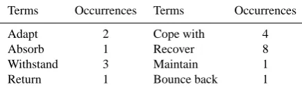
Table 1. Terms used in the definitions of resilience in rela-tion to natural hazards, according to the definirela-tions selected in Mayunga (2007).
Terms Occurrences Terms Occurrences Adapt 2 Cope with 4 Absorb 1 Recover 8 Withstand 3 Maintain 1 Return 1 Bounce back 1
in its heuristic potential or its hermeneutic power and not in its purely practical efficiency. Nevertheless, resilience was immediately seen as an opportunity to enrich or even renew the management systems such as the policies contributing to reduce hazards and disasters. It must be emphasized that hazard research can hardly be independent from this passage from theory to practice.
These formalizing difficulties have an immediate conse-quence: in practice, many interpretations are incompatible. For example, when the very poor are the first to come back to the disaster areas after an impact, some see a proof of their resilience, others of their vulnerability, others still of the metropolitan system’s inertia or of the captivity of those populations (even if those categories do not necessarily cor-respond to reality; Reghezza et al., 2012). Moreover, in the literature, it becomes evident that, to be resilient, a system must, at the same time, be redundant, diversified and effi-cient; autonomous and collaborative; i.e., stiff, flexible and adaptable; capable of learning from the past and of facing future uncertainties. To some extent these characteristics are contradictory. Thus concerning the different linkage between resilience, vulnerability and adaptive capacity concept, a di-dactic review has been already done (Cutter et al., 2008).
Nevertheless, beyond this polysemy, there are many com-mon definitions. For instance, some articles outline numer-ous resilience definitions (Mayunga, 2007) and it appears that there are many redundancies (Table 1). So, thanks to the study of many definitions in different disciplines, we have de-fined urban resilience, in our context of research, as “the abil-ity of a cabil-ity to absorb disturbance and recover its functions after a disturbance” (Lhomme et al., 2011). In other words, urban resilience can be defined as the ability of a city to oper-ate in a degraded mode (absorption capacity) and to recover its functions, despite the fact that some urban components are disrupted (recovery capacity; Lhomme et al., 2011).
3 Methodology and tool for assessing urban resilience based on system approach of the city
To go beyond the definition debate concerning resilience, a focus on the research object is needed.
Yet, if the concept of a city seems perfectly clear to ev-eryone, defining this concept is complex. For instance, the definition of a city has been approached in a number of dis-tinct ways. Among the more important viewpoints that have been adopted are the economic, the sociological, the cultural and the historical. There is no one standard definition of a city: the term may be used for a town possessing city sta-tus; for an urban locality exceeding an arbitrary population size; or for a town dominating other towns with particular re-gional economic or administrative significance. System ap-proach tends to overcome these segmentations and level of complexity. Indeed, a system approach proposes a common language for different disciplines and can be considered a good way to study complex system (Batty, 2009).
3.1 Urban networks: a major issue for flood resilient cities
Urban resilience is often defined as “the capacity of a city to face devastating event reducing damage at minimum” (Cam-panella, 2006). This definition emphasizes the operational aspect of resilience that would tend to reduce the damage caused by a disturbance; but in this context resilience doesn’t really appear as a new concept, because city managers have tended to reduce damages for several decades. Moreover, this definition of resilience cannot be linked directly with other disciplines which use a resilience concept.
Concerning flood hazards, resilience concepts are com-prised of individual preventive and emergency measures at building scale and a land use policy to adapt building ac-tivities to floods (Pasche and Geisler, 2005). That is why, for some researchers, flood preparedness is mainly a matter of flood-resilient building and hazard awareness. So, in the current discussion on flood resilient cities, a strong empha-sis is placed on improving the flood performance of build-ings. Nevertheless, a resilience concept was also applied to flood risk management by adopting a systems approach (De Bruijn, 2005). In this context, the city has to be considered as an entity composed by different elements and not merely as a set of concrete buildings. Henceforth, it is acknowledged that it is an interesting and useful exercise to think of a city as a system (Zevenbergen et al., 2010).
A system model has been designed for studying cities and for modeling their functions. In this model, the city is composed of different elements such as population, compa-nies, public infrastructures, housing and networks (Lhomme et al., 2010). These components are supported by the en-vironment and they are organized by governance. More-over, urban systems are subjected to influences from the external world (systems environment), for example,
eco-nomic shocks, technological advances, and political changes. System relations with its environment are characterized by exchanges with other cities (raw materials, manufactured goods...) and of course the waste produced by activities and population (Lhomme et al., 2010).
In this system, the power and influence of a city are based on its ability to provide a safe environment for its citizens and an efficient support for its activities. Urbanity is then linked with resources accumulation enabled by economic activities that depend on powerful networks (Blancher, 1998). More-over, networks play an important part in crises and not always for positive aspects. Recent experience feedbacks have high-lighted the negative role of technical networks during a crisis. The first manifestation is the extension of networks that prop-agate the failure. For instance, if an urban heating network encounters a disruption, the whole district would be deprived of heating, whereas if each building has its own heating de-vice, an impact would be restricted to the building. So, eval-uating network infrastructures for potential vulnerabilities is an important component of strategic planning, particularly in the context of managing and mitigating service disruptions (Matisziw et al., 2008). For instance, the reliability and rapid restoration of the electric grid in particular is necessary to support the needs of the population within the disaster area effectively (Winkler et al., 2010).
Concerning flood hazards, experiences coming from Great Britain give good examples of technical networks vulnera-bility to flooding. The severe flooding in June and July 2007 left many homes and businesses without power and water for days. Gloucestershire was particularly badly hit, with half a million people threatened by power cuts and water shortages as Walham sub-station and Mythe water treatment works flooded. At Walham sub-station, after almost 10 h the site was secured and the fire and rescue services began pumping water out of the critical area. The work was completed just in time, narrowly averting a major shutdown of the site, which could have left half a million homes without power. Cas-tle Mead sub-station was less fortunate and power to 42 000 homes was cut whilst temporary defenses were put in place (EA-UK, 2007).
The experiences at Walham, Castle Mead and Mythe have highlighted the very real need to protect technical networks from the impact of flooding. Whilst Gloucestershire was par-ticularly badly affected, many other parts of the country also suffered major disruption. In Yorkshire alone, 136 sewage treatment works, serving two million people, were flooded during June. Mythe water treatment works was also severely affected. The site supplies water to around 350 000 people in Tewksbury, Cheltenham and Gloucester. Up to half a me-ter of flood wame-ter covered the site, flooding buildings, offices and equipment, and preventing staff from safely returning for three days (EA-UK, 2007).
networked systems and at the same time the operability of these systems can be vulnerable to disasters, there is a need to understand how networked systems are resilient. When im-proving urban resilience, imim-proving the networks’ resilience seems to be a necessary (but not sufficient) condition. In-deed, networks are at the same time vectors of development and vectors of failure propagation. If a city is to face risks, it must have resilient networks to ensure its basic functioning and to foster a quick recovery.
The methodology designed here for analyzing urban re-silience suggests focusing on a technical network rere-silience analysis. Thus, thanks to this focus on urban technical net-works, it is possible to identify the most critical locations and then to prioritize actions to protect these locations, in partic-ular if these locations include many critical infrastructures.
3.2 A framework for assessing the resilience level of the urban networks
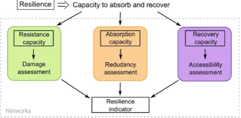
Using the resilience definition, three capacities need to be analyzed for studying resilience: absorption capacity, recov-ery capacity and resistance capacity. Absorption capacity is the ability of a network to redistribute flows toward unaged parts of the network when this network is partly dam-aged. In other words, a resilient network should be redundant (Ouyang et al., 2012). Furthermore, this network should not be completely damaged (and consequently out of service) de-spite a good redundancy. So, a resilient network should also be resistant. Recovery capacity of a technical network cor-responds to its ability to restore damaged components. This capacity may correspond to the time required for restoration of damaged components. Recovery capacity is directly re-lated to network damages because if the network is highly damaged, it will be difficult to quickly restore all the dam-aged components. In fact, absorption capacity and recovery capacity can be considered as dependant of resistance capac-ity. That is why resistance capacity has been introduced as the third capacity requirement for network resilience (Fig. 1), in addition to absorption and recovery capacities that are di-rectly involved in resilience definition.
For each capacity, some methodological choices have been undertaken. Thus, absorption capacity analysis is fo-cused on networks’ redundancy assessment. Resistance ca-pacity analyzes dysfunctions induced by damaged compo-nents and takes into account interdependencies between net-works (Lhomme et al., 2011). Recovery capacity analysis considers accessibility between restoration center and dam-aged components.
This framework is quite similar to existing approaches’ focus on infrastructure resilience analysis (Bruneau et al., 2003; Ouyang et al., 2012). Yet, beyond similarities, these approaches are quite different in terms of infrastructures studied (Bruneau et al., 2003) or in terms of methods used for implementing these approaches (Ouyang et al., 2012).
8 1
Figure 1: Strategy for assessing networks 2 resiliency
2
For each capacity, some methodological choices have been undertaken. Thus, absorption
3
capacity analysis is focused on networks redundancy assessment. Resistance capacity
4
analyzes dysfunctions induced by damaged components and takes into account of
5
interdependencies between networks (Lhomme et al., 2011). Recovery capacity analysis
6
considers accessibility between restoration center and damaged components.
7
This framework is quite similar with existing approaches focus on infrastructure resilience
8
analysis (Bruneau et al., 2003; Ouyang et al., 2012). Yet, beyond similarities these approaches
9
are quite different in terms of infrastructures studied (Bruneau et al., 2003) or in terms of
10
methods used for implementing these approaches (Ouyang et al., 2012).
11
3.3 A web GIS for implementing the overall methodology
12
A Geographic Information System (GIS) is required to implement methodology presented
13
above. A GIS is a mapping software that provides spatial information by linking locations
14
with information about that location. It provides the functions and tools needed to efficiently
15
capture, store, manipulate, analyze, and display the information about places and things. First,
16
this research focuses on urban technical networks. Technical networks (such as transportation
17
networks, the Internet…) connect points in geographic space. Thus, the nodes and the edges
18
(lines) of these networks are real physical constructs occupying particular positions in space.
19
So, researchers find that there are strong signatures in these networks of topography and use
20
patterns, giving the networks shapes that are quite distinct from one another and from
non-21
geographic networks (Gastner & Newman, 2006).
22
Secondly, it is well known that GIS can be used to analyze the spatial component of risk and
23
it is clear that risk assessments have an important spatial component. For instance, to better
24
respond to post disaster activities geographic information system (GIS) technology provides a
25
Fig. 1. Strategy for assessing networks resiliency.
3.3 A web GIS for implementing the overall methodology
A Geographic Information System (GIS) is required to im-plement the methodology presented above. A GIS is a map-ping software that provides spatial information by linking lo-cations with information about that location. It provides the functions and tools needed to efficiently capture, store, ma-nipulate, analyze, and display the information about places and things. First, this research focuses on urban technical networks. Technical networks (i.e., transportation networks, the Internet) connect points in geographic space. Thus, the nodes and the edges (lines) of these networks are real phys-ical constructs occupying particular positions in space. So, researchers find that there are strong signatures in these net-works of topography and use patterns, giving the netnet-works shapes that are quite distinct from one another and from non-geographic networks (Gastner and Newman, 2006).
Secondly, it is well known that GIS can be used to analyze the spatial component of risk and it is clear that risk assess-ments have an important spatial component. For instance, to better respond to post-disaster activities, geographic infor-mation system (GIS) technology provides a logical tool for integrating the necessary information and contributing to pre-paredness, rescue, relief, recovery and reconstruction effort (Gunes and Kovel, 2000; Lembo et al., 2008). That is why a GIS has been designed in order to analyze the resilience of urban technical networks and to finally implement the overall methodology.
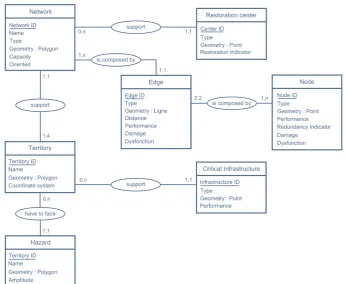
Fig. 2. Entity-relationship model for the Web-GIS database.
analysis; and to conclude a synthesis of the different results with the introduction of critical infrastructures location anal-ysis.
4 Application: Orleans road network absorption capacity
Data on technical networks are difficult to obtain, especially at the city level. In the city of Orl´eans, networks are managed by several private institutions, which are reluctant to provide data for both security (terrorism, sabotage) and competitive reasons. That is why the city of Orl´eans is involved with the local state authority for the crisis management of networks infrastructures.
However, road network data can be easily obtained. More-over, absorption capacity can be studied using few data, be-cause this capacity can be considered as a network structural property, which is not focused on flow dynamics and spe-cific scenarios (for instance floods hazards) but on network topology (Gleyze, 2005). In this context, the first step of our methodology is generally to study the absorption capacity of road networks.
4.1 Structural analysis of technical networks
Technical networks – such as power grid networks, internet and pipelines – are more and more important in modern
so-ciety. These networked infrastructures are considered as a branch of the complex networks which also include biolog-ical and social networks. Related research originating from the complex networks have attracted increasing attention in recent decades (Zhang et al., 2012). In particular, there has been considerable interest within the physics community in the analysis of this complex networks (Zhang et al., 2012). Thus, extensive research into the properties and behaviors of complex systems has uncovered surprising commonalities among the topologies of different systems. This exploration has also underscored the need to move beyond reductionist approaches, trying, instead, to understand the behavior of a system as a whole. Attempts to explain similarities have led to the ongoing development and refinement of network mod-els and graph–theoretical analysis techniques with which to characterize and understand complexity (for instance, scale free and small world properties).
Fig. 3. Web-GIS user interface: The map (1); The menu (2); Options of each menu (3); Different tools (4); Information about map objects (5).
relationships (I(v,j)) to go from one point (v) to the neighbors of the neighbors of this point
1(Γ²(v)). So, it is proposed to count all the independent paths linking one point and the set of
2neighbors of its neighbors and then to divide this proportion by the number of links that could
3possibly exist between them. This is a good global indicator to characterize redundancy of a
4network, but it presents some abnormalities at a local scale due again to planar configuration
5of technical networks (Fig. 4). That is why this indicator is not useful at the local scale. In
6fact, to correct these abnormalities, it is possible to average the proportion of independent
7paths linking one point and the set of neighbors of its neighbors (V[Γ²(v)] is the number of
8neighbors of neighbors). This average indicator is the first indicator used to analyze
9absorption capacity (Indicator 1(v)) [1].
1011
Figure 4: correction of some abnormalities.
12Nevertheless, this indicator is not sufficient to characterize technical network redundancy.
13Indeed each point is considered as an origin or a destination point, but in many cases these
14points are used as “connection points”. So, technical networks redundancy is highly
15concerned by transitivity issues. Thus, redundancy corresponds to a second indicator
16corresponding to the number of independent path between the neighbors of the neighbors of a
17point when this point is disturbed (Indicator 2(v)) [2]. Each indicator considers the quality of
18alternatives (a comparison with the best path, for instance with the shortest path
19)))). Moreover, this indicator can be based on other criteria than distance: capacity 20
for water network, impedance for electricity network… It is also possible to adapt these
21indicators to work at another scale (V[Γ
3(v)]; V[Γ
4(v)]; …; V[Γ
n(v)];)
22) ) ∑ ))) )) )
[1]
)
) ) ) ) ∑
)) ( ))) )
[2]
4.3 Redundancy of Orleans road network
23
Fig. 4. Correction of some abnormalities.
and performance in networks has implications for manag-ing and mitigatmanag-ing risks related to network attacks or failures (Garber, 2000), whereas other researchers used a topological model of cascading failure and argue that attacks on nodes (buses) transporting smaller amounts of power can result in disproportionately large failures (Wang and Rong, 2009).
This focus on topology (structural analysis) is relatively new. While they do provide insight into network structure, these studies neglect the equations that govern flows (Hines and Cotilla Sanchez, 2010). In fact, dimensioning methods, based on flow modeling, are used by engineers and techni-cians to decide which solution is best for the construction of a network. They consider the environment (i.e., temper-atures, soil nature, soil use), the population supplied by the service (i.e., number, type, habits), the techniques and the costs associated. The analysis of all those data is supposed to lead to the best solution. The methods used by engineers and technicians to determine the characteristics of the net-work take into account the needs (assessed with the social context), the environment (including the risks), the different techniques available, and the costs. Traditionally, the
princi-ple in technical networks hazard assessment is a comparison between the flow during normal working conditions and un-der disruption. This traditional approach based on flow can be considered as functional analysis, whereas relatively new approach based on topology can be considered as structural analysis (Gleyze, 2005).
4.2 New redundancy indicators for assessing networks absorption capacity
Concepts coming from graph theory are fundamental to as-sess observable differences in network topology and flow types. A graph is a very simple structure consisting of a set of vertices and a family of lines, called edges (undirected) or arcs (directed), each of them linking some pair of vertices.
A network is notably characterized by a specific capacity to absorb different type of disturbance. Most of the frequent disruptions are always locally absorbed by the networks and the end users remain unaware of their occurrence (Due˜nas-Osorio, 2005). This fact results from the ability of the net-works to redistribute the flow at the location of the disruption. This is a typical resilience capacity that allows networks to
operate in a degraded mode. Thus, network geometric prop-erties limit adaptive capacity of this network. Indeed, net-work configuration (structural property) determines the num-ber of alternative paths to the disruptions of one or several components. This network property can be considered as the redundancy of the networks. In fact, redundancy is a com-mon property for characterizing resilient networks (Serulle, 2010).
So, the objective here is to investigate network representa-tions of the technical networks from a topological (structural) perspective in order to study redundancy of these networks and consequently to discriminate nodes (or edges) in terms of redundancy.
Some indicators already exist to discriminate nodes (or edges) in terms of redundancy. For instance, the clustering coefficient, also known as transitivity, is a typical property of acquaintance networks, where two individuals with a com-mon friend are likely to know each other (Wasserman and Faust, 1994). The clustering coefficient is a measure of the degree to which nodes in a graph tend to cluster together and characterize the cohesiveness of the neighborhood of a node. Thus, this indicator is close to the redundancy characteriza-tion. Such a quantity is not suited to characterize the local properties of a planar graph, since by a simple counting of the number of triangles present in the graph, it is not possible to discriminate different technical network topologies. For instance, there are cases as diverse as trees, square-meshes and honey-comb meshes, all having the same clustering co-efficient equal to zero. Researchers have proposed a more general measure of the structure of cycles (not restricted to cycles of length 3) in planar graphs, the so-called meshed-ness coefficient (Buhl et al., 2006). Nevertheless, this last in-dicator is a global inin-dicator and it can’t discriminate nodes (or edges) in terms of redundancy.
The redundancy ratio, defined in (Due˜nas-Osorio, 2005), assesses the redundancy of a network. In this research, redun-dancy is characterized by the number of “independent” rela-tionships (I (v, j)) to go from one point (v) to the neighbors of the neighbors of this point (02(v)). So, it is proposed to count all the independent paths linking one point and the set of neighbors of its neighbors and then to divide this propor-tion by the number of links that could possibly exist between them. This is a good global indicator to characterize redun-dancy of a network, but it presents some abnormalities at a local scale due again to planar configuration of technical net-works (Fig. 4). That is why this indicator is not useful at the local scale. In fact, to correct these abnormalities, it is pos-sible to average the proportion of independent paths linking one point and the set of neighbors of its neighbors (V[02(v)] is the number of neighbors of neighbors). This average indi-cator is the first indiindi-cator used to analyze absorption capacity (Indicator 1 (v)); Eq. (1).
Nevertheless, this indicator is not sufficient to characterize technical network redundancy. Indeed each point is consid-ered as an origin or a destination point, but in many cases
these points are used as “connection points”. So, technical network redundancy is highly concerned by transitivity is-sues. Thus, redundancy corresponds to a second indicator, corresponding to the number of independent paths between the neighbors of the neighbors, to a point when this point is disturbed (Indicator 2 (v)); Eq. (2). Each indicator considers the quality of alternatives (a comparison with the best path, for instance with the shortest path Min(σ (I (v, j ))). More-over, this indicator can be based on other criteria than dis-tance: i.e., capacity for water network, or impedance for elec-tricity network. It is also possible to adapt these indicators to work at another scale (V[03(v)];V[04(v)]; ...; V[0n(v)]);
Indicator 1= 1
V[02(v)]
X
j 02;j6=v
σ (I (v, j ))
Min(σ (I (v, j ))) (1)
Indicator 2= 1
(V[02(v)])(V[02(v)] −1)
X
i,j 02(v);i,j6=v
σ (I (i, j ))
Min(σ (I (i, j ))) (2)
4.3 Redundancy of Orleans road network
Orl´eans is a city in north-central France, about 130 km south-west of Paris. It is the capital of the Loiret department and of the Centre region. Orl´eans is located on the Loire River. The Loire River crosses the agglomeration from east to west. In Orl´eans, the Loire is separated by a submerged dike into the “Grande Loire” to the north, no longer navigable, and the “Petite Loire” to the south. This dike is just one part of a vast system of construction that previously allowed the Loire to remain navigable. 14 municipalities (over 22 from Orl´eans’ administrative district) are concerned by the Loire River floods, corresponding to about 19 000 households which could experience water levels higher than 1.50 m. The city of Orl´eans was completely flooded three times in the 19th century. More recently, in 2003, the Loire upstream Orleans partly overflowed some urban and countryside areas.
Today, Orleans is committed to reducing its vulnerability by taking new adaptive approaches to sustainable flood risk management and flood risk management planning. During recent years, the city of Orleans has been working on flood issues through information campaigns, spreading knowledge about floods in the communities and raising awareness. It is also putting in place rescue and recovery plans for the popu-lation and public services. The aim is to minimize damages and enable the city to recover as quickly as possible after flood events. In fact, Agglomeration of Orleans is one of the most advanced territories in France in terms of vulnerabil-ity concerns. Flood managers understood very early that, in a context of a diked system, trying to tackle the question of residual risk (e.g. flood defense failure) is essential to pro-duce resilient cities. So, they have been interested in an ap-plication of the methodology on their territory.
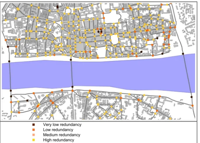
Fig. 5. Orleans road networks redundancy; the city of Bou (left) and the city of Chanteau (right).
Fig. 6. Orleans road networks redundancy analysis shows the weak redundancy of this network close to bridges.
carried out for each indicator. Thus two different maps have been obtained for each city. Then, the results have been ag-gregated to obtain a single map for each city. For this, for each node (corresponding to road intersections), the less re-dundant classification is chosen to characterize redundancy. Thus, the two maps below show the differences of redun-dancy between the two cities in a very simple way (Fig. 5). It is important to understand that the Agglomeration of Orl´eans is composed of thousands of nodes and it is strictly
impossi-ble to detect these structural differences without the indica-tors developed in this research.
Secondly, a specific study has been conducted on the city of Orleans. In this analysis, the road network has been sim-plified in order to focus study on the main road of Orl´eans. Thus, the Orl´eans road network appears to be well meshed and redundant, like most of the French cities. Nevertheless, the redundancy is quite low and close to Orl´eans’ different bridges (Fig. 6).
That is why it is important in terms of risk management to pay special attention to these different bridges which link the north part of the city with the south part. Indeed, these bridges can be easily disconnected and consequently the north and south part of Orl´eans can also be easily discon-nected. The objective for risk managers is to avoid isolation of these two parts. That is why Orl´eans flood managers have recently begun a more focused analysis about accessibility of these bridges during flooding.
5 Conclusion
This paper proposes a methodology to improve urban re-silience using Web-GIS. This methodology is based on a sys-tem approach of cities. This approach emphasizes the impor-tance of networks concerning urban resilience. Thus, princi-ples and assumptions finally lead to the analysis of how urban networks are able to face natural hazards. This kind of ap-proach is quite new. So, in this article we have demonstrated how networks were the dorsal spine of cities’ development, and how they play an important part in resilience. Indeed, economic activities, populations, services and public infras-tructures depend on the efficiency and the reliability of these networks. Thus we can admit that powerful networks are a prerequisite to a powerful city.
Many results have already been obtained and contribute to the implementation of the resilience concept in an opera-tional way: an overall methodology about urban resilience has been developed; a framework concerning urban net-works’ resilience has been implemented; specific structural indicators have been designed in order to assess networks redundancy; these indicators have been tested in real case study; and an operational Web-GIS prototype has also been designed.
To conclude, applications on the Orleans road network at-test that methodology and tools are operational. In this con-text, a strong emphasis is placed on urban planning in or-der to improve risk management. This research provides the opportunity to deal with these issues. Nevertheless, this re-search is focused on technical aspect. In fact, social and or-ganizational resilience must be assessed as well to ensure a more holistic approach necessary to improve resilience. Moreover, structural analysis of the road network presented here is just a first step. Others technical networks need to be analyzed and designed indicators need to be adapted to their main characteristics. In-depth analysis, including resistance
capacity analysis and recovery capacity analysis, is also un-derway in another territory.
Acknowledgements. The authors wish to acknowledge with sincere
appreciation the reviewers for their comments.
Edited by: B. Barroca
Reviewed by: two anonymous referees
References
Albert, R., Albert, I., and Nakarado, G.: Structural vulnerability of the North American power grid, Phys. Rev. E., 69, 4 pp., 2004. Ashley, R., Blanksby, J., Chapman, J., and Zhou, J. J.: Towards
Integrated Approaches to Reduced Flood Risk in Urban Areas, edited by: Ashley R., Garvin S., Pasche E., Vassilopoulos A., and Zevenbergen C., Advances in Urban Flood Management, 415– 432, 2007.
Batty, M.: Cities as Complex Systems: Scaling, Interaction, Net-works, Dynamics and Urban Morphologies, in: Encyclopedia of complexity and systems science, edited by: Meyers R. A., Springer, 1041–1071, 2009.
Blancher, P.: Risques et r´eseaux techniques urbains, Centre d’´etudes sur les r´eseaux, les transports, l’urbanisme et les constructions publiques (CERTU), 1998.
Brand, F. S. and Jax, K.: Focusing the meaning(s) of resilience: re-silience as a descriptive concept and a boundary object, Ecol. Soc., 12, 23, 2007.
Bruneau, M., Chang, S. E., Eguchi, R. T., Lee, G. C., O’Rourke, T. D., Reinhorn, A. M., Shinozuka, M., Tierney, K., Wallace, W. A., and VonWinterfeldti, D.: A Framework to Quantitatively Assess and Enhance the Seismic Resilience of Communities, Earthq. Spectra, 19, 737–738, 2003.
Buhl, J., Gautrais, J., Reeves, N., and Sole, R. V.: Topological pat-terns in street networks of self18 organized urban settlements, Physica A, 49, 513–522, 2006.
Campanella, T. J.: Urban Resilience and the Recovery of New Or-leans, J. Am. Plann. Assoc., 141–146, 2006.
Carpenter, S., Walker, B., Anderies, M., and Abel, N.: From metaphor to measurement: Resilience of what to what?, Ecosys-tems, 8, 765–781, 2001.
Comfort, L. K., Boin, A., and Demchak, C.: Designing Resilience. Preparing for Extrem Events, Pittsburgh, University of Pittsburgh Press, 2010.
Cutter, S., Barnes, L., Berry, M., Burton, C., Evans, E., Tate, E., and Webb, J.: A place-based model for understanding commu-nity resilience to natural disasters, Global Environ. Chang., 18, 598–606, 2008.
De Bruijn, K. M.: Resilience and flood risk management, a system approach applied to lowland rivers, thesis, Delft university, 220 pp., 2005.
Due˜nas-Osorio, L.: Interdependent response of networked sys-tems to natural hazards and Intentional disruptions, Dissertation, Georgia Institute of Technology, Atlanta, Georgia TechLibrary, 2005.
Folke, C.: Resilience: The emergence of a perspective for social– ecological systems analyses, Global Environ. Chang., 253–267, 2006.
Gallopin, C. G.: Linkages between vulnerability, resilience, and adaptive capacity, Global Environ. Chang., 16, 293–303, 2006. Garber, L.: Denial-of-service attacks rip the internet, Computer,
April, 33, 12–17, 2000.
Gastner, M. and Newman, M. E. J.: The spatial structure of net-works, Eur. Phys. J. B, 49, 247–252, 2006.
Gleyze, J. F.: La vuln´erabilit´e structurelle des r´eseaux de transports dans un contexte de risque, Th`ese de doctorat, Universit´e Paris VII, Laboratoire COGIT-IGN, 826 pp., 2005.
Gunes, A. E. and Kovel, J. P.: Using GIS in emergency management operations, J. Urban Plann. Dev., 126, 126–149, 2000.
Hines, P. and Cotilla-Sanchez, E.: Do topological models provide good information about electricity infrastructure vulnerability?, Chaos, 20, 033122, 2010.
Holling, C. S.: Resilience and stability of ecological systems, An-nual Review of Ecological System, 4, 1–23, 1973.
Kinney, R., Crucitti, P., Albert, R., and Latora, V.: Modeling cas-cading failures in the North American power grid, Eur. Phys. J. B, 46, 101–107, 2005.
Klein, R. J. T., Nicholls, R. J., and Thomalla, F.: Resilience to natu-ral hazards: How useful is this concept?, Environmental Hazards, 5, 35–45, 2003.
Lembo Jr., A., Bonneau, A., and O’Rourke, T.: Integrative technolo-gies in support of GIS-based postdisaster response, Nat. Hazards Rev., 9, 61–69, 2008.
Lhomme, S., Serre, D., Diab, Y., and Laganier, R.: GIS development for urban resilience, Sustainable City 2010, 14–16 April 2010, La Coru˜na, Spain, 2010.
Lhomme, S., Serre, D., Diab, Y., and Laganier, R.: A Methodol-ogy to Produce Interdependent Networks Disturbance Scenarios, Vulnerability, Uncertainty, and Risk: Analysis, Modeling, and Management Proceedings of the ICVRAM 2011 and ISUMA 2011 Conferences, 724–731, 2011.
Manyena, S. B.: The concept of resilience revisited, Disasters, 30, 434–450, 2006.
Matisziw, T. C., Murray, A. T., and Grubesic, T. H.: Exploring the vulnerability of network infrastructure to disruption, Ann. Re-gional Sci., 43, 307–321, 2008.
Mayunga, J. S.: Understanding and Applying the Concept of Com-munity Disaster Resilience: A capital-based approach, Land-scape Archit., 22–28, 2007.
Ouyang, M., Due˜nas-Osorio, L., and Min, X.: A three-stage re-silience analysis framework for urban infrastructure systems, Structural Safety, 2012.
Pasche, E. and Geisler, T. R.: New strategies of damage reduction in urban areas proned to flood, Urban flood management, in Urban Flood Management, edited by: Szollosi-Nagy, A. and Zevenber-gen, C., 101–117, 2005.
Reghezza, M., Rufat, S., Lhomme, S., Djament-Tran, G., and Leblanc A.: Resilience use and abuse, Cybergeo, 2012. Serulle, N. U.: Transportation Network Resiliency?: A Fuzzy
Sys-tems Approach, Master Thesis, Utah State University, 95 pp., 2010.
Sole, R. V., Rosas-Casals, M., Corominas-Murtra, B., and Valverde, S.: Robustness of the European power grids under intentional at-tack, Phys. Rev. E, 77, 026102, 2008.
Wang, J. W. and Rong, L. L.: Cascade-based attack vulnerability on the US power grid, Safety Science, 47, 1332–1336, 2009. Wasserman, S. and Faust, K.: Social network analysis: Methods
and applications (structural analysis in the social sciences), Cam-bridge University Press, 2004.
Winkler, J., Due˜nas-Osorio, L., Stein, R., and Subramanian, D.: Performance assessment of topologically diverse power systems subjected to hurricane events, Reliab. Eng. Syst. Safe., 95, 323– 336, 2010.
Zevenbergen, C., Cashman, A., Evelpidou, N., Pasche, E., Garvin, S., and Ashley, R.: Urban Flood Management, CRC Press, 340 pp., 2010.
![Fig. 3. Web-GIS user interface: The map (1); The menu (2); Options of each menu (3); Different tools (4); Information about map objects(5).10 absorption capacity (Indicator 1(v)) [1]](https://thumb-us.123doks.com/thumbv2/123dok_us/8377918.1384446/6.595.90.513.69.291/interface-options-different-information-objects-absorption-capacity-indicator.webp)