http://www.sciencepublishinggroup.com/j/earth doi: 10.11648/j.earth.20190805.13
ISSN: 2328-5974 (Print); ISSN: 2328-5982 (Online)
An Alternative Structural Model for the Development of the
Cape Fold Belt Syntaxis and Groundwater Potential
Blignault Hendrik Johan
1, Theron Johannes Nicolaas
21
Independent Researcher
2Department of Earth Sciences, University of Stellenbosch, Stellenbosch, South Africa
Email address:
To cite this article:
Blignault Hendrik Johan, Theron Johannes Nicolaas. An Alternative Structural Model for the Development of the Cape Fold Belt Syntaxis and Groundwater Potential. Earth Sciences. Vol. 8, No. 5, 2019, pp. 277-284. doi: 10.11648/j.earth.20190805.13
Received: September 11, 2019; Accepted: October 7, 2019; Published: October 25, 2019
Abstract:
The syntaxis separates the eastern and western branches of the Cape Fold Belt, South Africa. A satisfactory and holistic solution remains unresolved. This investigation is to develop an alternative hypothesis for the development of the syntaxis. Because macroscopic fold structures are considered most relevant in resolving a tectonic solution on subcontinental scale, the fold hinge traces of macroscopic structures were comprehensively compiled from published geological maps. The fold patterns of the eastern and western fold belt branches are separated across the hypothetical Ceres lineament without any identified interaction. The en echelon fold pattern of the western branch is interpreted as the result of northern movement of a lower crustal block. The eastern branch is dominated by north-verging over folding and thrusting in the east and westwards towards the Ceres lineament the folds are predominantly upright. It is suggested that differential basal slip causes the fold belt to terminate against the lineament with a sinistral rotation that is also accommodated by the sinistral Villiersdorp ductile shear zone. It appears that basal slip retardation increases from east to west. The two fold belt branches were developed in adjacent crustal blocks that reacted differently to northward tectonic transport driven by subduction and accretion further south along southern Gondwana. The hypothesis is testifiable. The structural investigation revealed the hitherto unknown existence of special structural situations with wellfield potential for groundwater that remains to be tested by drilling.Keywords:
Cape Fold Belt, Syntaxis, Structural Kinematics, Groundwater Wellfield1. Introduction
The Permian Cape Fold Belt, South Africa, comprises East- West (EW) and North-North-West (NNW) fold branches. These fold belt branches, involving Ordovician to Permian platform sediments, meet at the syntaxis where the mountain ranges converge. A review of the historic literature indicates diverse structural models for the temporal and structural interaction between the two fold belt branches. This investigation aims to develop an alternative structural-tectonic explanation for the development of the Cape Syntaxis. With this in mind, the traces of hinge zones of macroscopic fold structures in the area around the syntaxis,
were comprehensively compiled and interpreted
kinematically. The investigation involved the compilation of virtually, if not all the macroscopic structures from the 1:50 000, 1:125 000 and 1:250 000 geological maps published by
the Geological Survey of South Africa (now the Council for Geoscience). It is thought that the large structures are most relevant in the context of a subcontinental problem. Critical areas were supplemented with information from high resolution satellite images and various publications referenced below. Limited fieldwork was carried out in selected areas to improve and confirm the information.
wrench faulting [4]. Using an earlier structural compilation [5], it was speculated that the syntaxis can be explained by the movement and rotation of microplates situated on both sides of the syntaxis [6]. De Beer’s conclusion that simultaneous northwards and eastwards compression converged in the syntaxis area with the consequence that intermediate (NE) fold trends developed [7, 8]. The latter is based firstly on observations of cross folds interpreted as the result of simultaneous contraction along two orthogonal directions (bulk constrictional deformation), and secondly on experimental patterns produced for “simultaneous shortening along perpendicular directions at unlike magnitudes”. The Cape syntaxis is also explained by a model of refolding of the east-west trending folds of the EW fold branch in response to dextral transpressional shearing acting across the Cape Fold Belt; in effect producing an oroclinal bend [9].
Extensive literature is also available on mainly the eastern part of the EW branch that is dominated by north verging
over folding and thrusting. A more recent contribution provides an overview of the entire Cape Fold Belt [10].
This investigation lead, as an unintended objective, to the realization that interesting structural situations are locally developed with possible groundwater potential on wellfield scale.
2. The Syntaxis
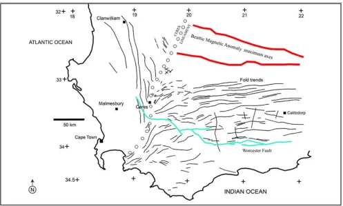
The pattern of the macroscopic fold hinge traces (Figure 1) shows a separation between the north-north-west trending and the east-west to north-east trending fold sets of the two domains. A line is drawn separating the two fold-trend domains and referred to here as the Ceres lineament. Of note is that there is no bending or merging of macroscopic fold trends from the one fold branch towards the other (nonrotational arc or oroclinal bending [12]. Nor was superimposed folding on macroscopic scale, of one fold branch onto the other, identified.
Figure 1. The pattern of the macroscopic fold-hinge trends shows a clear separation between the north-north-west trending and the east-west to north-east trending folds of the two domains both sides of the syntaxis. A line is drawn separating the two fold-trend domains and is referred to as the Ceres lineament. Note that there is no bending or merging of macroscopic fold trends from the one fold branch into the other. Nor was superimposed folding on macroscopic scale identified. The Ceres lineament approximately marks the western termination of the Beattie magnetic anomaly that is modelled as a mid-crustal linear feature within the eastern domain.
The associated faulting also differs across the lineament. Spatially associated with the NNW fold branch, is an array of north-west striking strike-slip faults of a brittle nature. The apparent displacement of inclined beds along the faults shows both dextral and sinistral separation (Figure 2). In the eastern domain north-east trending strike-slip faults (also of brittle nature) with consistent dextral separation, are developed south of the Worcester fault (Figure 2).
Whereas the eastern fold branch adjacent to the syntaxis, is fully covered by the Paleozoic platform sediments, the western fold branch is only partially covered by the cover sediments. The southern part of the western domain comprises a concentration of batholiths and plutons (Figure 2) of the Late Precambrian Cape Granite Suite [13].
1) which is modelled as a mid-crustal (ca. 10 km – 20 km depth) linear feature within the eastern domain [14]. A lower crustal discontinuity along the lineament is suspected.
Two important fault zones, the Colenso and Piketberg- Wellington fault zones (Figure 2) are developed in the Pan– African Saldania Belt, separating the major tectono- stratigraphic terranes in the Malmesbury area [13, 15, 16].
These Neoproterozoic basement fault zones also displace units of the Table Mountain Group, implying that they were re-activated in the western domain during the Cape orogenic cycle. Both fault zones as expressed in the cover sediments, terminate at or near the Ceres lineament (Figure 2).
The Ceres lineament separates the two adjacent crustal domains each with distinctive geological characteristics.
Figure 2. The major fault systems. The basement Colenso and Piketberg-Wellinhton faults, of a more ductile cataclastic nature, are associated with the Pan-African Saldanian orogeny and subsequently reactivated to displace sandstone units of the Table Mountain Group; these fault zones are developed in the western domain and terminate at or near the Ceres lineament. The faults associated with the Cape fold structures have strike-slip separation and is of a more brittle nature. Note how the Cape fault systems of the western domain differ, orientation-wise from those of the eastern domain. The Worcester Fault is a younger post-folding normal fault with southern down throw.
3. NNW Fold Belt
3.1. Review
The broad, open folding of the sandstones of the Table Mountain Group gave rise to the mountains of the Koue Bokkeveld and the Cedarberg Mountains. The NNW fold belt is areally of limited extent (Figure 3) with the folds petering out north of Clanwilliam and southwards towards Cape Town. The competency and massive bedding of the sandstones dominated the fold style of mega-structures with minor small structures. The anticlines and synclines depicted in Figure 3 are the complete mega-fold set in the fold belt. The folds characteristically have extensive strike extents with the fold axes doubly- plunging at very low angles. The folds are upright and open with fold-limb dip angles generally less than 30º-40º. North-north-west trending, up-right, mesoscopic folds were mapped in the more thinly bedded Witteberg Group sediments about 60 km southeast of
Clanwilliam [17]. North-west trending upright folds on various scales are developed in the Dwyka Group of the Tanqua Karoo [18]. Spatially associated with the folds are an array of north-west striking strike-slip faults of a brittle nature (Figure 2).
3.2. Kinematic Considerations
Figure 3. The en echelon fold structures of the NNW fold belt were compiled from published maps [17, 19, 20]. Assuming that the Ceres lineament is the projection of a buried, strike-slip fault zone in the basement, the right-stepping, en echelon fold pattern in the cover sediments, are explained by a model of bulk, dextral simple shear in the basement along the Ceres lineament (inset), but with no through-going faulting and fracturing developed in the cover sediments. Implying that a lower crustal block moved northwards by transmitted tectonic push.
It is postulated therefore that the Ceres lineament is the projection of a buried, strike-slip fault in the basement, along which localized dextral simple shear produced the NNW fold branch in the Cape Supergroup and Dwyka cover sediments. The dextral simple shear can be attributed to northwards tectonic transport of a lower crustal domain west of the Ceres lineament.
4. EW Fold Belt
4.1. Review
The EW fold belt varies in style, geometry and amount of shortening from west to east. West of Calitzdorp (Figure 4) the fold belt comprises open to close folds, upright and inclined with minor over folding and gently plunging. Eastwards, northward vergence and propagation are evident from north-verging thrust and overturned folds [23].
The synclinoria are bounded by the competent Table Mountain Group sandstones forming the Langeberg and Swartberg Mountain Ranges and incorporate gentle basin-and-dome type interference folds (type 1 interference pattern [24]). The basins depict the major Cape Supergroup
structural basins where the younger Witteberg Group sediments were preserved.
East of Barrydale in the Langeberg Mountain Range overturned anticlines and synclines are developed. The
macroscopic Barrydale interference structure is a
superimposition of an upright north- south anticline onto an overturned east-west syncline (type 2 interference pattern [24]).
basin-and-dome set of cross folds of the synclinoria.
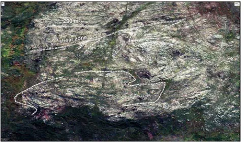
With substantial down throw along the normal Worcester fault, the EW fold belt is at a higher structural level in the south. Some differences are observed. Unusual structures such as the sinistral, ductile Villiersdorp fault and the Greyton décollement are developed. The previously unidentified Villiersdorp fault is defined by the sigmoidal curvature of fold trends (Figures 4 & 6) implying sinistral faulting after and/or during progressive folding. In the vicinity of Villiersdorp the syncline tightens markedly with well developed north-east trending, ductile shear zones along both limbs of the tight syncline (Figure 5), indicating the fault location. Along strike the Villiersdorp fault is projected as indicated by the sigmoidal curvature of the folds.
4.2. Kinematic Considerations
The EW fold belt conforms to foreland fold-and-thrust
belts accommodating the crustal contraction by differential displacement on a basal detachment [27]. Oroclinal bends are related, inter alia, to movement on strike-slip faults re-orientating structures in fold belts [12].
It is proposed here that the rotation of the east-west fold trend in a broad zone along the Ceres lineament, is due to differential displacement on a basal detachment that is being retarded progressively from east to west along the fold belt. The fold belt terminates against the Ceres lineament where the rotated fold trends approaches parallelism with the lineament; i.e. the zone of minimum basal slip. Progressive basal slip further east is accommodated by sinistral displacement of folds along ductile shear zones like the Villiersdorp fault. There may also have been movement along the Ceres lineament, but there is, however, as yet no evidence of fault movement along the lineament.
Figure 5. The sinistral, post-folding, ductile Villiersdorp fault in the cover sediments, resulted in north-north-east trending shearing on both the eastern and western limbs of the Villiersdorp syncline.
5. Structures with Groundwater
Potential
Special structural situations in the syntaxis area were identified with potential for aquifer development on wellfield scale. The tightening of folds in the Villiersdorp-Grabouw
area and the disharmonic folding above the Greyton decollément (Figure 6), resulted in the development of synclines with intense deformation in the inner arc zones (inset, Figure 6). Decoupling along the Cederberg shales accommodated the differential intensity strain between the outer and inner arc zones of the synclines. The more intense deformation structures like shears and chevron folds, observed in this area, are developed in the Nardouw Subgroup. The lowermost Goudini Formation is thinly layered sandstone and siltstone, in which chevron folds were formed (Figure 7) by inner arc compression and flexural-slip. The overlying, more massive Skurweberg Formation deformed by tangential longitudinal strain producing severe shearing and layer-parallel folding in places [24] (Figures 6 & 8). This more intense deformation with associated fracturing may have enhanced the porosity and permeability of the sandstones. The down-plunge extent of the synclines below the Bokkeveld shales as a capping, can have aquifer potential sufficiently extensive for wellfield development (Figure 6).
An artesian well was reported in the Grabouw area [25].
Figure 7. Looking north-east near Kleinmond, subvertical chevron folds are developed in the thinly bedded Goudini Formation; note the relatively unfolded Cedarberg and Peninsula Formations below.
Figure 8. Doubly plunging folds, fracturing and shearing by tangential longitudinal strain in the more massively layered Skurweberg Formation, near Grabouw.
6. Conclusion
It is postulated that the NNW and EW fold belt branches were developed in adjacent crustal blocks that reacted differently to northward tectonic transport driven by subduction and accretion further south along southern Gondwana [11]. The two crustal blocks are separated by the syntaxis that is defined as the Ceres lineament which divides the fold belt branches without known interaction. The western crustal block displays an en echelon fold set which developed in the cover sediments. The interpretation, on the basis of empirical global examples, is that a lower crustal block moved northwards with an implied buried dextral fault along the Ceres lineament. The eastern crustal block constitutes the main EW fold belt developed in the cover sediments with northern tectonic transport as evidenced by north-verging folds and thrusts best developed eastwards. It appears that basal slip retardation increases from east to west. The fold belt terminates against the Ceres lineament by supposedly further retarded basal slip as evidenced by the southern rotation of fold-hinge traces associated with sinistral ductile faulting to accommodate the progressive differential basal slip.
The hypothesis presented above is verifiable by (i) 1:50 000 geological mapping to investigate the Ceres lineament and associated Villiersdorp-type faulting, (ii) high resolution
airborne magnetic surveys to elucidate the deeper crustal structure, and (iii) seismic sections to determine the presence and differential retardation nature of basal detachments.
The structural investigation revealed the hitherto unknown existence of special structural situations with wellfield potential for groundwater that remains to be tested by drilling.
References
[1] De Villiers J., 1944. A review of the Cape Orogeny. Annals of the University of Stellenbosch, Vol. XXII, Sect. A, Nos. 1–14, pp 183-208.
[2] De Villiers J., 1956. Die drie sintaksisse in die Suidwestelike Kaapprovinsie. Tegnikon, Oktober 1956, 13 pp.
[3] Newton, A. R., 1973. A gravity folding model for the Cape Fold Belt. Transactions of the Geological Society of South Africa, 76, pp. 145-152.
[4] Cobbold, P. R., Gapais, D., Milani, E. J., Rosello, E. R., and Szatmari, P., 1992. Permo-Triassic intracontinental deformation in SW Gondwana. In: De Wit, M. J. and Ransome, I. G. D. (Eds), 1992. Inversion Tectonics of the Cape Fold Belt, Karoo and Cretaceous basins of Southern Africa. Balkema Rotterdam.
[5] Söhnge, A. P. G., 1983. The Cape Fold Belt Perspective, pp 1-6. In: Söhnge, A. P. G. and Hälbich. I. W., 1983 (Eds.). Geodynamics of the Cape Fold Belt. Special Publication No. 12, The Geological Society of South Africa.
[6] Ransome, I. G. D. and De Wit. M. J., 1992. Preliminary investigations into a microplate model for the South Western Cape, pp 257–266. In: De Wit, M. J. and Ransome, I. G. D. (Eds), 1992. Inversion Tectonics of the Cape Fold Belt, Karoo and Cretaceous basins of Southern Africa. Balkema Rotterdam.
[7] De Beer, C. H., 1995. Fold interference from simultaneous shortening in different directions: the Cape Fold Belt syntaxis. Journal of African Earth Sciences, Vol. 21, No. 1, pp. 157-169.
[8] De Beer, C. H., 1998. Structure of the Cape Fold Belt in the Ceres arc. Council for Geoscience, Bulletin 123, 93 pp.
[9] Johnston, S. T., 2000. The Cape Fold Belt and Syntaxis and the rotated Falkland Islands: dextral transpressional tectonics along the southwest margin of Gondwana. Journal of African Earth Sciences, 31, pp. 51-63.
[10] Booth, P. W. K., 2011. Stratigraphic, structural and tectonic enigmas associated with the Cape Fold Belt: challenges for future research. South African Journal of Geology, 114, pp 235-248.
[11] De Wit, M. J. and Ransome, I. G. D., 1992. Regional inversion tectonics along the southern margin of Gondwana. In: De Wit, M. J. and Ransome, I. G. D. (Eds), 1992. Inversion Tectonics of the Cape Fold Belt, Karoo and Cretaceous basins of Southern Africa. Balkema Rotterdam.
[12] Marshak, S., 1988. Kinematics of orocline and arc formation in thin-skinned orogens. Tectonics, 7, pp 73-86.
[14] Qiuesnel, Y., Weckmann, U., Ritter, O., Stankiewicz, J., Lesur, V., Mandea, M., Langlais, B,. Sotin, C. and Galdeano, A., 2009. Simple models for the Beattie Magnetic Anomaly in South Africa. Tectonophysics 478, pp 111-118.
[15] Hartnady, C. J. H., Newton A. R. and Theron J. N., 1974. The stratigraphy and structure of the Malmesbury Group in the southwestern Cape. Bull. Precambrian Research Unit, University Of Cape Town, 15, 193-213.
[16] Kisters, A. F. M., Belcher, R., W., Scheepers, R., Rozendaal, A., Jordaan, L. S., Armstrong, R., A., 2002. Timing and kinematics of the Colenso Fault: The Early Paleozoic Shift from collisional to extensional tectonics in the Pan-African Saldania Belt, South Africa. South African Journal of Geology, 105, pp 257-270.
[17] Visser, H. N. and Theron, J. N., 1973. Map 3218 Clanwilliam, Geological Survey, Dept. of Mines.
[18] Blignault, H. J., and Theron, J. N., 2015. The facies association tillite, boulder beds, boulder pavements, liquefaction structures and deformed drainage channels in the Permo-Carboniferous Dwyka Group, Elandsvlei area, South Africa. South African Journal of Geology, 118, pp 157-172.
[19] Gresse, P. G. and Theron, J. N., 1992. The geology of the Worcester area. Explanation of sheet 3319. Geological Survey, Department of Mineral and Energy Affairs, 79 pp.
[20] Theron, J. N., Gresse, P. G., Siegfried, H. P. and Rogers, J., 1992. The Geology of the Cape Town area, Explanation Sheet
3318, Geological Survey, Department of Mineral and Energy Affairs, 140 pp.
[21] Wilcox, R. E., Harding, T. P. and Seely, D. R., 1973. Basic Wrench Tectonics. American Association of Petroleum Geologists Bulletin, 57, 74-96.
[22] Sylvester, A. G., 1988. Strike-slip faults. Geol. Soc. of America Bull., 100, 1666-1703.
[23] Hälbich, I. W., 1992. The Cape Fold Belt Orogeny: State of the art 1970’s-1980’s, pp. 141-158. In: De Wit, M. J. and Ransome, I. G. D. (Eds), 1992. Inversion Tectonics of the Cape Fold Belt, Karoo and Cretaceous basins of Southern Africa. Balkema Rotterdam.
[24] Ramsay, J. G., 1967. Folding and fracturing of rocks. McGraw-Hill, 568 pp.
[25] De Villiers, J., Jansen, H. and Mulder, M. P., 1964. The Geology of the area between Worcester and Hermanus. Explanation of sheets 3319C, 3419A, 3318D and 3418B. Geological Survey, Department of Mineral and Energy Affairs, 69 pp.
[26] Theron, J. N., Wickens, H. de V. and Gresse, P. G., 1991. Die Geologie van die gebied Ladismith, Toeligting van Blad 3320, Geologiese Opname, Dept. van Mineraal en Energiesake.

![Figure 3. The en echelon fold structures of the NNW fold belt were compiled from published maps [17, 19, 20]](https://thumb-us.123doks.com/thumbv2/123dok_us/1002311.1600063/4.595.51.545.76.445/figure-echelon-fold-structures-nnw-fold-compiled-published.webp)
![Figure 4. The structures of the EW fold belt were compiled from published maps [25, 26, 19, 8]](https://thumb-us.123doks.com/thumbv2/123dok_us/1002311.1600063/5.595.53.546.284.665/figure-structures-ew-fold-belt-compiled-published-maps.webp)