1
Genesis and evolution of the “Bonales” or peatlands of Puebla de Don Rodrigo (Ciudad Real, Central Spain)
Concepción Fidalgo Hijano1, Rosario García Giménez2, Isabel Sonsoles de Soto García3, Juan Antonio González Martín1 and Carlos Arteaga Cardineau1
1) Dpto. Geography, Autonomous University of Madrid, 28049, Madrid, Spain.
concepcion.fidalgo@uam.es; juanantonio.gonzalez@uam.es; carlos.arteaga@uam.es
2) Dpto. Geology and Geochemistry, Autonomous University of Madrid, 28049, Madrid, Spain. rosario.garcia@uam.es
3) Dpto. Ciencias. Escuela Técnica Superior de Ingenieros Agrónomos. Universidad Pública de Navarra, 31006 Pamplona, Spain.
isabelsonsoles.desoto@unavarra.es
Correspondence: rosario.garcia@uam.es
Abstract: This paper constitutes a first advance in the paleoenvironmental study of a small group of peatland ecosystems, of reduced size, located in the interior of the Iberian Peninsula (Puebla de Don Rodrigo, Ciudad Real, Spain). It represents a singular enclave, because these ecosystems are home to the southern-most peatlands in Europe, located at the lowest altitude in Spain, and are unique to the region of Castilla-La Mancha. They form ecosystems similar to the
peat bogs of northern Europe, but in a Mediterranean climate. The analysis is followed of sample
collection and data collection from documentary, textual, and cartographic sources drawn up since the 16th century up until the present day. The scientific analyses that were performed and the documentation that was consulted point to the hypothesis that these peatlands are the result of a long process of historical modification of the landscape in which anthropogenic activity has played a leading role, triggering a series of processes on the hillslopes that are culminating in the exhumation of the waterlogged areas, thereby establishing a recent genesis of these ecosystems.
Keywords: peatland, Central Spain, anthropogenic process, genesis, evolution
1. Introduction.
The objective of this research is a small-sized group of acidic peatlands, located in the interior of the Iberian Peninsula (Puebla de Don Rodrigo, Ciudad Real). Situated in the middle reaches of the Guadiana valley, these small-sized peatlands are also at the lowest altitude of all peatlands in the Iberian Peninsula (Figure 1). Most of these peatlands are in areas of high rainfall (Portugal and Galicia) and in the coldest mountain ranges (Pyrenees, the Cantabrian Mountains, the Central System, and the Iberian Range) at relatively high altitudes. The uniqueness of the peatlands in this study is therefore linked to their specific latitudinal and altitudinal coordinates in a Mediterranean climate. Highly scattered across the territory and of small sizes, they are found in the upper reaches of headstreams fed by surface and sub-surface water flows. Their environmental interest has been recognized through their inclusion in the “Natural Microreserves”
2
environmental protection scheme, among others. The following examples of “Bonales”, protected
by the Agricultural Council of Castilla la Mancha, have been identified around Puebla de Don Rodrigo village: “Microrreserva Bonales de Puebla de Don Rodrigo” - Decreto 42/2002, 2 April
with an extension of 640000 m2. “Microrreserva Bonal del Barranco del Chorro” - Decreto 118/2002, September 3, 176300 m2, “Microrreserva Bonal del Barranco del Remilladero” - Decreto 14/2003, February 4, 315800 m2 and “Microrreserva Bonal del Barranco de los Membrillos” - Decreto 16/2003, 4 February, 6500 m2.
Figure 1. Map showing the area of the Iberian Peninsula and the location of the sites that are under study.
These peat enclaves are similar to peatlands in northern Europe [1], with the notable difference that the latter benefit from high rainfalls (> 1200 mm/year), while rainfall in the interior of the Peninsula is approximately, 600 mm/year.
In the study area, the peatlands are called “Bonales” or “Trampales”. Both Spanish terms have precise meanings for the inhabitants of the region, evident from their inclusion in the local toponymy (“Arroyo de los Bonales”, “Sierra de los Bonales”, “Trampal del Perro”) [2].
3
in “Sphagnum magellanicum” peatlands, in the province of Llanquihue (southern Chile), alongside peatlands dating back to the Last Ice-Age [3-4]. Likewise, the inclusion of many “Bonales” from
the area under study in habitat type 7150 (Depressions on peat substrates of the Rhynchosporion) is in keeping with the hypothesis that unlike other peatlands, these ecosystems are the result of natural and anthropic degradation [5]. Previous research has examined the analysis of their ecology and the degree of their conservation [2, 6-7], studying their enormous wealth of flora and the presence of threatened plant species.
The objective of this work is to shed light on both the natural and the anthropic processes that are responsible for the origin and the evolution of these habitats. The influence of anthropic actions on the creation of unique habitats, even protected by conservation laws, is now under debate. Numerous approaches have prompted reflection on either the natural or the anthropic genesis of these types of areas of great interest. It could be the case of some peatland, due indirectly to anthropic actions on the environment and especially on watercourses [8-10].
2. Materials and methods.
2.1. Regional setting.
The study area is located in the Iberian South Subplateau that forms part of the Spanish Variscan Massif. The regional geology comprises widespread outcrops of intensely folded metasedimentary (quartzite, schist, slate) rocks and abundant filonian rocks. They constitute an Appalachian-style relief on the flanks of which extensive piedmont profiles (or “rañas” as they are
known in Spain) have developed covered by mantles of detrital sediments (angular quarzite pebbles of Cenozoic (Villafranquian) age. During the Quaternary the hydrographic network incised these planar morphologies, forming valleys with abundant colluvium deposits. The majority of the peatlandsare situated at the headstreams of the smallest valleys (Figure 2). The slopes at the valley heads must have been covered by sclerophyllous vegetation now limited to a few solitary clumps of trees. Two species of the mesomediterranea luso-extremadurense series predominate: holm-oak (Quercus ilex sp. ballota) and cork oak (Quercus suber).
4
Figure 2. A) Water flowing over peatland during the winter months. B) Water flows in winter spilling over the peatland surface. C) and D) Peat swelling.
Extensive mossy layers that carpet old vegetative growth and continuous water flows throughout the peatlands [11] explain the appearance over time of small mossy hummocks, known in the region by the name of vejigas or mamelones, fed by surface and subsurface flows. Exceptional vegetation that some authors [12-13] have considered as past evidence of more humid climatic conditions than those of today. Their singular qualities fully justify the conservation of the area that has been protected with the status of a Natural Microreserve since 2003. When establishing their typology [14], the Agricultural Council classified many of the “Bonales” as habitat 7150 (Depressions on peat substrates, Rhynchosporion) [5]. These peatland surfaces are exposed and bare, their briophytes having eroded, due to natural causes, and human intervention. These eroded areas are in humid moorlands and peatland, at points with preferential water-flows and pockets of oligotrophic water-logged substrate with slightly peaty sand substrates [15]. They have also been included in other habitats such as 7140 Transition mires (wetlands).
2.2. Materials.
5
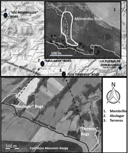
peatlands are located in the area formerly called the "Path of the Bonales" and now the "Path of the Farmed Fields"; a toponym referring to the intense agricultural activity and livestock in the surrounding environment. The “Bonal de Los Terreros” is lodged at the valley bottom of the Valdelobillos stream; its slopes have abundant colluvial deposits transported down watercourses from the agricultural fields of the piedmont plains (rañas). These deposits have dried out at some points, with evidence of an abundant presence of livestock that contributes in a very significant way to their notable deterioration. The “Bonal del Abulagar” is located in an area that is hardly affected by the regressive erosion at the head of the Arroyo de los Cuervos. One of the largest hummocks of the area is located in this “Bonal” with an observation point installed for visitors. The third peatland, among the best conserved of the “Bonales”, although affected by certain anthropic
6
Figure 3. “Bonales” selected for this study.
Samples of detrital sediment (around the perimeter and the interior of the “Bonales”) were taken from both the soil and the waters flowing through the peatland of the three “Bonales”. The moss hummock or “vejiga” of the “Bonal del Abulagar” was manually surveyed from its upper area,
7
Table 1. List of samples collected
Peatland (Bonales)
Samples in the accumulations of peat
Samples collected at geomorphological formations at the edges of
the Terreros and Membrillos peatlands
Water samples
Sample Location Sample Location Sample Location
Lo
s
Ter
reros
T3A Samples taken from the wall
and ceiling respectively of a small slope of
the eroded riverbed. T2 Fine matrix of some detrital mantles.
T1a Headwater streams
T3B T1b Paraje de El
Alcornocal T1c Paraje La
Balsa E l A b ul a ga r ( v ej ig a )
S1 Up to 10 cm from the peak
Moss Hummock
(vejiga)
El Observatorio S2 to 20 cm
S3 to 30 cm S4 to 50 cm S5 to 60 cm S6 to 80 cm S7 1.10-1.20 cm
Lo s Me mb ri llos M1 Samples taken from the hillside along which the peatlands are found, from the
first one (M1) to the last one
(M3)
M4 Historical deposits on slopes at the western edge
of the peatland
M1a Headwater streams
M2 M5 Colluvial
deposits from piedmont
(raña) surface
M1b Downstream M3
2.3. Methods.
a) Water samples:
Water samples from each site were collected in dark glass bottles (rinsed three times immediately before filling), placed on ice, stabilized with sulphuric acid at pH <2, and transported to the laboratory for subsequent analysis. Nitrate, nitrite, ammonia, and phosphate levels were then measured in the water samples that had previously been filtered. Spectrophotometric measurements of ammonium were taken with Nessler’s reagent, nitrates, nitrites, and
phosphates.
Temperature, pH, fluid electrical conductivity, and nitrite were assayed in situ in the water samples. Ultrapure Milli-RO Milli-Q water was used when preparing stock solutions of all reagents. Determination of total metal content was in all cases done with analytical-grade reagents.
b) Sediment samples
8
samples were heated to 450ºC and the inorganic carbon was calcinated at 850ºC to determine the content of organic carbon.
Temperature, pH, electrical conductivity, and nitrite content were measured in all of the samples. Nitrate, ammonium, phosphate, and organic carbon levels, as well as the total metal content were also determined in the laboratory analyses.
One portion of each sample was used in the determination of textural composition and for mineralogical analysis. The results of the sequential extraction procedures in the laboratory analyses were checked against the information in Certified Reference Material BCR-701.
c) Analysis of the historical documentary sources.
Cartographic sources, dating from the late 19th and information in aerial photographs from 1956 up to the present were compared. With regard to written documentation, attention centred on the study of information from national archives (National Historic Archive), provincial archives (Provincial Historic Archive and Provincial Council of Ciudad Real), and the Municipal Archive of Puebla de Don Rodrigo.
In addition to the above investigation, documentary sources (written and cartographical sources) relating to a period between the 16th century (“Relaciones Topográficas de Felipe II”) and the 21st century were consulted, to compile historical records documenting changes to the surrounding area during last centuries.
Moreover, maps from cartographic sources, dating from the late 19th c. and information in aerial photographs from 1956 up to the present were compared. With regard to textual documentation, attention centred on the study of information from national archives (National Historic Archive), provincial archives (Provincial Historic Archive and Provincial Council of Ciudad Real), and the Municipal Archive of Puebla de Don Rodrigo.
d) Instrumentation
Sediment pH was measured with Milli-RO Milli-Q water suspension (sediment +water ratio: 1 + 2.5) by a Metrohm model 309 potentiometer equipped with a pH-combined electrode Metrohm (model 6.0233.100) and a Pt-combined electrode Metrohm (model 6.0425.100). Sediment conductivity was measured with a HANNA HA-8733 conductivimeter.
The Robinson’s pipette method was followed to determine the textural analyses. The mineralogical composition of sediments samples were determined by random powder X-ray diffraction (XRD) on a Siemens D-5000 (Munich, Germany) X-ray diffractometer fitted with a Cu anode. Its operating conditions were set at 30 mA and40 kV, at divergences of 2.0 and 0.6 mm with reception slits, respectively. The sample was scanned in (2θ) 0.041 steps with a 3-s count
9
Organic carbon was determined using the loss-on-ignition method by heating at 450ºC, while inorganic carbon was, as previously mentioned, determined by calcination at 850ºC.
The determination of metals was done with 0.5 g of each sample, treated with 10 ml of aqua regia in PFA digestion vessels and heated in a Perkin-Elmer Anton-Paar microwave oven using the multiwave sample preparation system. Hydrochloric acid stabilization of the samples placed in dark glass bottles was followed by Inductively-coupled Mass Spectrometry (ICP/MS) analysis in a Perkin-Elmer Sciex Elan 6000 mass spectrometer. The following elements were determined: aluminium, calcium, iron, magnesium, manganese, sodium, titanium, silver, boron, barium, beryllium, cerium, cobalt, chrome, caesium, copper, dysprosium, erbium, europium, gallium, gadolinium, holmium, lanthanum, lithium, molybdenum, neodymium, nickel, lead, praseodymium, rubidium, antimony, scandium, samarium, tin, strontium, terbium, thorium, uranium, vanadium, wolfram, zinc, and zirconium.
3. Results and discussion.
The regional metamorphic rocks, the existence of filonian rocks and the cenozoic detrital covers (piedmont and colluvium), generated by the erosion of these outcrops, explains the nature, the diversity and the mineralogical content of most of the elemental concentrations identified in this study.
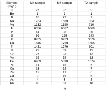
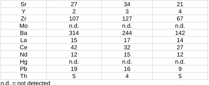
The samples have a similar mineralogy to the outcrops around Puebla de Don Rodrigo. Thus, in the geomorphological units under analysis, there is homogeneity in the presence of elements that are typical of a Paleozoic basement; the most representative are K, Al, Ca, Ti, Mg, and Ba (Table 2).
Table 2. Presence of elements detected in the fine materials linked to geomorphological formations M4, M5 and T2 that border the peatland.
Element (mg/L)
M4 sample M5 sample T2 sample
Li 27 22 9
Be 1 2 1
B 18 22 7
Na 1734 1589 923
Mg 1132 1190 710
Al 6356 6567 6369
P 44 38 36
S 99 125 143
K 8765 9953 3076
Ca 1845 1769 1655
Ti 1421 1276 601
V 29 39 15
Cr 27 33 12
Mn 15 19 12
Fe 6489 5890 1874
Ni 11 15 6
Cu 13 12 7
Zn 12 11 6
Ga 9 16 5
As 4 3 2
10
Sr 27 34 21
Y 2 3 4
Zr 107 127 67
Mo n.d. n.d. n.d.
Ba 314 244 142
La 15 17 14
Ce 42 32 27
Nd 12 15 12
Hg n.d. n.d. n.d.
Pb 19 16 9
Th 5 4 5
n.d. = not detected
Fe is associated with a notable quantity of oxides present in the Paleozoic quartzites of the area. Traces of Fe and Mn were also identified, in fissures and in small concentrations that impregnate the quartzite and the detrital sediments from the cenozoic piedmont [18]. Pb-Zn-Cu associations may be highlighted, linked to their mobilization from seams that run through the Paleozoic structures, some of which have been exploited as mines for centuries. Even in the 19th century, there are references to the presence of a lead and silver mine located between the aforementioned grazing lands and another, exclusively for lead, in the valley of Santa María [19]. All the samples belonging to the “Bonales” revealed a composition of almost 100% organic material (Table 3). It fluctuated between 62% (S2: 20 cm in depth) and 95-99% (S7 and S1), respectively. The sample obtained at a depth of 50 cm (S4) was the only one to present values of below 50%; evidence perhaps of two phases in the formation of this peat layer.
Table 3. Content of organic matter in samples.
Peatland (Bonales)
Sample Organic matter (%)
El Abulagar (vejiga) S1 99
S2 62
S3 67
S4 40
S5 74
S6 90
S7 95
Los Membrillos Samples in the accumulations of peat
M1
95
M2 98
M3 8
Los Membrillos Samples collected at
geomorphological formations M4 3 M5 3 Los Terreros Samples
collected at geomorphological formations T2 34 Los Terreros
Samples in the accumulations of peat
T3A
13
11
A different situation was found at the “Bonal de los Terreros”. Sample T3A, (of a blackish colour)
at first sight similar to organic material, only presented a small amount (13%) and, in addition, the surface sample (T3B) had only 2%. Strangely, the sample taken from the fine matrix of some detrital sediment on the hillside presented the highest values (34%), showing evidence of old peatlands now eroded by a small stream with abundant detrital material.
In the “Bonal del Barranco de los Membrillos”, the peat samples had very few terrigenous materials (<10%), even though those same materials constituted 100% of the surrounding geomorphological formations. Organic material was very high in peat samples M1 (95%) and M2 (98%) and much lower in M3 (8%), further down the hillside, mixed in with the detrital fractions washed down the slope. The minimum values were on the surface formations, M5 and M4 (3%). Texturally, silt (54%-67%) predominated over clays (31%-41%) in all the samples (Table 4). Mineralogically, quartz (70-95%) and phyllosilicates were observed, both containing as much as 90% kaolinite, in some cases.
Table 4. Textural and mineralogical composition of the analysed samples.
Sample Sand
(%) Silt (%) Clay (%) Quartz (%) Phyllosilicates (%) Kaolinite (%) Illite (%) Los Terreros
T2 2 67 31 70 30 57 43
T3A 5 54 41 85 15 71 29
T3B <1 60 40 95 5 90 10
Abulagar
S1 <1 <1 <1 <1 <1 <1 <1
S2 <1 21 79 68 32 76 24
S3 <1 28 72 65 35 70 30
S4 <1 49 51 77 23 99 <1
S5 <1 18 82 70 30 79 21
S6 <1 10 90 <1 <1 <1 <1
S7 <1 10 90 <1 <1 <1 <1
Barranco de los Membrillos
M1 <1 <1 <1 <1 <1 <1 <1
M2 <1 <1 <1 <1 <1 <1 <1
M3 <1 13 87 5 95 55 45
M4 2 44 52 88 12 67 33
M5 4 36 62 99 <1 <1 <1
12
The highest concentration of Pb (22 mg/L) was observed in S1. The presence of Al may be highlighted in the “Bonal de los Terreros” (8126 /12578 mg/L at the deepest levels) with the minimum concentration at a depth of 10 cm (S1) in the “Bonal del Abulagar”.
A single-factor ANOVA statistical test was performed to establish the significant differences in the content of the main elements shared between the samples gathered from two peatlands (“Terreros”, “Abulagar” and “Barranco de los Membrillos”) and their surrounding geomorphological formations.
With regard to the main elements -Ca, Mg, Na, Al, and K- shown in Figure 4, significant differences were observed in the content of Al and K; the samples collected from the geomorphological formations on the edges of the “Terreros”, the “Abulagar” and the “Barranco de los Membrillos”
peatlands had higher values than the samples from within the peatlands. However, there were no significant differences between the groups and the probabilities that the peatland samples would be equal to the samples from the other geomorphological formations were 78%, 73%, and 17% for Na, Mg, and Ca, respectively.
Figure 4. Major content of cations from the samples under study. * Presents significant differences (P>=0.05).
13
a high quantity in the samples at the edges of the peatlands. The probability that the content of the peatland would be equal to the content of Ba, Pb, and S outside the peatlands was 60%, 12%, and 24%, respectively.
Figure 5. Content of Ba, Pb, S and Fe of the samples under study *: Presents significant differences (P>0.05)
The conductivity of the peatlands reflects their changing conditions, passing from oligotrophic to meso-eutrophic. A higher conductivity is related with the increased quantities of dissolved ions in the environment, favoured by the influence of strong anthropic activity detected in the uppermost samples.
The water-chemistry of these peatlands are minerotrophic (Table 5), due to the acidic properties of the basement rocks, showing low pH values (5.17- 5.94), usually under a threshold of 6, exceeded in only one water sample (T3) (6.72). Low conductivities (28.7/30.0 dS/m) are linked to a weak hydrochemical charge. The highest conductivity only reached 129.4 dS/m at one of the peatlands (“Bonal del Abulagar”).
Table 5. Properties measured in peatland waters.
Los Terreros
El Abulagar
Barranco de los Membrillos
T1A T1B T1C M1A M1B
14
Conductivity (dS/m) 72.4 48.5 44.3 129.4 28.7 30.4
pH 5.88 5.94 6.72 5.54 5.17 5.67
Nitrate (mg/L) 7 5 5 6 4 4
Phosfate /mg/L) 10 6 12 15 4 5
Ammonium (mg/L) 0.30 1.22 0.40 2.80 0.80 0.40
Nitrite (mg/L) 0.08 0.10 0.04 0.12 0.03 0.05
These waters incorporated most of the elements detected in the mineral fraction of the different geomorphological formations, with the predominant presence of Ca, K, Mg, Na, Si, and Fe (Figure 6).
Figure 6. Variation of principal elements in the waters.
Al was very well represented in the mineral fraction, but not in the waters (39µg/L -319µg/L). The concentrations of Al in natural waters were quite low (10µg/L) when compared with the established threshold for human consumption at 100µg/L [20].
15
fluctuated around 1/3µg/L; there was a higher presence of both Cd (with values between 4/338µg/L) and Hg (≈ 20µg/L).
A none-too excessively high nutrient content should be underlined, despite the frequent passage of cattle left to graze over some of the peatlands: nitrates fluctuated between 4 and 7mg/L; ammonium between 0.3 and 2.8mg/L; with a tolerable presence of nitrites that never exceeded 0.12mg/L.
There was a higher presence of phosphates (4-15 mg/L), without doubt linked to the spreading of fertilizers on the arable fields bordering the small flat-bottomed valleys that are home to the peatlands. This observation is supported by the very small amounts of phosphate found in one of the peat bogs at the furthest distance from the municipal boundaries and with the least agrarian activity around it (“Bonal de los Membrillos”).
The most notable phosphate concentrations were found in the waters of the “Bonal de los Terreros”, linked to agricultural activity on the nearby cenozoic piedmont. In addition to typical
values in their main components (Na, Mg, Si, K, Ca, Fe) (Figure 6), the minimum concentrations of Hg stand out in sample T1 offering the highest concentration of Hg and Cd. The hydromorphism of this peatland is attributed to waters with the highest conductivity (129.4 dS/m) recorded in the study and the highest quantity of nutrients, in phosphates (15 mg/L), ammonium (2.8 mg/L) and nitrites (0.12 mg/L). Together with their main components Na, Mg, Si, K, Ca, these waters had the highest concentrations of Al (297µg/L), Fe (1864µg/L), Cu (30 µg/L), and Ba (274 µg/L); and, moderate amounts of the heavy metals Hg and Pb (21µg/L and 3µg/L, respectively), although they contributed larger quantities of lead.
The waters flowing down the hill-slope towards the “Bonal del Barranco de los Membrillos” showed the lowest pH (5.17) in their middle segment (“Membrillos 1”); while the pH value of the waters on the foot-slopes (“Membrillos2”) rose to 5.67. In general, the conductivities are very low (≈30 dS/m). The further the peatlands are from the population centres, the less evident the effects
of agricultural land use, with a scarcity of nutrients: nitrates (4.0 mg/L), phosphates (4.0 and 5.0mg/L), and nitrites (0.03 and 0.05mg/L); and a concentration of ammonium that was also low (0.8 and 0.4mg/L) (Fig. 5). Conversely, the amounts of Sc (1369µg/L) and Zn (144µg/L) stood out in one of the samples, in contrast with the trace elements of those metals found in the rest of the waters.
16
bacteria [26]. Cd may also be of atmospheric origin. However, it is more likely that its presence in the waters is due to the spreading of phosphate-based fertilizer containing Cd [20] on adjacent arable lands.
Most of the chemical elements identified in the peatlands and the detrital materials interspersed with the mosses were transported by the action of surface run-off (in either solid or ionic form). They are also the product of a series of biological reactions, due to the actions of anaerobic bacteria.
The elements transported by the geomorphological processes come, in turn, from small streams running down the hill slopes and lateral water flows.
Few authors [27] have applied the notable knowledge now acquired on the mobilization of nutrients. For example, knowledge linked to water flows, and the still limited knowledge of natural processes that are involved in the liberation of different metallic and metalloid components on the hill slopes and their migration and sedimentation at the valley bottoms. Together with the elements contributed by the waters, the presence of S is remarkable. Its appearance, sometimes in notable quantities, has been known for a long time both in current peat bogs [28] and in coal deposits from different geological ages [29]. The biochemical cycle of sulphur is very dynamic in peatlands and its greater or lesser presence is a reflection of the bacterial activity and can only be explained by the anoxic/oxic environmental conditions recorded at each site.
The high-nutrient concentration in the samples that were collected must also be highlighted. Na, Mg, K, Ca, together with Fe were the elements that yielded the highest values. The characteristics of all peatlands are precisely the opposite; very few nutrients for the plants [12]; the presence of carnivorous plants in these habitats due to a scarcity of nutrients in the environment is also well known. It clearly shows the short-lived retention of water in the system, given its large quantity of cations; if the water had remained for longer periods, the vegetation would have taken up the cations, extracting them from the wetlands.
17
Figure 7. The study of the river-banks shows that their fluvial erosion has undermined three very recent geomorphological units: a lower layer of unstratified pebbles and gravels from the slopes, formed by historical colluvium; linked to deforestation carried out until the mid-19th century, its
detrital elements still forming the alluvial gravel beds of the current watercourses. The peat layer, almost 20 cm thick, above the historical colluvium, is found under a very much more recent layer of colluvium (>1950 A.D) in the upper part of this profile, with an identical genesis to
the previous one, linked to intense rarification of the vegetative cover.
The “vejigas” or moss hummocks have thicknesses of organic matter that exceed, at least, one
metre, although clastic sediments are once again common at this depth. Similar features have been described in the Serra do Espinhaço (Brazil) in peatlands located under layers of sedimentation [30], generated from blocks of quartzite in perpendicular positions to the direction of the waterflow.
18
Topográficas of Felipe II” (16th century) of Piedrabuena [31], it states that it has very large and deep peatlands and ponds [and] that at no time dry out ….
Changes in the area were well reflected in the cartography (Figure 8) that clearly defined the watercourses of streams surrounded by natural arboreal and shrubby vegetation at the end of the 19th century; later on, the maps showed irregularities in the streams flanked by fields of crops that sometimes reached the margins of the peatlands. These changes began with intense deforestation in the woodland that covered the slopes and absorbed part of the water contained in the soil. Over time, the water resources, no longer consumed by the vegetation cover that previously occupied the region, eroded the slopes, and caused waterlogging in the valley bottoms.
Figure 8. Summary of the evolution of land use in the area under study (1891 – 2007) Spain topographic maps 1/50.000 IGN.
Over recent years, agricultural activities have expanded widely over the areas occupied by hydrophilic vegetation and are not rare in and around the margins of peatlands. Their surfaces are often disturbed by agricultural actions or host pine, poplar and eucalyptus plantations that dry the soil out.
Given that these plant communities are very dependent on the hydric regime, any alteration (artificial drainage, wetland drying and contamination) implies an impact of enormous significance for vegetal growth. Likewise, all actions directly affecting the vegetation or the soil (extraction of peat, collection of heather, over-grazing, crop rotation) imply notable threats to these types of habitats
19
reeds (Juncus sp.), etc. It was deforestation, the use of intensive grazing and land clearances for cultivation that concentrated the flows and uncovered some communities of plants, previously hidden by pastures.
4. Conclusions.
The analysis of organic matter from the peatlands around Puebla de Don Rodrigo has provided reliable information on their evolution. For example, the highest values of organic matter were found outside the “Bonal de Los Terreros” that suggests the presence of old peatland with abundant detrital material now eroded by a small stream. Moreover, in the moss hummock or “vegija” of the “Bonal del Abulagar”, there is a clear reduction in the content of organic material at
a depth of 50 cm, which may be explained by the phases in the evolution of these accumulations. Whatever the age of the peatlands around Puebla de Don Rodrigo, in view of its geomorphological position on the hillslopes and at the valley bottoms, it would not appear to be very old and could initially be sited in the late Holocene. A thickness of various meters of peat would suggest quite a remote age in the Holocene, but thicknesses of less than 1-2 m would indicate a much more recent chronology
Two very well differentiated stages may be highlighted, separated by antagonistic morphogenetic conditions:
a) before 1950-1955 where more or less degraded vegetation cover dominated the landscape and phyto-stabilized the perimeters of these wetlands. As the fluvial streams shaped the valley bottoms, they promoted processes of regressive erosion in the stream heads, favoured by longitudinal profiles of a certain inclination. This morphogenetic stage would have required an absence of human disturbance or, at most, very weak anthropic activity on the slopes of the area. b) since the mid-20th century up until today, characterized by intense deforestation and the cultivation of extensive surrounding areas. That transformation of the landscape has been the reason for a series of alterations in the geomorphological behaviour of the processes that had up until then been functional: the removal of vegetative cover that mobilized large amounts of colluvium on the slopes. A process of some effectiveness that was favoured by the enormous availability of loose detrital material on the surface of the cenozic piedmont surrounding the peatlands. The transportation of these sediments to the valley bottoms diminished the speed of the water flows, redirecting the fluvial channels and distorting their layout, thereby spreading the waters onto the fields. In addition, these processes decreased the slope of the riverbed profiles, as they were unable to transport the enormous amount of detrital material downstream. The convergence of all of these phenomena favoured the initial waterlogging of the valley bottoms and the first colonization of Sphagnum with a more or less permanent hydromorphy, largely assisted by the impermeable properties of the regional geological outcrops.
20
aforementioned landscape where in addition to the arboreal stratum, extensive grassland areas and anthropozoogenic floristic communities associated with such practices abound. These environmental and anthropic changes are coincident with those detected in other nearby Iberian sequences, as mentioned in the discussion section, although precise chronological dates are not available.
The existence of a current genesis in no way diminishes the importance of these spaces, since the presence of waterlogged sites promotes the development of a specific flora forming a singular site with an important reservoir of humidity and the growth of Atlantic flora in a Mediterranean environment. They are of great value to the landscape and their conservation and protection are of high scientific value.
Author Contributions: Concepción Fidalgo has written the paper, Juan Antonio González has collected the samples, Isabel de Soto has carried out the statistical analysis, Rosario García has analyzed the samples and Carlos Arteaga has made the cartography.
Conflicts of Interest: The authors declare no conflict of interest.
References
1. Rodwell, J.S. British plant. Cambridge University Press, 1998, 552 pp.
2. García Río, R. Una ojeada a los Bonales de Montes Norte (Ciudad Real). Medio Ambiente Castilla-La Mancha,2001, 6, 10-15.
3. Tapia Mansilla, C.F. Crecimiento y productividad del musgo Sphagnum magellanicum Brid en turberas secundarias de la provincia de Llanquihue, Chile. Universidad Austral de Chile, Facultad de Ciencias Agrarias, Escuela de Agronomía, 2008.
4. Korasidis, V.A.; Wallace, M.W.; Wagstaff, B.E.; Holdgate, G.R. Oligo-Miocene peatland ecosystems of the Gippsland Basin and modern analogues. Global Plan. Chang. 2017, 149, 91–104.
5. Martínez Cortizas, A.; Pontevedra, X.; Novoa, J.C.; Rodríguez, R.; López, J.A.; Ferrín, C.; Ferro, C.; Costa, M.; Rodríguez, J. 7150 Depresiones en substratos turbosos del Rhynchosporium. In: VVAA, Bases ecológicas preliminares para la conservación de los tipos de hábitat de interés comunitario en España, Madrid. Ministerio de Medio Ambiente y Medio Rural y Marino, 2009, 28 pp.
6. García Río, R. Flora protegida regional existente en las turberas de Ciudad Real. Conservación Vegetal. Bol. Com. Flora Com. Esp. Unión Mundial Nat.2002, 7, 7-15
21
8. Bragg, O.M.; Tallis, J.H. The sensitivity of peat-covered upland landscapes. Catena,2001, 42, 345–360.
9. De Miguel, E. Conservación y restauración de turbera. Manuales de Desarrollo Sostenible 2, Fundación Santander Central-Hispano, 2006, 57 pp.
10. Vautier, P. Guide de gestion "tourbières des montagnes françaises". Edit Fédération des Conservatoires des Espaces Naturels, 2010, 188 pp
11. Muñoz Fuentes, J.; Brugués, M.; Ruiz, E.; Barrón, A. Claves de campo para Sphagnum de España y Andorra. Bol. Soc. Esp. Briol.1999, 15, 1-8.
12. Molina Martin, A.Diagnóstico y aplicación de medidas de conservación en las poblaciones de Myrica gale en las comarcas de Pinares (Burgos y Soria). Jolube ed., Consultor y Editor Ambiental, Jaca, Spain, 2009, 96 pp.
13. Florín Beltrán, M. Los Bonales de Montes Norte: máquina del tiempo y puerta a otro mundo. In: Gosálvez Rey, RU (ed) Montes Norte Patrimonio natural y divulgación ambiental de un territorio singular, Asociación de Desarrollo Montes Norte, Ciudad Real, 2012, pp.111-131.
14. Dirección General de Montes y Espacios Naturales Consejería de Agricultura Junta de Comunidades de Castilla-La Mancha.Plan de Gestión de Bonales de La Comarca de Los Montes del Guadiana, ES4220019 (Ciudad Real) Documento 1. Fondo Europeo Agrícola de Desarrollo Rural (FEDER), Ministerio de Agricultura, 2015, 45 pp.
http://www.castillalamancha.es/gobierno/agrimedambydesrur/estructura/dgapfyen/rednatura
2000/zecES4220019
15. Martínez Cortizas, A.; Pontevedra Pombal, X.; Novoa Muñoz, J.C.; García Rodeja, E. Turberas de montaña del noroeste de la Península Ibérica. Edafología, 2000, 7 (1), 1-29.
16. Rietveld, H.M. A profile refinement method for nuclear and magnetic structures. J. Appl. Crystallogr.1969, 2, 65–71.
17. Ruan, C.D.; Ward, C.R. Quantitative X-ray powder diffraction analysis of clay minerals in Australian coals using Rietveld methods. Appl. Clay Sci. 2002, 21, 227–240.
18. ITGE. Mapa geológico de España 1/50000, Hoja 757 Puebla de Don Rodrigo. 1999, 81 pp.
19. Miñano, S. Diccionario Geográfico y Estadístico de España y Portugal. 11 vols. (versión digitalizada Biblioteca digital de Castilla y León), 1826-1828.
http://bibliotecadigitaljcyles/i18n/consulta/registrocmd?id=714
20. Baird, C. Química Ambiental. Editorial Reverté, Barcelona, 2001, 621 pp
22
22. Llugany, M.; Tolrà, R.; Poschnrieder, C.; Barceló, J. Hiperacumulación de metales: ¿una ventaja para la planta y para el hombre? Ecosistemas, 2007, 16 (2), 4-9.
23. Prieto Méndez, J.; González Ramírez, C.A.; Román Gutiérrez, A.D.; Prieto García, F. Contaminación y fitotoxicidad en plantas por metales pesados provenientes de suelos y agua. Trop. Subtrop. Agroecosyst. 2009, 10 (1), 29-44.
24. Ruhai, L.; Qichao, W.; Xianguo, L.; Fengman, F.; Wang, Y. Distribution and speciation of mercury in the peat bog of Xiaoxing'an Mountain, northeastern China. Environ. Pol. 2003, 124 (1), 39-46.
25. Allan, M.; Le Roux, G.; Sonke, J.E.; Piotrowska, N.; Streel, M.; Fagel, N. Reconstructing historical atmospheric mercury deposition in Western Europe using: Misten peat bog cores. Belgium. Sci. Total Envir.2013, 442 (2), 290-301.
26. Coufalik, P.; Zvěřina, O.; Komárek, J. Atmospheric mercury deposited in a peat bog, the Jeseníky Mountains, Czech Republic. J. Geoch. Expl. 2013, 132, 120-124.
27. Miller, J.R.; Orbock Miller, S.M. Contaminated Rivers: A Geomorphological-Geochemical Approach to Site Assessment and Remediation. Springer, Dordrecht, 2007, 418 pp.
28. Casagrande, D.J. Sulfur in peat and coal. Presentation to the Geological Society of London, April 1986. In: Scott, AC (ed), Coal and Coal-bearing Strata: recent advances. Geol. Soc. Spec. Publ.1987, 32, 87-105.
29. Querol, X.; Chinchón, J.S.; López, A. Distribución del azufre en los carbones albenses de la cuenca del Maestrazgo. Act. Geol. Hisp.1989, 24, 21-32.
30. Da Rocha Campos, J.R.; Christófaro Silva, A.; Slater, L.; Nanni, M.R.; Vidal-Torrado, P. Stratigraphic control and chronology of peat bog deposition in the Serra de Espinahaço Meridional, Brazil. Catena, 2016, 13, 167-173.
31. Campos, J.; Fernández de Sevilla, F. Los pueblos de Ciudad Real en las Relaciones Topográficas de Felipe II. Imprenta provincial de Ciudad Real, 2009.
Captions of Figures and Tables
Figure 1. Map showing the area of the Iberian Peninsula and the location of the sites that are under study.
Figure 2. A) Water flowing over peatland during the winter months. B) Water flows in winter spilling over the peatland surface. C) and D) Peat swelling.
Figure 3. “Bonales” selected for this study.
23
Figure 5. Content of Ba, Pb, S and Fe of the samples under study *: Presents significant differences (P>0.05)
Figure 6. Variation of principal elements in the waters.
Figure 7. The study of the river-banks shows that their fluvial erosion has undermined three very recent geomorphological units: a lower layer of unstratified pebbles and gravels from the slopes, formed by historical colluvium; linked to deforestation carried out until the mid-19th century, its detrital elements still forming the alluvial gravel beds of the current watercourses. The peat layer, almost 20 cm thick, above the historical colluvium, is found under a very much more recent layer of colluvium (>1950 A.D) in the upper part of this profile, with an identical genesis to the previous one, linked to intense rarification of the vegetative cover.
Figure 8. Summary of the evolution of land use in the area under study (1891 – 2007) Spain topographic maps 1/50.000 IGN.
Table 1. List of samples collected.
Table 2. Presence of elements detected in the fine materials linked to geomorphological formations M4, M5 and T2 that border the peatland.
Table 3 Content of organic matter in samples.
Table 4 Textural and mineralogical composition of the samples