(PLATES 33-48)
E XCAVATIONS by the American School of Classical Studies in the southwest corner of the Agora of Corinth were continued in 1960 for a period of eight weeks, from April 4 to May 28. Supplementary work was undertaken in a field north- west of our excavation dump (April 19 to May 17), in a necropolis on the north slope of Acrocorinth (June 6 to 10) and in the vicinity of the " Baths of Aphrodite " (August 1 to 13 and September 5 to 9).' We also initiated conservation work in the South Stoa and made records of digging done by others in wells on the property of Ioannis Sophos, east of the village, and on the west edge of our old excavation dump (Fig. 1, A), which is now occupied by the pavilion of the Greek National Tourist Organization.
THE BYZANTINE SETTLEMENT
Our campaign of 1959 in the southwest corner of the Agora 2 had cleared approxi-
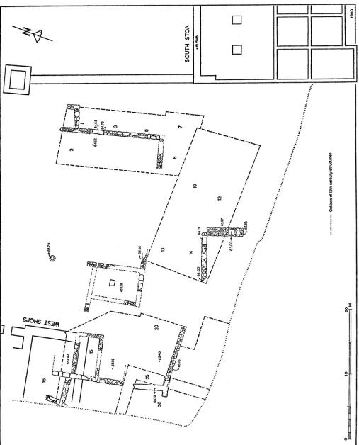
mately one half of the area available for excavation to the level of the 12th century after Christ and had exposed a north-south road, parallel to the west end of the South Stoa and to the line of the archaic Doric columns which supported a Roman aqueduct. Facing on this road we had found a group of four two-room apartments (Fig. 2, rooms 1-8) which- opened onto a common court at the west; south of this complex had appeared the eastern portion of a large building with very deep foundations, its rubble masonry characterized by piers of limestone set at intervals of about 2.00 m. (P1. 33, a). In 1960 we were able to complete the excavation of this southwestern area;
1 It is a pleasure to express the School's gratitude to Mr. I. Papadimitriou, General Director
of Antiquities and Restoration of the Greek state, and Mr. N. Verdelis, Ephor of Argolidocorinthia, for their encouragement and support; and to Brown University for its continued generous financial assistance. H. S. Robinson acted as Field Director. The staff consisted of: T. Leslie Shear, White Fellow of the School; Theodora Stillwell; Ronald Stroud, Seymour Fellow of the School. Steven Dyson, Fulbright Scholar (Brown University) at Oxford, joined the staff for two weeks in spring vacation. Rebecca Wood Robinson assisted the Field Director in the work at the " Baths of Aphrodite." John Travlos has drawn the plans; Figure 1 was prepared by William B. Dinsmoor Jr.; Piet de Jong prepared the drawing for P1. 46, a. Most of the photographs are the work of Miss Alison Frantz and Miss Lucretia Farr. Our foreman was Evangelos Lekkas; the workmen numbered about 36 up to May 28; in June, August and September we employed an average of eight men. As last year, our excavation dirt was trucked to a ravine lying ca. 650 m. southwest of the Odeion (Fig. 1, E); the President of the community of Old Corinth has kindly given us permission to fill this ravine with our dump.
2 Hesperia, XXIX, 1960, pp. 225-235 and especially fig. 2.
Hesperia, XXXI, 2
American School of Classical Studies at Athens is collaborating with JSTOR to digitize, preserve, and extend access to
Hesperia
WV.bD..JQ 1962
0 100 200 300 400 50 600 70 800
FIG. 1. Corinth. Topographical Survey of the North Central Area, Based on Survey Made in 1928 for Greek Ministry of Communications.
A. Old Excavation Dump, 1899-1938 D. Asklepieion Excavation Dump, 1929-1933 G. Well and Graves Dug in 1960 (see pp. 116-117)
B. Theater Excavation Dump, 1925-1929 E. Current Excavation Dump, 1959- H. Fourth Century Chamber Tomb on Cheliotomylos Hill
C. Odeion Excavation Dump, 1927-1928 F. Grave Dug in 1960 (see note 81) (see p. 133)
Fountains and Water Sources (ancient names in italics; no names, ancient or modern, are recorded for nos. 11, 12, 14, 16, and 17 of the survey)
1. Peirene 3. Glauke 5. Tsibouri 7. Deke 9. Kakavi 13. Lerna (Kriebardi)
7149
SI~~~~~~~~~~
I$ ! 81 1 5 21 20
t H 16 t1 1 1- [} t1 1l 1l l~~~~~~~~~SOTH TO
83
82,71~~~~~~~~~~~*
FIG.2.Corinth. yzantneSttlemntio of Cntrl A a (. P
26 20( 6216 i3 ? 1
24 V28s e4 4 L
*t~~~~~~~~~~~~~~~~~~~~~~~~~~~~~OT
S'eH
22- _ >t @ - # Wg 2
-> > " j1 { X - 2W Q"""
23~~~~~~~-s t 8.,11 87
11 11J
| O _ = 2_ r 2P~~~~~~~~~~-F M ._
we exposed the western part of the large building, the entire court and a group of smaller structures which bordered the court on the west (Fig. 2).
The large building (Fig. 3) proves now to be a long, narrow structure, oriented east-west. It is divided longitudinally by one wall, which is not precisely on the axis of the building; at the western end, a north-south interior wall marks off two roughly square rooms.' In the 1959 excavations we had found no trace of a floor and had not with certainty identified foundation trenches for the walls. This year we have found in room 14 clear indication of foundation trenches and of at least a " terminus super
11 12 13 14 15
584.29 8320?
O
13
i 21 10 16xx st o6~4.56 ALi
LARGE POROS BLOCKS LAID HORIZONTALLY 0
2 10
VERTICAL PIERS OF POROS
FIG. 3. Large Twelfth Century Building (Rooms 10, 12-14). Plan
quem" for the Byzantine floor level. At 83.73 m. above sea level'~ in the north part of room 14 appeared a floor of hard, pinkish cement, ca. 0.05 m. thick, resting upon about 0.12 im of rubble concrete (Figs. 2, 4)., Along the east, south and west sides of the room the cement was cut away by trenches which had origi'nally been 1.70 m. to 2.00 m. wide at top and 1.85 m. deep, dug through the cement and concrete and t he
8 Exterior dimensions: L. 23.00 m. on south, 22.00 m. on north wall; W. 10.22 m. on east,
10.11 m. on west wall. None of the rooms of the building is perfectly square; all show considerable variations in their interior dimensions. The north wall of room 10 is 16.08 m. long, the south wall of room 12, 17.08 m. Room 13 measures approximately 3.82 m. (N-S) by 3.75 m. (E-W) - room 14, 4.25 m. (N-S) by 3.75 m. (E-W).
underlying earth fill (P1. 33, a). In these trenches had been laid the foundations of the big building, 0.70 m. thick.5 The foundations of the north wall of room 14 were not continuous; at the center was a gap 1.95 m. wide. For this reason the cement floor was not cut away at the north by a foundation trench. In fact, one can still observe a slight up-turn (cove) of the cement along its north edge, indicating that the north wall associated with the cement floor coincided with the line of the north wall of the Byzantine room 14. Unfortunately, no other edge of the cement could be found, nor has any trace of the floor appeared beyond the limits of room 14; its
8458 84.56
S Ba) , < _ S 83.93 ~~~~~~~~~~~~~~~83 52 I
NOT EXCAVATED
O 5
FIG. 4. Large Twelfth Century Building (Rooms 10, 12-14), West End. Section (a-a), looking North
original dimensions must remain unknown. However, the cement slopes (0.18m. in 1.30 m.) from its north edge southward to the rim of a shallow, oval collecting basin 6 (Fig. 4; Pl. 33, a); from this basin the concrete slopes upward also to east,
south and west. If we assume that the basin marked the center of the cement floor, we may restore the original north-south dimension of the floor as 3.15 m. The cement floor may be dated in the 4th or 5th century after Christ by fragments of coarse pottery found in its rubble-concrete base and by pottery and one coin from the fill
5 The outer face of the trenches appears to have been cut vertically; the stones of the wall
construction were laid flush against the vertical scarp. Consequently no foundation trench was apparent outside the walls.
lying immediately beneath.' The pottery from the foundation trenches for the east, south and west walls of room 14 is predominantly Roman (1st century to 5th),8 but includes some fragments of Byzantine wares of the 2nd quarter of the 12th century.) To this later period we should assign the construction of the big building (rooms 10, 12-14). The floor level of the building must have been higher than the late Roman cement floor (at 83.73 m.) and also higher than the preserved top (at 83.93 m.) of a north-south wall (Figs. 2, 4) at the west end of room 10. This wall is built of rubble with mortar; its niorth and south ends have been cut away by the foundation trenches dug for the north and south walls of room 10 (Fig. 2). The wall (83.93 mn.)
must antedate the construction of the big building and must have been covered by the floor of the latter structure.
It is regrettable that the walls of the big building are at so few points preserved to a height above that of the original floor (cf. Fig. 3). It is at the west end of the south wall that the greatest height is preserved, and here we have a threshold in situ (at 84.39 m.) ; the lowest stone of the east jamb is also in position. The cuttings for the pivot holes in the threshold and the rabbet of the jamb are clearly visible (Fig. 3; P1. 33, b). At the west end of the threshold the jamb is not preserved, but it is obvious that the door was of two leaves and opened inward; its width, from center to center of the pivots, was 1.90 m. A second set of holes indicates a remodelling in the course of which the opening was narrowed to 1.50 m. The threshold consisted of two separate courses of limestone: the lower (0.70 m. wide) contains the pivot holes; the upper (only 0.34 m. wide) was the door stop (0.20 m. high). Only a small piece of the stop is preserved at the eastern end of the threshold. The foundations for the wall are continuous under the threshold (P1. 33, b). At three points, however,-in the north walls of rooms 13, 14 and 10-the foundations are not continuous; the unsubstantial rubble construction which fills these gaps at a high level may indicate underpinning for other thresholds (Fig. 2) .2 The barrier across the opening in the median wall
7LOT 505. Since 1959 the lots of pottery retained for study and for chronological control have been assigned serial numbers whose use, it is hoped, will facilitate storage, reference and future re-examination. The single coin found here was a bronze of the House of Constantine.
8 The earth which was excavated from the trenches by the Byzantine builders represented, from
the level of the cement floor down, periods of Roman occupation; it was primarily this fill, of course, which was utilized for filling the sides of the trenches after the construction of the wall foundations.
9 LOT 504. Along with earlier Roman coins from this fill appeared one Byzantine Anonlymous
Bronze, Class A-1, 969-989 after Christ.
10 For further evidence which may have a bearing on the date of construction, see below,
p. 107.
11 Mortar was not used in the walls of secular buildings of the 12th century at Corinth.
12 An early Roman drain, which was cut through by the foundations of the south wall of room
14, passes under the openings in the north walls of rooms 14 and 13 (below, p. 112). This
of the structure is an obvious addition or after-thought, for it is 0.20 m. less thick than the rest of the wall (Fig. 2; P1. 33, a). At other points where the foundations are missing wholly or in part (as at the northeast corner of the building and in the south wall of room 12 between piers 3 and 4) the condition is due to pillaging of the walls for building material in the 13th century.
The upper level (doorstop) of the threshold in the south wall of room 14 (at 84.59 im.) lies 0.66 m. above the " terminus super quem" of the floor and 1.20 m. above the outside ground level (at 83.39 m.), which is indicated both by a hard-packed earth surface on the exterior (P1. 33, a, in right foreground; also Fig. 2)13 and by the obvious change in wall construction at this level. Above the outside ground level the rubble masonry consists of roughly squared blocks with brick or tile fragments in the horizontal and vertical joints; below ground level the stones of the rubble work are less carefully dressed and there is no regular placement of tile fragments in the joints (P1. 33, a-b). Piers are employed, however, at intervals in the foundations as well as in the superstructure; 14 it is clear, therefore, that the foundations were care-
fully laid by workmen operating in the wide foundation trench. Others of our Byzan- tine walls appear to be constructed on foundations of roughly coursed, loose rubble which could have been poured into a very narrow foundation trench (as P1. 34, a, center and right).
The foundations of the big building are of considerable depth. Only at two points have we exposed them to bottom. Trenches dug inside and outside the south wall at its west end revealed the foundations resting upon hardpan 15 at 80.73 m., or 2.66 m.
below the ground level outside the structure. In the northwest corner of room 13 the base of the foundation lies at 80.33 m. The walls of the building, both in foundation
nor did they plan to utilize the drain cover slabs as support for the superstructure of the walls over these two openings, for deposits of earth fill as much as 1.10 m. deep lie between the drain cover slabs and the later walls which were built across the openings. (In the photograph P1. 33, c the earth fill at top is that which lies directly under the line of the north wall of room 13.) The tops of the cover slabs of the drain lay at: 82.83 m. south of room 14; 82.61 m. under the median wall of the building; 82.48 m. under the north wall.
13 This surface was exposed from the southwest corner of the building eastward for a distance
of about 7.00 m.; part of it has been cut away, as shown in P1. 33, a-b, by a test trench dug to expose the base of the foundations of the big building at the southwest corner. The blocks of masonry which project from the south face of the wall just under the east and west extremities of the threshold probably served as partial support for the short flight of (wooden ?) steps which must have led from the outside ground level up to the doorway.
14 The piers were generally laid in two or more vertical tiers, with horizontal slabs between.
The cross-slabs over the lowest pier are in place at positions 1, 4, 5, 9, 11, 12, 13, 14, 15, 17, 19 (see Fig. 3); at positions 7, 8 and 21 the pier of the second tier is still in situ.
15 At the extreme southwest corner the foundations were laid upon the remains of an older
north-south wall, probably of Greek times (Fig. 4, 81.86 m.; P1. 33, b). The north wall of room 10,
and in superstructure, have a uniform thickness of 0.70 m.; they are appreciably thicker than those of the other Byzantine buildings in the southwest area, which are generally 0.50-0.60 m. thick.
The depth of the foundations of the big building, the thickness of its walls, and the style of its construction (more commonly found in religious structures) suggest that this building was of at least two stories. It is clear from the plan that it was a secular building, the largest in Byzantine Corinth; but its precise function is by no means clear. It has been sugested 16 that we have here a private house such as in later
times would have been called an "archontiko spiti " and that the internal divisions visible on the plan represent ground-floor storerooms and stables. It is not impossible that the structure was of industrial character. Perhaps it served some function in connection with the raising of silkworms and the weaving of silk, an industry which most probably flourished at Corinth in the 12th century.'7 Unfortunately, the building was destroyed so thoroughly that the original floor levels disappeared entirely. No artifacts were found which could be associated with the use of the building and which might have suggested its function. The life of the building was short, for its destruction must fall around the middle or in the 3rd quarter of the 12th century."8
16 By Mr. D. Pallas, Ephor of Byzantine Antiquities.
17 Niketas Choniates (Hist. Man. Comn., II, pp. 99-102, 129-130 [Bonn ed., Corpus Script.
Hist. Byz.]) describes the sack of Corinth by Roger of Sicily in 1147 and the subsequent fate in Sicily of those Theban and Corinthian captives who were skilled at the loom; his reference to their production in Sicily of cloth shot with gold makes it reasonable to suppose that the particular skill of these craftsmen was in weaving silk. We may assume that Corinth prior to 1147 had a considerable number of skilled silk-weavers (see also A. Bon, Le Peloponn'se byzantin jusqu' en 1204, Paris, 1951, pp. 128-131). For a Corinthian epitaph of a Jewish (silk- ?) dyer, dated between the late 9th and the 12th centuries, see J. Starr, Byz.-Neugriech. Jahrb., XII, 1935-1936, pp. 42-49.
18 Sherds found in a pillaging trench near the west end of the south wall of room 12 and just
below a late wall built across rooms 12 and 14 (Fig. 6) belong to the second half of the 12th century (LOTS 240, 253, 257, 502); one early bronze coin of Manuel I (Type 7, see note 26) was found below the later wall. The west end of the large structure was in ruins in the last quarter of the 12th century, when a stream of water washed across room 13 from southwest toward northeast and deposited a deep layer of gravel; this fill contained many coins of Manuel I and one of Isaac II
We hope that it may be possible to rebuild the walls of this impressive structure to a point slightly above its contemporary ground level and to keep it exposed, even after the surrounding (and less well-constructed) buildings have been removed to permit our investigation of the underlying Roman remains.
The court which was partly exposed in 1959 to the west of the bronze-working establishments (rooms 1-8) has now been cleared over its full width from east to west (Fig. 2). The court is narrow at the south, where there may have been an entrance, and much wider at the north, where there was an exit from the northwest corner. In late Roman times (4th century)'9 the ground level of this area sloped off from ca. 83.50 m. at the south to ca. 82.95 m. at the north. In the later 12th century great masses of fill were introduced to raise the level and to create a court which sloped down slightly from south to north and from west to east. It has been impossible to find any consistent pavement of the court or to determine precisely its configuration. At the south its level was about 84.10 m.; at the east the court floor must have been close to the level of the threshold in the west wall of room 4 (83.41 m.);
at the northwest it was approximately 83.76 m. (threshold of area 15, see below, p. 104). To the north the surface was certainly below 83.79 m., at which level we found the cover slabs of a well which was in use into the late 12th century (Fig. 2).2?
This well is in reality a manhole of the Peirene system and is connected by a tunnel with the manhole founld in 1959 under the west wall of room 6; 21 another tunnel
leads north from the manhole in the court.2" The well must have served as a com-
Corinth can antedate 1147 and how much must be later than that date (see J. Harris, Hesperia, X, 1941, p. 161), but the researches of Mr. D. M. Metcalf (see note 26) give hope that this distinction may soon be possible.
19 LOTS 456-458, 494.
20 The court floor here may have been at ca. 83.15 m., the level at which were found two marble
blocks, each a crowning member from a statue base. These had been set into the earth on a line extending eastward from the well and spaced at intervals of about one meter. It is highly probable that they served as stepping stones leading up to the wellhead. The eastern of these two blocks bears an inscription (below, p. 116).
2'Hesperia, XXIX, 1960, p. 231.
22 The softness of the clay walls and roof of the tunnels made it impossible to dig for any
appreciable distance in either branch. It appears that the tunnels were blocked in Roman times; but the manhole (its mouth built up as the surrounding ground level was raised) remained in use as a well. From its top (at 83.79 m.) to 82.73 m. the shaft is built of masonry without mortar; this rests upon a circular drum cut from a single block of poros (inside diameter 0.55 m.), below
which masonry construction reappears (82.28 m. to 81.07 m.); there follows another circular
munal water supply for all the buildings around the court, none of which had private wells or cisterns.
The structures which lay on the west side of the court presented at the time of excavation a most chaotic plan, the result of extensive rebuilding and overbuilding. Figure 2 gives a simplified picture, from which have been omitted all later and earlier walls which cannot, or do not yet, reveal any coherent elements of plan.23 All of the Byzantine buildings here are of rubble construction, without mortar; none shows the careful workmanship or the patterned arrangement of brick and tile fragments which we have noted in the big building to the east (rooms 10, 12-14). The most interesting structure is that at the north, rooms 15 and 17-19. Here we have a trapezoidal area (15; P1. 34, b) entered from the court by a doorway 1.26 m. wide; the door consisted of a single leaf, pivoted at the north side and swinging inward; the poros threshold (at 83.76 m.) and the lowest stone of each jamb are in situ. Area 15 may have been a stable yard, the small room 17 a stable (large enough for a donkey and a few goats). An ell-shaped room (18) and a small rectangular one (19) com- prised the living quarters. It is not apparent that room 16 connected with either 15 or 17. No significant household artifacts were discovered here; nor did we find in this complex or in the other rooms further south any traces of industrial activity such as were recovered in 1959 in the bronze-working establishments, rooms 1-8.24 We must imagine that all the structures west of the court were purely residential in character. Little can be made of rooms 20-26, which occupy an area much built over in Frankish times. The plan in Figure 2 shows those walls which seem most clearly to belong to the 12th century. The area is divided by what must have been an alley (25), only 1.60 m. wide, extending from south to north between rooms 24 and 26 and at the north making a bend to the west. Room 20 was entered from the 12th century court by a door in the east wall; the clay threshold lay at 84.15 m. Under the south wall of room 21 was found a terracotta pithos, its mouth at 83.75 m. This contained pottery of the 10th and possibly of the 11th century; 25 it was covered in
the 12th century rebuilding of the area. We may assume a change in level of about 0.40 m. in the course of the century or more which separated the period of the pithos from that of rooms 20 and 21.
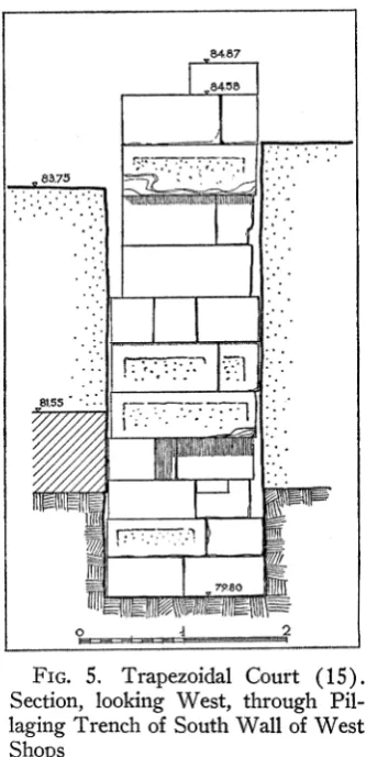
The south wall of the stable (17) is thicker than the others of this complex, for it is built upon the remains of an earlier wall constructed of heavy, well-squared blocks of limestone (Fig. 5; Pls. 34, b, 35, a, d). The preserved top of the earlier masonry is at 84.58 m.; above this level and toward the west end of the wall appears
23 In Figure 2 walls whose masonry is indicated by cross-hatching are Roman or earlier; those
in which the individual stones are outlined are late 12th century or early Frankish. The Greek South Stoa and the West Shops are indicated schematically in outline.
24 Hesperia, XXIX, 1960, pp. 230-231.
Byzantine construction, primarily re-used material, extending up to 85.15 m. A trial trench cut through the trapezoidal court revealed that the earth floor of the court (at ca. 83.75 m.) had formed after the filling of a trench which extended eastward the line of the south wall of the stable (17). We excavated this trench to bottom on hardpan at 79.80 m. (Figs. 2, 5; P1. 35, a). The filling can be dated by potsherds in the 2nd quarter or the middle of the 12th century and appears to be uniform from top to bottom of the cut.26 Clearly we have here a pillaging trench; from it were
. ..87
~84!58
. 2
FIG. 5. Trapezoidal Court (15 Section, looking West, through Pil- laging Trench of South Wall of West Shops
*844O
2
0, s
-* ... .. I...1
15
.
* X6 . 7
44. 4 .
807 12~~~~
4 I~~~~~~~~~~~~~~~~~~~~_
removed in the middle of the twelfth century dressed blocks of limestone which con- stituted the eastward continuation of the older wall on which the stable wall was built. The older construction was the south wall of the West Shops (Fig. 2). We must assume that at the time of the pillaging, the area represented by the stable (17) and room 18 was already built over; that is, the western half of the south wall of the West Shops was then in use as part of a building and hence its upper courses could not be sacrificed. The need for building material, however, was so great that in the area of the court (15) blocks were laboriously removed from the eastern half of the older wall to a depth of as much as four meters, to the very base of the construction. Elaborate machinery must have been required for the removal of the stones; equally elaborate machinery must have been needed for the erection of the limestone piers of the big building (rooms 10, 12-14) to the southeast. Measurement of the blocks in the exposed courses of the West Shops wall and of the piers in the big building reveals that these two groups of stones correspond rather closely in size.27 It is a reasonable assumption that the pillaging of the West Shops wall was undertaken in order to supply the piers needed for the construction of the big building. We thus find in the filling of the pillaging trench confirmation of the date already suggested (above, pp. 100, 102) for the building of the latter structure, the 2nd quarter or middle of the
12th century.
In addition to the buildings of the 12th century already described, we have found in the 1960 campaign some walls which appear to be of the Frankish period or later (Fig. 6). In most cases these late walls are preserved only as frusta disjecta which defy attempts at reconstruction of plan. Two late walls, almost meeting at right angles over rooms 12 and 14, present certain peculiarities. One, built on a north-south line, is of rubble construction without mortar, 1.25 m. wide; near its south end appears a square cavity which the builders purposely left in the wall.28 We cannot determine whether the cavity rose to a greater height in the original fabric of the wall; we do not know how it was covered nor how one had access to it. At the time of excavation the cavity was filled with earth containing a large quantity of simple Proto-Majolica ware which should be dated in the 13th century.29 The second wall (see above, note 18) was 0.83 m. wide at its east end and of rubble construction which contained, however, some roughly dressed blocks of large size. The unusual feature of this wall is that its foundations slope up from east to west, the angle of inclination
27 Most of the exposed courses of the West Shops wall are 0.445 m. or 0.485 m. high (Fig. 5);
those blocks which are laid as headers (and whose length can thus be measured across the section of the wall) vary from 0.88 m. to 1.385 m. in length. The piers of the big building (as they now stand in the walls) show the following range of dimensions: W. (measured along the face of the wall) 0.44 m. to 0.45 m. (with a few exceptions up to 0.53 m. and down to 0.39 m.); H. 0.90 m. to 1.49 m.
28 Dimensions: 0.70 m. x 1.16 m.; at least 0.90 m. deep. Bottom of the cavity is at 83.00 m.
being determined, apparently, by the preserved tops of the walls of the big building over which it passed.80
Room 26 and the smaller rectangle within the area of room 24 (Fig. 2) are apparently slightly later in date than the complex which lies to the north and east. No distinct floor levels were observed. The fill within the area, near the preserved tops of the walls, is presumably to be associated with the destruction of the building; it con- tained pottery and coins of the late 13th century.8' Over the east wall of room 26 and across the corridor (25) was constructed a later wall of which only a tee-shaped fragment remains (Fig. 6). The cross-bar of this " tee " (at the south) was in turn built over by a wall which rested on the remains of the late 12th century or early Frankish wall in the area of room 24 and extended its line westward across the adjacent corridor; the construction of this wall suggests a floor level at about 85.40 m.
(P1. 34, a), but no floor surface was preserved.
Some walls, associated with floors of clay at 85.06 m. and 84.90 m., appeared over the area of rooms 15 and 17-19 (Fig. 6); the pottery found below the floors belongs to the middle of the 13th century.82 The structure is contemporary with a long wall found in the 1959 campaign, built above the ruins of rooms 1, 3, 5, and 8 (Fig. 6). A threshold in this wall (located over the party wall of the earlier rooms 1 and 3) lay at 84.63 m.; at the same level, both to east and west of the wall, appeared a clay floor, immediately below which was a layer of pebbles (bedding for the clay or earlier floor?). The fill below the clay floor here also belongs to the middle of the 13th century 88 and indicates a period of occupation of the structure in the 2nd half
of the century. It is not possible to develop any coherent plan from these late walls. A few wall fragments over the western part of the 12th century court, associated with a floor level at 84.18 mi., can be restored as a room measuring 4.60 m. x 6.70 m.
Pottery found beneath the floor is of the 13th century.84
30 At the west end the foundations rested directly on the southwest corner of room 14, at
84.35 m.; at its east end the base of the wall lay at 83.72 m. The maximum preserved height of the wall was 0.50 m. The wall has been removed to facilitate our investigation of room 14 and does not appear in the photographs, P1. 33, a and b. No floor levels were found in association with this wall or with the other mentioned above. The block which formed the east termination of the east-west wall measured 1.30 m. x 0.83 m. x 0.44 m.; it is probably one of the blocks of the south wall of the West Shops, re-used in the 12th century as a pier of the big building and then soon again re-used here over the ruins of the latter structure.
31 LOT 397. Two coins of William Villehardouin (1250-1278) and one of Philip of Tarentum
(1294-1331).
32 LOTS 430, 440. Among the 23 identifiable coins from these fills are: four of William
Villehardouin, Corinth issue (1245-1250); one of Louis IX of France (1226-1270).
83 LOTS 282, 283, 286. Of 82 bronze coins, 32 were identifiable; the latest were: William
Villehardouin, Corinth issue, 1245-1250 (9); Alexius III, 1195-1203 (1); Isaac II, 1185-1195
(1); Manuel I, 1143-1180 (12).
34 LOT 424. Of 13 coins 10 could be identified. The latest of these are: William Villehardouin,
Some traces of construction of Roman date appeared in the 1959 campaign.3" More was discovered in 1960. This year we dug deeper in the road gravel which runs along the east edge of the area in order to reach the Roman levels of that thoroughfare. A cut was made through the road just east of rooms 9 and 11 (Fig. 2). The highest level of road metal exposed last year (84.02 m.) belonged to the first half of the 13th century; 86 the level associated with the thresholds of rooms 1, 3, 5, 7, 9, and 11
(at 83.52 m. to 83.00 m.) is of the second half of the 12th century."7 Below that level lay a further accumulation of gravel which revealed no real stratification (in spite of erratic changes from gravel to sand in pockets and irregular layers). At 82.23 m. to 81.87 m. we found a series of limestone paving slabs (Fig. 2; P1. 35, b) similar to those of the Lechaion and Kenchreai Roads."8 These slabs were apparently in situ; the gravel immediately above them contained pottery and coins which could be dated in the 6th century after Christ."9 At one point, where the paving slabs were missing, probably as the result of Byzantine pillaging, we dug to greater depth, finding that gravel fill extended below the level of the paving." This fill contained pottery which was predominantly early Roman, of the middle of the 1st century after Christ.4' It seems highly probable that the paving slabs were first laid in the middle of the 1st century and that their original level is indicated by a mortar bedding of which traces were noted at 81.98 m., at a point opposite the party wall of rooms 9 and 11. This level is approximately one meter higher than that of the road which ran past the west end of the South Stoa when that building was constructed in the 4th century B.C. The
evidence of pottery and coins suggests further that the paving slabs were raised about 0.25 m. during the 5th century (to the level at which we found them) and that by the 2nd half of the 6th century the road paving had been abandoned and gravel had been
35 Hesperia, XXIX, 1960, pp. 231-233.
86 LOTS 307, 308, 313-315.
37 LOTS 321, 323.
38 Lechaion Road: Corinth, I, i, pp. 136-141, 190. Kenchreai Road: Corinth, I, iv, pp. 128-129.
The construction of both roads is placed in the early 1st century after Christ.
39 LOT 849. Of 144 coins recovered, 96 could be identified. Three Byzantine coins of the 10th
and 11th centuries were probably, as a few Byzantine potsherds, intrusions resulting from Byzantine pillaging for paving blocks. Of the remaining coins, 38 were of the 5th and 6th centuries, the latest being: Justin II, 565-578 (1); Justinian I, 527-565 (1) ; Anastasius I, 491-518 (3). The pottery was almost all coarse, of 5th and 6th century types.
4 It is clear that gravel extends also underneath the blocks of pavement which are still in place.
We have not yet lifted any of these blocks to test the (uncontaminated?) fill beneath.
41 LOT 848. Of 115 coins recovered, 74 could be identified. The latest were: Leo I, 457-474
laid (or allowed to accumulate) over the limestone slabs. It is worth noting that in 1959 we found similar slabs within the area of room 5, at 82.28 m., well below the floor level of that room, which lay at ca. 83.40 m. (Fig. 2).42 It is not impossible that the Roman road branched west at a point opposite the southernmost column of the Roman aqueduct supports and that the slabs in the area of room 5 represent the paving of the branch road.
Other Roman and Greek remains have been exposed at various points as a result of soundings. Walls of earlier date are indicated by hatched masonry on the plan, Figure 2. Those under and west of rooms 6 and 8, which probably have extensions beneath rooms 5 and 7, were noted in last years's report.43 Between the big 12th century building and rooms 20, 22 and 23, below the southern part of the court, have appeared several walls, for the most part of unsubstantial rubble masonry (Fig. 2). In association with them at the southwest corner is a small, shallow basin (0.80 m. x 0.75 m. and 0.22 m. deep), lined with thin slabs of marble; the floor of the basin lies at 83.33 m. Just to the north of this basin are traces of a second, its floor 0.15 m. lower; the two basins are separated by a wall of brick and mortar 0.26 m. thick. The marble used for the lining of the basins is of various types: white, reddish, gray, white veined with gray. To the east of the basins, and at a level slightly below that of their floors, are preserved sections of a terracotta water pipe which can be traced for at least 3.00 m. toward the northeast; beyond that point it disappears in fill which has not been excavated. The interpretation of this late Roman structure is not yet clear. Adjacent to the outer face of its north wall was a late Roman grave (Fig. 2), its lid supported on the south in a slot cut into the wall. The north wall of the grave was constructed of roughly dressed blocks of limestone set without mortar; the ends were not built up. The floor was of earth (at ca. 82.26 m.); the lid consisted of large slabs of limestone laid across the grave from north to south (P1. 35, c)." The burial was oriented east-west; the heads of the skeletons were toward the west.45 Like
42 Hesperia, XXIX, 1960, p. 232.
43 Hesperia, XXIX, 1960, p. 231.
44 Interior dimensions of the grave: L. 1.85 m.; W. 0.50 m.; D. 0.50-0.55 m. The interstices
between the cover slabs were filled with smaller stones.
45 The two skeletons were in remarkably good condition. The lower was stretched out full
a late Roman grave discovered in 1959 (Fig. 2, south of room 12)48 this one contained no offerings; it can be dated only by the level at which it was discovered. We assume both graves to be of the 5th or 6th century after Christ.
Adjacent to the south wall of the West Shops is a well-shaft of horseshoe shape (Fig. 2; P1. 35, d). The north face of the shaft consists of the masonry of the West Shops wall; the balance of the shaft is built up of small stones set in hard mortar. The mouth of the well lies at 83.64 m.; but above that level the topmost preserved course of the south wall of the West Shops has been crudely hacked away over its full height (0.47 m.) to provide space for seating a circular wellhead. In conjunction with the top of the shaft, and extending south from it, appeared a layer of firm cement, doubt- less representing a late Roman floor level contemporary with the latest period of the well's use. The dimensions of the well at the mouth are extremely small (0.65 m. x 0.50 mi.); as a result, it has been impossible to excavate the shaft for more than a meter of its depth. The small amount of pottery recovered from this upper filling appears to be Roman of the 5th or 6th century.
To the 1st century after Christ (or possibly the end of the preceding century) belongs an intriguing corner of masonry found within the area of room 21 (Fig. 2). This is the interior northeast corner of an imposing structure. The walls are built largely of re-used blocks of limestone. Ten successive courses of masonry have been exposed, the lowest resting on hardpan at 79.44 m.; the highest preserved part of the wall (at the north) lies at 83.36 m. In the eighth course from bottom, on the north wall, at 82.12 m., are cuttings (only two have been exposed) which seem to be designed to hold the ends of wooden beams; there are no similar cuttings in the east wall. In the hardpan floor of the basement, adjacent to and extending slightly under the east wall, is a well which must be contemporary with or earlier than the construction of the wall.4" The well extended to a depth of only 4.10 m., at which point a layer of hard rock had impeded the progress of the Roman diggers, who then abandoned their project. The "well" can never have produced water; it was apparently left open for a time as a place for storage. The lowest two meters of fill in the shaft contained
46 Dimensions: L. 2.35 m. (east-west), W. 0.50 m., D. 0.80 m.; level of floor, 81.41 m. The
grave contained three skeletons, their heads to the west; the bones were extremely fragile and it was impossible to recover even one well-preserved skeleton. A headrest of stone, ca. 0.47 m. square, sloping down from west to east, filled the west end of the grave. The floor was made up of one complete terracotta tile (0.75 m. x 0.40 m.) and several large fragments of similar tiles. The walls of the grave were built of small and large field stones and a few re-used poros blocks, set without mortar. The roof consisted of large stone slabs set crosswise, the joints between filled with small stones and a soft mortar.
47 The block of the lowest course of wall masonry immediately above the well mouth has been
pottery of the late 1st century B.C.,48 while the upper two meters produced sherds of
the 1st quarter of the 1st century after Christ.49 The filling of the basement area, to the level of the beam cuttings, appears to belong to the 2nd quarter of the 1st century.50 We must assume that the well was completely filled by the end of the reign of Augustus and that the basement, quite possibly a cryptoporticus, was filled in by A.D. 35; the
superstructure probably remained in use after that date. In this connection it is useful to recall the history of the South Basilica, which was built around A.D. 40 and the
cryptoporticus of which was filled in about the middle of the 2nd century.51 It is not impossible that we have here another basilica, the main floor of which was at the level of the higher ground rising behind at the west.52
An early Roman drain has been exposed under rooms 13 and 14 and to the south of 14 (Fig. 2).5 At its southern extremity the drain consists of a floor of roof tiles, walls of rubble and cover of roof tiles; the floor, at its southernmost point, lies at 81.80 m.; below the middle of room 13 the floor is at 81.48 m.5 North of that point the drain descends abruptly in a large shaft,55 its walls constructed of heavy boulders, laid without mortar. From the bottom of the shaft, at 79.44 m., a tunnel-drain continues northward. The sides of the tunnel are cut in hardpan to a depth of about 0.75 m.; above this point the walls are built of large, roughly dressed blocks of poros; the roof consists of cross-slabs of poros.58 The collapse of. some of the roof slabs made it impossible to dig into the tunnel beyond a point 0.85 m. north of the north wall of room 13, and we have not yet come down upon the tunnel roof in our excavation further north. That part of the drain which lies south of room 14 went out of use in the 2nd quarter of the 1st century after Christ; 5 perhaps at the same time the cover
slabs of the drain further north were replaced at two points by large storage jars (P1. 33, c), which should be dated about the middle of the 1st century.58 The fill in the drain below rooms 14 and 13 and in the shaft and tunnel shows that this section of the drain continued in use until the middle of the 4th century."9 A test trench dug through the floor of the Byzantine court, some ten meters west of rooms 4 and 6,
48 LOTS 544-547.
49LOT 543.
50 LOTS 405-408. A Roman coin of the 4th to 5th century and a Frankish coin of William
Villehardouin (1245-1250) are certainly intrusive. The pottery is consistent.
51 Corinth, I, v, pp. 75-77.
52 Similarly, the Lechaion Road Basilica and the Julian and South Basilicas each had one
faqade at which entrance was possible at the main floor level, without the use of stairs.
'3 Above, note 12.
54 Interior dimensions of drain: W. 0.43 m.; H. 0.60 m.
55 Dimensions of shaft: W. (east-west) 0.55-0.60 m.; L. 1.70 m.
56 Interior dimensions of tunnel: W. 0.45 m.; H. 1.90 m.
57 LOT 495.
58 C-60-83 and C-61-8. Cf. The Athenian Agora, V, p. 86, M 14.
has revealed the presence of another Roman drain (at 80.10 m.) and of a Roman grave (at 81.34 m.)."6 Details of these constructions cannot be obtained until we have under- taken the demolition of the Byzantine buildings and the full excavation of the Roman levels in this southwest area.
Some classical Greek structures have also appeared. The south wall of the West Shops (see above, p. 107) is considered by Professor Dinsmoor to be a Hellenistic construction, re-used by the Roman builders of the Shops. In the south scarp of the pillaging trench of that wall, at 81.55 m. to 80.78 m., appear some blocks of another wall (Fig. 5) which was cut through by the original construction of the West Shops. This wall can therefore be no later than the early Hellenistic period. At the present stage of our investigations no more can be said about it.
THE FINDS-SOUTHWEST AREA
POTTERY
The pottery found in greatest abundance is, of course, of Byzantine and Frankish times. Miss Stillwell is preparing a study of certain categories of this pottery and will discuss the significant groups of the 1959 and 1960 campaigns. No pieces found this year are of sufficient individual merit to warrant separate discussion here. Of earlier pieces, we may cite a medallion applied to the interior of an early Roman bowl (P1. 41, d) 61 it represents a male face, sharp featured, which Miss Richter has identi-
fied as Cato the Younger."2
TERRACOTTAS
The trench dug just south of room 14 to expose the foundations of the big Byzantine building brought to light, between 81.46 m. and 81.20 m. and some three to four meters south of the building, a large number of terracotta figurines.63 These appeared in such quantity, within a limited area, as to suggest the refuse of a sanctuary; 64 no
architectural remains occurred in the vicinity which could be associated with the deposit. The terracottas seem to belong to the 2nd half of the 5th century B.C. A few
are illustrated on Plate 41, a-c.65
60 The skeleton from this grave has been identified by Dr. Nils-Gustaf Gejvall as that of a woman
about 50 to 60 years of age.
61 C-60-21. From below 81.80 m. in the northwest corner of room 13. Max. dim. 0.108 m.;
diam. of medallion 0.044 m. The rim is not preserved. Light reddish clay; orange-red glaze inside and out.
62 Greek Portraits III (Collection Latomus, XLVIII, 1960), p. 47, fig. 208.
63 LOT 498. Most of the potsherds were of the 6th and 5th centuries B.c., but a few sherds of
the Augustan period also appeared.
64 Cf. Hesperia, XI, 1942, pp. 105-127.
65 Plate 41, a: top row, left to right, MF 10089, MF 10087, MF 10077; bottom row, left to
right, MF 10076, MF 10088. Plate 41, b and c: front and profile views of MF 10083b.
Among Greek architectural terracottas we may cite a 7th century antefix cover tile of typical yellowish buff Corinthian clay, the ornament in relief painted black and yellow (P1. 41, e).00
SCULPTURE
The most interesting of the marbles found in 1960 is a female head of late 5th century type but of Roman workmanship, probably of the later 2nd century after Christ (P1. 42, a).67 The head is surmounted by a flaring polos decorated
with spiral fluting. The top of the polos is roughly finished and is marked by two drilled holes. The larger (diam. ca. 0.04 m.) is near the center of the polos and extends vertically through the entire polos and head. The other, just in front of the large hole, is small and presumably shallow; in it can be seen the remains of a bronze pin or attachment. It is highly probable that this head, crowning a herm-like pedestal
at the waist and knees of the figure; a separate strip, now missing, was attached behind and served as support. Cf. Corinth, XV, ii, pp. 45-46, nos. 8, 13, pls. 5, 6.
MF 10087 and 10077. Two fragments of flat plaques representing sphinxes (MF 10087, max. dim. 0.042 m.; MF 10077, pres. H. 0.06 m.). Traces of red paint on the breast of the larger fragment. Cf. Corinth, XV, ii, p. 163, nos. 25-26, pl. 33.
MF 10076. Disc executed in a jour technique. Max. dim. 0.166 m.; traces of white paint. Like MF 10077, 10087 and 10088, this piece is flat on the back and was produced from a mould which must have resembled a modern cookie cutter. In this case, however, the interior design was impressed rather than cut by the mould and the non-essential background was subsequently excised with a sharp blade; the cutting was carelessly done. The central tondo, surrounded by palmettes, represents a winged figure (male?) running to r., head frontal. Cf. Corinth, XV, ii, pp. 213-216, pl. 47.
MF 10088. Female figure, probably winged, moving to 1. Pres. H. 0.133 m. Traces of white and blue paint. In technique and to a certain extent in style this figure recalls the so-called " Melian reliefs "; the clay, however, appears to be Corinthian-of fine consistency, pale yellow in color.
MF 10083b is a portion of a female protome. Pres. H. of head, 0.075 m. In addition to the piece illustrated, there are preserved a large fragment of the left side of the bust, including the left hand, and numerous non-joining fragments. The figure has been subjected to fire and the original color of the clay is obscured. Extensive traces of white paint on flesh and drapery; red paint on drapery. A complete protome from Rhodes in the British Museum (R. A. Higgins, Catalogue of the Terracottas in the Department of Greek and Roman Antiquities, British Museum, I, London, 1954, no. 239, pl. 40) is extremely close in style to the Corinth fragment; nose and mouth of the two are almost identical; the protome from Corinth appears to have had a slightly more elaborate arrange- ment of the drapery.
66 FA 446. W. 0.192 m.; est. H. 0.125 m.; pres. L. 0.12 m. Broken behind; peak and most of
base missing at front. One fragment was found in 1959 between 83.00 m. and 82.65 m. within the area of room 12; the other in 1960 between 81.89 m. and 81.46 m. in the area south of room 14.
For parallels, see 'A. K. 'OpXavWos, Ta 'YXuKa Ao s TOV apxalwv 'EXX vwv, [TEvXOV lrp6TvJ, Athens, 1955,
p. 95, fig. 49; H. Payne, Perachora, I, Oxford, 1940, pp. 113-115, pl. B (bottom). Payne considers tiles such as our FA 446 and that from Perachora to be contemporary with Protocorinthian pottery of the 2nd quarter of the 7th century.
67 S 2639. From 12th century fill at the north end of the Byzantine court. H. 0.385 m.; H. of
or as part of a complete caryatid figure, supported a marble basin,68 to which water was supplied by means of a metal pipe passing through the hole from bottom to top."9
A female head, of Roman workmanship but of Greek style, is a familiar post- Praxitelean type (P1. 42, b) ." A male torso (P1. 43, a-b) likewise reflects the popu- larity of 4th century types in Roman times; the animal pelt which hangs over the left shoulder and down the back identifies the figure as a satyr. In 1959 we found a well-preserved hero banquet relief.72 In 1960 we discovered two additional fragments of such reliefs (P1. 44, c and d)." One (S 2641; P1. 44, c) is executed on a scale twice as large as that of the other; the torso of the recumbent male figure is well modelled, but the rendering of the fingers of the left hand, outspread along the ribs of the fluted wine cup, is inept in the extreme. There exist in the Corinth Museum fragments of at least nine other similar reliefs.7" It is quite possible that they may have an
68 Two locks of hair hang down at each side, behind the ears, and probably reached the
shoulders; roughly finished locks also hang down the nape of the neck. This form of strengthening for the neck is common on c.aryatid figures.
"I The features and the treatment of the hair across the front can be paralleled in many works
whose originals are traced back to the 2nd half of the 5th century B.C.: the Berlin Amazon, the
Hera Farnese, the goddess from Ariccia in the Museo delle Terme (W. Amelung, Jahrb., XXXVII, 1922, pp. 112-137). A fragmentary head in the Museo Nuovo, Rome, is very similar (inv. no. 1576; D. Mustilli, II Museo Mussolini, Rome, 1939, pp. 91-92, no. 14, pl. XLIX, 199-200). The inverted bell-shape of the polos (but not the spiral fluting) may be compared with that of the caryatid figures from the Via Appia (Bulle, Rom. Mitt., IX, 1894, pp. 134-161; Amelung, Die Sculpturen des Vaticanischen Museums, I, Berlin, 1903, pp. 65-68, pl. 7; Neugebauer, Die Antike, X, 1934, pp. 114-116, pls. 14-15).
70 S 2638. From 12th century fill at the north end of the Byzantine court. H. 0.302 m. Pentelic
marble. Broken at base of neck. The arrangement of the hair above the brow and the small locks in front of each ear recall the head of the Crouching Aphrodite of Doidalsos (cf. R. Lullies, Die kauernde Aphrodite, Munich, 1954, pp. 23-26) ; but the position of the head (turned to the left) and the absence of locks hanging down over the left shoulder show that this piece is not closely related to Doidalsos' work.
71 s 2637. From post-Byzantine fill. H. 0.39 m. Pentelic marble. Head, arms, and legs from
above knees missing. The back is not well finished; there are traces of the use of the rasp and the drill. The execution of the front is excellent. The figure stands with the weight on the right leg, the left leg thrust slightly forward from the hip; the left arm is raised high above the head. A broken surface on the side of the left thigh indicates the presence of a support or attribute. For the pose, cf. the Apollo Sauroktonos; the torso from Eleusis in the National Museum, Athens (no. 254), shows the same pose reversed. The Eleusis torso, like our fragment, is more sharply modelled than the Sauroktonos copies and is probably earlier than the Praxitelean work (cf. H. K. Siisserott, Griechische Plastik des 4. Jahrhunderts vor Christus, Frankfurt am Main, 1938, pp. 136-137, pl. 29, 2-3).
72 S 2632. Hesperia, XXIX, 1960, p. 235, pl. 60, a.
78 S 2641: pres. W. 0.23 m.; pres. H. 0.303 m. S 2644: pres. W. 0.398 m.; pres. H. 0.213 m.
74 S 46 (?), 322 (to which is now joined S 2344), 1200, 1225, 1724, 2409, 2489, 2617; I 1024;
Theater sculpture T 376. S 46, 322 and 1225 were published by Johnson, Corinth, IX, nos. 265, 263 and 264; 1 1024, by Broneer, Hesperia, XII, 1942, pp. 136-137. S 1200 was not found in the.
excavations at Corinth but is almost certainly from the Corinthia: A. Philadelpheus, At'EAr., IV,
association with the funeral hero cult which was localized in the southern part of the Agora in the period before the building of the South Stoa " and which may, after that date, have been moved- further south or southwest.
INSCRIPTIONS
Only one inscription of moment turned up in the excavations of the southwest area in 1960, the upper part of a statue base (P1. 44, a).76 The top of the front and side faces is marked by a molding consisting of a cyma recta with carved palmettes below a plain fascia. Only the first line of the text is preserved: C IVLIO C F. It is highly probable that the individual named here was the procurator C. Julius Laco honored in another inscripiton from Corinth (I 929).77 The statue which was mounted on the base must have been of bronze, a male figure standing with the right foot in advance of the left, probably less than life-size.
WELL AND GRAVES BY THE EXCAVATION DUMP
Rains of the 1959-60 winter caused the collapse of part of the west wall of a ravine near our excavation dump, some 650 meters southwest of the Odeion and about 275 meters northeast of the church of Haghioi Anargyroi (Fig. 1, G). Our foreman called my attention to a well-shaft and two graves which became visible in the newly exposed scarp (P1. 36, a). A brief excavation with a few workmen enabled us to clear three graves and to dig the well to bottom.
The graves were rectangular pits dug in hardpan, oriented east-west; the east end of each grave had been carried away with the collapse of the ravine wall. The bodies had been laid out with the heads to the west. No covers for the graves were found and it is to be presumed that the pits were filled with earth after the interments. The northern grave (W. 0.96 m.; pres. L. 1.37 m.) contained two skeletons: a child under ten years of age, sex indeterminate, and a youth of 14 to 18 years, sex inde- terminate.78 The only offering was a small, coarse jug (C-60-177) of late Roman date; the few bits of pottery found in the fill over the grave were as late as the 5th century after Christ. The middle grave (W. 1.12 m.; pres. L. 1.54 m.) contained three skele-
75G. Davidson, Hesperia, XI, 1942, pp. 105-127; 0. Broneer, ibid., pp. 128-161; 0. Broneer, Corinth, I, iv, p. 8.
76I 2537. For provenance, see above, note 20. Pres. H. 0.31 m.; W. 0.48 m.; pres. Th.
0.30 m. Broken below and behind. Rather coarse-grained, white marble.
77 Corinth, VIII, ii, no. 67, pp. 46-49. G. Bowersock in a recent study of the Euryklids (J.R.S.,
LI, 1961, pp. 112-118) concludes that C. Julius Laco the procurator was the grandson of C. Julius EurykIes the friend of Augustus.
tons: an infant of 5 to 6 years, a male in his twenties, a male (?) aged 14 to 18. No offerings were found in this burial. The southern grave (W. 1.07 m.; pres. L. 1.32 m.) was likewise devoid of offerings and contained three skeletons: a child, 10 to 11 years of age, sex indeterminate; a female, 30 to 40 years old; another female ( ?), 30 to 40 years old. In the earth above the middle grave was found an inscribed gravestone (P1. 44, b), lying upside down. The text is complete, but the base of the stone is broken away.79
The well is oval in plan (1.25 m. east-west x 0.63 m.); bottom was found at 23.30 m. below the rock surface at the top of the ravine wall. The shaft is cut through hardpan (a soft conglomerate) to a depth of 23.00 m., at which level there appears a shallow layer of gravel (the water-bearing layer); the shaft continues down for 20 centimeters into the clay beneath the gravel. Foot-holds were cut into the north and south sides of the shaft, at intervals of about 0.50 m. (forty-four cuttings on each side); between the 23rd and 24th steps from top, on the north side, a cross has been incised into the conglomerate wall of the shaft (a mark left by the classical diggers to record depth?). Of the house which this well served nothing is visible on the surface; it is likely that much of the house has been carried away as the slow but continuous collapse of rock has enlarged the ravine southward. In the upper well filling we found numerous fragments of wall plaster and of pebble mosaic flooring which presumably came from the ruins of the house after it was abandoned. The filling of the well from the top to 3.20 m. fell down into the ravine when the upper part of the east side of the shaft was broken away; some pottery was recovered from this fill on the west slope of the ravine. From 3.20 m. to bottom we were able to excavate the filling of the shaft by normal methods. Prof. G. R. Edwards has kindly examined the pottery of the well; the following comments upon the fill are based on his notes.
The well appears to have been in use from about 310 B.C. to 280 B.C.; the house it served must have been dismantled about 280, at which time the shaft was filled to top with household debris. Some of the pottery is Attic import, but most is local Corinthian ware. Several of the vessels from the well are illustrated in Plate 45, a-b.80
79 I 2543. W. 0.27 m.; pres. H. 0.225 m. Greenish gray schist. Four lines of letters with four
incised horizontal guide-lines, spaced 0.035 m. to 0.037 m. apart: (cross) KvpqT|' ptov 3AvacrTalatov pV
'IovXUlov et (cross). On the reverse, at right angles to the direction of the text on the face, appears the rudely scratched text ] C below a cross. For similar early Christian grave markers from Corinth, see N. A. Bees, Die griechisch-christlichen Ihschriften des Peloponnes, I, Athen, 1941, nos. 15-66; C. Roebuck, Corinth, XIV, pp. 165-167.
80 Plate 45, a, left to right: C-60-57, C-60-69. Plate 45, b, left to right: C-60-70, C-60-58, C-60-71.
The body and base of the cruet (C-60-57) do not join; they are separated by a block of wood in the photograph. The pottery of the well is stored as LOTS 465-471 (the dumped filling) and 472
CEMETERY ON THE NORTH SLOPE OF ACROCORINTH
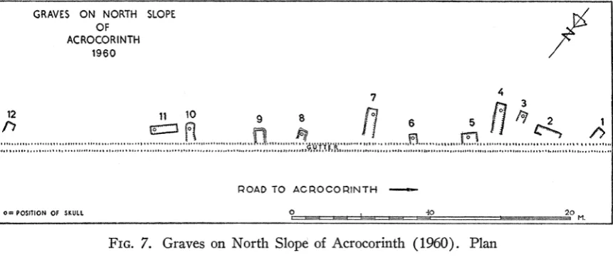
Bulldozers in 1958 and 1959 widened the road leading from the Hadji Mustafa spring up to the west gate of Acrocorinth so that it is now possible for tourist busses to make the ascent. In 1958 the machines cut through several graves on the slope, above Haghioi Anargyroi, west of the North Ravine. The guards of the Greek Antiquities Service collected some of the pottery from this disturbance and brought it to the Corinth Museum. In 1959 further work exposed more graves in the upper (south) scarp of the road, at the same location; reports of pillaging by small boys led us to undertake a salvage excavation with the intention of determining the char- acter and date of the cemetery. The Director, with six men, worked from June 6 to 10. In all, twelve graves were located, of which only one had completely escaped prior
GRAVES ON NORTH SLOPE OF
ACROCORINTH 1960
74
12 11 1 9 80 6 5
2l
POAD TO ACPOCOP NTH -
O-POSIOION Of SKULL ? __ b===4 I 20
- - ~ ~ ~~~~ - ~M.
FIG. 7. Graves on North Slope of Acrocorinth (1960). Plan
disturbance; of the others, most were well enough preserved to serve our purposes. The plan of the excavated area appears in Figure 7. No attempt was made to deter- mine the limits of the cemetery area; only those graves readily visible in the road scarp were excavated.
The graves were all cut into virgin soil, here a relatively compact mixture of reddish earth and clay. Many were cut with a wider shelf above the grave proper to support the lid of stone slabs (P1. 36, d) : graves # 2, 6, 9, 11, 12. Others had a lining for the sides of the grave, either of roof tiles (graves # 3, 7) or of slabs of poros limestone (# 4); the lids of these were composed of several slabs of limestone (#7; P1. 36, b) or of a number of large fieldstones (# 4). Two graves appear to have had lids of tiles, resting upon a shelf of virgin soil and weighted down with fieldstones