www.ijemst.com
Utilizing Geo-referenced Mobile Game
Technology for Universally Accessible
Virtual Geology Field Trips
Natalie Bursztyn1, Joel Pederson1, Brett Shelton2, Andrew Walker1, Todd Campbell3
1
Utah State University
2 Boise State University 3 University of Connecticut
To cite this article:
Bursztyn, N., Pederson J., Shelton, B., Walker, A., & Campbell, T. (2015). Utilizing
geo-referenced mobile game technology for universally accessible virtual geology field trips.
International Journal of Education in Mathematics, Science and Technology
,
3
(2), 93-100.
This article may be used for research, teaching, and private study purposes.
Any substantial or systematic reproduction, redistribution, reselling, loan, sub-licensing,
systematic supply, or distribution in any form to anyone is expressly forbidden.
Authors alone are responsible for the contents of their articles. The journal owns the
copyright of the articles.
Volume 3, Number 2, April 2015, Page 93-100
ISSN: 2147-611X
Utilizing Geo-referenced Mobile Game Technology for Universally
Accessible Virtual Geology Field Trips
Natalie Bursztyn1*, Joel Pederson1, Brett Shelton2, Andrew Walker1, Todd Campbell3 1Utah State University
2
Boise State University
3University of Connecticut
Abstract
Declining interest and low persistence is well documented among undergraduate students in Science, Technology, Engineering, and Math in the United States. For geoscience, field trips are important attractors to students, however with high enrollment courses and increasing costs they are becoming rare. We propose in this concept paper that the contextualized learning and engagement of field trips can be simulated by virtual field trips for smart mobile devices. Our focus is on utilizing the geo-referencing capabilities of smart devices within spatially scaled educational games. This technology is increasingly ubiquitous amongst undergraduate students, and consequently is an untapped pedagogical resource. The objective of our games is to give students real-world experience in selected fundamental principles of geology. Set in Grand Canyon, each module features images of exceptional geologic sites illustrating these principles. Students navigate “downstream” using their devices’ GPS and complete at least one interactive activity per location to progress to the next point. Student response to a pilot game suggests that this indeed is a viable method for making geoscience instruction engaging and enjoyable, and hopefully will result in greater motivation to pursue the geosciences.
Key words: Virtual field trip, Geoscience, Smart mobile device, GPS, STEM education, Educational technology.
Introduction
There is a well-documented and nationally reported trend of declining interest, low persistence, poor preparedness, and lack of diversity among U.S. students pursuing Science, Technology, Engineering, and Math (STEM) disciplines (e.g. Ashby, 2006; Fairweather, 2010; Seymour, 2001). In the case of geosciences, we suggest that a primary contributing factor is that introductory courses simply fail to inspire most students. Our experience as well as previous studies lead us to believe that field trips are often the most impactful component of lower division geoscience classes, and it is frequently hands-on field experiences that draw students into a geoscience major (Fuller, 2006; Kastens et al., 2009; McGreen & Sanchez, 2005; Orion & Hofstein, 1994; Tal, 2001).
Lower division introductory geoscience courses are typically taught in the form of a lecture and a complementary lab, not necessarily required to be taken concurrently, and commonly in large enrollment sections. Under such conditions, the ratio of students to instructors is high, which decreases the possibility of one-on-one interaction for each student and decreases the likelihood of a class field trip. High enrollment also increases the sense of student anonymity, consequently decreasing the students’ desire to take ownership of their learning, and reduces the potential for inspiring students to pursue the subject. These large enrollment undergraduate classes that cannot manage field trips fail to provide students with the opportunity to experience planet earth “in the wild” and the practices of geologists as they work to understand it. In addition, students often are excluded from field trips because of their physical limitations.
The contextualized physical learning of field trips, of being there, has the potential to be simulated with everyday technology. Recent research suggests that virtual field trips can be conducted through the use of smartphones and tablet computers (McGreen & Sanchez, 2005), already existing in most students’ hands. In this
*
94 Bursztyn, Pederson, Shelton, Walker & Campbell
concept paper we propose that new applications (apps) for mobile devices be developed for virtual field-trips that will enhance undergraduate student learning in the geosciences, will be accessible to students of diverse backgrounds and physical abilities, and will be easily incorporated into higher education programs and curricula at institutions globally. With a draft game we present as an example, student responses after experiencing it suggest this approach will be helpful for attracting and retaining the next generation of geoscience students.
Background
Benefit of Field Experiences
Field trips have long been a part of students’ educational experiences, particularly in Art, History, and Earth and Biological Science curricula. However, they are becoming increasingly more difficult to conduct at higher education institutions (McGreen & Sanchez, 2005). This difficulty is due to a combination of logistics and liability of travel, the high-enrollments of introductory courses, and decreasing financial and administrative support at government-sponsored colleges. Field excursions offer students opportunities to develop and practice the ability to distinguish features amid visual complexity and make scientific observations, identified as critical skills by Kastens et al. (2009). Field trips also provide primary experimental (hypothesis testing) experiences (Fuller, 2006; Orion & Hofstein 1994; Tal, 2001), analogous to the role of lab activities in physics and chemistry. This type of education has been called “contextualized learning” (McGreen & Sanchez, 2005), meaning that it occurs in rich physical environments filled with real-world connections and concepts.
The argument is that students retain more from a field trip than a classroom lab, and more in a lab than from a lecture for specific types of geoscience material. The teacher-student ratio and size of a lecture (often 100+ students) consistently outnumbers both a lab and a field trip (typically 10-25 students). Retention of material learned on field trips and in lab activities is possibly greater because these practical experiences fulfill the requisite components of contextualized learning introduced above (Kastens et al., 2009; McGreen & Sanchez, 2005). Research also supports the benefits in learning provided by models, visuals, and spatial-orienting activities, especially when these tools engage the learner and bring their attention to features they may have missed by simply reading text (Gobert, 2005). Spatial-orienting and illustrating tasks lead to deeper processing by structuring students’ knowledge acquisition and result in greater long-term retention compared to summarizing (Gobert, 2005; Gobert & Clement, 1999). Together these findings indicate that a visual interface requiring spatial-orienting tasks provides improved learning and retention over traditional text-based pedagogical approaches and static lab exercises.
Utilizing Smartphones Instead of Banning Them-Gaming in Undergraduate Education
Advancements in communication technology have outpaced implementation strategies within higher education teaching methodology. This communication technology gap is steadily increasing between incoming freshmen and educators (e.g. National Higher Education ICT Initiative 2007; Perlmutter, 2011; PIALP, 2013). Closing the gap can only lead to more engaging and meaningful educational experiences as undergraduate students and the general public are more and more attached to mobile devices (Dahlstrom et al., 2011; Johnson & Johnston, 2013; PIALP, 2013).
Smartphones are visually engaging, portable, WiFi and GPS-enabled, and ever-increasingly ubiquitous. They have become valuable learning tools for the general public in informal settings, for young children, and individuals with disabilities. Smart devices are also used in community and classroom data-collection exercises through basic apps that leverage the use of their various built-in sensors. Examples include the iSeismometer that makes use of the iPhone’s GPS and accelerometer to illustrate how seismic data is collected and the Theodolite app that makes use of the internal compass, inclinometer and GPS tools (Johnson & Johnston, 2013).
The use of smart mobile devices to simulate contextualized learning, drawing on technology already familiar to students, has been investigated. The results show that these tools allow students to concentrate on learning the material rather than how to use the equipment (Roschelle, 2003; McGreen & Sanchez, 2005; Clough et al., 2008). Geo-referenced, mobile-learning games (MLGs) can enhance student interest in introductory geoscience courses by providing the physical learning experience of field trips without added costs, accessibility and liability issues.
ecology called “Savannah”. The researchers used GPS to gain positional information on players, the children, roaming around an open field that was spatially scaled down to represent a virtual African savannah. This geo-referenced activity enabled the children to role-play as lions while exploring the space looking for resources (game and water) to help them survive. Instead of being told about life in the plains of Africa, the children (lions) fought to stay alive (virtually) in the Savannah by successfully hunting prey. The authors believe their game was an engaging learning experience for the children, and also enjoyable in its physicality. Another example of geo-referenced gaming is in the work of Shelton et al. (2012) who recently examined the use of mobile devices for an educational math game (GeePerS Math) that targets deaf and hard-of-hearing K-12 children. The game is introduced as a superhero training program and the children are faced with word problems that are signed to them by an avatar in the game.
Players must solve the simple addition or subtraction problem in order to proceed to the next location and complete their mission. For example, “You saw six trees at the entrance, and took the path with four trees. How many trees did you pass in the forest?” The concept of exploring a virtual world to learn math was based on previous work that showed that virtual reality technology games improved the ability of deaf children to think flexibly and critically. Similar to Savannah, GeePerS Math generated positive feedback from teachers about the physical experience of the game, e.g.: “I really like that we have them up out of their seats moving” (Shelton et al. 2012).
Although games and/or mobile devices have been examined and used extensively for K-12, there is little known research addressing the cognitive elements of geo-spatial learning when applied as educational tools in undergraduate science courses. According to Squire and colleagues (2007), games and mobile games in particular are tools that enhance learning when designed and implemented effectively with curriculum and instruction. With the prevalence on college campuses of handheld devices such as smartphones, tablets and notebook computers (Dahlstrom et al., 2011; Johnson & Johnston, 2013), there is untapped potential for their use to explore virtual worlds in real geo-referenced outdoor spaces. Only a few years ago the majority of undergraduate students owned smartphones and tablets: today they are mostly ubiquitous (Clough et al., 2008; Dahlstrom et al., 2011; Johnson & Johnston, 2013; McGreen & Sanchez, 2005). Consequently, mobile devices have been attracting the attention of researchers and educators for their potential as learning tools for K-12 and in informal settings.
This technology provides new genres for learning, and mobile devices bring unlimited access to communication and technology. The accessibility allows a transition from occasional usage of a computer lab by a class to the frequent and integral use of portable technology in any setting. Educational games give students the opportunity to participate in “other worlds”; and evidence suggests that simulations increase motivation as well as teach problem solving strategies (Klopfer et al., 2003).
Game Design and Assessment Methods
Game Design
The MLG modules we are testing use geo-referenced mobile technology on both Android and iOS platforms to teach geologic concepts in the context of real world examples. Our goal is to enhance undergraduate student learning, engagement and retention in the geosciences through the design, creation, and implementation of a series of geo-referenced MLGs. Student engagement is targeted with the MLG modules through the use of real world examples and imagery, instant feedback on content, and hands-on interactive activities. In terms of content, the focus is on the “Big Ideas” of Geology and commonly held misconceptions about them (ESLI, 2009). The games are designed to be used as supplementary introductory laboratory exercises for Physical Geology, Earth System Science, and Historical Geology courses.
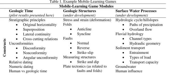
Each module was structured around a broad construct of introductory geology curriculum (Table 1), from which suitable locations within Grand Canyon were selected as virtual field trip stops. The questions and interactive touch-screen activities for these locations were written and refined by the authors as well as collaborating faculty from the MLG testing institutions. For each module a location map of all field trip stops and a storyboard of images, questions and activities was assembled for the development of the applications.
96 Bursztyn, Pederson, Shelton, Walker & Campbell
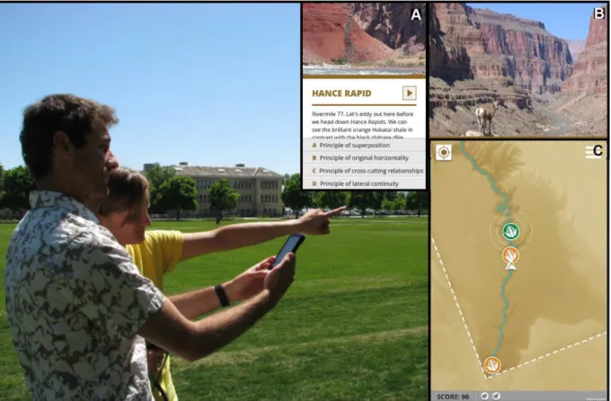
Grand Canyon – physically moving around in whatever real location the student is in using their smart phone or tablet (Figure 1). The program aims to assist students in learning spatial reasoning and orientation by becoming familiar with the use of a compass and map to locate themselves and actually move to each new location on foot or in a wheelchair.
Figure 1. Two students orient themselves. Inset A: screenshot of a question with playable video. Inset B: screenshot of a Grand Canyon location. Inset C: screenshot of basemap showing complete (orange) and
incomplete (green) locations.
Curriculum Constructs
The Earth Science Literacy Initiative (ESLI) defined nine “Big Ideas” of Earth science that all citizens should know (2009). Following this publication, the Michigan Teacher Excellence Program (MiTEP) identified several commonly held misconceptions for each of these “Big Ideas” (Engelmann and Huntoon 2011). Based upon these “Big Ideas” and misconceptions, the pilot MLG module we present results of here considers Big Idea #2: “Earth is 4.6 billion years old” and the misconceptions that “geologic time can be described using hundreds of years” and that “rock layers are always flat” as the bases for creating a module addressing geologic time. A crucial objective of this module is to include the standard curriculum themes of relative age, the geologic column, and numerical age. Within this curriculum, the main focus is on relative age, which includes the subjects of stratigraphic principles, gaps in the rock record and fossils and correlation.
ESLI uses Grand Canyon as the real world example for this “Big Idea” because it is a famous geologic landscape that provides excellent learning opportunities and since it is frequently used as the example of stratigraphy and unconformities (gaps in the rock record) in introductory geology textbooks, it is an ideal game setting to teach these concepts. Following suit, the Geologic Structures and Surface Water Processes MLG modules under development are connected to ESLI’s Big Idea #4: “Earth is continuously changing” and Big Idea #5: “Earth is a water planet” (Table 1).
Table 1. Example Mobile-Learning Games
Mobile-Learning Game Modules Geologic Time
(pilot results presented here)
Geologic Structures
(under development)
Surface Water Processes
(under development) Co ns truct s Stratigraphic principles
Original horizontality
Superposition
Lateral continuity
Cross cutting relations Unconformities
Disconformity
Nonconformity
Angular unconformity Relative dating
Numeric dating
Human vs geologic time
Stress and strain (deformation) Folds Anticline Syncline Faults Normal Reverse Strike-slip Measuring structures
Strike and dip Plate tectonics (as related to
faults and folds)
Hydrologic cycle/hillslopes
Paths of precipitation
Overland flow Fluvial hydrology
Channel types
Hydraulic geometry Sediment transport
Entrainment
Types of load
Transport capacity Groundwater
Human influence
Answering questions incorrectly triggers a pop-up explanation of the answer the student selected and the player is then returned to the question and remaining answers. Each time a question is answered incorrectly, the number of points that can be earned for selecting the correct answer is reduced, thus reducing the total score that can be achieved upon completion of the game. This feature provides instant feedback on content comprehension to the player and provides the opportunity to beat a previous score by replaying the game and answering the questions again (correctly) with fewer attempts. A second type of question in the game platform requires the students to examine a photograph and identify a specific geologic feature by tapping or swiping the feature on the touchscreen. This interactive element requires observation and critical thinking skill about the content and its application in the real world example of Grand Canyon.
Assessment Design
Assessment will be addressed through a pre- and post-intervention research design that leverages the validity of disseminating across several different institutions, instructors, and student populations. In addition to content evaluation, three instruments encompassing motivation, interest, and attitude (MIA) will be used. All three measures will be used at the beginning of the semester and after all the interventions are complete. Reliability in the form of Cronbach’s alpha and confirmatory factor analyses will be conducted for all instruments with the data we collect.
We are also gathering data of tracked responses to activity questions during game play at collaborating institutions. These embedded items are checks of student understanding immediately after exposure to the content of the MLGs. Finally, demographics about students (ethnicity, gender, socio-economic status, etc.) and the institutions (4-year land grant, 2-year community college, private, etc.) will be gathered for use in a Hierarchical Linear Modeling (HLM) analysis.
Student Feedback on Pilot Game
98 Bursztyn, Pederson, Shelton, Walker & Campbell
Table 2. Summary feedback from students on pilot MLG
Strengths
Outside
Not in classroom
Orienteering/exploring
Walking/not stationary Photographs
Real world examples
Not cartoons/drawings
Like “actually” studying Grand Canyon Interactive
Working in partners
Touchscreen
Photos appear only once location is reached
Feedback on wrong answers Not writing
Positive commentary from the students was encouraging especially considering the objectives of increasing undergraduate student engagement and retention in the geosciences. The first of the positive feedback comments was simply the experience of being outdoors, for example:
“I like being able to walk around and orient myself with a map. It is great to leave the classroom.”
In addition to several comments about “feeling like an explorer”, it was clear that the use of cardinal directions and even the understanding of a GPS system for orienteering was embarking on unfamiliar territory for some students, for example: “I liked how the directions in the game were the same as the directions are here in Logan.”
The second item, the use of real photographs to represent concepts in geology, also received positive feedback: “I liked how it put what we were learning into real examples that had us out in the field as we would be if we were studying the canyon”
“I liked that it had real pictures and a game-like premise rather than drawing in a lecture-style class. It’s always more fun to get up and move while learning”
The third positive aspect, the interactivity of the MLG, ranged from student to student for what interactive part they enjoyed, however a standout point is that some recognized the instant feedback component and felt its importance:
“I liked answering the questions and if you were wrong it would explain why.”
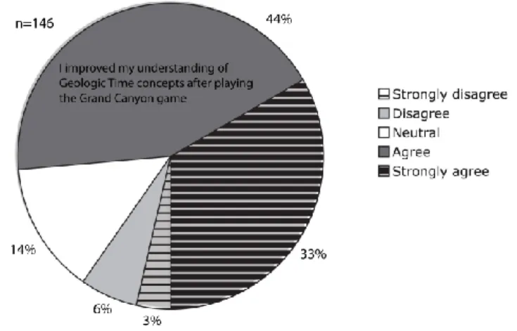
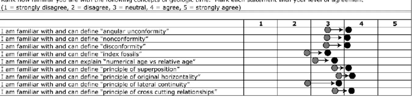
Pilot survey results also indicated that students across the board (77%) gained greater confidence in their comprehension of the content covered in the game, on average having ranked themselves around 3 (“neutral”) for initial familiarity and around 4 (“agree”) for subsequent familiarity of the concepts (Figures 2 and 3). Broader challenges that we face include difficulties with screen visibility in full sunlight, playability in rainy and winter weather, cloudiness impacting GPS sensitivity, and varying GPS sensitivity across devices.
Figure 3. Results of the students’ self-assessment survey of geoscience concepts showing average of responses before game-play in grey to after game-play in black (n=146).
Discussion and Conclusion
Field trips have been well established as a successful method for engaging students, but they are increasingly becoming prohibitive. As geoscience educators look for solutions to the declining enrollment at institutions of higher education, mobile games have the potential to be engaging and instructional when combined into virtual fieldtrips. Early feedback from our prototype testing suggests that this approach of virtual field trips using mobile smart devices does enhance student engagement within large enrollment classes. This project presents geo-referenced MLGs set in Grand Canyon as a relatively affordable and highly accessible means for geoscience educators to leverage the smartphone technology already in use by students in a way that aligns with existing curriculum.
We have refined all the MLGs with collaborating instructors from a range of higher education institutions across the country and are testing the modules in classes at the collaborating institutions spanning a diversity of student backgrounds from community colleges to private universities. These MLG modules will all be evaluated with pre and post content and MIA assessment. The large datasets arising from this study will be subject to statistical (HLM) analysis that will include an examination of the correlation between students’ demographics and their learning gains.
The results of our early assessments are positive and encouraging for increasing student engagement, especially considering the overall enjoyment of learning with mobile technology despite the buggy operability of the pilot module. Most students found the experience enjoyable and felt it helped them improve their comprehension and understanding of the curriculum, suggesting that this tool allows students to concentrate on the content of the game instead of using cognitive effort to deal with how to play it. Thus educators can take advantage of learning with technology rather than from technology by integrating mobile devices into their teaching (Campbell et al. 2010). This finding is very encouraging for our pilot in that it indicates we have a viable method for enjoyable and engaging undergraduate geoscience education that has the potential to increase engagement and retention by merging students’ highly digital and mobile world with their college education. In essence, it helps by closing the existing communication technology gap described earlier. It is an initial step in developing innovative pedagogy that utilizes powerful tools students are already intimate with in order to make first-year STEM courses more engaging and interactive and to make world-class field trips accessible to all.
References
Ashby, C. (2006). Science, technology, engineering, and mathematics: Trends and the role of federal programs.
Testimony before the Committee on Education and the Workforce, House of Representatives. http://republicans.edlabor.house.gov/archive/hearings/109th/fc/competitiveness050306/ashby.htm. Accessed 1 October 2012.
Benford, S., Rowland, D., Flintham, M., Drozd, A., Hull, R., Reid, J., Morrison, J., & Facer, K. (2005). Life on the edge: Supporting collaboration in location-based experiences. Papers: Public Life, April 2-7, Portland, Oregon.
100 Bursztyn, Pederson, Shelton, Walker & Campbell
Clough, G., Jones, A.C., McAndrew, P., and Scanlon, E. (2008). Informal learning with PDAs and smartphones.
Journal of Computer Assisted Learning, 24, 359-371.
Dahlstrom, E., de Boor, T., Grunwald, P., & Vockley, M. (2011). The ECAR National Study of Undergraduate Students and Information Technology. Research Report. EDUCAUSE Center for Applied Research: Boulder, CO. http://www.educause.edu/ecar. Accessed 16 May 2012.
Earth Science Literacy Initiative (ESLI) (2009). Earth science literacy principles. http://www.earthscienceliteracy.org/document.html. Accessed 25 January 2012.
Engelmann, C.A. & Huntoon, J.E. (2011). Improving student learning by addressing misconceptions. Eos, Transactions, American Geophysical Union, 92(50), 465-476.
Fairweather, J. (2010). Linking Evidence and Promising Practices in Science, Technology, Engineering, and Mathematics (STEM) Undergraduate Education: A Status Report for The National Academies National Research Council Board of Science Education (BOSE). BOSE, Washington, DC; www7.nationalacademies.org/bose/Fairweather_Commissioned-Paper.pdf. Accessed 1 October 2012. Fuller, I.C. (2006). What is the value of fieldwork? Answers from New Zealand using two contrasting
undergraduate physical geography field trips. New Zealand Geographer, 62, 215–220.
Gobert, J.D. (2005). The effects of different learning tasks on model-building in plate tectonics: diagramming versus explaining. Journal of Geoscience Education, 53(4), 444-455.
Gobert, J.D. & Clement, J.J. (1999). Effects of student-generated diagrams versus student-generated summaries on conceptual understanding of causal and dynamic knowledge in plate tectonics. Journal of Research in Science Teaching, 36(1), 39-53.
Johnson, Z.I. & Johnston, D.W. (2013). Smartphones: powerful tools for geoscience education. Eos, 94(47), 433-456.
Kastens, K.A., Manduca, C.A., Cervato, C., Frodeman, R., Goodwin, C., Liben, L.S., Mogk, D.W., Spangler, T.C., Stillings, N.A., & Titus, S. (2009). How geoscientists think and learn. eos, 90(31), 265–272. Klopfer, E., Squire, Lk, & Jenkins, H. (2003). Augmented reality simulations on PDAs. Paper presented at the
2003 American Education Research Association (AERA) Conference, Chicago, IL.
McGreen, N. & Arnedillo Sánchez, I. (2005). Mapping challenge: A case study in the use of mobile phones in collaborative, contextual learning. Short paper in IADIS International Conference Mobile Learning. Qawra, Malta.
National Higher Education ICT Initiative (2007). Succeeding in the 21st century: What higher education must do to address the gap in Information and Communication Technology proficiencies. Research Report. Educational Testing Service. http://www.ets.org/Media/Tests/ Information_and_Communication_ Technology_Literacy/ICTwhitepaperfinal.pdf. Accessed 25 April 2012.
Orion, N. & Hofstein, A. (1994). Factors that influence learning during a scientific field trip in a natural environment. Journal of Research in Science Teaching, 31, 1097-1119.
Perlmutter, D.D. (2011). Bridging the Generational Tech Gap. News article. The Chronicle of Higher Education. http://chronicle.com/article/Bridging-the-Generational-Tech/128304/ Accessed 25 April 2012.
Pew Internet & American Life Project (PIALP), Adult gadget ownership over time, January 2013, http://www.pewinternet.org/Trend-Data-%28Adults%29/Device-Ownership.aspx. Accessed 12 February 2013.
Roschelle, J. (2003). Unlocking the learning value of wireless mobile devices. Journal of Computer Assisted Learning, 19, 260-272.
Seymour, E. (2001). Tracking the processes of change in U.S. undergraduate education in science, mathematics, engineering, and technology. Science Education, 86, 79-105.
Shelton, B.E., Parlin, M.A., Jump, V., & Rowan, L. (2012). Iterative technology-based design with deaf/hard of hearing populations: Working with teachers to build a better educational game. Proceedings of the International Conference of the Learning Sciences (ICLS 2012), Sydney, Australia.
Squire, K. D., Jan, M., Matthews, J., Wagler, M., Martin, J., Devane, B., & Holden, C., (2007). Wherever you go, there you are: Place-based augmented reality games for learning. In B. E. Shelton & D. Wiley (Eds.), The Design and Use of Simulation Computer Games in Education (pp. 265-294). Sense Publishers: Rotterdam, The Netherlands.
Tal, R.T. (2001). Incorporating field trips as science learning environment enrichment - an interpretive study.