! !
STAKEHOLDER NETWORK INFLUENCES ON LOCAL-LEVEL HAZARD MITIGATION PLANNING OUTPUTS
Lindsey Ward Lyles
A dissertation submitted to the faculty of the University of North Carolina at Chapel Hill in partial fulfillment of the requirements for the degree of Doctor of Philosophy in the
Department of City and Regional Planning
Chapel Hill 2012
Approved by:
Dr. Philip R. Berke
Dr. David R. Godschalk
Dr. Nikhil Kaza
Dr. Gavin P. Smith
! """! ABSTRACT
LINDSEY WARD LYLES: Stakeholder Network Influences on Local-Level Hazard Mitigation Planning Outputs
(Under the direction of Philip Berke)
Economic losses from natural hazards have increased dramatically and climate change is expected to exacerbate underlying hazard risks. There is widespread consensus that development in hazardous locations as a major cause of increased losses and land use approaches to guide people and property to safer locations are the most effective long-term ways to mitigate long-term hazard risks (e.g. Mileti 1999). Since passage of the Disaster Mitigation Act of 2000 (DMA), local governments are required to adopt hazard mitigation plans developed by networks of stakeholders through planning processes typically led by emergency managers and sometimes including local planners. This new inter-governmental policy framework offers an unique opportunity to examine 1) factors leading to greater use of land use approaches to mitigate hazards and 2) the influence of planners embedded in stakeholder networks in which they are rarely the central, coordinating stakeholder.
! "#!
hazard mitigation stakeholder surveys, interviews, and in-person visits, as well as document review and secondary data.
Regression model findings indicate statistically significant positive relationships between involvement of local planners and incorporation of more land use approaches. Case study findings show that stronger bonding connections between emergency managers and local planners have contributed to greater incorporation of land use approaches. The case study findings also indicate that network structures with a balance of bonding and bridging connections have contributed to greater incorporation of land use approaches than more hierarchical network structures. Research
!
! #! !
DEDICATION
! #"!
ACKNOWLEDGEMENTS
I will be forever grateful for the mentoring I received from my dissertation committee chair, Dr. Philip Berke. It has been an honor and a pleasure to be his student and I have learned much more from him than I could have imagined when I started this process. The encouragement and critiques I received from my dissertation committee members, Dr. David Godschalk, Dr. Nikhil Kaza, Dr. Gavin Smith, and Dr. Yan Song, substantially improved this monograph and my thinking. Fellow doctoral students have formed an invaluable support network on many levels. It has been a pleasure to share this experience with Augustus Anderson, Tab Combs, Mary Donegan, Hye-Sung Han, Marc Howlett, Justin Kirkland, Anna Osland, Danielle Spurlock, and Mark Stevens. The same is true for the
masters’ students who I have worked with on research projects and whose efforts have generated data used in this dissertation: Meg Aminto, Caroline Cunningham, Casey Dillon, Frank Glover, Mikey Goralnik, Ted Mansfield, Rachel Meyerson, Chandler Van Schaack, Casey Weissman-Vermeulen, and my fellow Duke hoops fan, Sara Reynolds. Tom Carsey, Skyler Cranmer, Nichola Lowe, Laurie Maffly-Kipp, Paul Mihas, Sally Morris, Dave Salvesen, and my research participants gave generously
of their time and expertise. I deeply appreciate the support provided by a Royster Fellowship from the Graduate School and a PERISHIP Fellowship from the National Science Foundation, the University of Colorado Hazards Center, Swiss Re, and the Public Entity Risk Institute.
As much as I owe to those listed above, my deepest gratitude goes to my family: my wife, our boys, my parents, and all of our family.
! #""!
TABLE OF CONTENTS
1. Hazard Mitigation, Land Use Planning and Stakeholder Networks ………...…….... 1
1.1. The Need for Land Use Approaches in Hazard Mitigation Planning ……….. 1
1.2. Hazard Mitigation: A Critical Phase of The Disaster Management Cycle... 3
1.3 Land Use Approaches Can Reduce or Eliminate Hazard Risk ………. 5
1.4. The Federal Hazard Mitigation Policy Context ………... 6
1.5. The Roles of Emergency Managers and Local Planners in Mitigation Stakeholder Networks … 8 1.6. Research Questions ………….………..……….….… 11
1.7. A Social Networks Approach to Hazard Mitigation Planning …….………..…… 12
1.8. Conclusion ……….………. 19
2. Literature Review ……….………. 22
2.1. Introduction ………..….. 22
2.2. Planning Outputs …..……….………..23
2.2.a. Plan Quality Evaluation ……….………..……….….. 25
2.2.b. Plan Implementation Evaluation ………….……….……….. 27
2.3. Social Network Approaches ………28
2.3.a. Social Network Analysis ………. 29
2.3.b. Communication, Collaboration and Networks ………...…... 34
2.3.c. Social Network Analysis Applications in Planning ………...….... 37
2.3.d. Social Network Analysis in Planning-Related Disciplines ……….……….... 39
2.3.e. SNA in the Hazard and Disaster Management Policy Domain …….………...…… 42
! #"""!
2.4.a. Local Hazard Mitigation Plan Quality ………….………..………. 44
2.4.b. Hazard Mitigation Planning Processes ………….……….……….……. 45
2.4.b.1. The Role of Stakeholder Diversity in Hazard Mitigation ... 45
2.4.b.2. The Role of Local Planners in Mitigation Planning Processes ...… 49
2.4.c. Federal and State Planning Policy Context ……….……….……….. 53
2.4.d. Local Community Characteristics ……….……….……… 55
2.5. Conclusion ………...……….…. 59
3. Conceptual Framework for Predicting Land Use Planning Outputs from Hazard Mitigation Planning Processes ……….……….. 60
3.1. Introduction ……….……….... 60
3.2. Conceptual Framework Overview …….………. 61
3.3. Conceptual Dimensions ……….…………..………..……… 63
3.3.a. Plan Quality ………..………..…. 63
3.3.b. Plan Implementation …………..………. 64
3.3.c. Stakeholder Network Diversity ………..………. 65
3.3.d. Stakeholder Network Structure ………..………. 67
3.3.e. State Planning Policy Context ………..……... 69
3.3.f. Local Community Context ……….………. 70
3.3.g. Feedback Relationships ……….. 71
3.4. Hypothesized Relationships ………..………. 72
3.5. Conclusions ………..……….. 72
4. Research Design and Methodology………..………...……….. 75
4.1 Research Design and Methodology Overview ……….….…….. 75
4.2 Phase 1 Sample Selection ……….….…….. 77
4.2.a. State Selection ………..…...…… 77
! "$!
4.3. Phase 1 Data Collection ………..…… 78
4.3.a. Plan Quality Content Analysis Overview ……….. 78
4.3.a.1. Plan Collection ………...……. 78
4.3.a.2. Coding Instrument Development and Testing ……….…….…. 78
4.3.a.3. Coding Procedures ……….……… 79
4.3.a.4. Creation of Plan Quality Indexes and Counts ……….……….. 79
4.3.b. Phase 1 Secondary Data Collection ……….….…... 80
4.4. Phase 1 Analytical Techniques ………..81
4.4.a. Model Selection ……….………. 81
4.4.b. Model Diagnostics ……….……… 82
4.5. Phase 1 Variables ……….. 82
4.5.a. Dependent Variables ……….……….. 82
4.5.b. Independent Variables ……… 84
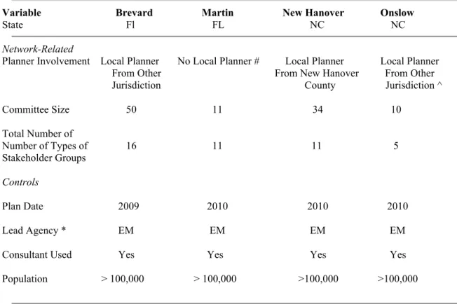
4.6. Phase 2 Sample Selection ……….. 87
4.6.a. Jurisdiction Selection for Case Studies ……….. 88
4.6.a.1. Selection of Jurisdictions in which to Conduct Surveys ………...…. 88
4.6.a.2. Selection of Stakeholders for Web-Based Survey ……….… 92
4.7. Stakeholder Survey Data Collection ……….. 93
4.7.a. Survey Questionnaire Development and Design ……….….. 94
4.7.b. Survey Questionnaire Administration ….………..……… 95
4.7.b.1. Pre-Testing and Institutional Review Board Approval ……… 96
4.7.b.2. Survey Questionnaire Administration ………...….... 96
4.7.c. Analysis of Survey Data ……… 97
4.7.c.1. Analysis of Individual Attribute Questions ………... 97
4.7.c.2. Analysis of Stakeholder Network Questions ……… 98
! $!
4.8.a. Selection of Semi-Structured Interview Sample ………..…. 98
4.8.b. Semi-Structured Interview Data Collection……….. … 99
4.8.b.1. Interview Protocol Development and Approval……….. … 99
4.8.b.2. Interview Scheduling and Administration ………..…. 100
4.8.c. Interview Content Analysis ……….…. 101
4.9. Secondary Document Selection, Collection and Analysis ...…. 101
4.9.a. Secondary Document Selection ………...…. 101
4.9.b. Secondary Document Collection ……….…. 102
4.9.c. Secondary Document Analysis ………. 102
4.10. Case Study Analysis ……….. 102
4.10.a. Individual Case Analysis ………..….. 102
4.10.b. Cross-Case Analysis ………..…. 105
4.11 Omitted Variables ……….106
5. Predicting the Incorporation of Land Use into Hazard Mitigation Plans ………... 109
5.1 Overview of Regression Models ……….………….109
5.2 Predicting the Incorporation of Land Use Approaches in Fact Bases ....………….……… 112
5.3. Predicting the Proposal of Land Use Policies in Mitigation Strategies ……….…. 116
5.4. Predicting the Inclusion of Implementation Information for Land Use Policies Proposed in Mitigation Strategies ………... 120
5.5 Discussion and Conclusions ……….……..…….. 123
6. Explaining the Influence of Planner Involvement………. 130
6.1 State Planning Policy Contexts for Florida and North Carolina ………... 130
6.1.a. State Coordination of Local Land Use Planning ………... 131
6.1.b. State Coordination of Local Mitigation ………. 132
6.2. Comparative Analysis of Four Cases ………... 135
! $"!
6.2.b. The Influence of Network Characteristics on Planning Outputs ………. 138
6.3. Conclusion ………..… 150
7. Conclusion ……….………. 151
7.1 Hypotheses Revisited and Concluding Observations ………..………. 153
7.1.a. Hypotheses Revisited ………...… 153
7.1.b. Related Findings and Considerations ………... 155
7.1.c. Concluding Observations ………. 157
7.2 Future Research and Policy Recommendations ………..……….. 158
7.2.a. Future Research Recommendations ………. 158
7.2.b. Policy and Practice Recommendations ……….... 161
Appendix I. Supplemental Information on Research Design and Methods ………... 164
Appendix II. More is Less in Brevard County ……….. 186
Appendix III. Strong but Stove Piped in Martin County ……….... 210
Appendix IV. Tenuous Ties in Onslow County ……….... 232
Appendix V. Making the Connections in New Hanover County ……….... 259
Appendix VI. Supporting Data for Case Studies ……….………. 288
Appendix VII. Data Collection Instruments ………...……….. 291
! $""!
LIST OF TABLES
Table 1.1. Land Use Policies and Tools and Mitigation Applications ………..… 6
Table 2.1. Direction Setting and Action Oriented Plan Quality Principles ………. 26
Table 2.2. Boundaries in Governance Networks ………. 41
Table 2.3. Hazard Mitigation Indicators for Plan Quality Principles ……….. 45
Table 4.1 State Planning Policy Context Characteristics ……….77
Table 4.2. Counties and Municipalities by State ………. 78
Table 4.3. Land Use Actions Assessed in Plans ……….. 80
Table 4.4. Dependent Variables ……….. 83
Table 4.5 Independent Variables ………. 85
Table 4.6. Case Study County Characteristics ……… 91
Table 4.7. Survey Response Rates for Four Case Studies … ……….. 97
Table 4.7. Agencies Whose Representatives Were Interviewed ………... 101
Table 5.1 Predicted Pattern of Relationships Between Independent and Dependent Variables ...… 111
Table 5.2. Explaining Assessment of Land Use Approaches in Fact Base ………..………….…… 113
Table 5.3. Explaining Proposal of Land Use Policies ………..…………..………... 117
Table 5.4. Explaining Inclusion of Implementation Information for Land Use Policies ……..…… 121
Table 5.5. Summary of Relationships Between Independent Variables and Land Use-Related Plan Quality ………... 124
Table 6.1. Land Use Approaches Included in Future-Oriented Mitigation Strategies ……….. 137
Table 6.2. Network Characteristics in Four Case Counties ………..……. 139
Table I.1. Descriptive Statistics for Assessment of Land Use Capabilities in the Fact Base …...… 168
Table I.2. Descriptive Statistics for Proposed Land Use Actions (Policies Principle) …..………… 169
Table I.3. Descriptive Statistics for Implementation Information (Implementation Principle) …… 170
Table I.4. Descriptive Statistics for State Planning Mandate ……… 171
! $"""!
Table I.6. Stakeholder Group Types ………. ……… 172
Table I.7. Descriptive Statistics for Committee Diversity ……… 172
Table I.8. Descriptive Statistics for Population Density ..……… 173
Table I.9. Descriptive Statistics for Population Growth ………...…… 174
Table I.10. Descriptive Statistics for Median House Value ………..……… 175
Table I.11. Descriptive Statistics for Number of Disasters ..……….… 176
Table I.12. Counties by State and Plan Adoption Date ………. 177
Table II.1 Committee Members’ Self-Reported Efforts to Implement Land Use Actions ……..…. 197
Table II.2 Brevard County Stakeholder Views of Effectiveness of Mitigation Approaches ……….201
Table III.1 Committee Members’ Self-Reported Efforts to Implement Land Use Actions ……….. 219
Table III.2 Martin County Stakeholder Views of Effectiveness of Mitigation Approaches ..……... 224
Table IV.1 Committee Members’ Self-Reported Efforts to Implement Land Use Actions ……….. 244
Table IV.2 Onslow County Stakeholder Views of Effectiveness of Mitigation Approaches ……... 249
Table V.1 Committee Members’ Self-Reported Efforts to Implement Land Use Actions ……….. 271
Table V.2 New Hanover County Stakeholder Views of Effectiveness of Mitigation Approaches... 277
Table II.1. Socio-Economic Characteristics of Case Study Counties ………...… 288
Table II.2. Committee Member Experience ………...………...… 289
Table II.3. Committee Member Skills and Authorities ………..………...… 289
! $"#!
LIST OF FIGURES
Figure 1.1. Actions Included in DMA-Compliant Local Mitigation Plans by FEMA Categories of
Approaches ………. 8
Figure 1.2. Preferential Attachment ……… 15
Figure 1.3. Small World Characteristics ………. 17
Figure 2.1. Small World Network ………... 32
Figure 2.2. Village Network ………...…. 32
Figure 2.3. Opinion Leader Network ……….. 32
Figure 2.4. Hierarchical Network ……….... 32
Figure 3.1. Conceptual Framework ………. 63
Figure 6.1 More is Less in Brevard County ………..… 146
Figure 6.2. Strong but Stove Piped in Martin County ………... 147
Figure 6.3. Tenuous Ties in Onslow County ………... 148
Figure 6.4. Making the Connections in New Hanover County ………...………..… 149
Figure I.1. Visualization of Degree Centrality ……….……. 184
Figure I.2. Visualization of Betweenness Centrality ………...……….…… 185
Figure II.1. Map of Brevard County Showing Storm Surge Zones ………... 190
Figure II.2. Excerpt of Brevard County Code of Ordinances Included in LMS ……...……… 193
Figure II.3. Brevard County Information Sharing Network ……….. 204
Figure III.1. Map of Martin County Showing Flood Zones ………..… 212
Figure III.2. Excerpt of Martin County Comprehensive Plan Objectives and Policies Included in LMS ……… 215
Figure III.3. Photo Illustrating Martin County’s Height Limit and Palm Beach County’s Beachfront High Rises ………. 216
Figure III.4. Excerpt of Project Prioritization List ……… 218
! $#!
Figure IV.1. Map of Onslow County Showing Flood Hazard Zones …………..……… 235 Figure IV.2. Examples of Mitigation Strategies and Associated Implementation Information …… 241 Figure IV.3. Onslow County Information Sharing Network ………..……….. 251 Figure V.1. Map of New Hanover County and Jurisdictions ………..……..………... 262 Figure V.2. Examples of Mitigation Actions and Associated Implementation Information …..…... 268 Figure V.3. New Hanover County Information Sharing Network ………..….. 280
!
Chapter 1
Hazard Mitigation, Land Use Planning
and Stakeholder Networks
1.1. The Need for Land Use Approaches in Hazard Mitigation Planning
Economic losses due to natural hazard events have been growing dramatically for nearly two
decades (Mileti 1999, Cutter 2001). The 2004 and 2005 hurricane seasons alone resulted in excess of
$150 billion in damages and more than 1000 lives lost (Pielke et al. 2008, National Hurricane Center
2010). Development of hazard-prone locations placing higher levels of people and property at risk is
a major cause of increasing losses (Burby 1998, Burby 2006, Berke and Smith 2010). Meanwhile,
confidence increases that anthropogenic climate change exacerbates existing threats from natural
hazards, particularly floods, droughts, and extreme events like hurricanes (Karl, Thomas, Melillo
2009). In the future, ‘mega-catastrophes’ resulting in billions of dollars in losses may become the
norm rather than the exception to the rule (Peacock et al. 2008). In light of the local, state, national
and international consequences of growing losses, interest in long-term reductions in risks is strong
among practitioners and researchers alike. Long-term risk reduction efforts are known as natural
hazard mitigation, which has been defined as “advance action taken to reduce or eliminate the
long-term risk to human life and property from natural hazards” (Godschalk et al. 1999 p. 5).
Hazard mitigation plans and implementation of those plans can reduce vulnerability to hazard
threats and contribute to a more sustainable and resilient society (Berke and Smith 2010). At the
local level, benefits of mitigation plans include consolidating knowledge of the hazards,
!
"!
and meeting federal requirements to adopt mitigation plans. A less obvious but also important benefit
of a hazard mitigation plan is that the planning process can bring together a diverse group of
stakeholders that might not work together on mitigation otherwise, or in some cases not work together
at all. The process of working together to develop the plan may help those stakeholders build
ongoing relationships and be more effective in meeting community goals.
Multiple categories of approaches for mitigating hazards are available to local communities
for inclusion in their hazard mitigation plans. Approaches include property protection (e.g. elevating,
retrofitting, or acquiring properties), structural controls (e.g. dams, levees and seawalls), public
information (e.g. education campaigns), natural resource protection (e.g. preservation of wetlands and
dunes) and preventative land use approaches (e.g. zoning and subdivision ordinances). For much of
the twentieth century, structural controls were the primary approach, especially for flood
management, although they were criticized for providing a false sense of security that induced new
development in hazardous areas and damaging natural features that provide inherent hazard
mitigation benefits (e.g. wetlands that store flood waters) (Godschalk, Brower and Beatley 1989,
Burby et al. 1999, Burby 2006). Non-structural approaches (e.g. land use planning, building codes
and public information) began to be more seriously considered in the 1960s and 1970s (Godschalk,
Brower and Beatley 1989).
Repeated national level reports and studies have argued that land use approaches provide the
best opportunities for reduction or even elimination of long-term hazard risks (Godschalk, Brower
and Burby 1989, Burby 1998, Godschalk et al. 1999, Burby et al. 1999, NRC 2006, Berke and Smith
2010). Yet, research has shown local hazard mitigation planning is generally of mediocre quality and
integration of land use approaches with hazard mitigation is typically underdeveloped (Berke and
French 1994, Burby and Dalton 1994, Berke et al. 1996, Burby and May 1997, Deyle and Smith
1998, Brody 2003, Burby 2003, Tang et al. 2008, Kang et al. 2010, and Berke, Smith and Lyles
2012.) Thus, the overarching motivation for this research is to increase understanding of factors that
!
#!
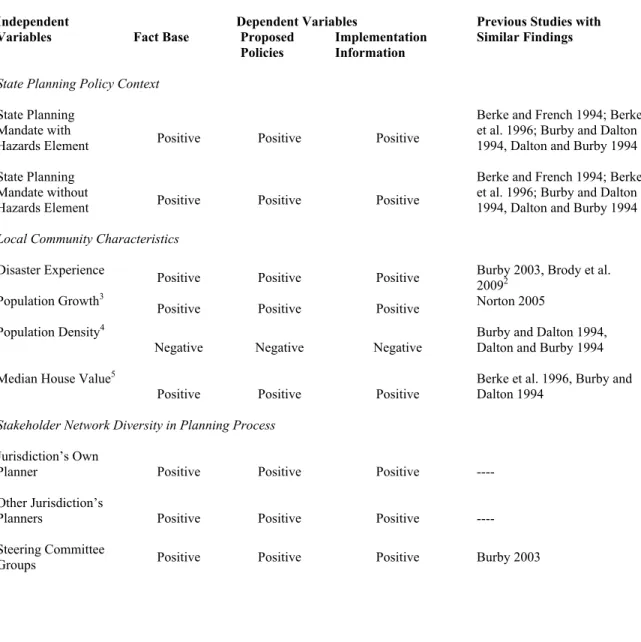
Scholars have examined the influence of three main groups of factors on quality of local
hazard mitigation planning and the incorporation of land use approaches. First, state planning policy
context factors include state mandates for local government planning (Berke and French 1994, Berke
et al. 1996, Burby and May 1997) and state approaches to intergovernmental enforcement of
mandates (Burby and May 1997, Deyle and Smith 1998). Second, local community characteristics
include hazard events that create a ‘window of opportunity’ to focus on mitigation (Birkland 1997,
2006, Brody 2009), local political commitment (Prater and Lindell 2000), and socio-economic
characteristics and growth pressures (Burby and May 1994, Berke et al. 1996, Brody 2003). Third,
characteristics of the planning processes used to develop plans include the diversity of stakeholders
involved and efforts to involve the public (Burby 2003 and Godschalk, Brody and Burby 2003).
The national policy context for mitigation has changed dramatically since most of these
studies were conducted, however. The Disaster Mitigation Act of 2000 (DMA) attempted to move
the country away from its historically reactive and post-disaster federal grant-driven approach to a
more proactive planning-oriented approach (Nolon 2009, Smith 2009). A decade after its passage is
an opportune time for policy evaluation research to determine whether findings from pre-DMA
studies continue to be relevant. Additionally, the existing literature has paid limited attention to the
roles of local planners in mitigation planning processes that are typically led by emergency
management professionals (Kartez and Faupel 1994, Godschalk 2010, Schwab 2010). Even less
attention has been paid to how local planners, emergency managers and other stakeholders work
together as an interconnected network. Filling these knowledge gaps is the major purpose of this
dissertation. Its findings will contribute to theoretical understanding the influence of local planners
and stakeholder networks in planning processes and provide practical knowledge of factors that can
lead to more integration of land use approaches into hazard mitigation efforts.
1.2. Hazard Mitigation: A Critical Phase of the Disaster Management Cycle
The standard conceptual model of the cycle of disaster management activities to reduce
!
$!
Brower and Beatley 1989, Godschalk et al. 1999). The preparedness phase primarily deals short-term
activities in the period leading up to an expected hazard event (e.g. distributing warning information,
evacuating people and pets, and boarding up buildings). The response phase primarily deals with
short-term assistance and aid in the period immediately after the event (e.g. search and rescue, debris
removal, and restoring basic utility services). Both phases are primarily focused on the short-term
safety of people and typically garner the most public attention. Over the last century advances in
managing preparedness and response efforts and increased improvements in weather forecasting have
led to a downward trend in the loss of life associated with natural hazard events in the United States
(Cutter 2001), with the exception of a few major events such as Hurricane Katrina. The success in
reducing disaster deaths and injuries stands in stark contrast to the perpetual increases in economic
losses described above.
Mitigation offers the primary avenue to counter the trend of economic losses because it is the
only phase of the disaster management cycle undertaken well in advance of hazard events (Godschalk
et al. 1999). The mitigation and recovery phases of the cycle share a long-term focus on the physical
development, or re-development, of a community, but the important distinction is that recovery
actions take place in the wake of a disaster event and are fundamentally reactive, whereas mitigation
actions can be taken at any time (Godschalk, Brower, and Beatley 1989, Godschalk et al. 1999).1 A
recent study of mitigation costs and benefits between 1993 and 2003 found that for $3.5 billion in
mitigation investments, $14 billion in benefits have been realized, resulting in an overall benefit-cost
ratio of 4:1 (Multihazard Mitigation Council 2005). The study assessed benefits from project grants
that make capital investments in physical structures and process grants in human, social, and
institutional capital (including action plans and development of codes and regulations) (Godschalk et
al. 2009). The findings indicate that for every dollar invested in process grants the benefit-cost ratio
is 1.3 for floods, 1.7 for wind, and 2.5 for earthquakes, although techniques for assessing benefits
!!!!!!!!!!!!!!!!!!!!!!!!!!!!!!!!!!!!!!!!!!!!!!!!!!!!!!!!
!
%!
from process grants are less developed and may explain the lower ratios than for project grants, which
range from 1.4 (earthquake) to 5.1 (flood).
1.3. Land Use Approaches Can Reduce or Eliminate Hazard Risk
Land use planning (e.g. developing comprehensive plans and administering zoning codes and
subdivision ordinances) focuses on managing the physical development of communities’ public and
private buildings, infrastructure, and natural resources to advance long-term community visions and
goals (Berke, Godschalk and Kaiser 2006). Land use approaches to hazard mitigation reduce or
eliminate hazard risk by directing people and property out of hazardous areas into safer locations
(Godschalk, Brower and Beatley 1989, Burby 1998, Godschalk et al. 1999). They can help preserve
natural features of the landscape that provide mitigation benefits and reduce the need for investment
in costly structural controls (Burby 1998, Olshansky and Kartez 1998, Burby et al. 1999, Godschalk
et al. 1999). Co-benefits for other community goals can also be gained, such as creating greenspace
that serves as a community amenity useful for active and passive recreation (e.g. ball fields and nature
trails). Using land use approaches to reduce risk is not without controversy, though, as evidenced by
the fact prominent supreme court property rights and takings decisions have dealt with land use and
natural hazards (e.g. Lucas v. South Carolina Coastal Council).
Olshansky and Kartez (1998) identify categories of land use management tools useful for
mitigation (Table 1.1). A synthesis of multiple studies from the 1980s and 1990s found that among
the land use approaches that are used to mitigate three types of hazards (floods, hurricanes and
earthquakes) zoning ordinances and subdivision ordinances are most common (Olshansky and Kartez
1998). They also found that many innovative approaches, such acquisition of development rights and
impact taxes, are used infrequently. Altogether, the breadth of the toolkit provides communities
!
&!
Table 1.1. Land Use Policies and Tools and Mitigation Applications Land Use Policy or Tool Mitigation Application
Development Regulations (e.g. zoning ordinances and
subdivision regulations)
Control the location, type and intensity of development, and can be used to direct development away from highly hazardous areas or to limit the amount of assets at risk in marginally hazardous areas
Land and Property Acquisition Purchasing property outright or through easements or development rights to reduce the risk to structures on the property and even return the property to a more natural state with mitigation benefits
Critical and Public Facilities Policies
Regulating the siting of publicly and privately owned facilities critical to community function (e.g. schools, fire departments, power plants) so that they are out of hazardous areas
Taxation and Fiscal Policies (e.g. impact fees or tax breaks for reducing development intensity)
Increase the financial connection for property owners between higher risk development decisions and the public costs the development may incur
Information Dissemination (e.g. real estate disclosure provisions)
Increase public awareness and affect individual and group behavior
1.4. The Federal Hazard Mitigation Policy Context
In 2000, the federal government passed the Disaster Mitigation Act (DMA) requiring all state
and local governments to adopt hazard mitigation plans to be eligible for certain types of federal
mitigation funding. Specifically, the DMA requires local mitigation plans to include four main
components: 1) documentation of the planning process from the creation of the core planning team to
adoption of the plan, 2) a risk assessment, consolidating information about the hazards faced and the
community’s vulnerabilities and risks from those hazards, 3) a mitigation strategy consisting of the
community’s goals and a set of prioritized, future-oriented actions that will be taken to achieve those
goals, and 4) a plan maintenance process that describes how the plan will be monitored, evaluated
and updated (FEMA 2008). Under the DMA and related FEMA implementation guidance, local
governments must update their plans every five years, although local governments may work together
!
'!
action(s). As of 2007, all 50 states and more than 14,000 local governments have adopted hazard
mitigation plans nationally, which constitutes a tremendous investment of time, effort and financial
resources (FEMA 2008 cited in Kang et al. 2010). Presumably, a dramatic increase in local attention
to hazard mitigation compared to the pre-DMA period.
Prior to passage of the DMA, hazard mitigation was fundamentally reactive and driven by
post-disaster mitigation funding because there were no federal requirements for local hazard
mitigation planning and the requirements for state mitigation plans only went into effect after a
disaster event (Godschalk et al. 1999). DMA-compliant planning offers a major opportunity to shift
the approach to mitigation at all government levels to a much more proactive approach driven by the
pre-disaster collaboration of local stakeholders grounded in local risks and goals. Yet, neither the
DMA nor the FEMA requirements require that any particular category of mitigation approachbe
included in a local plan’s strategies. Thus, local governments are under no obligation to attempt to
reduce hazard risks by adopting new land use policies and tools or strengthening existing ones.2
Recent research on the categories of approach most prevalent in DMA-compliant local
mitigation plans for 175 jurisdictions indicates that preventative land use approaches are
comparatively underused, as shown in Figure 1.1. (Lyles, Berke and Smith, 2012). On average, local
mitigation plans include just 10% (1.0 on a 10.0 scale) of the preventative land use approaches
assessed in the study. Further, Figure 1.1. indicates heavy emphasis on emergency services
approaches (e.g. purchasing generators and radios), which directly support disaster preparedness and
response efforts but may do little to reduce long-term risks. This finding suggests there also may be
widespread misconceptions about what types of actions constitute mitigation. These shortcomings in
the implementation of the DMA may be due to which stakeholders are involved in local hazard
mitigation planning and, importantly which are not.
!!!!!!!!!!!!!!!!!!!!!!!!!!!!!!!!!!!!!!!!!!!!!!!!!!!!!!!!
!
(!
Figure 1.1: Actions Included in DMA-Compliant Local Mitigation Plans by FEMA Categories of Approaches
1.5. The Roles of Emergency Managers and Local Planners in Mitigation Stakeholder Networks Local hazard mitigation stakeholder networks consist of the broad range of individuals and
organizations that work together to develop and implement a local hazard mitigation plan. In the late
1990s, Mileti and colleagues emphasized the key role hazard mitigation stakeholder networks play in
harnessing the wide array of information and resources needed to address the evolving challenges of
mitigation (1999). More than a decade later, however, baseline knowledge about who populates
disaster management networks, including hazard mitigation stakeholder networks, is very limited
(National Academy of Sciences 2009). Particularly, there is little understanding of whether the
stakeholders function as a collaborative network sharing information and working together closely
!
)!
how stakeholders share information and work together influence the inclusion of land use approaches
in mitigation plans or success in implementation of specific land use policies or actions.
Disaster management has historically been the responsibility of emergency management
professionals at the federal, state and local levels. The Federal Emergency Management Agency
(FEMA), now within the U.S. Department of Homeland Security (DHS), has national oversight for all
phases of the disaster cycle, including implementation of the DMA. Many states maintain similarly
titled emergency management-oriented agencies or departments. Larger counties and municipalities
often maintain emergency management agencies with dedicated professional staffs, although in
smaller communities emergency management is often one of many responsibilities of an official, such
as fire chief. The profession of emergency management evolved out of a Cold War civil defense
culture and for many years natural hazards were of secondary concern (National Emergency
Management Association 2011.) In their efforts to manage activities related to all phases of the
disaster cycle, many of which center on public safety, emergency managers have not necessarily
received professional training or gained much experience with land use planning and its inherent
focus on long-term patterns of physical development.
Managing physical development of public and private buildings and infrastructure through
land use planning is typically a core responsibility of local planners, but their role in the disaster
management cycle has not been clearly defined. Local planners are municipal, county, and regional
officials with land use orientations by virtue of their educational background, training, agency of
employment, or job responsibilities. Their training includes using the toolkit of land use management
approaches described above to influence the location, types, intensity, design, quality, and timing of
development. Local planners also often bring experience with multiple facets of plan development
and implementation (e.g. facilitating public participation, conducting socio-economic, environmental
and policy analysis, and building consensus on goals and proposed actions) in addition to the specific
!
*+!
For their part, though, planners may fail to see hazard mitigation as part of their area of
responsibility because of a view of it as only a short-term public safety function. Before the DMA
was passed, when mitigation planning was done it was often incorporated into comprehensive plans
developed through planning processes led by local planners. The quality of pre-DMA mitigation
planning was often low to moderate (Berke and French 1994, Berke et al. 1996, Burby and May 1997,
Deyle and Smith 1998, Brody 2003). Burby, May and colleagues found state mandates that building
local capacity and commitment to mitigation were key factors driving the quality of local mitigation
planning (1997). Planning agency commitment was a key factor driving the use of land use
approaches for mitigation. A key concern in the pre-DMA context was motivating local planners
leading comprehensive planning processes to focus more attention on hazards.
While the DMA explicitly requires public participation in the development of hazard
mitigation plans, little is known about who actually participates. In spite of the widespread consensus
on the need to incorporate land use approaches into mitigation, the DMA does not require local
planner participation and until recently FEMA requirements and recommendations for local
mitigation plans did not emphasis planner involvement.3 The lack of incorporation of land use
approaches into hazard mitigation plans shown in Figure 1.1 raises the question of whether local
planners are engaged in hazard mitigation networks at all in many jurisdictions.
Further, even if local planners are involved in mitigation stakeholder networks, the strength
of their relationships with the emergency managers who lead the planning process may be a critical
factor in determining how much consideration land use approaches receive for inclusion in mitigation
plans. Research on relationships between emergency managers and local planners has been sparse.
Nearly 20 years ago, Kartez and Faupel found moderate to low levels of both traditional cooperation
(e.g. participating in a plan development process or in an emergency exercise) and non-traditional
cooperation (e.g. sharing information, special expertise, staff time and other resources). However,
!!!!!!!!!!!!!!!!!!!!!!!!!!!!!!!!!!!!!!!!!!!!!!!!!!!!!!!!
!
**!
when local planners were asked their views on being closely involved in hazard efforts, they indicated
strong support for these types of ways planners can work with emergency managers. Thus, local
planners may represent an under-tapped constituency for hazard mitigation efforts. More recently, a
case study of mitigation planning in Lee County, FL found that strong, long-standing coordination
between planners and emergency managers was a key factor in that county’s successes in integrating
land use and mitigation planning efforts (Godschalk 2010). The experience in Lee County points to
the critical role that bridging the expertise divide between emergency managers and local planners
may play, particularly considering that the public safety director in Lee County has training as a
planner and an emergency manager. The compendium of hazard mitigation best practices by the
American Planning Association in which the Lee County case is included highlights the need for
more integration between emergency managers and local planners (Schwab 2010). Thus, we can
conclude limited collaboration is a little studied ongoing problem that appears to persist as a barrier to
effective hazards management (Schwab 2010).
1.6 Research Questions
The overarching thesis of this dissertation is that the ability of a hazard mitigation stakeholder
network to incorporate land use approaches into mitigation efforts will be affected by the involvement
of local planners, their relationships with emergency managers, and their integration into hazard
mitigation stakeholder network structures. To explore and test this thesis more specifically, two main
research questions are addressed:
1. Does inclusion of local planners in a hazard mitigation stakeholder network lead to greater incorporation of land use approaches in mitigation efforts, when accounting for state planning policy context, local community characteristics, and the diversity of stakeholders involved in the networks?
2. When local planners are included in hazard mitigation stakeholder networks, do differences in how they are involved in the network of the hazard mitigation stakeholders contribute to greater incorporation of land use approaches in mitigation efforts?
This study takes a social network analysis (SNA) approach to understand the role of local planners in
!
*"!
1.7. A Social Network Analysis Approach to Hazard Mitigation Planning
Social network analysis (SNA) approaches explore the attributes of individuals or
organizations that are related to each other (Wasserman and Faust 1994, Knoke and Yang 2008). By
taking a SNA approach, this dissertation breaks new ground in understanding the broad range of
stakeholders engaged in local mitigation, how they work together as a network, and whether
variations in the network from place to place result in the use of more land use approaches to hazard
mitigation. It pursues questions about if and how local planners and emergency managers work
together on mitigation. But it does so in the context of considering the broad range of stakeholders
involved in hazard mitigation, such as other government agencies, elected officials, representatives of
business and non-profit groups, and the general public.
A social network analysis approach enables drawing on a rich theoretical and applied
tradition to analyze two key conceptual dimensions of hazard mitigation stakeholder networks
(Wasserman and Faust 1994, Knoke and Yang 2008, Dempwolf and Lyles 2011). First, SNA
conceptualizes the composition of the network. It starts by considering the diversity of assets
organizations bring to the network. Each organization brings different assets useful to mitigation,
such as information, technical skills, and authorities to administer rules or budgets. These assets
include three types of skills and resources that may be essential for incorporating land use approaches
into mitigation planning: 1) skills and resources related to the mitigation planning process itself (e.g.
facilitation, outreach, communications, mediation, and incorporating the hazard mitigation plan into
other planning initiatives); 2) those related to regulation-based approaches to mitigation (e.g.
developing, administering and modifying development regulations, such as zoning codes and
subdivision ordinances); and 3) those related to project-based approaches to mitigation (e.g.
distributing funds for projects). Assessing the land use-related assets across all the stakeholders in a
hazard mitigation network using SNA enables consideration of whether adequate land use planning
capacity is present in the network and sets the stage for assessing if and how the network is set up to
!
*#!
Second, social network analysis enables conceptualization of the structure of the entire
stakeholder network. It explicitly measures the pattern of relationships between individuals in the
network that shape opportunities to communicate, collaborate and otherwise work together to develop
and implement hazard mitigation plans (Wasserman and Faust 1994, Knoke and Song 2008).
Empirical evidence from fields as diverse as physics, sociology, biology and political science
demonstrate that network structures can vary widely (Wasserman and Faust 1994, Newman 2003,
Jackson 2008, Knoke and Song 2008, Scholz et al. 2008). Network scholars have developed and
continue to refine typologies of categories for different structures and are exploring how variations in
network structure can lead to advantages (or disadvantages) for important mitigation-related tasks
such as sharing information and engaging in joint problem solving (Watts and Strogatz 1998,
Newman 2003, Siegel 2010.). In particular, recent studies have investigated how different structural
attributes of networks influence individual and collective action in the context of estuarine
management, a planning realm that like hazard mitigation involves a wide range of interested
stakeholders grappling with public policy decisions consisting of the interaction of economic, social,
and environmental issues (Schneider et al. 2003, Scholz et al. 2008; Mandarano 2009).
In regards to hazard mitigation stakeholder networks, two organizations are connected to each
other when the organizations share a relationship, such as exchanging hazard-related information used
to write the plan, working together to implement a mitigation initiative included in the plan, or
regularly meeting to monitor overall implementation of the plan. Depending on the frequency and
nature of the connections between two stakeholders, the strength of the relationship can vary.
Depending on how many stakeholders are involved in the network and the number, strength and
patterns of those connections, the structure of hazard mitigation stakeholder networks can vary widely
from county to county. The positions of stakeholders with land use related assets in mitigation
networks with different structures may influence the degree to which other stakeholders in the
network become aware of and choose to prioritize land use approaches to mitigation, although those
!
*$!
A key line of social network analysis research centers on the different effects of small, dense
networks (those networks with lots of redundant connections, or high ‘closure’, within a group of
individuals and few connections outside the group) and large, boundary-spanning networks (those
networks with lots of connections across groups that bridge ‘structural holes’) (Burt 2001). Along
these lines, Schneider and colleagues identify four types of boundaries that can be problematic in
public policy contexts if they are not spanned by a network: horizontal boundaries between adjacent
governments, vertical boundaries between higher and lower levels of governments, expertise
boundaries between professional disciplines, and ideological boundaries between competing interests
(Schneider et al. 2003). The expertise boundary between local planners and emergency managers is a
critical boundary in the context of hazard mitigation planning under the DMA. The following
idealized example illustrates how two different networks structures and related concepts of bridging
and bonding ties may have different advantages and disadvantages. While the examples are
simplistic and somewhat contrived, they are intended to provide a tangible lattice on which more
abstract social network ideas can be overlaid.
First, consider a county facing imminent landfall from a major hurricane. Everyone in the
county may see the emergency management director as the most important person because he or she
has many bridging ties to a diverse array of organizations that can provide valuable information for
protecting public safety. The bridging connections cross governmental and expertise boundaries and
might include NOAA’s hurricane center with its hurricane-track predictions, state emergency
management officials in contact with Governor’s office about emergency responder support, local
public works and utilities officials monitoring on the ground flooding and wind conditions, and so on.
In this situation, a network exists in which a core stakeholder organization (i.e. emergency
management) attracts almost all of the connections in the network, as shown in the ‘star-shaped’
structure in Figure 1.2. This phenomenon, known as preferential attachment, has been observed in
social, physical and a diverse array of other networks (Barbarasi and Albert 1999). Some of the
!
*%!
tight bridging connections. Yet, the other, non-emergency management organizations would not have
strong connections with each other on disaster management issues, which means there are weak
connections across expertise boundaries. This type of network can be very efficient for consolidating
information and, in turn, in distributing that information, as might happen when the emergency
management director authorizes press releases or speaks to the media about voluntary and mandatory
evacuations. More lives may be saved, less time may be wasted sitting in evacuation traffic, and
downed power lines may be fixed more quickly because of the highly centralized and hierarchical
structure of the network.
Now, consider the same county years later in a lull period between major disaster events.
Every year, the network has gotten together occasionally to go through its hurricane preparedness
exercises, receiving updates from the emergency management director about new technologies,
policies, and procedures. The meetings might include group discussion of mitigation projects that
!
*&!
complete beforehand should local elected officials have sufficient funds in their budget. However,
due to the lack of strong, bonding ties between the stakeholders across expertise boundaries
(especially land use and emergency management), the discussion fails to address more sensitive and
challenging topics, such as proposing tighter land use restrictions in the face of political opposition
due to property rights concerns. Afterwards, the stakeholders leave the training exercise and return to
their day-to-day work, considering mitigation in their own organizational stovepipes, if and when
they can include it among their other pressing responsibilities. When the next hurricane hits a few
years down the road the short term response might be very effective due to extremely efficient
information flow, clear procedures, and quick decision making, but the county will likely have
similar, or even higher, levels of property damages and economic disruption than before. Little
progress will have been made in reducing vulnerability by creating patterns of development that avoid
hazardous areas. Clearly, this preferential attachment network structure does not enable the county’s
mitigation stakeholders to meet all challenges with the same effectiveness.
An alternative structure might be more effective for changing physical development patterns
to fundamentally reduce or eliminate risk. Consider a network with a core of multiple stakeholder
organizations with lots of connections to each other and additional connections to clusters of
peripheral stakeholders outside the core, as shown in Figure 1.3. This network might be termed a
‘village’ network with small world characteristics wherein distinct clusters of stakeholders have
bonding connections with each other and bridging connections that link the clusters (Watts and
!
*'!
Such a network might be less efficient in consolidating and distributing information in the
crisis-like preparedness and response phases of a disaster because information is flowing in many
directions at once and there is no central organization responsible for controlling the flow. On the
other hand, this network would allow stakeholders to share, debate and refine ideas together in a
much more free-flowing and flexible manner that enables them to build familiarity and trust over
time. Representatives from a wide array of organizations with very different perspectives and skills
might be better able to tackle the difficult problem of strengthening zoning codes and subdivision
ordinances to prohibit or reduce development in the floodplain. Similarly, together they might devise
a multi-faceted, mutually reinforcing strategy to reduce flood loss in a low-income neighborhood.
They might make a joint application for a grant to purchase and demolish contiguous repetitive flood
loss properties, rezone the property to open space, and return a stream that had previously been
!
*(!
educating the general public about the risks of flooding and the need for stewardship of natural
resources and wise land use. Even if such a project could not be funded immediately, it could be
envisioned and built into strategic open space plans with the aim of connecting the park to a large
network of greenways. Such a project would be emblematic of multi-objective planning that
generates co-benefits, which by definition requires incorporating many perspectives to achieve shared
goals. Without the bonding connections in the inner core of the network complemented by bridging
connections to different types of expertise, such coordination and cooperation seems unlikely. Thus,
there are potential advantages over the more star-shaped network structure.
Importantly, the SNA literature has important ties to theories of the public policy process,
social capital, and communicative planning (Dempwolf and Lyles 2011). For instance,
conceptualizing planning networks as being composed of individuals with a diverse set of assets who
relate to each other through interdependent, or structured, patterns of relationships aligns with
concepts of the role of networks in collaborative planning process in the planning theory literature
(Booher and Innes 2002, Innes and Booher 2010). The specific concepts and theories (e.g. different
structures and bridging/bonding connections), as well as the analytical methods, of social network
analysis lend themselves very well to enhancing our understanding of whether communicative and
collaborative approaches to hazard mitigation planning meet idealized forms in practice (Dempwolf
and Lyles 2011).
Finally, deeper understanding of the stakeholder networks can have practical benefits by
helping local officials responsible for mitigation understand how to better target outreach efforts as
they build their planning teams and involve the public in planning processes. Such understanding
might also give federal and state mitigation officials insights useful for modifying requirements for
local planning processes and for adjusting federal and state support for local mitigation planning
processes. During the research process for this dissertation, FEMA announced its new “Whole
Community” approach, which is very much in line with this argument. The Whole Community
!
*)!
relationships with community leaders, building and maintaining partnerships, and leveraging and
strengthening social infrastructure, networks and assets (FEMA 2011.) Effective implementation of
the Whole Community approach may hinge on network thinking becoming engrained in key
mitigation stakeholders.
1.8. Conclusion
Economic losses from natural hazard events continue to mount and there is reason to expect
even greater losses over time. In spite of widespread consensus about the central role land use
approaches to reduce or eliminate development in hazardous areas should play in hazard mitigation,
land use approaches are under-utilized. While myriad factors contribute to the national failure to
reduce long-term hazard risks more effectively, a key factor that has received limited attention is the
role played by local planners in the networks of local mitigation stakeholders responsible. This
dissertation will examine how local planners who usually bring training and experience needed to
integrate land use approaches into mitigation have been involved to date and what obstacles might
prevent them from becoming more involved in the future.
Failure to further understand the influence of hazard mitigation stakeholder networks will
leave researchers and practitioners blind to a promising way out of a seemingly intractable paradox.
So long as hazard mitigation under the Disaster Mitigation Act is dominated by emergency
management officials trained to focus on short-term preparedness and response activities, those
emergency managers will be forced to try and protect larger and larger numbers of people and
broader and broader swathes of property in hazardous areas as long-term mitigation approaches are
neglected or ignored. Yet, it may be that when local planners are included in hazard mitigation
stakeholder networks and develop close working ties with emergency managers and other
stakeholders, implementation of land use approaches to hazard mitigation may slowly but surely help
stabilize or even reduce the amount of people and property at risk.
Social Network Analysis approaches to understanding hazard mitigation stakeholder
!
"+!
Other major factors have to be considered as well, including the state planning policy context, local
community characteristics and the planning process. These factors likely impact, and may be
impacted by, features of the mitigation stakeholder network. Thus, in the face of the climate change,
it is important to develop a better understanding of whether concerted efforts to foster the
development of local hazard mitigation stakeholder networks results in the greater incorporation of
land use planning approaches into mitigation efforts.
This dissertation is structured as follows. Chapter 1 has established the motivating problem,
identified the research questions, and outlined the research approach that will be taken. Chapter 2
provides the theoretical grounding to explain the influence of the networks of stakeholders involved
in hazard mitigation planning processes on land use planning outputs. It draws on the concepts,
theories, and empirical findings from the literature on plan evaluation, collaborative and
communicative planning, social network analysis, and hazard mitigation. Chapter 3 lays out a
conceptual framework that organizes conceptual dimensions according to the relationships that theory
suggest should explain variations in hazard mitigation planning outputs. The chapter also details
hypotheses that will be tested and how each of the research questions will be answered. Chapter 4,
explains the research design and methods used to answer the questions, evaluate the hypotheses and
refine the conceptual framework. It describes the two main phases of the study: quantitative
regression modeling and qualitative case studies drawing on plan evaluation, surveys, interviews and
site visits.
Chapter 5 presents the results of regression models used to test the central hypothesis across
three principles of plan quality: fact base, policies, and implementation. Specifying the principles to
the incorporation of land use into hazard mitigation plans indicates that plans are stronger 1) when
there is a detailed assessment of existing land use capabilities in their fact bases, 2) when land use
policies are proposed in the mitigations strategy and 3) when information relevant to implementation
of proposed land use actions is included. Chapter 5 also summarizes the patterns of relationships
!
"*!
quality in order to illustrate which variables consistently predict the incorporation of land use across
principles and which variables do not.
Chapter 6 compares findings across four qualitative case studies of county-level hazard
mitigation in Florida and North Carolina. Supplementary appendices provide detailed summaries of
each of the four cases. Chapter 7 concludes the dissertation by revisiting the hypotheses, stating the
overarching conclusions, and presenting recommendations for future research and policy.
Supplemental information about the research design and methods is provided (Appendix I). The four
case studies are Brevard County, FL (Appendix II), Martin County, FL (Appendix III), Onslow
County, NC (Appendix IV), and New Hanover County, NC (Appendix V). Supporting data for the
Chapter 2
Literature Review
2.1 Introduction
The purpose of this chapter is to provide the theoretical grounding to explain the influence of local planner involvement in hazard mitigation stakeholder networks on land use planning outputs. Hazard mitigation is a planning and policy domain involving a broad network of stakeholders engaged in decision making related to the intersection of economic, social, and environmental issues on short-term and long-term time scales, all of which involves federal, state and local governments. It provides a rich domain for testing and refining planning and public policy theories, as reflected in the relatively large number of studies that have used it as a test bed to understand topics of wider applicability across other planning and public policy domains. These topics have included inter-governmental approaches to planning (e.g. Berke and French 1994, Deyle and Smith 1998, Godschalk et al. 1999, and Berke, Lyles and Smith www.ie.unc.edu/cscd/publications.cfm), public participation (e.g. Godschalk, Brody and Burby 2003), and the role of local politics, organizational capacity, past experience with disasters and other community characteristics in focusing public attention on planning (e.g. Prater and Lindell 2000, Birkland 1997, 2006, and Brody 2009.) Considerably less attention has been paid to if and how the broad network of stakeholders actually work together in planning processes and what impacts those networks have on hazard mitigation efforts.
A few baseline terms used in this dissertation need to be defined: planning outcomes,
!
"#!
conditions of importance to a community, such as environmental, social and economic conditions. Planning outputs are the intermediate planning products and actions, such as plans, agreements, and implementation of plan provisions, which in turn generate changes to the underlying conditions and result in planning outcomes. Planning processes are coordinated activities taken by stakeholders to develop and implement the planning outputs to achieve desired planning outcomes. In this
dissertation, planning processes are the efforts of local stakeholders to develop and implement Disaster Mitigation Act-compliant hazard mitigation plans; the planning outputs are the land use-related content of the hazard mitigation plans and implementation of land use-use-related mitigation actions; and the planning outcomes are the sustainability and resilience of the communities engaged in hazard mitigation efforts. Resilience refers to the ability of the social, economic and environmental systems to absorb the impacts of natural hazard events and recover quickly using adaptive strategies (Peacock et al. 2008), while sustainability refers to communities’ abilities to balance the social, economic and environmental needs of current and future generations in the face of hazard stresses (Godschalk et al. 1999).
The remainder of this chapter unfolds as follows. Section 2.2 outlines two key planning outputs: the quality of plans and the implementation of future-oriented aspects of those plans. Section 2.3 introduces key theories and concepts of social network analysis and their applicability in
increasing understanding of planning processes. Section 2.4 lays out the connections between the first two sections in the hazard mitigation context. It reviews the prior literature on drivers of hazard mitigation planning outputs. It also explores how a social network analysis approach can help refine existing understanding of the factors that drive the quality and implementation of hazard mitigation plans. These three sections set the stage for the conceptual framework laid out in Chapter 3.
2.2. Planning Outputs
!
"$!
A rich line of theory and research for planning scholars has sought to address this challenge by identifying, describing, and explaining why different outputs of planning processes matter. By focusing on planners’ fundamental interest in the most obvious output of planning processes – the plan – Baer implicitly anticipates Neuman’s affirmative answer to the question ‘Does planning need the plan?’ (Baer 1997, Neuman 1998).
Plans can embody different concepts, which Baer categorizes as visions, blueprints, land use guides, remedies for specific problems, administrative requirements for federal funds, pragmatic actions, and responses to federal and state mandates (1997). Baer also acknowledges a process-centered view of plans. Hopkins, meanwhile, offers a narrower range of types of plan concepts based on how the plans are used, including plans as an agenda of things to do, a policy serving as an if-then rule, a vision of what could be, a design of a fully worked out outcome, and a strategy laying out considerations that will be taken into account as decision-situations that may be contingent upon one another are encountered (2001). A single plan may fit more than one concept simultaneously, depending on the circumstances of its development and the perspective of those evaluating the plan. This potential for a plan to address different, or even multiple, concepts should be considered by those who evaluate plans because the standards of evaluation may need to vary based on the concept and purpose of the plan.
!
"%!
evaluations of if and how a plan is implemented. 1 Talen and Hopkins offer similar though not identical typologies of plan evaluation.2 This dissertation focuses on Baer’s third and fourth types of evaluation: evaluation of the content of the plan (referred to here as plan quality evaluation) and evaluation of if and how the plan is implemented (referred to here as plan implementation evaluation).
2.2.a Plan Quality Evaluation
The plan quality evaluation approach has been used to describe planning outputs and, to varying degrees, empirically test both the influences on and the influences of specific outputs (Baer 1997 and Berke and Godschalk 2009). It is the oldest and arguably the most prevalent and
methodologically thorough of the plan evaluation approaches (Baer 1997). Studies adopting this approach focus on the quality of plans; that is, the quality of the words, charts, tables, maps and other content in the paper or digital plan document (Baer 1997, Berke and Godschalk 2009). They treat the plan itself or the jurisdiction that adopts the plan as the unit of analysis. The plan quality approach has evolved since the 1970s and has seen increasing agreement among scholars on the core theoretical principles of quality and the content analysis methods to measure quality (Baer 1997, Berke and Godschalk 2009, Berke, Smith and Lyles 2012).
Plan quality researchers continually strive to identify more clearly the constructs about which they wish to make judgments or distinctions about a plan’s content. Scholars have proposed a wide variety of criteria for evaluating different components of plans based on varied conceptual dimensions
!!!!!!!!!!!!!!!!!!!!!!!!!!!!!!!!!!!!!!!!!!!!!!!!!!!!!!!!
1 He also includes plan assessment, but does not include a description of this approach.
2 Talen categorizes evaluation into four main approaches. First is evaluation prior to plan implementation, including evaluation of alternative plans and analysis of planning documents.
Second is evaluation of planning practice, including studies of planning behavior and descriptions of the impacts of planning and plans. Third is policy implementation analysis. Fourth is evaluation of the
!
"&!
of interest and the specific context of the plans being studied (Baer 1997, Berke, Godschalk and Kaiser 2006, Berke and Godschalk 2009). A degree of consensus has emerged about key first-order characteristics, or principles, which can be used to represent multiple conceptual dimensions of plan quality. These principles are considered to be universal and can be applied across multiple contextual domains (e.g. comprehensive planning, transportation planning, hazard mitigation planning, etc.). Some studies have combined these principles to provide an assessment of overall plan quality (e.g. Berke et al. 1996, Brody 2003).
A recently proposed intuitive categorization of these principles distinguishes between
direction setting principles and action-oriented principles, as shown in Table 2.1 (Berke, Smith, Lyles and Reynolds 2011). Direction setting is understood to provide the normative and factual basis for plan making, monitoring and evaluation (modified from Berke, Godschalk and Kaiser 2006). Action-oriented principles relate to the individual and collective actions taken to develop, implement, monitor, and update the plan. While conceptually distinct, the principles are interdependent and an effective plan will be strong on each principle (Berke, Smith and Lyles 2012). Failure to adequately address one or more principles can undermine a plan that has high quality otherwise.
Table 2.1: Direction Setting and Action Oriented Plan Quality Principles
Direction Setting Plan Quality Principles Action Oriented Plan Quality Principles
Vision and Goals Fact Base
Policies (proposed actions)
Implementation
Inter-organizational coordination Participation
Monitoring