Bulletin of the Geological Society of Greece
Vol. 47, 2013
Rockfall hazard in Greece.
Saroglou H.
National Technical University
of Athens, School of Civil
Engineering, Department of
Geotechnics
https://doi.org/10.12681/bgsg.10982
Copyright © 2016 H. Saroglou
Δελτίο της Ελληνικής Γεωλογικής Εταιρίας, τομ. XLVII , 2013 Πρακτικά 13ου Διεθνούς Συνεδρίου, Χανιά, Σεπτ. 2013
Bulletin of the Geological Society of Greece, vol. XLVII 2013 Proceedings of the 13th International Congress, Chania, Sept. 2013
ROCKFALL HAZARD IN GREECE
Saroglou H
1.
1 National Technical University of Athens, School of Civil Engineering, Department of
Geotechnics, [email protected]
Abstract
The geological structure of Greece (frequent occurrence of rock formations, exist-ence of faults and fracturing of rocks), the steep topography and mountainous ter-rain as well as its high seismicity, creates a significant rockfall hazard. During the last decades, rockfalls in Greece are becoming a frequent phenomenon due to the increase of intense rainfall events but also due to the extension of human activities in mountainous areas.
The paper presents rockfall hazard in Greece trough an inventory of rockfalls and investigates the correlation of specific factors, namely: a) triggering mechanism (rainfall, seismicity), b) slope angle, c) lithology, d) fault presence, e) block size on the probability of occurrence of these, based on a statistical approach. The time and space frequency of the events is also investigated. Finally, the impact of the events on human and infrastructures (transportation infrastructure, inhabited areas, ar-chaeological sites) is discussed.
Key words: Earthquake, slope, rainfall, risk, impact.
Περίληψη Η γεωλογική δομή της Ελλάδας (συχνή εμφάνιση βραχωδών σχηματισμών, παρουσία ρηγμάτων και κερματισμός των πετρωμάτων) σε συνδυασμό με το απότομο και ορεινό ανάγλυφο καθώς και την υψηλή σεισμικότητα, συμβάλλουν στην υψηλή διακινδύνευση έναντι καταπτώσεων βράχων. Τις τελευταίες δεκαετίες, οι καταπτώσεις βράχων είναι συχνό φαινόμενο στον Ελλαδικό χώρο εξαιτίας της αύξησης των ακραίων βροχοπτώ-σεων καθώς και τις επέκτασης της ανθρώπινης δραστηριότητας. Το άρθρο παρουσιάζει την διακινδύνευση έναντι καταπτώσεων στην Ελλάδα με τη χρήση μιας βάσης δεδομένων και προσδιορίζει τη σχέση συγκεκριμένων παραμέτρων, όπως: α) μηχανισμός γένεσης (βροχόπτωση, σεισμός), β) κλίση πλαγιάς, γ) λιθολογία, δ) παρουσία ρήγματος, ε) μέγεθος πίπτωντων τεμαχών με την πιθανότητα εκδήλωσης αυτών με χρήση στατιστικής προσέγγισης. Διερευνάται επίσης η χρονική και χωρική συχνότητα και τέλος η επίπτωση των καταπτώσεων στις ανθρώπινες δραστηριότητες (δρόμους, κατοικημένες περιοχές, αρχαιολογικοί χώροι). Λέξεις κλειδιά:Καταπτώσεις βράχων, σεισμικότητα, διακινδύνευση, βροχοπτώσεις.
1.
Introduction
Rockfalls occur when a mass of rock is detached from bedrock and moves downward. They pose significant hazard on human activities and infrastructure. The assessment of rockfall risks along roads and on other human activities is of great importance. Rockfall intensity increases during
periods of low temperature and high rainfall. Geological assessment can lead to accurate prediction of the outbreak of such events, explain its mechanism of occurrence and assist in the effective design of protection measures. Koukis et. al. (1997) note that slope movements, which occur in the form of rockfalls have a relatively high frequency in Greece. The geological structure of Greece (frequent occurrence of rock formations, existence of faults and fracturing of rocks), the steep topography and mountainous terrain as well as its high seismicity, creates a significant rockfall hazard. The rockfall hazard poses a high to very high risk to transportation infrastructure (Highways and railways), domestic areas, archaeological and national heritage sites (ancient monuments, castles, etc.).
During the period 2000-2010, an increase in the number of rockfalls was noticed in Greece, due to intense rainfall events and earthquakes. A significant number of sites, prone to rockfalls, are known along the transportation infrastructure of Greece, near inhabited areas and archaelogical sites. Rockfall protection measures have been applied in relatively few places along highways and other sites in Greece.
The major rockfall at Tempi valley in 2009, led to a loss of human life death and the closure of a section of the Athens-Thessaloniki national road for several months. Other rockfall events, which have also led to human life loss, are those in Kakia Scala (2010), Santorini (2011) and Kefalari, Argos (2012).
2.
Rockfall Inventory
2.1.
Recorded Data
The case studies that were recorded are those, which have occurred as distinct rockfall episodes in natural slopes mainly and have impacted human activities, such as roads, inhabited areas and archaeological sites. Rockfalls, which occur from the road cut slopes along highways in the national road network, were not recorded in the present study. These are very often and especially encountered in Pindos mountain range but also in other mountainous areas. Some rockfalls on highways are
The following data were recorded for each rockfall episode: a) Location, b) Coordinates, Altitude, c) Type of site (roadway, inhabited area, archaeological site), d) Date (s) of rockfall events, d) Triggering mechanism (rainfall, earthquake, other), e) Fault scarp presence, f) Geological formation, g) Rock mass type, degree of fracturing, h) Slope height, i) Slope angle, j) Block size of fallen blocks, k) Impact type, l) Presence of vegetation (forest etc.), m) Energy level, n) Reference. The recorded rockfalls are fifty-six events for the period between 1935 and 2013. The locations of these are presented in Figure 1. Additionally, the most important parameters of these events are given in Table 1.
It is evident that the frequency of rockfalls has increased significantly in the period between 2000 and 2010. This can be attributed to the increase of intense rainfall periods but also to the extension of human activities (infrastructure, increase of population etc.). In a number of sites, more than one event has occurred and thus it is possible to predict the return period of the phenomenon.
Koukis & Ziourkas (1991) and Koukis et. al. (2005) presented a landside frequency zone map for Greece. The relative frequency of rockfalls in these maps was 11 %. The maximum frequency of landslides in those maps, expressed in cases per surface area, is along the Pindos geotectonic zone,. Based on the present study, this maximum does not also depict the maximum frequency of rockfalls as it mainly reflects the large number of slope instabilities occurring in the flysch formation in the form of soil type or composite failures (rotational, translational etc.).
Rockfalls in Greece are more frequent in mountainous areas at slopes with angles greater than 50 degrees, as it can be seen by the concentration of events in Pindos Mt., Tempi valley and
Parnassos Mt., shown in Figure 1. Rockfalls also occur in low to medium altitude areas but with steep slope morphology, usually related to fault scarps, as it the case in Kakia Scala, Klokova, Monemvasia and elsewhere.
Figure 1 - Location of recorded rockfalls.
2.2.
Time – space Frequency of Rockfalls
Based on the recorded data it was possible to define the frequency of rockfalls during the studied period. The frequency of rockfalls is shown in Figure 2.
1920 1930 1940 1950 1960 1970 1980 1990 2000 2010 2020 2030 Time Period 0 2 4 6 8 10 12 14 16 18 20 Fr eq ue nc y N 1 3 4 3 4 5 16 5
Table 1 – Main data of recorded rockfalls in Greece.
Id Location Type Date Trigger Rock
type scarp Fault Block (m3) Imp-act Ref.
1 Tembi Valley R 17/12/2009 2004,19771 ND M 0.5 – 5, 502 HLL, RC R1, R2 2 Eptachori, Kastoria D 1935, 51, 68, 70,87, 93, 94 R M Y 3363 DH R3, R4 3 Konitsa,Ioaninna D/A 8/1998 E LA 2 DH R5 4 Orliagas, Ziakas D/R ND L Y 1 ND R6 5 Pramanta -Ioannina R 9/3/2004 ND L Y < 1 DR
6 Nea Pefki, Trikala R 20/10/2010 R S < 1 DR
7 Drimonas,Lefkada D/R 14/8/2003 E (6.4) L Y < 1 DR R7
8 Lefkada,Ag.Nikitas D/R 14/8/2003 E (6.4) L Y 13.7 PDR
9 Kamena Vourla D 27/8/2012 ND L 1 DH
10 Tithorea, Parnassos D 19/12/2010 1999, 1957 ND L 10 DH R8
11 Delfi ancient site A 2003, 091 R L 8 V R9, R10
12 Vageni Distomo D/R ND C Y 40 PDR R11 13 Klokova Mt. R 16/11/2012 ND L 1-2 DR 14 Itea, Monastiraki R 18/1/2010 E (5.1) L Y <1 DR 15 Geraneia Mt. 24/2/1981 E (6.3) L Y R12 16 Kakia Scala R 20/11/2000 R L Y 0.5 HLL 17 Vouliagmeni,Attica D 1/1982 ND L Y 1-2 R13
18 Oksilithos, Paralia-Platana R 13/8/2008 ND MS 1.5 HI R14
19 Skyros Island A 26/7/2001 E (5.8) L Y 1-2 DC R15 20 Mythimna, Lesvos A 2001 R A 0.3 ND R16 21 Stypsi, Lesvos D 1963, 1977 R A 0.5-3.0 DH R17,R18, R19 22 Taxiarches, Lesvos D 1963, 3/11/09 ND M Y 1 DH R20 23 Santomeri, Achaia D 8/6/2008 E (6.5) L Y 4 DH R21 24 Anc. Olympia R 22/1/2013 R L 0.5 DR 25 Argos Castle A 1987 ND L D R22 26 Kefalari, Argos D 20/4/2012 ND L Y 0.1 HLL R23 27 Acronafplia A 1/2010 ND L 0.5 V R24
28 Ladas, Eleochori, Poliani, Kalamata D 13/9/1986 E (6.2) L <1 PDH R25
29 Leonidio, Tiros R 6/1/2008 E L Y <1 RC
30 Molaoi, Lakonia D 2/2003 R CA 1-2 PDH R26
Id Location Type Date Trigger Rock
type scarp Fault Block (m3) Imp-act Ref.
32 Therma Ikaria D 10/1978 ND M Y 1 PDH R28 33 Kalymnos D 12/2002 R L 4 PDH R29 34 Chora, Ios D - ND S 1 PDH R30 35 Santorini D 2011 R P 0.5 HLL 36 Carpathos,Akropoli D - ND L - R32 37 Topolia, Chania R 23/2/2012 R L Y 0.5 FB 38 Kourtaliotis gorge R 4/3/2012 R L Y 1 DR
39 Heraklion (Pitsid-ia,Akoumia) D 14/5/1959 E (6.3) L Y <1 DH R12
40 Ag. Fotia, Crete R - ND S <1 DR
1More rockfall events exist, which are not presented here, 2 A record of fallen blocks is given in Gazetas et.
al. (2010), 3the largest rock block, 15 smaller rocks have fallen in this site, Type: R=Roadway, D=Domestic,
A: Archeological, Trigger: R=rainfall, E=Earthquake, ND=Not defined, Rock type: L= limestone, M=marble, CA= Calcitic agglomerate, LA=Limestone agglomerate, C= conglomerates, S=sandstone, M=marls, MS= marls/ sandstones, SG=Schist/gneiss, A= Andesite, P= Pyroclastics, Fault Scarp: Y=yes, Impact: HLL= Human loss, HI=Human injury, V=Potential impact on visitors, damage to archaeological site, DH=Damage to houses, PDH=Potential house damage, RC=Roadway closure, DR=Damage on roadway, PDR=Potential roadway damage, FB=fall on moving bus, DC=Damage on cars, ND= No damage. R1=IGME (1979), R2 Gazetas et. al. (2010), R3=IGME (1989), R4= Emmanouloudis & Filippidis (2000), R5= IGME (1998), R6= Papathanassiou et. al. (2010), R7= Vogiatzis et. al. (2004), R8= Papathanasiou et al. (2011), R9=Christaras & Vouvalidis (2010), R10=Marinos & Rondoyianni (2005), R11=IGME (2003), R12= Papazachos &Papazachou 1997, R13=IGME (1982), R14=Velissariou (2008), R15=Marinos & Tsiambaos (2002), R16=Marinos et. al. (2001), R17=Pangaea (1995), R18=IGME (2002), R19=Saroglou (2012), R20=Tsiambaos (2010), R21=Lainas et.al. (2010), R22=Sofianos et. al. (1988), R23=Kampouroglou & Chatzitheodorou (2012), R24=Konstantopoulou et. al. (2011), R25=Mariolakos et. al., (1987), R26= IGME (2003), R27=Saroglou et. al. (2012), R28= IGME (1979), R29= IGME (2003), R30=IGME (2002), R31=Antoniou, Lekkas (2010), R32=IGME (2003).
2.3.
Triggering Mechanisms
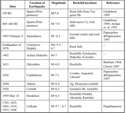
The main triggering mechanism of rockfalls in Greece is rainfall. 13 rockfall events where triggered by rainfalls (frequency equal to 33%) and 1 event by a snowfall. A rise in rockfalls has occurred during the last years (2010 - 2013) due to heavy rainfall in limited time period usually during winter. Eighty six (86) instability phenomena were reported in 2010, from which 5% were rockfalls (Nikolaou et. al., 2011). The triggering factor of 95 % of those was intense rainfalls during February and November-December period. Additionally, the most affected area was Epirus Prefecture. Krautblatter & Moser (2009) proposed a model coupling rockfall and rainfall intensity. The second most important triggering mechanism is seismic loading during earthquakes since 10 events by seismic loading (frequency equal to 25%). The rockfalls triggered by historical earthquakes in Greece, which are reported in literature (by Pavlides & Caputo, 2004, Ambraseys & Jackson, 1990), are summarized in Table 2. Recent earthquakes which have triggered large rockfall events are those in Skyros (2001), Lefkada (2003), Achaia (2008) and older events those during Alkyonides (1981) and Kalamata (1986) earthquakes. During Kalamata earthquake rockfalls occurred in the villages of Poliani, Eleochori and along the road linking Kalamata with Sparti (Papazachos & Papazachou, 1997). The rockfalls occurred along reactivated fault scarps (Mariolakos et. al., 1987). In some events the triggering mechanism was not defined.
Table 2 –Rockfalls during historical earthquakes.
Date Earthquake Location of Magnitude Rockfall locations Reference
550 BC Sparta (Pelo-ponnese) Mi7.0 Rock falls from Tay-getus Mt Guidoboni 1989 469–464 BC Sparta (Pelo-ponnese) M>7.0 fault traces (?), rock falls Guidoboni 1989, Armijo
et. al. 1991 1893 February 9 Samothrace M= 6.5 Ground cracks and rock falls Papazachos &Papazachou
1997 Earthquakes of
1870 (Arachova-Delphi) Ms=5.3 -6.7 Rock falls ‘’ 1402 Achaia Diakofto M=7 Rockfalls Xylokastro, Diakofto, Evrostini ‘’
1633 Zakynthos Μ=6.9 Rockfalls Barbiani 1864, Chiotis 1887 1636 Cephallonia Μ=7.1 Livatho, Argostoli, Liksouri Papazachos &Papazachou
1997 1694 Athens Μ=6.4 Ag. Dionysios rockfall 1928 Corinth Μ=6.3 Geraneia Mt. rockfalls 1959 May 14 Heraklion Μ=6.3 Rockfalls Pitsidia, Akoumia, Kamilari 1783, 1825,
1885, 1914,
1915, 1948 Lefkada Μ=5.7 - 6.7 Rockfalls Papathanasiou
2.4.
Impact of Rockfalls
Based on the analysis of the data, the main impact of rockfalls is damage and temporary closure of roadways (frequency equal to 32%) and secondly damage to houses (frequency equal to 20%). The percentage of potential damage to roadways and houses is 5% and 13% respectively. Additionally, the percentage of loss of human life is 11%, which is considered exceptionally high. Furthermore, the frequency of potential impact on visitors and damage to archaeological sites is equal to 11%. According to Nikolaou et. al. (2011), from the 86 instability phenomena (5% rockfalls), which were reported in 2010, 34% of the cases impacted the roadway network and 66% inhabited areas. The most known and studied events, which have occurred along highways and other roads, are that of Tempi (shown in Figure 3a), Kakia Skala and Klokova area. Significant rockfall events impacting roads have taken place in Ag. Nikitas in Lefkada island (Figure 3b), in Oksilithos (Velissariou, 2008), along roads in Kourtaliotis gorge, in Topolia and Ag. Fotia in Crete island. Recent events that affected inhabited areas are those in Eptachori in 1994, in Skyros in 2001 (Marinos & Tsiambaos), Santomeri in 2008 (Lainas et al., 2010) and Tithorea in 2010 (Papathanasiou et. al., 2011), which is presented in Figure 3c. Sites of high risk in inhabited areas need to be identified in order to minimize rockfall risk.
Additionally, there are a large number of rockfall incidents, which have occurred in archaeological and national heritage sites. These pose a significant danger to tourists and visitors as well as they affect the integrity of the monuments itself. Well known example is that of Delfi site (Marinos & Rondoyanni, 2005), where part of the archeological site was closed in 2009. Other studied sites are Mythimna castle (Marinos et. al., 2002), Monemvasia castle (Saroglou et. al., 2012), as presented in Figure 3d and others.
a b
c d
Figure 3 - Impact of rockfall a) on highway in Tempi valley b) on roadway during Lefkada earthquake (photo from Geobrugg), c) Tithorea village, d) Monemvasia archaeological site.
3.
DETERMINANT FACTORS
3.1.
Slope Angle
Generally, Rockfalls occur at slopes with an inclination greater than 45 degrees. In the studied areas the slope angle ranged between 45 and 90 degrees with a mean value of 70 degrees.
3.2.
Lithology – Degree of Fracturing
The most frequent geological formation encountered in the study areas, is limestone (with a frequency equal to 64%). The percentage of occurrence of the rocks forming the studied slopes is presented in Figure 4a. Generally, limestones are found broken to heavily broken, especially when in the vicinity of faults, resulting in blocky rock masses. Rockfalls are favoured in blocky or very blocky rock masses, since medium to large rock blocks are formed by intersecting discontinuities and can be relatively easily detached by the action of water or seismic loading.
In a large number of sites, scree is present at the foot of the slopes. The presence of a scree slope below the rock cliff suggests slope ravelling activity. According to Sartori et al. (2003), this activity can be linked to the progressive failure of the rock cliff, but can also be a precursory event of larger rockfalls. Dorren & Seijmonsbergen (2003) assigned rockfall susceptibility categories to
geological formations according to their nature and ability to produce rocks blocks. They considered limestone to have high susceptibility, while schists, slates, marls and sandstones low to medium. The block size of the fallen blocks ranges between 0.5 m3 and 50 m3 with an exception of
Eptachori rockslide. The blocks size is less than 1m3 in 22 sites and between 1 and 5 m3 in 8 sites,
as presented in Figure 4b. a) 0 5 10 15 20 25 30 35 40 45 50 55 60 65 70 Block size (m3) 0 2 4 6 8 10 12 14 16 18 20 22 24 Fr eq ue nc y N 22 6 2 2 1 1 1 b)
Figure 4 - a) Lithology in areas of rockfall events, b) Frequency of block size of fallen rocks.
3.3.
Presence of Faults
Gallousi & Koukouvelas (2007) have correlated the triggering of the Marathias rockslide in Corinth Gulf with the seismicity of the area. The slide is formed along a fault scarp. In the study areas, twenty (20) slopes are related to the presence of faults and this contributes to the higher rockfall activity.
4.
Conclusions
In the present paper a review of the rockfall activity in Greece was done for the period between 1930 until the present. A rockfall inventory was created, accounting for all the parameters determining the rockfall events. Based on the analysis of the data, it was shown that the number of rockfalls has increased substantially in the recent years. It is also concluded that the main triggering mechanism is rainfall, while a significant number of cases is related to earthquakes. Emphasis was given to the presence of faults and it was shown that almost half of the slopes were formed or relate to faults. In the study areas, limestone formations predominate, while the rock masses are blocky to very blocky resulting in block size range of the fallen block between 0.5 and 5 m2 in the majority of the cases. Finally, the impact is severe in most cases having resulted in
human life loss in four cases and usually in damages to roads and secondarily to houses, as well as potential risk to archaeological sites (visitors and structures).
5.
References
Ambraseys N.N. and Jackson J.A. 1990. Seismicity and associated strain of central Greece be-tween 1890 and 1988, Geophys. J. Int. 101, 663-708.
Antoniou A.A. and Lekkas E. 2010. Rockfall susceptibility map for Athinios port, Santorini is-land, Greece, Geomorphology, 118, 152-166
Armijo R., Lyon-Caen H. and Papanastassiou D. 1991. A possible normal-fault rupture for the 464 BC Sparta earthquake, Nature, 351, 137–139.
Asteriou P., Saroglou H. and Tsiambaos G. 2012. Geotechnical and kinematic parameters affecting the coefficients of restitution for rock fall analysis, Int. Journal of Rock Mechanics and Mining Sciences, Vol. 54, 103-113, ISSN 1365-1609, 10.1016/j.ijrmms.2012.05.029. Christaras B., Filippides A., Vogiatzis D., Kantiranis N., Moraiti E., Dimitriou A. and
Pa-pathanassiou G. 2004. Rock falls and protective measures of the down slope area. The case of Drimon village, in Lefkas island, during the earthquake of 14/8/03 (Ms=6.4), 32 IGC, Florence.
Christaras B. and Vouvalidis K. 2010. Rockfalls in the archaeological site of Delphi, Greece,
Proc. of IAEG 2010 International Congress, Auckland.
Dorren L. and Seijmonsbergen A. 2003. Comparison of three GIS-based models for predicting rockfall runout zones at a regional scale, Geomorphology, vol. 56, (1-2), 49-64.
Emmanouloudis D. and Filippidis E., 2000. Α G.I.S. technique for volume calculation of Eptahori rockfalls, Macedonia, Greece, in Tsihrintzis et. al. (eds), Proc. of Int. Conf.: Protection and Restoration of the Environment V, Vol. I, pp. 429-435.
Gallousi C. and Koukouvelas I. 2007. Quantifying geomorphic evolution of earthquake-triggered landslides and their relation to active normal faults. An example from the Gulf of Corinth, Greece, Tectonophysics, 440, 85–104.
Gazetas G., Kavounidis S., Rozos D. and Tsiambaos G. 2010. Corollary Expert Committee for failures in Tempi, Technical Chamber of Greece (in greek).
Guidoboni, E. (Ed.) 1989. I terremoti prima del Mille in Italia enell’area mediterranea, Instituto Nazionale di Geofisica (ING), Bologna, 765 pp.
Andronopoulos B. and Koukis G. 1979. Geological – geotechnical study of slope stability along the national highway in Tempi area, Unpublished report, I.G.M.E, Athens.
Rozos D. 1979. Geotechnical investigation for slope stability of rockmass in Therma, Ag. Kirikos, Ikaria island, Unpublished report, I.G.M.E, Athens.
Chatzinakos I. 1989. Geotechnical investigation of the slope stability of Eptachori, Kastoria, Un-published report, I.G.M.E, Athens.
Mpellas M. 1998. Geotechnical study for mitigation of detached blocks on slope of Konitsa Mu-nicipality, Ioannina, Unpublished report, I.G.M.E, Athens.
Andronopoulos V. 1982. Preliminary study of geotechnical conditions of the slopes in Vouli-agmeni lake, Unpublished report, I.G.M.E, Athens.
Antonopoulos M. 2003. Engineering geological study report for instability phenomena in Akropoli area, Municipality of Carpathos, Unpublished report, I.G.M.E, Athens.
Rozos D. and Nikolaou N. 2002. Engineering geological investigation of rockfalls in Ios island, Cyclades, Unpublished report, I.G.M.E, Athens.
Pogiatzi E. and Konstantopoulou G. 2003. Engineering geological investigation of rock slopes in Molai, Lakonia, Unpublished report, I.G.M.E, Athens.
Nikolaou N. 2003. Engineering geological investigation of rockfalls in Vageni, Distomo, Voiotia,
Unpublished report, I.G.M.E, Athens.
Apostolidis E. and Aleyras N. 2003. Engineering geological investigation of rockfalls in Kalym-nos, island, Unpublished report, I.G.M.E, Athens.
Apostolidis E. 2002. Engineering Geological investigation of the instability phenomena in Stypsi, Petra prefecture, Lesvos Island,. Unpublished report, 37 pp., I.G.M.E, Athens.
Kampouroglou E. and Chatzitheodorou Th. 2012. Report on the geological, engineering geologi-cal conditions of cave and rock slope in Kefalari, Argos, Ministry of Culture (unpublished). Konstantopoulou G., Spanou N. and Kontogianni V. 2011. Rockfall Susceptibility - Hazard and risk assessment of Akronafplia historical site, Nafplio, Greece, The 2nd World Landslide
Forum Abstracts, WLF2 - 2011– 0300.
Koukis G. and Ziourkas C. 1991. Slope instability phenomena in Greece: A statistical analysis.
Bull. Int. Assoc. Eng. Geology, vol. 43, 47-60.
Koukis G, Tsiambaos G and Sabatakakis N .1997. Landslide movements in Greece: engineering geological characteristics and environmental consequences, in: Proceedings of Internation-al Symposium of Eng. Geol. and the Envar, IAEG, BInternation-alkema, Rotterdam, pp 789–792
Koukis G., Sabatakakis N., Nikolaou N. and Loupasakis C. 2005. Landslide hazard zonation in Greece, in: Sassa K, Fukuoka H, Wang F, Wang G (eds) Proc. 1st General Assembly and
The 4th Session of Board of Representatives of the Int. Consortium on Landslides, pp. 291–
296.
Lainas S., Koulouris S., Vagenas S., Depountis N. ,Sabatakakis N. and Koukis G. 2010. Earth-quake-induced rockfalls in Santomeri Village, Western Greece, Proc. of the 12th Interna-tional Congress, Patras.
Marinos P., Kavvadas M., Tsiambaos G. and Saroglou H. 2002. Rock slope stabilization in Myth-imna castle, Lesvos island, Greece, 1st European conference on landslides, Balkema, Rybar Stemberk & Wagner (eds), Prague, 635-639.
Marinos P, Tsiambaos G. 2002. Earthquake triggering rock falls affecting historic monuments and a traditional settlement in Skyros Island, Greece, Proc. of the Int. Symposium: Landslide risk mitigation and protection of cultural and natural heritage, Kyoto, Japan, pp. 343-346. Marinos P., Kavvadas M., Tsiambaos G. and Saroglou H. 2002. Rock slope stabilization in
Myth-imna castle, Lesvos island, Greece, 1st European Conference on landslides, Balkema publ,
ed: Rybar Stemberk & Wagner, Prague, pp. 635-639.
Marinos P. and Rondoyanni Th. 2005. The archaeological site of Delphi, Greece: a site vulnerable to earthquakes, rockfalls and landslides, Proc. of the 1st General Assembly of the interna-tional consortium on Landslides: Landslides- Risk analysis and sustainable disaster man-agement (2001), Ed. K. Sassa et al., Springer, Kyoto, ch. 31, pp. 241-249.
Mariolakos et. al. 1987. Presentation in Geological Society of Greece workshop.
Nikolaou N., Pogiatzi E. and Spanos N. 2011. Report on landslides in Greece on 2010, I.G.M.E. p.8.
Pangaea Consulting Engineers, 1994. Study for the protection of Stypsi village from rockfalls. Papathanassiou G., Valkaniotis S. and Chatzipetros A. 2010. Rockfall susceptibility zoning and
evaluation of rockfall hazard at the foothill of Orliagas Mountain, Greece, in: Christofides et al. (eds), Proc.of the XIX Congress of them Carpathian-Balkan Geological Association, Special Pub., vol. 99, 165-171.
Papathanasiou G., Marinos V., Vogiatzis D. and Valkaniotis S. 2011. A rock fall analysis study in Parnassos area, Central Greece, Proc. 2nd World Landslide Forum, Rome.
Papazachos B.C. and Papazachou C. 1997. The Earthquakes of Greece, Editions ZITI, Thessaloni-ki, 304 pp.
Pavlides S. and Caputo. 2004. Tectonophysics Magnitude versus fault’s surface parameters: quan-titative relationships from the Aegean Region, Tectonophysics, 380, 3-4, 159-188. Saroglou H., Marinos V., Marinos P. and Tsiambaos G. 2012. Rockfall hazard and risk
assess-ment: an example from the high promontory at the historical site of Monemvasia, Greece,
Nat. Hazards and Earth System Science, Volume 12, Issue 6, 1823-1836.
Saroglou H. 2012. Engineering geological behaviour of volcanic formations. References to insta-bility phenomena and town planning in Lesvos Island, Greece, Bulletin of the Geological Society of Greece, vol. XXXXVI, 90-104
Sartori M., Baillifard F., Jaboyedoff M. and Rouiller J.-D. 2003. Kinematics of the 1991 Randa rockslides (Valais, Switzerland), Natural Hazards and Earth System Sciences, 3.
Sofianos A., Constantinidis C., Christodou-lias J. and Anagnostopoulos A. 1988. Rockfall analysis at the ancient region of Argos, in Engineering Geology of Ancient Works, Monuments and Historical Sites”, Marinos and Koukis (eds.), pp. 213-216, Bal-kema.
Tsiambaos G. 2010. Report for rockfall protection in Taxiarches village, Lesvos (unpublished) Velissariou 2008. Geological report in the rockfall event in Oksilithos, Kymi (unpublished) Vogiatzis D., Dimitriou A., Papathanasiou G., Christaras B., Kantiranis N., Filippidis A. and
Mo-raiti E. 2004. Rockfalls during the earthquake of 14/8/03 and probable solutions at the up-per level of Drimonas village slope, Municipality of Sfakioton, Leukada Island, Bulletin of the Geological Society of Greece, vol. XXXVI, 1735-1742.