General Disclaimer
One or more of the Following Statements may affect this Document
This document has been reproduced from the best copy furnished by the
organizational source. It is being released in the interest of making available as
much information as possible.
This document may contain data, which exceeds the sheet parameters. It was
furnished in this condition by the organizational source and is the best copy
available.
This document may contain tone-on-tone or color graphs, charts and/or pictures,
which have been reproduced in black and white.
This document is paginated as submitted by the original source.
Portions of this document are not fully legible due to the historical nature of some
of the material. However, it is the best reproduction available from the original
submission.
Produced by the NASA Center for Aerospace Information (CASI)
YA
SIGNIFICANCE OF DUAL POLARIZED LONG WAVELENGTH
RADAR FOR TERRAIN ANALYSIS
('I A` , A-CR-157947) SIGNIFICANCE of DUAL N79-12260
B)LARIZED LONG WAVELENGTH RADAR FOR TERRAIN
A II ^LY5I5 (Arkansas Univ.) 19 p NC A02/MF
" D1 CSCL 171 Unclas G3/32 37560 By H. C. MacDonald W. P. Waite October 1970 JPL Contract No. 954940 University of Arkansas Fayetteville, Arkansas
This work was performed for the Jet Propulsion Laboratory, California Institute of Technology,
sponsored by the National Aeronautics and Space Administration under Contract
NAS7-100 (lask Order No. RD-105),
ps
11111w* '` • I
Ihi, rr;alrt cont .1Ill% ill tbrmat IItI% ;+►'rlt,lrt"I by ttitt till iver%ity at +<II'Ii,111%A\ tillde1, ,,lit %W% l illllro, t , It \ cwltellt I . -lit It it titv %'Iri l / ttlltttll'slid t►,1 tItit
Ovt N►',Il %kiI%itill Iat+t1 I'll tt►ry, t'al i it, I'll i,t Iit`.t itittI it I tit, 111wIOi1v, i+r thlt N,it iotial Altlr'naut it % anti Shirt- Atimini`.trat loll.
.AllsI RACI
1 hl` tit at t itl'od I,vtlirll 1'1'1 tit, kit, it t'\ 1111,1+1111,) 1'ii till r . i1 11rIl1w.lI-Ii 1'
`.1'11 . i t 1 \ I . ti t t .11'i)1`t %t l'IIrI tllT i t 1' 11i11,)h I lt allti k kim +i+., i t It'll t'1' t 0111111 t`\ pet-111iIt 1vit%. It t' re .1t i\t t til l it N l i t , It1 1 tl'at ittll 11 1' It do11t11 it 111,1tt'ria)
it whi,h tht` rtiturn 1
%1.11%1t i\I, aI%o %ill.IIt% kit rc'rtly with ttitt Not NInil h.11 vi r ll.)t It , lit+%t itIl%i% a11 o ra,lar Iill.%k1t'1't 111Yt►i 1'•.". All at tofil't tit X1. 1"1 ra I t t t lt,tll.)c`% ,lilt" t 0 rtltl,lhntl%% .Ilia pe Til l t t 1 \' i t 1 ,l ilt) t it `.1'Ila rat r
11tU.j1111c t .^ IIItti \'rt11'tat it'll 11111) 111-mill t (\'I-IUme Ur surtart' tirdtter) (t1mpollt'llts. UItt'rt' It t',,<'t lit ittll , All tit' ill 1111111.1; t t .t a rA1'tor tilt` uI, rat t' ret tll'll It all tit` ,Allah:"" 1,11, varl.1tioll`. ill r►Iu , ill 1111.`• it 1, cuml'it,itit'n (I1rIIlm1,ily Ilk, i%titre toittt'it' + Itilltj 1t,1\'ttttill i)tit %).%tow., witit Inprllvtill 11t'llt'tl'at1011 1,al4lhiI itl"
(1,1\It I,'1,) tirrll r0INitlt`l'Ittl to ItIIttt ttlt- Ihlt till :ial tit ill iitl Ill i:iIIki ttlt- ! Vtttic`t,l: 1,111 tiintl'i Oil t Iitii .1itd 1.1111.111, 1111) tilt` S kit' i ilk tt Ill- ttll • 11 vitriat it'tt'.
I ti,l'1,' t.", t '1 kill \tti till i1t111 1 I'm lit- r %Ii ttit- Arkall`.a`. i1tt,+I kill i1 tvst %i tt`
Itl','\ I . It'll{iromtor\ I'\ 1111`11, t' i+t tIII it( iI,% t . 110ht`\t•1•t t Ill, illrrt',1 .t`,1
IV.1\t•1t't,1t11 1 Ilk IT.1`.I`. tilt` `• I'll NitIItIt\ t0 iitV%l( t 1' \1,111' Ntl'llrtlll't' ,It I - VI Ativt- IY
\Ii1,1ii Iltritit`llrtt .l ittllr•. IIty rtitjtliarIt) it at)I.IritItwraI ,11111 kiO'.111 tirrtlltt. ' lirt'\ i il;". 1.11',;1` 1 tt"lt.+lit'l1I \ 111 t It It i ow 11'1`,Itlt'11t 1 1 .11',11' `.t AI r 'soft 11111 it t t tit` 1 1\1WkIll11 `,I+t', trom that are ItI till '' %tilltiit i\t. ti+ it till t,lt IitIt. 1t11t ait,lit Iitlt
til A t i',i'•,• IY IaI , 1: Il l ,1 r11.111nt'i I% `.II 1 %v II t,+ on ' a l it" tilt' Iittt`I'I t l't t tI , I' tit d I % t i1 1. ;•I) ,h \t`,)rtitI Ikill Anil itril -it 1.1t i►'11,1) l i t' 1 , ttl0 1 ,1t it'll `• III 1111` %urta,'tt
s Il{ ^ nay 111 ';i + ^. s " . . t ^ ^ (. LI Iy 11} 111+ 1 q
New Technology None ^s
I N'TRUUUGTI ON
Thu Landsat and Skylab programs have vividly demonstrated the ^r
utility of spacecraft data for earth resource applications. These
applications include mineral and petroleum exploration, agricultural and i
natural vegotation discrimination, land use anilandfarm classification
and it host of others (Matthews,
19711). Arecurront theme in the reports
of these applications is the necessity of timaly
dataacquisition and the
zdesire
for it taeasnrement paramater responsive to moistu re.
Radar has
r
J
long been proposed as the logical extension of the currant orbital vomot:c
sensing capability. The frequency range and active made of operation of
radar provide the desired day-night all-weather sensing capability. This
w
;t
oparntionitl advantage coupled with the capability nP rapid data
+_
acquisition has led to extensivo use of airborne radar as a substitute
r .
Ifor photography, particularly in vemnto and cloud-shrouded regions of the
world. This type of application involves int:erpretat:ion of the scone
goometry as transformed by the imago system, Discrimination of areas and
regions is utilized, but little identification is attempted by other
than heuristic methods, Virtually all commercial uses of radar are
based on operational convenience and the advantage afforded by having
solectable angles of incidence and orienLntinn to enhance terrain
:shadowing.
for
Several years, resonrehers in radar remote Sensing have att:emptod
to idrnt:ify specifie applications that make use of the unique information
contained in the scattered return produced as a result of
the
the terrain-sensor
interaction, Brie , ly stated, the unique features of the radar return are
4 a sensitivity to roughness (structure) at the wavelength scale, a
sensitivity to moisture content. (composition) caused by the relatively
1 high permittivity of water, and the ability at lower frequencies to
penetrate a significant depth of material. Applications development
involves relating roughness or permittivity changes to desired properties
7'^
1^77
l
of the terrain and selection of the system operating parameters to
enhance these changes. System specification and image analysis
primarily involve attempts to separate changes due to roughness and
permittivity, and then to separate roughness into vegetation and ground
(volume or surface scatter) components. 3ecause both types of variation
are expressed as changes in intensity, this separation requires multi-
!^ parameter, multisensor, or a priori information of the target.
Long wavelength systems have been proposed as a means of enhancing
several earth resource applications. Vhere signal return from vegetation
can be elsminated, the longer wavelen g th provides roughness discrimination
on a larger scale. The longer wavelength also has been proposed as a
means of decreasing the roughness sensitivity (both surface and I
i vegetation) of agricultural fields and thus enhancing sensitivity to
soil moisture changes. An additional benefit may be increased penetration
which provides the moisture estimate for • an increased depth of the surface
material. Because long wavelength radars may be less sensitive to
vegetation changes and consequently more responsive to the underlying
r
surface, their use could improve geologic mapping.
.
I
1
.^...
FJ7
1 !
TEST Sl it AND 9AIA !11 Sl'Rl l'1 ION
The Arkan-,as geolo^lic tetit site i ,. with
ill
the Arkoma basin, ml test- trending Structural trough extending wostwart l acru. •. Arkmv,,v, into Oklahoma. In Oki ahoula. thiti basin is occasionaIIy rvIt rued to a% iht,McA1 eti t er ba%i n , whrrt•.1% the Arkan•.a% l+,l►'t is ca I I ed the Arkan,.as V,11 I
ey.
which inclutlr
., ulo%t of
the le.tkite.
the northern flank
ofthe Arkaw.a.,
V,t 1 I ey i,. t h,lr,tt t rri 'et! by gvilt lY fu) ,1:'d sed ,"lit .irV rtlt k'.. 1111 the scut 11is a
uledi.i1 t011e oI nlodel
•,Ite toltli
11tl. 1111 . . .( 1 11111orn limit of the1'a'kan.,
►
.
V,Illov contiists of a :one of very inttllll:e tolding whith 11,1% tit'vil turtht.l.
Illoditied by thru
•.t t.lullintl bet au .e of proximity to the
nt+l • thern lttl,ltllit,l Mou lit ,iin •.. Vetletat.ikill covel • within t he test site rtinge •. trolu ,1111 irultulal crops ,111,1 pastures in 111t . lowl .Intl, to tl1 t+und-m,t •k i nti dot i duou • . , con i t ,•roux alldIlli\ed
loretit t pt` •. ill the ilitllllalldti.R"I,lar inlatdtwy at col wavele11,lth • . (tit • ' 1'vol+ul'.it+11 labor,ltory, I h,tlltl cyst
enl) wa
•. obt ,l i 11ed o
r;el' t
he Arkanti,t•. test t i t e till -1.107h, ftiy 'r''►. 1 1i l7. ,Ind April 1:1, 1 111,1, the Novenlhor dat a
tow.i%led tit
41 %illglt
•e,l"t to wt".t ',wath (I-1 kill wile) acrd
..
•. the
It-.1 ittthe flay
covel•.Itte providt'd 10 north- south Il itlht hilt".
'
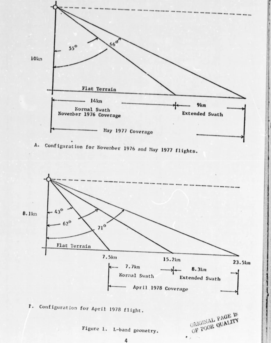
llyl-o watt•ly .'+ kill wide .11ld al+i+l•o\Irmt ely 1011 kill Iolltl. iht` 111, 1,itnto ,111,11,". tit the coveratle were rltl,liIied loo the April nlis •,ion; it 111 ,00,le,I ^,ilnil,l y ntll'tll "outhI l i.lht l ine•. l+ut I he "waths covere,l .ippro\iwat oly 1t+ kin. the `I Alt gt y r.letry for the koi,ol • I(It, artluired i , shown in I itlurt • i . the Noveriber
tlit ill t 11.1d ,1 in,11e lit, lari.• .Ititill t till ti,lu) • ,II it+11 (1111). the May fli kill t
provided du,+l pol. it- i:,Itit'll (fill ,111,1 IIV). mid
the Alit
,iI t1,+t,1 consi': od
of the fill
pol '11
•i.
•,it ion t'omplemellt (fill, IIV, VV and 'till).
1he Slav
data were ol+t
,lilled with the ,let iduouti trot 111 1Ill I IvaI i11 tht , 11 1.Ind,,t1ld most tlel,l: 1+1,tllte,l ill lt•t'.r1-.1., the April IIitlht•. kill lit it,tted
F
A
I I;I
l 1r^
t I ^ iI
I t 1 , 18. 14:r.,
r^
110 k:,
77
10
•tam ^ _--- ]
4km
Nurnal Swath November 1976 Coverage May 197'1 Coverage ---+--_ 9 k m Extended SwathA. Cotif igurat ion for Nove:lber 1976 and 11:t^ 1977 f I it;ht
^ . ^Kfl1
1
^). 1x11 7. I m — ---+, 8. 3km Aar, aI Swath Extended 5.,,,rtl, Apr i 1 1978 Coverage 23.5kmF•
Con
figuration for April 1978 fl ii;h[.
Lil _ - % U^
Nil W3
XIVVN . I 444
t a_ 1Figure 1. L-hand geometry.
the May coverage at a time of almost complete defoliation. Contrasting
t terrain conditions would permit evaluation of the vegetation penetration
r ;
i
i^
^i
i^
capability and any consequent advantage it might afford.
RADAR IMAGERY
In the upland regions of the test site both tho May and April
imagery of forested areas showed a relatively uniform gray tone and
cleared areas were uniformly dark. The pattern was the same for hoth
the like and cross polarized images, and little difference in discrimination
capabilit y was apparent among the various polarizations. Figure 2R is an
example of an L-band image (1111) from the `iay flights illustrating the
appearance of the upland regions. Figure ?A shows nearly the same area
as recorded by a Ka-hand (1111) radar system. However, in the lowland
areas, detailed examination of both polarizations produced by the May
flights revealed several regions of anomolous return. In tult.ivated
areas, well defined field ilatterns with intensity variations spannimI the full rankle
of the f i 1 iii were ev i
drnton the like polarized imagery.
The cross polarized imagery of the sa:.,e areas shoved all fields as a
relatively uniform low return with the field boundaries faintly visible,
apparently because of fencing and vegetation on the boundaries. These
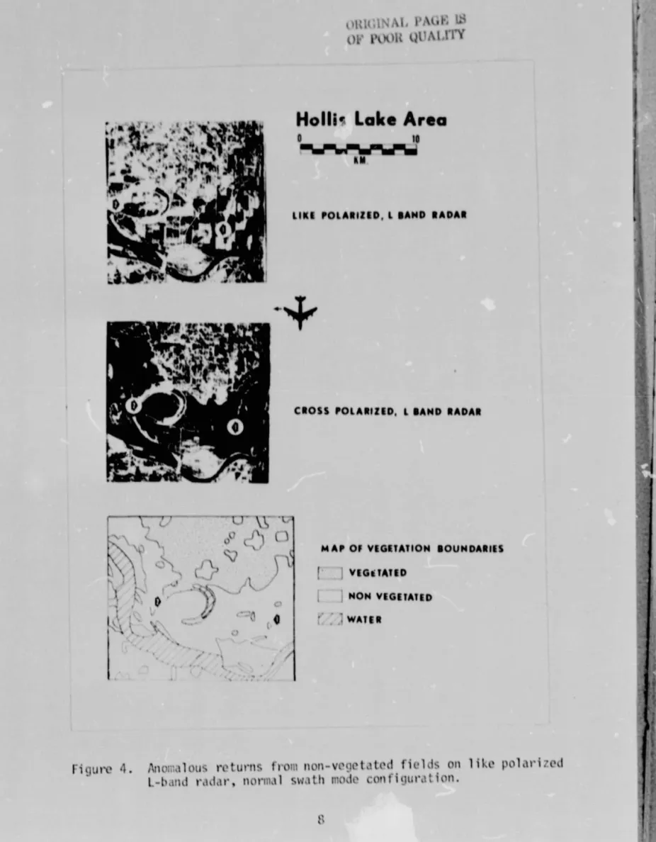
returns are shown in figure s, 3 and 4.
To investigate these anomalies, field checks of the areas including
discussions with individu,►1 farmers were conducted in an attempt to
establish the conditions at the time of overflight. host of the fields in
the areas were planted with soybeans which according tc planting dates
and crop calendar should have ranged from ,just emergent to a maximiwi
height of six inches at the time of imagin(l. The only discernible
^i
l
i^
i d
-I^
P ^r•F, [S U1,1v1
^XL
UpL[TY OF PWR ve ^^^ ^ b r1r R ^. t 1 in r w iN
U^ 4. 6 I w-0 (U rov
c b .o J U7 Q1 U^ rtf •r L rU Z7 N b C .L] •L -1 +j in ^, v +J N V M V1 RS E_ .^ ro^ N
^x 4- -c O +j (Ii a) rn +-) co rUF= E
•
r •r S_ O ro i _0 0. ro a cY ro J I I i L,L_.... _r*
V 71
ll K
'14 it
Hartman Lake Area
0 10
'
j
KMM'T'V~•^
E'KE POIARIIED I BAND RADAR^ T t
N
14:Uri 0L
ICI
1
CROSS POEARIIEO. E BANC RADAR
MAP Of VEGETATION BOUNDARIES
J VEGETATED ^, f NON VEGETATED r/ WATER C"
00
^---IG v.
^^4Q
o
Figure 3. Anomalous returns from non-vegetated fields on like polarized L-•band radar, normal swath mode configuration.
IL
IV
^•as .,
► • ^ a• ^ W E^w
+^ tNw' Rely14
otCROSS POLARIZED, L BAND RADAR
mucINAL PAGE U3
t)l., posm llUAIM"i
k^
I^•
Nulls- Lake Area
o to
KM
LIKE POLARIZED. l BAND RADAR
ti
t
0 1x
\
41 , 1 MAP OF VEGETATION BOUNDARIESI VEGETATED NON VEGETATED 1 'i f/ '^ Q WATER i
'r
I'
► ,IFigure 4. Anol;.alous returns front non-vegetatc , d fields on like polarized
l.-ha►td radar, normal swath mode configuration.
difference between fields was in row orientat ton, In every area
examined this pattern torrResponded directly with t ilt, return variation%
noted. Fields with rows paraIIel to the ft fight line were uniformly
hielh return whrre,ls those with rowN perpendicular to 'ne flight lime were uni formly low return. The row
pattern apparently causing
this widev,lriation in return si^tnal was ba%ically th.+t left by the pl,rnter and consisted of ridges approximately Fl cm high with AO cm sp.rcing. The height and definition cif these ridges at the title of overflight wer•eI much less than those found later in tilt, grc.,fing season atte►• repeated cultivation.
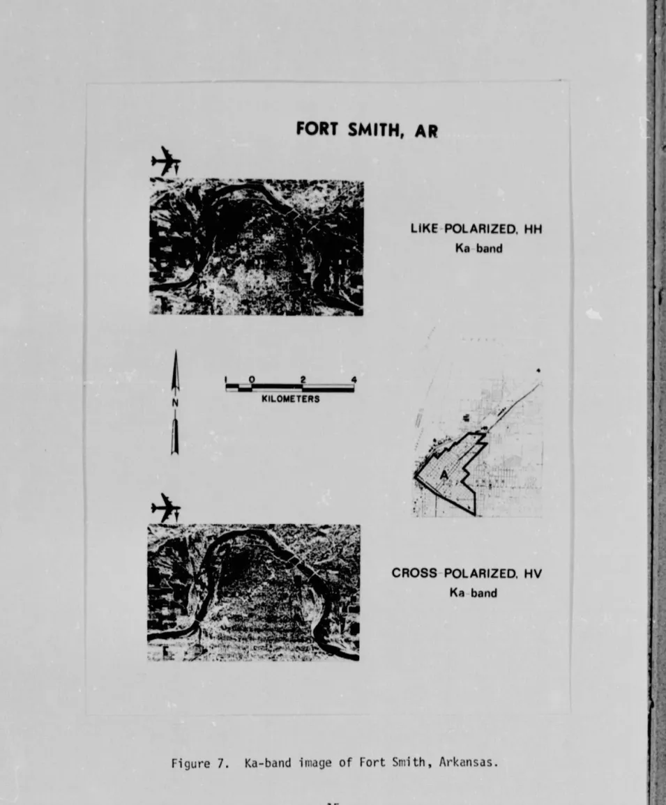
Another rt,aion of anomalous return was found in the city of Fort Smith. A large regular t a near the center of th:• city w.►s
well defined as a region of relatively low return oil like pol,rr is r,^ image. The same area of the cross polari:e,f image could not be
discriminated. Aj.,Jm. field examination proved this effect to bt, due to
orientation. Figure 5 shows the ira,ery and a street map
of
Fort S.:ithindicating that the region is defined by an ap!,r•e,\jj%jtvly -I
s
0 change intilt, >t reet orientation.
RADAR INTERPRETAT10%
Field_ Patterns The cause of the anoralou: field pattern w,rs easily determined tY post, flieiht field inspection to be the uniformity of
I
crops and cultivation, No row orier+tatie•+ sensitivity was neithernow nor surprising (Schwarz and Ca^i^.+11. l t ;^;;; *'or,iin and Coiner.
19711). However, the maonitu.ie of the var•iat ioll. sn,+nnin't the ful l dynamic 1.an;10
of the ima,le
fi le, r • ; • Iul t inkl su; h rolat ively S-.rl 1 r "w hoi,lhts^;a ' '^t art I ing.
9
r
I
I
LIKE POLARIZED, HH
L band
APPR
OXIMATE KALIIKIIOMITIRS A ^r
CROSS P OLARIZED, HV
L band I 1 1 1 +f + 1 1 1 1 • ORIGINAL VAVF^ 1^ orpl
.)l)it QU
A1.1'CY -4 1FORT SMITH, AR
I
I , IFigure 5. L.-band radar image of Fort Fmith, !Arkansas.
` Most observations of row orien • ation sensitivity have been at
r higher frequencies and/or in the presence of screening vegetation
(Batlivala and Ulaby, 1975). Consequently, the ground return has
been interpr-%ted by a Y.irchoff or physical optics model which is
inherently a high frequency rodel. T' o- usual interpretation is that
the near side of the rows tends to orient a greater portion of the surface
near normal to the inci.:ent radiation causing an incre-sed specular
I
return component. The frequency dependence of the orientation
sensitivity is interpreted as being a consequence of the greater vegetation
penetration capability of the lower frequencie; which causes the ground
to influence the return more at low frequencies and the vegetation to
mask the gr- A and give a more unifor-1 return at higher- frequencies.
The Iona -_veiength ane relatively lo,i height of the furrows in the
e-ampler shown here violate the basic assu-nptions of the physical optics
,i model rendering it unsuitable for this analysis.
1
The roughness scale and wavelength range in these examples aremuch more consistent with the P,ice or small perturbation model which is
inherently a low frequency model. Her-2 the return is basically considered
the summation from components in the surface roughness spectrum satisfying
the Bragg condition (Bar • r• ick and Peake, Though both the physical
optics and small perturbation models lead to Bragg scatter, the
interpreta-tion is more apparent in the small perturba t ion model and the scale is more
compatible with this model. The surface obviously has a broadly uniform
small scale roughness spectrums with an isolated large scale spike
corresponding to the row periodicity.
The mechanism observed here is apparently simple Bragg scatter,
however, there is no evidence of banding in the imagery such as would
be expected if the individual nodes or sidelobes of the Bragg diffraction
J ^^
pattern were discriminated. Because the surface is a composite of
several roughness scales,some filling of the pattern apparently occurs
to smooth out the distinct mode pattern ex,,ected from a single componer;t.
The lack of corresponding well defined patterns in higher
frequency imagery taken at tirr,es when lost fields are fallow leads
to the conclusion that there is a significant frequency dependence in the
effect of row orientation even in the absence of vegetation. As the
wavelength of the system approaches the period of the rows the lower order
Bragg modes dominate the return. At shorter wavelengths the higher
order modes are inure effectively smoothed by the higher frequency roughness
components. In essence this effect is simply another , manifestation of
"size filtering" in the rough surface radar return.
The lack of field definition in the cross polarized imagery is
attributed to the almost complete lack. of vegetation. The mechanism of
depolarization requires a double-bounce or reflectiuii, thus it is
much mote sensi.ive to volume scattering than to surface scattering,
particularly one that fits the criterion of slightly rough.
In those areas where the May coverage provided overLrp of normal
and extended swaths, returns in the far rage of the extended swath were
of diminished intensity in comparison with those from similar fields
imaged in the normal swath. Confirmation of the belief that re.tr-rn
intensity might also be incidence angle dependent was provided by the
April 1978 imagery. The April covera5e included two swaths of relatively
'large incidence angles (43 0 -71 0 figu r e 1), and the anomalous return
from bare fields was significantly red-iced. The diffraction or grating
effect caused by periodicity of the surface should, in general, he
inversely proportional to incidence angle. As incidence angle is increased,
^ 1\
I
i
T7 TI
.
higher modes are oriento.i in the 11acksclttor diroclion (oway from the
i radar} and these generally will dotr•easo tho return amp Iitudo. 11)tj
tho enhanced rot tit-it duo to sur•fake por•iodieity and OrienI at. iOn wouIkf he
expected to vanish at sufficiently Iar;o incidence it m.1 lit(, decrease
Witt) incidence angle, howovor. will he addition,111y inlluoneod by 1,kIw tit, i ght and spac i it .
Cultural Feat tit' The anowalow, pat.t-r',I in tho city Of fort Smith
k
MI example of tho "cardinal paint effect" noted several yoars ago.llholl tho 1.119v flat stiviaces of 11uildi ,!. ' Ire Oriented nklrulal to the
incidoiit radiation, the surtace and 11uildin,j act as a
eelr'ner
r,-flectok ('11ha11cing tht' like 11.11.111.,ed r'ottil'll. !t I.,1gles other th,lll Ilot,111.11 thereflected energy is directed away from thl''MCkscatt0l• dilo('LHOII.
iho effect Of onh,I lit- r,aont ran I " Seen ill K,1-11,111,1 image Of Now Orl k'ans Shown ill I i dure 6. lilt' sate pat.t e'I'll ill 1011 Snlif 11 is felunel
111 the Ka-band imago shown in Flkltire 7. lit ovel'Y case It is 00.11' that the' reflection mechanism does not tend to depolar•i.'o the si(lnal , thus tht' 11,01orns due' to •trcot orientation seen in the Iikt' polarized
iutakler• y are ahsen` kill the cross pol.iri:ed ima(iery.
1
LIKE POLARIZED, HH
Ka band
to v^CROSS POLARIZED. H V
Ka barn 10 r ''NEW ORLEANS, LA
t ^. ^f I^ Ir i I 1 0 1 2 N KILOMETERS U1tIGINAI.Y
p^^r; ►~or Ytx
011N"'IY
►►
t
^ArigLjre 6. U-band image of New Orleans, Louisiana.
LIKE POLARIZED, HH Ka band I r 1 0 2 4 N KILOMETERS j
FORT SMITH, AR
4 CROSS POLARIZED, HV Ka band 11 W,Figure 7. Ka-band image of Fort Smith, Arkansas.
4
SUM"!ARY
Long wavelength radar appears to offer some advantage in
vegetation penetration. However, the increased wavelength increases the
sensitivity to larger scale structure, especially at relatively small
angles of incidence. The regularity of agricultural and urban scenes
provide large components in the large scale portion of the roughness
spectrum that are highly sensitive to orientation. The range of return
variation due to the different orientation of relatively small rows
is seen to equ.rl or exceed what may be expected as a result of either
soil FlOisture or• vegetation differences. If long wavelengtrr radar is
to be used in an agricultural environment, it is essential that r.hi;
effect be identifiable to allow meaningful measurements of soil or
vegetation.
The addition of a cross ;polarized channel permits discrimin.1tion
of vegetation and orientational effects. This capahi1ity would he
essential for any a ,_lriculturOl application. Whether even this technique
provides sufficient correction to allow the measurement of soil moisture
cannot he determined. However, soil moisture measurement in the L-band
frequency range, at relative l y small angles of incidcmce, appears to
he impossible without the use of cross polarized data.
Ir , r ^
c
i^
Cr
LI
1 i 1t{ I 1 Ri NCFS t 11. Varrick, 11, W. and 111. 11. lar.11.c, A Rrvil'w of Scattl_'ring from Stlrfaces with Illftt'rt'nt Rou,.11111t's" Scalt`s. R.Idio `t lt`Ilcl', Vol. 1,
h,It Iiva1,l. 1'. I`. and I . 1. tllahy, 1Ito Lffl'ct of Lotto, 1)ire't t ittr► on thr I
R.lttar Rrtt,1'n fl'0111 a Row Crop. Rt'lllott` Sellsitttt laboratory lrt hnical
Report 4'0-1 . tl!1 i vt'rs i ty of Kan•. as , I xlrrrm-r . Kxns,r. , Mai- I t► ^:> . t .l. Matthews. Richard L.. e'd. , Act iv
e
Mit row.1vo Users 1lorkNhttp Roport.NASA t orate ronco l'uhl It at loll , 111/%8.
^. Mora ill , S. A. antl tl . C. COi11t•1•, I VaItl.lt IUI1 of I Ills` {a"..tlut ion Rati,ll•
Imagery for
tlaltinet Agricultural Ot,trrminatiow, CRIB lt`thilical Report1
11-1.
11101614-0 ty of KJIISLB Coll tt`I• Ior Rrsl'art 11 llit,
. ,
I awt•t`nt'e'.Kansas . H10.
5. Schwxl•; . 0. 1 . and 1. caspa I I , The' list` tit 1;x,1,11' ill t ht` Ili Sc
rird
n.t t kill ,lntl Ident ititation of Atli-it ill tural iand tkw, PI'tttt`t',IW,!,, IiIthJYltlpo .,1kill) t i ll Rt'mott` $e'rlsintl M 1 rI%. .iI . 1;"t`IIt. hill "i - slt ' t t t M.tchitl.ln, ^ t
1 1
1 i
1 !