SITWA REPORT
ON INFRASTRUCTURE DEVELOPMENT
This document has been produced with the financial assistance of the European Union. The views expressed herein can in no way be taken to reflect the official opinion of the European Union
TABLE DES MATIèRES
Table des matières ... 3
AbrEviations ... 5
Acknowledgements ... 7
Executive summary ... 8
List of tables ... 9
List of figures ... 9
1. Background and objectives of the consultancy ... 10
1.1 ANBO’s historical background and objectives ... 10
1.2 Background and objectives of SITWA ... 11
1.3 Objectives of the consultancy ... 11
2. Review of the existing infrastructure development ... 13
2.1 Purpose of the Review ... 13
2.2 Definitions ... 14
2.3 Programme for Infrastructure Development in Africa ... 15
2.4 Existing large hydraulic and hydropower infrastructures ... 16
2.5 Overview of large irrigated areas in Africa ... 19
2.6 Rivers and lakes transport infrastructures... 20
2.7 Green infrastructures ... 21
3. Identified gaps and priority areas to be addressed ... 22
3.1 General gaps for large water infrastructure ... 22
3.2 3.2 Role of transboundary River Basin Organizations ... 22
3.3 Importance of hydrological information and Decision support systems ... 23
3.4 Review and gaps for each institution ... 23
3.4.1 Transboundary basin organisations ... 23
3.4.1.1. ABAKIR ... 23 3.4.1.2. CICOS ... 23 3.4.1.3. LCBC ... 24 3.4.1.4. MRA ... 24 3.4.1.5. MRU ... 24 3.4.1.6. NBA... 24 3.4.1.7. NBI ... 25 3.4.1.8. OMVG ... 25 3.4.1.9. OMVS ... 25 3.4.1.10. OKACOM ... 26 3.4.1.11. ORASECOM ... 27 3.4.1.12. VBA ... 28
3.4.1.13. ZAMCOM and ZRA ... 29
3.4.2 Regional and continental institutions ... 31
3.4.2.1. ECCAS ... 31
3.4.2.2. ECOWAS/WRCC ... 31
3.4.2.3. ICA ... 31
4. Action plan - List of activities and budget ... 33
5. Recommendations for ANBO ... 36
6. Conclusions ... 37
7. Annexes ... 39
7.1 Detailed work plan, budget and time frame from 2015 to 2019 ... 39
7.2 List of documents consulted ... 43
ABREVIATIONS
Abréviation Définition
ABAKIR Lake Kivu and Ruzizi River Basin Authority
AfDB African Development Bank
AMCOW African Ministers Council on Water
ANBO African Network for Basin Organizations
AUC African Union Commission
AWIS African Water Information System
CICOS Commission Internationale du Bassin Congo-Oubangui-Sangha
CIWA Cooperation of International Waters in Africa
CSO Civil Society Organization
DRC Democratic Republic of Congo
EC European Commission
ECA East African Community
ECCAS Economic Community of Central African States
ECOWAS Economic Community Of West African States
ENSAP Eastern Nile Subsidiary Program
EU European Union
FAO Food and Agriculture Organization
GWPO Global Water Partnership Organisation
ICA Infrastructure Consortium for Africa
IDB Islamic Development Bank
IGAD Intergovernmental Authority on Development
INBO International Network of Basin Organizations
IWRM Integrated Water Resources Management
KOBWA Komati Basin Water Authority
LCBC Lake Chad Basin Commission
LHWP Lesotho Highlands Water Project
LIMCO Limpopo Basin Commission
LTA Lake Tanganyika Authority
LVBC Lake Victoria Basin Commission
MRU Mano River Union
NBA Niger Basin Authority
NBI Nile Basin Initiative
NELSAP Nile Equatorial Lakes Subsidiary Action Program
NEPAD New Partnership for Africa's Development
NPCA NEPAD Planning and Coordinating Agency
Abréviation Définition
OKACOM Okavango River Basin Water Commission
OMVG Organisation pour la Mise en Valeur du Fleuve Gambie
OMVS Organisation pour la Mise en Valeur du Fleuve Sénégal
ORASECOM Orange–Senqu River Commission
PIANC World Association for Waterborne Transport Infrastructure
PIDA Programme for Infrastructure Development in Africa
PJTC Kunene Permanent Joint Technical Committee
PMT Project Management Team
PSC Project Steering Committee
RBO River Basin Organisation
REC Regional Economic Commission
RISDP Regional Indicative Strategic Development Plan
RWSSP Regional Water Supply and Sanitation Programme
SADC Southern African Development Community,
SAP Strategic Action Programme
SDAGE Schéma Directeur d’Aménagement et de Gestion des Eaux
SITWA Strengthening the Institutions for Transboundary Water Management in Africa
SOGED Société de Gestion et d’Exploitation du Barrage de Diama
SOGEM Société de Gestion de l'Energie de Manantali)
ToR Terms of Reference
VBA Volta Basin Authority
WCD World Commission on Dams
WRCC Water Resources Coordination Center
ZAMCOM Zambezi Watercourse Commission
ZRA Zambezi River Authority
ACKNOWLEDGEMENTS
The SITWA project team and the consultants would like to express their gratitude to the Chair of ANBO as well as to the AMCOW Secretariat for their invaluable guidance provided during the course of this assignment.
We would further like to thank the representatives of African L/RBOs, RECs, etc., (including the participants in the workshops), who contributed their time and expertise throughout the duration of this assessment and whose contributions were extremely valuable for the development of this report. INBO also thanks the Global Water Partnership Organisation (GWPO) who manage the EU funds, and the SITWA Project Management Team who is implementing the project.
We are grateful to all of these individuals for their time, insights, and inputs.
Last, but not least, we express our gratitude to the European Commission who provides the funding for the SITWA project.
ExECUTIVE SUMMARY
LExecutive summary
The main purpose of this consultancy is to identify priority actions from infrastructure development in the African river basin organizations, and present a 5 year detailed program, within ANBO’s mandate and SITWA’s objectives. According to the PIDA1 report, only 30% of the population living around the
basins have access to electricity; current levels of water withdrawal are low, with only 4% of water resources developed for water supply, irrigation and hydropower use and with only about 18% of the continent’s irrigation potential being exploited. Transboundary Water Resources in Africa represent an opportunity for development of multipurpose regional infrastructure aimed at energy production, food security and inland transport, water supply for domestic and industrial uses, and climate adaptation and resilience.
Review and gaps for each Lake or River Basin Organization (where existing) show (depending on each case) the need for clarifying roles in infrastructure development, confidence enhancing between countries, institutional set-up, Public-Private Partnerships models, capacity building and development of investment plans.
The 5-year (2015-2019) Action Plan of the concrete actions / support services, which could be provided by ANBO (and other partners) to the L/RBOs in terms of infrastructure development, includes three components: sensitization, technical support and Benchmarking of good practices.
The main priority actions are:
• High level Forum on Nexus Water/Food/Energy and Multipurpose dams;
• Participation in the development and implementation of guidelines for large infrastructures environmental and social assessment;
• Prioritization of large infrastructures in “no PIDA” basins;
• Transboundary water infrastructure projects inventory - Data base and update; • Organisation of a dialogue on large water infrastructures in Central Africa. The main recommendations and concluding remarks are as follows:
ANBO is only a network and has an essentially a role of advocacy;
• Role of L/RBOs in every stage of large infrastructure development projects must be strengthened, under the umbrella of REC. Coordination between RECs, ANBO, PIDA and ICA is necessary; • Transboundary hydraulic infrastructures, when consensually and wisely planned, can widely
enhance regional development and favour peace and cooperation between States sharing a same basin. Decision support systems offer the best chance to obtain a consensus between countries of a same basin on planning of a common infrastructure scenario;
• Multi-purpose dams can help to optimize the economic profitability of existing or planned developments. In dry areas, large retention dams are often the main solution for adaptation to climate change;
• Integrating values for natural infrastructure opens the possibility of optimizing infrastructure development between countries. It then becomes possible to identify mixed portfolios of engineered and natural infrastructure that could best meet multiple development objectives; • Communities affected by infrastructure must be involved as partners, and benefit directly from
the dam throughout its life cycle.
LIST OF TABLES
Table 1. Criteria for PIDA water prioritization ...16
Table 2. Hydroelectricity development in the world ...17
Table 3. Infrastructure development in River Basin Organizations ...30
Tableau 4 : Résumé des volets, des principales actions et des activités ...33
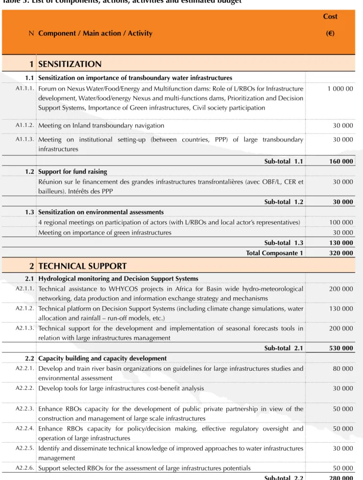
Table 5: List of components, actions, activities and estimated budget ...34
LIST OF FIGURES
Figure1. Rivers Basins of Africa (from Transboundary Freshwater Dispute Database) ...14Figure 2. Existing dams in the selected basins (PIDA, 2011) ...18
1. BACKGROUND AND OBJECTIVES OF THE
CONSULTANCY
1.1 ANBO’s historical background and objectives
Following the adoption of the Africa Water Vision 2025, the African Union called in 2000 for a “Federation of African River and Lake Basin Organizations” to be created to develop and adopt a common approach to the management of transboundary waters. In response to this call, AMCOW established, in 2006, the “Tekateka Committee” which recommended the adoption of the African Network of Basin Organisations (ANBO), which had been created in 2002, to provide this common platform, and come up with recommendations to harmonize the working relationship between AMCOW and ANBO with regards to African L/RBOS. It was in this spirit that the Tekateka Committee recommended a revised version of ANBO statutes which was adopted at the ANBO General Assembly (GA) held in South Africa in March 2007. ANBO was designated as a sub-committee of AMCOW in matters relating to Water Resources Management. Later in 2009, ANBO General Assembly decided to formalize its relationship with AMCOW.
ANBO is a network whose objective is to promote IWRM at the level of river, lake, and aquifer basins and is an essential tool for sustainable development. Its mandate is to:
• develop co-operation between the organisations in charge of integrated water resources management and to favour exchange of experiences and expertise among them;
• participate actively in policy formulation and implementation, bringing in experience of practice, as well as carrying out diagnostics, analysis enabling the harmonisation of policy, strategies and practices at national levels, as well as the level of basin and sub-basins;
• promote and strengthen existing organisations and to encourage the creation of new basin organisations;
• facilitate the development of tools suitable for institutional and financial management, for knowledge and monitoring of water resources, for the organisation of data bases, for the concerted preparation of master plans and action programmes in the medium and long term;
• strengthen and network the existing documentation and information centres of the member organisations, to produce, exchange, synthesize and disseminate knowledge and the know-how of IWRM, in collaboration with their regional and international partners and to support the creation of new water-related documentation and information systems in the organisations which have none;
• develop information and train the officers and personnel of basin organisations and water sector administration and to promote populations’ education on these issues in order to carry out studies and to prepare educational material;
• promote IWRM principles of the basins in international co-operation programmes; • Evaluate actions initiated by the member organisations and disseminate their results;
• organise joint activities of regional interest between the members and support their actions in obtaining finance in particular;
• Support the African Ministers Council on Water (AMCOW), to meet its specific requests on management per basin and implement its orientation in the field.
To achieve its objectives ANBO should actively contribute to the development and strengthening of lake and river basin organisations and catalysts for better regional cooperation at the political, economic, and stakeholder level that will promote enhanced transparency, better understanding, and greater development cooperation among riparian countries. ANBO facilitates and strengthens, particularly within the International Network of Basin Organisations (INBO), the connection between its members
and the basin organisations of other continents and participates in international joint activities, aims to develop IWRM, which it implements in Africa.
It is against this background that the European Commission (EC) decided to fund SITWA, a three years project aimed at strengthening regional cooperation for the sustainable management of transboundary water resources in Africa, through the programmatic and institutional strengthening of ANBO, and improvement of water governance for transboundary water resources management in Africa under the platform of ANBO.
1.2 Background and objectives of SITWA
The SITWA project (Strengthening the Institutions for Transboundary Water Management in Africa) is implemented by the Global Water Partnership Organization (GWPO) in partnership with the ANBO Technical Secretariat, hosted by the Organization for the Development of the Senegal River (OMVS). A joint GWPO/ANBO Project Steering Committee (PSC) has been established and a Project Management Team (PMT) has been put in place at the ANBO Technical Secretariat in Dakar, Senegal.
The overall objective of SITWA is to strengthen regional cooperation at the political, economic and stakeholder level for sustainable management of transboundary water resources in Africa, contributing to peace and security, stability and poverty alleviation, based on African knowledge.
The specific objectives of SITWA are:
• Objective 1 – ANBO is transformed into a sustainable and influential organization as a pillar
under AMCOW: the project is aimed at transforming ANBO into a sustainable and influential organization, as a pillar under the African Union and AMCOW framework that supports the development of lake and river basin organizations as catalysts for policy and institutional development, knowledge and information management and capacity development on transboundary water management and development.
• Objective 2 – The ANBO Program to be implemented and Technical Assistance provided
through the RECs: ANBO with GWPO support will provide technical assistance to the RBOs (through the RECs and their respective member states) to develop IWRM strategies and plans (including addressing vulnerability to floods and droughts, priority issues for short and long term development, water quantity analyses and water quality objectives, etc.) in the river basins where they are not yet developed, and to implement plans where they exist.
The project is being implemented in two phases: an inception phase and an implementation phase. The Inception Phase took 12 months, between October 2012 and October 2013. The main result of the Inception Phase was the Inception Report with individual thematic reports. An implementation phase is in place for a three - year duration (January 2014-December 2016).
The current study has the objective to contribute to the preparation of a long term ANBO programme focusing on the current situation and needs of RBOs regarding the IWRM planning, climate and development agendas in the RBOs, and infrastructure development. These thematic areas are related respectively to WP 7, WP 8 and WP 10 out of 10 WP (Work Packages) of the SITWA Project. This report consists of the assessment and action plan for the development of the WP 10: infrastructure development in the African river basin organizations.
1.3 Objectives of the consultancy
This consultancy takes place within a set of consultancies whose objective is to contribute to the preparation of a long-term ANBO programme focusing on the current situation and needs of African RBOs. The main purpose is to identify priority actions from the above theme and present a 5 year detailed program, within ANBO’s mandate and SITWA’s objectives.
The Terms of Reference for the production of this report indicated the following outputs of the consultancy:
• overview of the state of the situation regarding the water related infrastructure development in the African RBOs with a special focus on hydropower and multi-purpose dams with the purpose of identifying areas for which ANBO could provide some useful services;
• identification of gaps and assessment of the needs of RBOs for improving infrastructure development in RBOs;
• identification of priority support services (actions) which could be provided by ANBO in the scope of its mandate;
• preparation of an action plan of 5 years (2015-2019) for ANBO based on the identified gaps/ needs.
2. REVIEW OF THE ExISTING INFRASTRUCTURE
DEVELOPMENT
2.1 Purpose of the Review
The African continent has the highest number of transboundary river basins that collectively cover 64% of its surface area and contain slightly more than 93% of its surface water resources (SITWA, Inception Report 2013). Despite the existence of so many Transboundary Rivers and Lakes on the continent, these resources are underutilized and the needs regarding basic needs (electricity, food, drinking water, sanitation) are still critical.
According to the recent PIDA report, only 30% of the population has access to electricity, current levels of water withdrawal are low, with only 4% of water resources developed for water supply, irrigation and hydropower use, and with only about 18% of the continent’s irrigation potential being exploited. The importance of large regional infrastructure development cannot be overemphasized. All Africa’s leading continental organizations and associated technical and financial partners, including AUC (African Union Commission), NEPAD Planning and Coordinating Agency (NPCA) and the African Development Bank (AfDB), have worked for years to address the infrastructure deficit. In addition, the G20 Infrastructure Action Plan, Infrastructure Consortium for Africa (ICA), EU (European Union) Africa Infrastructure Trust Fund and Africa Infrastructure Country Diagnostic all highlight the importance of regional infrastructure for Africa’s growth. Large infrastructures play a key role in economic growth and poverty reduction.
The World Bank has developed a new Project called Cooperation of International Waters in Africa (CIWA) that aims to develop infrastructure in the water sector, taking as a basis the dimension and scope of transboundary river basins. The SITWA Project has already established links with most of these initiatives, which have recognized the relevance of the involvement of ANBO (African Network of Basin Organizations) in the assessment of RBO (River Basin Organizations) infrastructure needs coupled with regional and national development priorities.
The lack of infrastructure affects productivity and raises production and transaction costs, which hinders growth by reducing the competitiveness of businesses and the ability of governments and regions to pursue economic and social development policies. African countries, particularly those south of the Sahara, are among the least competitive in the world, and infrastructure appears to be one of the most important factors holding them back.
Closing the infrastructure deficit in Africa is vital for economic prosperity and sustainable development. But it is a regional and continental problem that requires a regional and continental solution. Africa’s economic geography is particularly challenging, and because its infrastructure needs are so huge, regional integration is the best, and perhaps only, way for Africa to realize its growth potential and equitably share the benefits of an increasingly connected world marketplace.
Transboundary Water Resources in Africa present an opportunity for development of multipurpose regional infrastructure aimed at energy production, food security, and inland transport, water supply for domestic and industrial uses, and climate adaptation and resilience.
The present Chapter presents an overview of the state of situation regarding existing large water related infrastructures in Africa (hydropower, irrigation schemes, rivers and lakes transports infrastructures, multipurpose dams), including constraints, gaps and the role of RBOs.
Figure1. Rivers Basins of Africa (from Transboundary Freshwater Dispute Database)
2.2 Definitions
To adopt a common language, the following definitions are proposed.
• Transboundary waters are taken as “international watercourses”, which have been defined in
Article 2 of the Convention on the Law of the Non-navigational Uses of International Watercourses as follows.
• Watercourse means a system of surface waters and groundwater constituting by virtue of their
physical relationship a unitary whole and normally flowing into a common terminus.
• International watercourse means a watercourse, parts of which are situated in different States. • Large dam: Abiding by the definition of the International Commission on Large Dams, i.e. a dam
with at least one of the following characteristics: i-) height above foundations higher than 15 m, ii-) height between 10 and 15 m, with top width superior to 500 m, or flood spillway of capacity superior to 2,000 m3/s, or reservoir volume superior to 3 million m3.
• Large hydro-power infrastructures: These include infrastructures with an annual energy
production superior to 150 GWh. It should be noted that a dam could be “large” without meeting this criterion.
• Large water transfers: These include inter or intra-basin water transfers the annual derivative
water volume of which, recorded at deduction point (thus integrating evaporation), is superior to 3 hm3.
• Large irrigated areas: these include irrigated areas of more than 10,000 ha, from one single site
of water supply connection (pumping or gravity). In Africa irrigation systems may be classified into four major typologies based on such criteria as ownership/management, source of water, type of infrastructure or technology involved, and source of power for abstracting, conveying and distributing water. These are: public systems, small reservoirs and dugouts, river/lake private systems and groundwater systems. These four typologies can be subdivided: Public-owned surface irrigation systems, Public-private partnership commercial systems, Small reservoir- and dugout based systems, Private- or group-based river lift systems, Groundwater-based irrigation systems; lowland/inland valley rice water captures systems.
• Large water infrastructures: such projects come under four categories: ■ Large dams;
■ Large hydro-power infrastructures; ■ Large water transfers;
■ Large irrigated areas.
• Common infrastructures: a facility the Member States of the basin organisation have decided by
a legal instrument to be their common and indivisible ownership.
• Common interest infrastructures: a facility in which two or several basin organisation Member
States have an interest and which coordinated management has been decided by mutual agreement between the Member States.
• Transport infrastructures: large inland ports, and artificial canals.
• Green infrastructures: water ecosystems (wetlands…) which provide different services (water
storage and transfer, filtration, waterways transport, flood control, flooding protection…).
2.3 Programme for Infrastructure Development in Africa
The Programme for Infrastructure Development in Africa is a joint initiative of the African Union Commission, NEPAD Secretariat and the African Development Bank. Its purpose is to promote regional integration in Africa through the development of infrastructures at regional and continental levels. A PIDA Priority Action Plan has been drafted up to 2020.
PIDA covers four sectors: transboundary waters, energy, transport, and information and communication technology. The African Water Facility is financing the “transboundary water” component. It focused on ten selected Transboundary Lake and River basins, namely Lake Chad, Congo, Gambia-Geba-Koliba, Niger, Nile, Okavango, Orange-Senqu, Senegal, Volta and Zambezi. The selected basins straddle, partly or completely, most African countries and account for 52% of African land area and 80% of the total area of the African international basins.
Prioritization of major hydraulic infrastructure projects has been made at the level of large transboundary surface water and groundwater catchments areas. Various economic, environmental, social, technical and institutional criteria were used for this prioritization. The selection criteria for water infrastructure projects were categorised into five thematic groups, comprehensively covering the aspects pertinent for successful project development and implementation:
Table 1. Criteria for PIDA water prioritization
Groupes de critères Aspects couverts
1. Economic and financing Ce groupe de critères mesure la faisabilité économique
et financière et la viabilité du projet, la disponibilité des financements et l’attractivité du PPP.
2. Environement and social Ce groupe de critères mesure l’impact du projet sur
l’environnement (et le changement climatique) et la manière dont le projet est conçu pour limiter son impact sur l’environnement.
Ce groupe de critères mesure également la manière dont le projet est susceptible d’agir sur son environnement social, en termes d’avantages pour les populations, des personnes affectées par le projet, de réduction de la pauvreté, et sur le niveau de vie. La majorité de ces aspects sont quantifiables.
3.Évaluation institutionnelle et politique Ce groupe de critères est lié aux aspects de la propriété, à la
fiabilité des prévisions, aux dispositions de mise en œuvre et d’exploitation, et aux aspects relatifs à la réglementation et à l’harmonisation. Certains de ces aspects sont basés sur des analyses d’experts.
4. Synergie entre les secteurs du PIDA La synergie se mesure par la contribution du projet à
l’amélioration du réseau d’infrastructures dans un ou plusieurs secteurs du PIDA. Cet aspect est quantifiable.
5. Critère technique Dans les différents secteurs, il y a une série d’indicateurs
techniques généralement pris en compte qui ciblent souvent les normes physiques ou non-physiques.
The Transboundary Basin Organizations (thus ANBO) and the Regional Economic Commissions play an important role in the implementation of the projects to be selected. This implementation is accompanied by a progressive institutional capacity building of the basin organizations according to proven models.
2.4 Existing large hydraulic and hydropower infrastructures
Many of the large dams in Africa were built before 1988 with a few having been completed in the last two decades. While a number of pre-investment studies are ongoing, at present only a few projects are at the stage of detailed design. Whereas multi-purpose dams are increasingly being conceptualized, most of Africa’s dam infrastructure in the past was built with hydropower generation as a primary purpose, followed by irrigation supply.
A PIDA study led to the conclusion that at present, only 8% of the total estimated hydropower potential in the ten selected basins are being exploited with the total installed capacity at around 15 756 MW. Of this around 65% are located in the Nile and Zambezi river basins (with 34% and 31% installed capacity respectively), and a further 23% of installed capacity found in the Niger (13%) and Volta river basins (10%).
Similar to the situation described for installed hydropower capacity, the bulk of the current existing storage capacity is concentrated in only a few basins. For example, of the total storage capacity in the PIDA basins of 669 billion m3, 66% are in the Kariba, Cabora Bassa (both Zambezi basin), Akosombo (Volta basin) and High Aswan dams (Nile basin) as illustrated in figure 1.
Also, despite its comparatively low storage capacity in absolute terms (given the relatively small total annual runoff), the Orange-Senqu River basin is one of the most developed river basins in the world, with several large dams and the world’s largest international inter-basin transfer.
Table 2. Hydroelectricity development in the world
Continent "% % inexploité techniquement et économiquement faisable % inexploité techniquement faisable % site inexploité mais faisable in operation" "% 19,5 45,0 64,5
unexploited technically and
economically feasible" "% 34,4 40,2 74,6 unexploited technically feasible" "% 26,0 29,7 55,7 unexploited site but feasible" 7,4 48,3 44,3 92,6
Asia 17,4 41,9 40,7 82,6
2.5 Overview of large irrigated areas in Africa
The potential for irrigation schemes in Africa is very good although the experience in irrigated agriculture is relatively limited. The main beneficiaries of the irrigation infrastructures are smallholder farmers. However, the output has not been greatly encouraged and the lack of maintenance has rendered most of the schemes partly unproductive.
In the 10 PIDA basins, the area equipped at present for irrigation stand at around 6.2 million hectares, which represents around 20% of the estimated potential in these basins. At the continental scale the irrigation potential in Africa has been estimated by FAO at more than 42 million ha, amongst which 31 million ha are located in the PIDA basins. Almost one third of this potential is located in only two humid countries: Democratic Republic of Congo and Angola.
Critically, the biggest challenge for the expansion of irrigated agriculture in Africa is the low efficiency of production. The major constraints can be grouped into 4 major areas :
• Financial and institutional concerns - Inadequate maintenance in public irrigation systems,
inability to raise revenues from users, high cost of capital and limited access for private investments. Lands on which public systems are built are later claimed back by owners; only temporary investments due to absence of rights; weak autonomous organization and collective management; difficult access to inputs, equipment, accessories and services.
• Output marketing, post-harvest handling and value additions. The oligopolistic nature of product
markets, in which a small number of buyers (e.g. market women, millers, export agents, etc.) control the purchase of irrigated agricultural products, allowing them to exert a great deal of control over the producers prices and constrain the development of irrigation.
• Technical constraints. In Africa, irrigation infrastructure designs fail to consider the multi-functionalities and the crop–livestock interactions; livestock can destroy irrigated crops during the dry season, when feed sources are limited unless the field is fenced, which can be a major cost item. Siltation of reservoirs and canals, and extreme flooding events are major impediments to the sustainability of some irrigation systems. Agricultural practices in the immediate catchment area of reservoirs can cause severe siltation problems in some cases. Siltation diminishes the storage capacity of reservoirs and de-silting / rehabilitation can be a financially demanding exercise. Many irrigation infrastructures have collapsed resulting in waste of water as well as restricting irrigation schedule. Even at schemes where rehabilitations have been completed, it is common to observe broken down irrigation infrastructure.
• High investment costs due to inadequate local expertise in planning and construction of irrigation
infrastructures, inadequate feasibility studies leading to costly design changes, costly involvement in construction of on-farm works; delays in imported inputs, mechanization of construction rather than labour-intensive techniques; use of tied funds often involving additional supervision and administrative costs, procurement of non-standard equipment with special operation and service arrangements; relative inflexibility in infrastructures construction by governments and lending agencies, and hence the use of foreign firms for construction; over-designing due to insufficient knowledge of local conditions and high bids based on perceived risks of operating in some countries.
Figure 3. Zone équipée pour l’irrigation versus potentiel (PIDA, 2011)
2.6 Rivers and lakes transport infrastructures
The main regional inland waterways in Africa are mainly limited to five Rivers - the Nile, the Congo, the Niger, the Senegal and the lower Zambezi Rivers, and three lakes -, Lake Victoria, Lake Tanganyika and Lake Malawi.
Currently, river and lake transport serve essentially only the people living directly along rivers while river and lake based long haul traffic has practically completely disappeared. The main reason is that the rivers and lakes are not appropriately maintained for navigation and transport purposes; for example inland ports are not well maintained and developed, dredging is not carried out, the navigation systems are not correctly maintained and the fleets are old and sometimes in very poor conditions.
2.7 Green infrastructures
The services provided by aquatic ecosystems (rivers, lakes, streams, wetlands, aquifers, estuaries and marine deltas) are many and varied :
• Goods produced or provided (water supply, agriculture, animal husbandry, fisheries, wildlife, fibre and wood, genetic and biochemical resources);
• Regulation (lateral flow expansion, floods slowdown and control, protection against flooding, sediment retention and transport, groundwater recharge and drainage, low water replenishment, waterways transport, maintaining biodiversity, self-purification, CO2 storage, pollination, habitats);
• Cultural and religious services (landscape, heritage, values, history, recreational activities, ecotourism).
In the case of transboundary basins, these benefits are felt beyond the borders, particularly with regard to flood control, low water replenishment by groundwater, self-purification by wetlands. The economic, social and cultural values of aquatic ecosystems should thus be shared between the countries of the same basin.
Critical services from nature equate to most functions of infrastructure. Upland forests, aquifers, lakes and wetlands provide water storage, wetlands filter water, rivers provide conveyance and transportation, floodplains and wetlands lower flood peaks in downstream countries and cities, while mangroves, coral reefs and barrier islands protect coasts against storms and inundation.
With the term infrastructure defined as “the stock of facilities, services and installations needed for the functioning of a society”, nature is part of infrastructure portfolio of every country and every economy. Nature is then “green infrastructure” or “natural infrastructure” based on its capacity to complement or augment the services provided by traditional engineered infrastructure, including transboundary ones. Natural infrastructure does not replace the need for built infrastructure or “grey infrastructure”. The multiple ecosystem services provided by natural infrastructure multiply the benefits received. In this sense, well-functioning natural infrastructure is necessary for built infrastructure to perform its functions better, to ensure projected benefits shared by countries and to increase returns on investment.
3. IDENTIFIED GAPS AND PRIORITY AREAS TO BE
ADDRESSED
3.1 General gaps for large water infrastructure
Africa has 15% of the world’s population but accounts for only 3% of the world’s primary energy consumption (renewable energy and waste excluded) and 5-6% of world’s final energy consumption (renewable energy and waste included). Electricity consumption per capita is 1/6 of world overall average. Access rates, particularly in Sub-Saharan Africa, are amongst the lowest in the world with only 1/5 of the population having access to electricity. For the reference period until 2040, power demand for Africa as a whole is projected to increase considerably by a factor of four (410%) with an average energy demand growth rate of 5.5% over the entire period.
The planning model of the PIDA energy sector estimates that, in addition to the currently installed 15 756 MW, a further 72 563 MW will be commissioned (in the 10 selected basins) in the period until 2040 amongst which an estimated 65% will be in the Congo basin, 19% in the Nile basin and 13% in the Zambezi basin. In terms of determining the hydropower infrastructure gap, two types of gaps can be distinguished, namely:
• The theoretical gap, defined as the difference between the current developed (and under construction) hydropower generation capacity and the estimated (theoretical) potential. The theoretical gap is estimated to be 179 744 MW;
• The planning gap, defined as the difference between the current developed (and under construction) hydropower generation capacity and the planned installed capacity in 2040, given the commissioning calendar established by the planning model of the PIDA energy sector. The planning gap is estimated to be 72 563 MW (39.5 % of the theoretical gap)
Currently, merely 20% of the potential irrigation area in Africa is exploited. During the last decade (from 1998 to 2008), the annual growth rate of area equipped for irrigation in Africa was only half of the one observed in the World (0.6% compared to 1.1%). In terms of irrigated area, this represents an annual increase of 81 030 ha per year in Africa. The modelling carried out by the PIDA has estimated the irrigation gap which (for the medium population growth scenario) would require an increase of 13 million ha until 2040 compared to 2008.
3.2 3.2
Role of transboundary River Basin Organizations
As described in the PIDA report the mandate of RBOs to raise finance and implement projects varies considerably depending of their mandate. Against this background, the role of RBOs needs to be carefully distinguished and their role be defined on a project-by-project basis.
For basins where organizations have the mandate for implementing large hydraulic infrastructure, the proposed approach in the short term is to give priority to physical investments implemented by the RBO to consequently ensure more substantial financial support to these projects. For (the majority) of basins where RBOs do not have the mandate for implementing large hydraulic infrastructure, other approaches have to be taken. One option is to facilitate a change in mandate of the RBO towards infrastructure development with direct and tangible economic return for the people of the basins where this change is desired by the RBO Member States.
At the same time it needs to be realised that a change of mandate for an RBO would often require a change of treaty, which, even if desired, is a time-consuming process. Likewise, many (if not most) RBOs in their internal governance structure and equipment with (human and financial) resources are not capacitated for project preparation and infrastructure development. Their organizational set-up and capacity has been geared towards overall basin assessment, planning and management in line
with their primary mandate of advising the Member States. These functions remain relevant and need to be maintained. Re-focusing the mandate of the RBO entirely towards infrastructure development puts continued carrying out of these functions at risk without necessarily increasing the efficiency and effectiveness of infrastructure project preparation and implementation.
In determining the institutional arrangements for transboundary water resources infrastructure projects it is important to closely examine whether the establishment agreement authorises the commission or organisation to raise finance and implement capital projects. In some cases, a new international treaty may be required with the full procedure for the ratification of international treaties and this can be expected to be a protracted affair. In other jurisdictions the law allows a head of state or minister to authorise a state’s participation in an international organisation
3.3 Importance of hydrological information and Decision support systems
The hydrological information is the basis of any management of the water resources, of which the relevant scale is the watershed. In addition to the direct use of the measurements themselves or derived data, this information is useful for other purposes and its «added value», at the trans-boundary level, is multiple, especially for cross-border planning of large hydraulic infrastructures, their management and sharing of their benefits between countries.
Decision-support tools give the opportunity to simulate the hydrological processes and the resources allocation depending on the uses and the geographical areas in the basin. Using this type of tool allows optimizing economical investments, taking into account social and environmental impacts through multi-criteria analysis, which facilitates profit sharing between countries. Strategic decisions regarding large infrastructures can then be taken (often at the highest level), leading to a consensual long term transboundary planning.
3.4 Review and gaps for each institution
3.4.1 Transboundary basin organisations3.4.1.1. ABAKIR
The Lake Kivu and Ruzizi River Basin Authority (ABAKIR) was created in 2011. Its Member States are Burundi, DR Congo and Rwanda. The water resources are considered of great potential to the three countries, especially for production of hydropower, which is essential for bridging the power deficit within the Great Lakes region. Ruzizi River has the great potential to produce 450 MW of hydroelectricity while Lake Kivu has the capacity (gas) to produce around 700 MW (gas).
The existing Ruzizi I&II power complex is operated jointly by Burundi, DR Congo and Rwanda. ABAKIR is in charge of the development of Ruzizi III and IV projects, following Public-Private Partnership model. Other expected investments on water resources include navigation, hydropower generation and irrigation. Another objective is to reduce pollution around the water basins.
3.4.1.2. CICOS
The Congo is the Earth’s second largest river by volume and has the world’s second largest rainforest (18% of the planet’s remaining tropical rainforest). The Congo River basin has the highest potential for hydropower development in the world. It is estimated to be around 123,600 MW amongst which 39,000 MW in the single Grand Inga project.
The International Commission of the Congo-Ubangi-Sangha Basin (CICOS) was created for inland navigation enhancement in 1999 (effective in 2003) by Cameroon, Central African Republic, Congo and DR Congo. Its mandate was widened in 2007 to Integrated Water Resources Management. Gabon has joined CICOS recently.
Water Planning and Management Master Scheme (SDAGE) elaboration by CICOS is ongoing. It is helped through a hydrologic model (Decision support system) for the comparison of infrastructure scenarios. An Investment Program will be produced arising under the SDAGE.
The production of studies relating to common interest infrastructures is in the mandate of CICOS, but not the implementation and operation of the structures themselves. Palambo dam is the project selected by PIDA in the Congo River basin. Old feasibility studies must be brought up to date and the Terms of reference have been produced by CICOS.
3.4.1.3. LCBC
The Lake Chad Basin Commission (LCBC) was established in1964 and has six Member States: Cameroon, Niger, Nigeria and Chad, joined later by Central African Republic and Libya. The LCBC has a broad mandate in terms of prior notification, progress monitoring of projects relating to water resources, and the authority to examine complaints and contribute to the resolution of conflicts and disputes among Member States. LCBC has not the mandate for implementation and operation of common infrastructures. A project of Water transfer from the Ubangi River (Congo basin) to Lake Chad is under study by LCBC. The major existing dams are located in the upper catchment in Nigeria and were designed to support irrigation schemes and water supply. No specific infrastructure project has been selected by PIDA in the Lake Chad basin.
3.4.1.4. MRA
The new Mono River Authority (MRA) was officially created in 2014 by Togo and Benin, with the support of ECOWAS/WRCC. MRA has the mandate to authorize the development of infrastructure and to develop joint projects.
It has specifically the responsibility for the development of the Adjarala dam project, which has been selected as a priority by ECOWAS/WRCC.
3.4.1.5. MRU
The Mano River Union (MRU) was established in 1973 by Sierra Leone and Liberia, later joined by Guinea then Republic of Cote d’Ivoire.
MRU developed in 2011 a post conflict three-year strategic plan. Particular attention is given to the use of water resources for the generation of energy and power (especially with West African Power Pool), and improving productivity in the agriculture sector through irrigation.
3.4.1.6. NBA
The active basin of the Niger River covers parts of nine West and Central African countries, which in 1980 created the Niger Basin Authority (NBA) to replace the Niger River Commission, which dated back to 1964. These nine countries are Benin, Burkina Faso, Cameroon, Ivory Coast, Guinea, Mali, Niger, Nigeria and Chad. The convention gives NBA the goal to promote and take part in the design and operation of structures and projects of common interest.
The development phase of the Shared Vision process for the sustainable development of the River Niger Basin, initiated in 2002, came to an end with the Summit Conference of the Heads of State and Government held in 2008. The scenario of building the new Fomi (Guinea), Taoussa (Mali) and Kandadji (Niger) dams has been chosen. It also includes the rehabilitation of the Kainji, Jebba (Nigeria) and Lagdo (Cameroon) dams.
Fomi dam is the project selected by PIDA in the Niger River basin. A renewal of the feasibility and detailed design studies are ongoing with NBA. Guinea and Mali signed in 2014 a Protocol for the implementation of Fomi dam project.
3.4.1.7. NBI
The Nile River is the World’s longest river, travelling more than 6700 Kilometres from the farthest source of its headwaters of the Kagera Basin in Rwanda and Burundi through Lake Victoria to its delta in Egypt on the Mediterranean Sea. The Nile Basin Initiative (NBI) is a regional partnership for spurring growth and addressing the critical challenges of the Nile River Basin. Countries of the Nile Basin jointly established the NBI in 1999 to harness the potential gains of cooperative management and development of the Nile Basin (NBI, 2012).
There is asymmetry among the riparian countries in terms of water infrastructure development. Indeed the major multipurpose dams in the Nile basin are located in Egypt (Aswan High dam), Sudan (Jebel Aulia, Sennar, Khasm el Girba, Merowe and Roseries dams) and Uganda (Bujagali dam). To change this trend, 2 important NBI investment programmes have been developed:
• The Eastern Nile Subsidiary Program (ENSAP): ENSAP focuses on investment-oriented, water resource ventures in the Eastern Nile Region comprising four Nile Basin countries namely: Egypt, Ethiopia, South Sudan and The Sudan.
• The Nile Equatorial Lakes Subsidiary Action Program (NELSAP): its objective is to promote investments in power development and trade and water resources management and development. NELSAP countries include the Republic of Burundi, Democratic Republic of Congo (DRC), the Republic of Egypt, the Republic of Kenya, the Republic of Rwanda, the Republic of South-Sudan, the United Republic of Tanzania, and the Republic of Uganda.
Electricity generation and distribution are key challenges in the basin while its topography offers huge hydropower generation and water saving potential. Among others, the following hydropower potential have been prioritized by riparian countries: Karuma hydropower plant in Uganda and the Gibe III in Ethiopia (from which Nile Equatorial Lakes region expect to receive 2,000 MW), Regional Rusumo Falls Hydroelectric plant (which will increase power supply of electricity to the national grids of Burundi, Rwanda, and Tanzania), Borenga in Tanzania, etc. With regard to water for agriculture, potential irrigation schemes include: Mara Valley, Ngono, Bugwema, Isanga, Manonga, Ngono in Tanzania and Norera in Kenya. The construction and functioning of the proposed dams will lead to a productive multi-purpose use of water and energy resources with investment in sustainable livelihoods in targeted countries.
3.4.1.8. OMVG
The Organization for the Development of the Gambia River (OMVG) was created in 1978 by Gambia, Guinea, Guinea-Bissau and Senegal. The first generation energy project of the OMVG comprises the building of the Sambangalou hydropower dam on the Gambia River in Senegal, the 240 MW Kaleta hydropower dam on the Konkoure River in Guinea, and a power interconnection network, interconnecting the four Member States.
Development of hydropower production and networks inter-connexion is in the OMVG mandate. Kaleta dam is the project selected by PIDA in the Gambia-Geba-Koliba River basin.
3.4.1.9. OMVS
The Organization for the Development of the Senegal River (OMVS) was created in 1972. A Convention on the legal status of common infrastructures was signed in 1978 by the Heads of State and Government of Mali, Mauritania and Senegal, who decided in 1974 that installations of common interest on the Senegal River would jointly belong to the Member States. The Convention on the financing arrangements for common infrastructures was signed in 1982.
The Diama (anti-salt) and Manantali (hydropower and regulating) dams were respectively built in 1986 and 1987. Operation and maintenance are carried out by the Diama Dam Management and Exploitation Company (SOGED) and the Manantali Energy Management Company (SOGEM), the OMVS’s Council of Ministers being the highest supervising body. The payment of the incurred debt to donors is distributed between the OMVS Member States in proportion to the benefits provided by the programme, especially
regarding energy production but also navigation and irrigation. Yearly dam’s Management Program was produced by Permanent Water Commission and then adopted by a Ministry Committee.
OMVS efforts are continuing today and include the following projects:
• Increasing hydropower generation to create an enabling environment for lower production costs with the completion of the Felou (completed) and Gouina (ongoing) installations on the river; • Controlling, regulating, securing and diversifying water resources to meet the enormous needs.
Efforts will focus on the implementation of baseline studies and works for other large dams. • OMVS produced in 2013 a Regional Strategic Assessment to prioritize new dams development
between Balassa, Boureya, Koukoutamba and Gourbassi.
Gourbassi dam is the project selected by PIDA in the Senegal River basin. 3.4.1.10. OKACOM
The Okavango River rises in the Angolan highlands and flows over 1600km south-east towards Botswana, where it creates one of Africa’s most important and unique wetlands. Established in 1994 by the ‘Agreement between the Governments of the Republic of Angola, the Republic of Botswana and the Republic of Namibia on the establishment of a Permanent Okavango River Basin Water Commission’, OKACOM serves as a technical advisory body to the parties on matters relating to the conservation, development and utilization of water resources of common interest. The 1994 Agreement gives OKACOM the legal responsibility to: conduct investigations related to water infrastructure, determine the long term safe yield of the river basin, estimate reasonable demand from the consumers, prepare criteria for conservation, equitable allocation and sustainable utilisation of water, recommend pollution prevention measures, develop measures for the alleviation of short term difficulties, such as temporary droughts
According to The Permanent Okavango River Basin Water Commission (2011) only one hydropower scheme exists in the Angolan section of the basin. This station, situated at Cuvango, was damaged during the civil war and is being reconstructed. Both Angola and Namibia have considered the construction of hydropower schemes on the Cubango-Okavango river system. The hydrological studies indicate that the combined output of the hydropower schemes included in the High water-use Scenario would be about 460 Gigawatt-Hour. In Angola, prior to independence, 17 potential hydropower sites were identified in the basin, and although detailed feasibility studies have not been conducted for all sites, only 10 sites are considered feasible by the government. Feasibility and design studies for three hydropower sites are being prepared, at Lyapeka on the Cuebe River, Malobas on the Cuchi River and Maculungungu on the Cubango River. The Malobas reservoir design has a 47 m high dam wall with an active storage of 1,634 Mm3, a surface area of 120 km2 and an installed capacity of 84 MW.
In Namibia, Popa Falls (less than 50km from the Botswana border), where the river drops a few metres, is the only feasible location for hydroelectricity generation. The feasibility of three alternative run-of-river sites associated with this location was considered in 2003 in an attempt to preserve the falls themselves because of their high tourism value. The Von Bach Dam and accompanying Recreational Resort is a dam and vacation resort in Okahandja, Otjozondjupa Region, Namibia. Built in 1968 and commissioned in 1970, the dam provides Namibia`s capital of Windhoek with much of the city`s water. Although it is well known that irrigated agriculture is limited within the basin, the potential irrigation schemes need to be assessed in more detail. In Angola there are currently three schemes totalling about 1,200 ha of land, which may be irrigated. All three schemes abstract water from the Cuebe River. In Botswana around the delta, of the 188 ha allocated for irrigation only 31 ha (17 percent) is currently being utilized while Namibia has invested the most in irrigated agriculture to date, with 12 agricultural schemes covering a total 2,197 ha. Most of the crops grown are either maize or wheat, or a mixture of both, with fruit trees and vegetables. However, there are a considerable number of large proposals for large irrigated agriculture schemes, principally in Angola and Namibia, with limited schemes in
Botswana, which would draw upon the water resources of the Cubango-Okavango river basin, although the feasibility of many of these schemes has not yet been confirmed. The Okavango Strategic action programme has recommended 2 major actions (to The Permanent Okavango River Basin Water Commission, 2010) these are:
• A detailed economic and financial analysis of all agricultural systems, including irrigation projects, in the basin
• The development of a toolkit (guidelines) for agriculture conservation tailored to the specific conditions of the Okavango basin incl. methodology for irrigation efficiency on Kalahari sands, riverbank protection etc.)
3.4.1.11. ORASECOM
The Orange River rises as the Senqu in the highlands of Lesotho, some 3,400 m above mean sea level and more than 2,300 km from its mouth on the west coast of southern Africa. With a total catchment area of approximately a million square kilometres, the Orange–Senqu River basin is one of the largest in Africa, encompassing the whole of Lesotho and areas of Botswana, Namibia and South Africa (ORASECOM, 2014). The many tributaries of this westward-flowing river include the Vaal River in South Africa and the ephemeral Fish River in Namibia.
The Orange–Senqu River Commission – ORASECOM – was established by the governments of Botswana, Lesotho, Namibia and South Africa to promote equitable and sustainable development of the resources of the Orange–Senqu River. This joint commitment was sealed through an ‘Agreement for the Establishment of the Orange– Senqu Commission’ signed in November 2000 in Windhoek. Its objectives are: to serve as a technical advisor to the member states on matters related to the development, utilisation and conservation of the water resources in the river system; and to perform other functions in the development and utilisation of the water resources as the member states agree.
The Orange–Senqu catchment is heavily utilised and there are several large dams, particularly along the Orange and on its main tributary. Starting with the construction of the Vaal dam in the 1930’s and accelerating with the ‘Orange River Development Project’ in the early 1960’s, huge investments in water resources infrastructure took place such that now the Orange – Senqu and the external river basins which are integrated with the Orange Basin feature one of the most complex bulk water storage and transfer systems anywhere in the world. Its major elements comprise (ORASECOM, 208):
• The Lesotho Highlands Water Project (LHWP Phase 1) moves water within the Orange Basin from the Senqu in Lesotho via 75 km of tunnels to the Vaal system. It has a combined storage capacity in the Katse and Mohale dams of 2376 Mm3.
• The Vaal and Bloemhof dams with a combined storage of 3 843 Mm3/a.
• Transfers into the eastern sub system of the Vaal from the Usuthu and Thukela river basins of 853 Mm3/a.
• Transfer from the Upper Vaal to the Upper Olifants.
• The Gariep and Vanderkloof Dams situated on the mainstream of the Orange River in South Africa, upstream of the Vaal confluence, with a combined storage of 8500 Mm3,
• The Orange – Fish tunnel which transfers out an average of 575 Mm3/a to the Eastern Cape and Port Elizabeth for irrigation and urban use.
• The largest single water transfer into the system from the Thukela drainage basin of 790 Mm3/a.
• Other important large-scale water infrastructures in the basin are: Grootdraai, Boegoeberg, Naute and Hardap dams and Vaal-Harts irrigation scheme
The strategy for new infrastructure development is not yet defined. Nevertheless, two main opportunities have been identified for inter-basin transfers to augment the Vaal System: i-) further phases of the Lesotho Highlands Water Project: a possible Phase II of the project comprising a dam at Polihali transferring water to Katse dam, with a yield of about 500 Mm3/a and, ii-) the expansion of the Thukela – Vaal transfer scheme (ORASECOM, 2008). Also, a number of possibilities for new infrastructure to increase the Orange River system yield have also been identified and studied and the two favored options are: construction of a re-regulating dam at Vioolsdrift to reduce operating losses catch spills from the Vaal and, construction of a dam on the Upper Orange at Bosberg, a site just downstream of Lesotho.
3.4.1.12. VBA
In order to institute measures for sustainable transboundary water resources management the Volta Basin Authority (VBA) was established on 16th July 2006. The VBA has the mandate to: i-) promote permanent consultation tools among the parties for the development of the basin, ii-) promote the implementation of integrated water resources management and the equitable distribution of the benefits resulting from their various utilization, iii-) authorize the development of infrastructure and projects planned by the stakeholders and which could have substantial impact on the water resources of the basin, iv-) develop joint projects and works, v-) contribute to poverty alleviation and the sustainable development of the Parties in the Volta basin, for better socioeconomic integration in the sub-region.
The Volta Basin Strategic Action Programme (SAP) has been developed and endorsed by riparian countries in 2014 to address the threats to water and related natural resources in the basin in order to support the maintenance of an acceptable environmental quality and thus the long-term sustainability of the socioeconomic use of the region’s resources (UNEP-GEF Volta Project, 2014). Also, as part of its 5-year Strategic Plan, VBA envisages the development of a Master Plan for Development and Sustainable Management of Water Resources, which will provide a solid framework within which the VBA can undertake its management plan projects and investments to be jointly implemented for optimum benefits (including improved adaptation and increased resilience to ongoing impacts of climate change and variability) and other necessary socio-economic development activities. Potential for the construction of large scale water infrastructures such as dams for hydropower generation and an irrigation scheme has been analysed during the basin transboundary diagnostic analysis process and the development of the basin’s master plan will lead to the identification of gaps and prioritisation of needs and consequently the preparation and dissemination of the basin investment plan.
Before the establishment of the VBA, dams and reservoirs had been constructed throughout the Volta Basin *in order to mobilize water for agricultural, industrial and hydropower purposes. The number of these dams continues to increase as population pressure grows. Increasing use of these waters and decreasing precipitation in the region, however, threaten continued sustainable management of the water resources in the basin. The most important dams in the Volta Basin with transboundary impacts are in Burkina Faso and Ghana. Burkina Faso contains four of the five largest dams in the region: the Léry Dam (containing 360 million cubic meters of water); the Ziga Dam (containing 200 million cubic metres of water); the Bagre Dam (containing 1,700 million cubic metres of water); and the Kompienga Dam (containing 2,050 million cubic metres of water). The power generation capacities of the Bagre and Kombienga dams are 16 MW and 14 MW, respectively. In Ghana, the Kpong Dam holds 105 million cubic metres of water, and the Akosombo Dam 150 billion cubic metres. The Bui Dam is currently being constructed in Ghana, where the Black Volta passes through a gorge, with a potential installed capacity of 400 MW. The Akosombo Dam is the dominating feature of the Lower Volta basin. It was constructed in the early 1960s to provide electricity for Ghana and neighbouring countries. Its construction created Lake Volta, which, until the construction of the three gorges dam in China, was considered the largest man-made lake on earth. The lake has a surface area of approximately 8,500 km2 (4 per cent of the total area of Ghana) and a volume of 148 km3 (UNEP-GEF Volta Project, 2013). The construction of the Noumbiel dam is planned in the framework of the PIDA initiative
3.4.1.13. ZAMCOM and ZRA
The Zambezi river basin covers an area of 1.37 million km2 and is shared by 8 countries (Angola, Zambia, Zimbabwe, Mozambique, Tanzania, Namibia, Botswana, and Malawi). The Zambezi Watercourse Commission (ZAMCOM) is a river basin organization set up by countries that share the Zambezi River Basin and serves as a water management organization for the entire geographical area, as stipulated in the 2004 ZAMCOM agreement. The overall objective of the ZAMCOM is to promote the equitable and reasonable utilisation of the water resources of the Zambezi Watercourse as well as efficient management and sustainable development. The main mission is to manage and develop the Zambezi River’s water resources. The mission is also to advise member countries on planning, utilisation, protection and conservation issues around the river.
The Zambezi River Authority (ZRA) is a bilateral institution of Zambia and Zimbabwe established in 1987 through parallel legislation in the two countries. ZRA is only responsible for hydropower development in the part of the basin common to both countries. Its main functions are to operate, monitor and maintain the Kariba Dam; to plan, construct and operate any other dams on the Zambezi River; maintain the telemetry system in the basin upstream of the dam and collect and process hydrological data for the operation of the reservoir at Kariba.
The hydropower potential in the Zambezi basin is around 16,000 MW (or 60TWh/y). The largest reservoirs and hydropower plants in the basin are: the Victoria Falls hydropower plant (108 MW), the Kafue Gorge Upper plant (900 MW), the Itezhi Tezhi reservoir (6 km3 storage capacity) in Zambia, the Kariba South Bank power station (750 MW) in Zimbabwe, the Cahora Bassa power plant (2,075 MW) in Mozambique, the Nkula Fall (124 MW), the Tedzani (90 MW) and the Kapichira (64 MW) power stations in Malawi (PIDA, 2011c).
Major planned reservoirs and hydropower plants in the basin are: Zambia/Zimbabwe: The Batoka Gorge (1,600 MW) and the Devils Gorge (1,200 MW) hydropower plants between Zambia and Zimbabwe, the Lower Kafue Gorge power plant (750 MW) in Zambia, the Songwe multipurpose dam between Malawi and Tanzania, the Rumakali hydropower plant (74 MW) in Tanzania, the Low Kholombidzo dam in Malawi and the Mependa Uncua hydropower plant (1,300 to 2,000 MW) in Mozambique (PIDA, 2011c).
Table 3. Infr
astructure dev
elopment in Ri
ver Basin Organizations
Institution
Headquarters
RBO
REC
Mandate for large w
ater
infr
astructures
PID
A selected project
Gaps and needs
CICOS DRC Ye s ECC AS Only in vestigations Palambo dam
Institutional set-up for P
alambo dam. Studies funding
ENSAP Addis Ababa No EAC Ye s No PID A basin No RBO
. PPP models and Capacity building
KOBW A Sw aziland No SADC Only in vestigations No PID A basin PPP models LCBC Chad Ye s ECC AS Only in vestigations No LCBC role in infr astructure dev elopment LIMCO South Africa Ye s SADC Only in vestigations No PID A basin Dev elopment of in vestment plan LT A Burundi Ye s SADC No No PID A basin Dev elopment of in vestment plan LVBC Tanzania Ye s EAC No No PID A basin Capacity building MRU Sierr a Leone Ye s ECO W AS No No PID A basin
Master plan. Studies to be updated
N BA Niger Ye s ECO W AS Ye s Fomi dam NB A role in F omi project NBI Uganda No EAC No Rusumo F alls No RBO
. Confidence enhancing and capacity building
NELSAP Rw anda No EAC Ye s No PID A basin
PPP models and Capacity building
OKA COM Bots w ana Ye s SADC Only in vestigations No Dev elopment of in vestment plan OMVG Senegal Ye s ECO W AS
Yes, including O&M
Kaleta project
OMVG role in Kaleta project
OMVS Senegal Ye s ECO W AS
Yes, including O&M
Gourbassy dam
Gourbassy dam studies. Enhancement of management companies institutional organisation
ORASECOM South Africa Ye s SADC Only in
vestigations and studies
Lesotho HWP Phase II Dev elopment of in vestment plan PJTC Angola No SADC -No PID A basin Dev elopment of in vestment plan V BA Burkina F aso Ye s ECO W AS Ye s Noumbiel dam
DSS and Master plan.
VB A role in infr astructure dev elopment ZAMCOM Zambia Ye s SADC Only in vestigations No PID A basin
Capacity building - Monitoring of infr
astructures dev elopment ZRA Zimbabwe Ye s SADC Ye s Batoka Gorge PPP models -SADC
3.4.2 Regional and continental institutions
3.4.2.1. ECCAS
The Economic Community of Central African States (ECCAS) was established in 1964. In 2007, Heads of States committed to IWRM promotion and creation of a Coordination regional centre for water management in Central Africa.
A Regional IWRM Action Plan has recently been adopted. A study on regional transboundary water infrastructures was produced in 2012. Consultations have been made regarding 9 national projects, 10 transboundary ones and 8 with a “transboundary character”.
3.4.2.2. ECOWAS/WRCC
The fifteen countries of the Economic Community of West African States (ECOWAS) was created in 2004, the Water Resources Coordination Unit (WRCU). WRCU has been developing a dialogue on large infrastructure projects in the water sector since 2008. A Panel of experts has produced recommendations for best practices for the development of sustainable hydraulic infrastructures in West Africa. A list of new large priority hydraulic projects which will have a significant impact on regional integration has been produced.
The dialogue on large water infrastructure projects in West Africa developed by WRCU included (in partnership with the International Union for Conservation of Nature – IUCN) discussions with the civil society stakeholders, especially representatives of local communities and resource users, often forgotten in dialogue and decision-making.
On the basis of this dialogue, a regional directive on hydraulic infrastructures is being produced by ECOWAS, including the role of L/RBOs.
3.4.2.3. ICA
The Infrastructure Consortium for Africa (ICA) was launched in 2005, with the mission to help improve the lives and economic well-being of Africans by supporting and promoting increased investment in infrastructure in Africa, from both public and private sources. ICA’s work covers four sectors: Water, Energy, Transport, and ICT.
ICA acts as a platform to catalyse donor and private sector financing of infrastructure projects and programmes in Africa to:
• increase financing,
• highlight and help remove policy and technical barriers, • facilitate greater cooperation, and
• increase knowledge through monitoring, reporting and • Share best practices.
The ICA Water Platform was established in 2011. Its objectives are to:
• Increase finance for sustainable water infrastructure in Africa from public, private and public-private sources;
• Identify and promote bankable water-related projects, with a focus on regional projects;
• Facilitate dialogue on financing between African stakeholders, development partners and the private sector to promot