www.hist-geo-space-sci.net/7/27/2016/ doi:10.5194/hgss-7-27-2016
© Author(s) 2016. CC Attribution 3.0 License.
The western coast of Africa in Ptolemy’s Geography and
the location of his prime meridian
Christian Marx
Gropiusstraße 6, 13357 Berlin, Germany
Correspondence to: Christian Marx (ch.marx@gmx.net)
Received: 5 October 2015 – Revised: 10 January 2016 – Accepted: 23 February 2016 – Published: 11 March 2016
Abstract. A controversial question concerning ancient geography is the location of the prime meridian which underlies the position data in Ptolemy’s Geography and runs through the Fortunate Islands. An answer to this question is derived by means of a localisation of the places given by Ptolemy at the African western coast, i.e. in
Mauritania Tingitana and Libya Interior, whose modern identifications are often uncertain or unknown. The
origination of Ptolemy’s positions from the distance data of seafarings is considered. A comparison of his data with distances reported by Pliny yields a satisfactory agreement. The localisation of Ptolemy’s places is based on distances derived from Ptolemy’s coordinates and partly on further information by ancient authors. Through it previous identifications are confirmed and new identifications are found. It shows that the Fortunate Islands correspond to several eastern islands of the Canary Islands. Explanations are given for the errors of Ptolemy’s position data. A likely error by Ptolemy barely considered is his repetition of a part of Mauritania Tingitana in his description of Libya Interior. The existence of this repetition is confirmed by an adjustment of a transformation between the positions of the duplicated places and a statistical test of the arranged model. A comparison of longitudinal distances in different ancient sources reveals that the position of Ptolemy’s prime meridian is based on distances given by Marinos and Eratosthenes.
1 Introduction
The search for the origin of the concept of geographic coor-dinates (longitude and latitude) for the specification of a po-sition on the earth’s surface leads to Eratosthenes (ca. 276– 194 BC), whose works, however, are lost. His geographical knowledge is mainly handed down by Strabo’s (ca. 63 BC– AD 23) Geography (G; see e.g. Jones, 1917–1932; Aujac et al., 1969–2015), where longitudinal and latitudinal dis-tances originating from Eratosthenes are reported (see Roller, 2010; Marx, 2015). Hipparchus (ca. 190–120 BC) applied spherical coordinates in astronomy and it seems likely that he used them also in his geographical works (cf. Dicks, 1960, 148–149). The first known discussion of the preparation of a graticule by means of meridians and parallels is given by Strabo (Berggren and Jones, 2000, p. 32). Probably the first comprehensive use of geographic coordinates is to be found in Ptolemy’s (Klaudios Ptolemaios, ca. AD 100–170)
Geog-raphy (Geographike Hyphegesis, GH). In a catalogue of
loca-tions in books 2–7 of the Geography, the posiloca-tions of several
thousand places are given by means of longitude and latitude stated in degrees.
The counting of the latitude is physically connected with the Equator, whereas the specification of the longitude ne-cessitates the definition of a reference (prime) meridian. Er-atosthenes used an assumed meridian through Alexandria,
Rhodos, Byzantion and other places wrongly assigned to it
Islands). These islands are usually equated with the Ca-nary Islands (cf. Keyser, 1993; Stückelberger and Graßhoff, 2006, p. 14, fn. 38); yet another frequent identification is the archipelago of Cape Verde (e.g. Spaul, 1958, p. 8.10; Lacroix, 1998, p. 202).
An objective of the present contribution is to give an answer to the question of the location of Ptolemy’s prime meridian. To this end, the Fortunate Islands are localised based on the places given by Ptolemy at the African west-ern coast, which is described in connection with Africa in GH Book 4. This concerns the western coast of Mauritania
Tingitana in GH 4.1 and of Libya Interior in GH 4.6. The
modern counterparts of the majority of Ptolemy’s places at the African western coast are not known for certain. For ex-ample, the Barrington Atlas (Talbert, 2000) only covers the northern part of Morocco and localises a few of Ptolemy’s coastal places only. In the edition of the Geography by Stück-elberger and Graßhoff (2006, referred to as S & G), modern identifications are not specified in many cases. Differing lo-calisations are to be found in several treatises, e.g. Gosselin (1798–1813, 120–64), Mannert (1825, 467–632), Forbiger (1844, 862–92), Spaul (1958) and Lacroix (1998).
In the recent past, the places of GH books 2 and 3 have been identified, supported by the geodetic–statistical analy-sis method by Marx (2012); see e.g. Marx and Kleineberg (2012). This approach, however, is not suitable for the coastal regions of Mauritania Tingitana and Libya Interior, since the longitudinal differences of places are erroneous and the den-sity of the locations is too low for the most part. Spaul (1958) locates Ptolemy’s places of Mauritania Tingitana by means of distances derived from Ptolemy’s coordinates. This ap-proach is improved and applied in the present contribution. It is based on the coordinate values of therecension () and the4recension, represented by the manuscript Codex
Vati-canus Graecus 191 (X), according to S & G. In addition to
maps, the localisation was supported by internet-based map-ping applications such as Google Earth (Google Inc., 2015). Gosselin (1798–1813) assumes that places of the African western coast are repeatedly given by Ptolemy. This hypoth-esis is supported by e.g. Mauny (1978) but is not taken into account by the works mentioned above, and is reconsidered in the following. Pliny’s Natural History (NH; see Bostock and Riley, 1855; Winkler and König, 1993; Brodersen, 1996) and the Periplus of Hanno (e.g. Lendering, 1998–2014) are consulted as further ancient sources of information.
Initially, Ptolemy’s coordinates and their origin are con-sidered in Sect. 2. In Sect. 3, the applied calculational meth-ods for the localisation of places are described. In Sect. 3.2, possible errors of the Ptolemaic distances are pointed out and the data are compared with distances given by Pliny. In Sect. 4, the places of the African western coast are localised. The identity of places in GH 4.1 and GH 4.6 is investigated by means of a statistical test in Sect. 4.4. In Sect. 5, the er-rors of Ptolemy’s data are analysed. In Sect. 6, the Fortunate Islands are localised. In Sect. 7, the origin of the position
of Ptolemy’s prime meridian is investigated. In addition, the findings reveal Ptolemy’s determination of the longitude of
Byzantion, which is given in Appendix D.
Appendix E lists the abbreviations used. Place names are based on S & G and Bostock and Riley (1855). Excerpts from the ancient sources are taken from the translations indicated.
2 Ptolemy’s data
In the following, Ptolemy’s locations dealt with by the present investigation are considered (Sect. 2.1) as well as the origination of their position data (Sect. 2.2). The places of GH 4.1 Mauritania Tingitana and GH 4.6 Libya Interior with given coordinates have been numbered consecutively accord-ing to their appearance in the manuscripts (see Tables 1–3). If necessary, the place numbers of GH 4.1 and 4.6 are distin-guished by the prefixes “M” and “L”, respectively.
2.1 Places
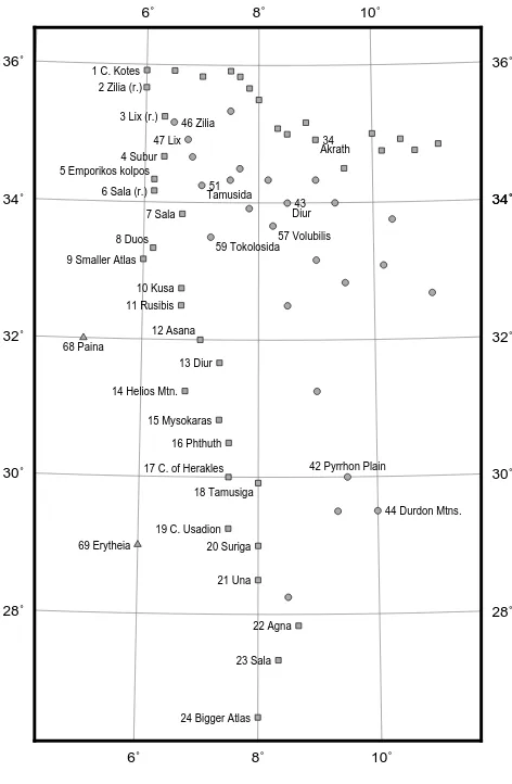
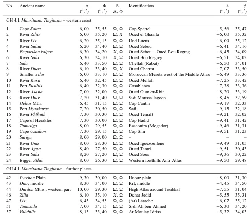
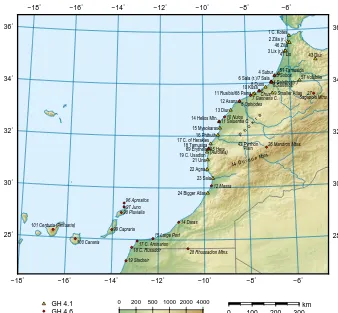
Figures 1 and 2 show the places of GH 4.1 Mauritania
Tingi-tana and of the western part of GH 4.6 Libya Interior based
on the Ptolemaic coordinates of . The Ptolemaic longi-tudes3and latitudes8of the considered places are given in Tables 1–3. Only the coordinate variant which showed to agree better with the actual position is specified; further val-ues are given in Sect. 4.
Mauritania Tingitana was a Roman province which
cor-responds to the northern part of Morocco. Pliny mentions
Volubilis (at Moulay Idriss) in the inland and Sala
(Chel-lah) at the western coast as the southernmost places in his description of Mauritania Tingitana (NH 5.1, division ac-cording to Bostock and Riley, 1855). These places are also given by Ptolemy (nos. 57 and 7). He describes the west-ern side of Mauritania Tingitana in GH 4.1.1–4 (nos. 1–24). (59) Tokolosida (Bled Takourart, S & G) in the inland near the coast was the southernmost place of the Roman territory (Forbiger, 1844, p. 878, fn. 14). Ptolemy’s description of the coast, however, contains several places which are situated further south. The southernmost (24) Bigger Atlas Moun-tain at8=26◦300 is situated about 7◦more southerly than
Volubilis and Sala. Ptolemy gives the south-eastern border
point of Mauritania Tingitana at8=26◦(GH 4.1.8). Con-sequently, Ptolemy’s Mauritania Tingitana ranges much fur-ther south than the Roman province (also Mannert, 1825, p. 473).
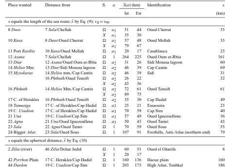
Ptolemy describes the coast of Libya Interior in GH 4.6.5– 7 (nos. 3–25). He states (4.6.4) that in the north its western side reaches up to the border point of Mauritania Tingitana (at8=26◦; see above), and this is in agreement with his
lat-itudes in Libya Interior, which are lower than those of
Mau-ritania Tingitana (see Figs. 1 and 2). The southernmost
6˚ 6˚ 8˚ 8˚ 10˚ 10˚ 28˚ 28˚ 30˚ 30˚ 32˚ 32˚
34˚ 34˚34˚
36˚ 36˚
1 C. Kotes
3 Lix (r.)
4 Subur
6 Sala (r.) 7 Sala
9 Smaller Atlas
10 Kusa 11 Rusibis
13 Diur
14 Helios Mtn.
15 Mysokaras 16 Phthuth
19 C. Usadion 20 Suriga
21 Una
22 Agna
23 Sala
24 Bigger Atlas
34
42 Pyrrhon Plain 43
44 Durdon Mtns. 46 Zilia
47 Lix
51
69 Erytheia 2 Zilia (r.)
5 Emporikos kolpos
8 Duos
12 Asana
17 C. of Herakles 18 Tamusiga Akrath Diur Tamusida 57 Volubilis 59 Tokolosida 68 Paina
Coast Inland Island
Figure 1.Ptolemy’s positions in GH 4.1 Mauritania Tingitana ().
2.2 Origination of coordinates
(M1) Cape Kotes/Cap Spartel and the (M3) Lix/Uad Lucus, the northernmost places at the western coast, have almost correct latitudes. They may be based on direct measurements at the place or in its vicinity (gnomon measurement). One kind of Ptolemy’s data sources may have been itineraries, but this is only likely for the region of the Roman province
Mau-ritania Tingitana, that is, for the places up to (M7) Sala. The
majority of Ptolemy’s positions at the coast is surely based on the information of the descriptions of sea routes along the coast. Known seafarings are the circumnavigation of Africa by Phoenicians under orders from Necho II (ca. 600 BC) and the voyages of Hanno (5th century BC), Polybios and Eu-doxos of Kyzikos (2nd century BC) along the African west-ern coast (e.g. Mauny, 1978; Keyser, 1993).
Travel reports contained journey times (see e.g. Hanno’s
Periplus), which were converted into distances by means of
assumptions about the speed. Either such estimated distances were available to Ptolemy or he himself converted journey times. Distance data may have been corrected for assumed
0˚ 0˚ 4˚ 4˚ 8˚ 8˚ 12˚ 12˚ 16˚ 16˚ 20˚ 20˚ 4˚ 4˚ 8˚ 8˚ 12˚ 12˚ 16˚ 16˚ 20˚ 20˚ 24˚ 24˚ 3 Subos
4 Salathos (r.)
11 Saluentia C. 12 Massa 13 Iarzeitha
14 Daras
18 C. Rusaddir 19 Stacheir 20 Port Perphosios
21 C. Katharon 22 Nias
24 Masitholos
25 Hypodromos Aithiopias 94 Kerne
95 Hera (Autolala)
97 Juno 98 Pluvialia
2 Hesperian Gulf 5 Salathos
6 Chusarios 7 Gannaria C.
8 Ophiodes 9 Begazei 10 Nuios
15 Large Port 16 Babiba 17 C. Arsinarion
23 Hesperu Keras 26 Mandron Mtns.
27 Sagapola Mtns.
28 Rhussadion Mtns.
29 Ochema Theon Mtn. 48 Autolalai 55 Malachath 57 Byntha 96 Aprositos 99 Capraria 100 Canaria 101 Centuria (Pintuaria)
Coast Inland Island/water
Figure 2.Ptolemy’s positions in the western part of GH 4.6 Libya Interior ().
errors. Ptolemy used to shorten distances in order to take into account bends of routes and anomalies of journeys, and in his examples a reduction of 13 is applied for each of these corrections (GH 1.2.4, 1.13). Differences of coordinates were derived based on Ptolemy’s setting
1◦=ˆ 500 st. (1)
(GH 1.7.1; st=stade) and further information or assump-tions about the direction of the route. Berggren and Jones (2000, 16–17) give an overview of Ptolemy’s procedures of the determination of coordinates.
According to GH 1.9.4 and 1.18.10, distances were speci-fied as the number of day-and-night seafarings (DN) and day distances (D) (cf. S & G, p. 105, fn. 117), and it applies
1 DN=2 D. (2)
Concerning the speed, Ptolemy says that one must trust the feasible daily shipping performance (GH 1.9.6). For-biger (1842, p. 550) and Kroll (1921) give overviews of the specifications of ancient authors about the speed of seafar-ings. Ptolemy, referring to other sources, mentions the speed (GH 1.9.4)
v∅=1000 st day−1, i.e. (3)
1 DN=1000 st, (4)
Table 1. Places of Ptolemy’s Geography at the African western coast as well as further inland places and their identifications, part 1. S.: source of3and8.
No. Ancient name 3 8 S. Identification λ φ
(◦,0) (◦,0) 3,8 (◦,0) (◦,0)
GH 4.1 Mauritania Tingitana – western coast
1 Cape Kotes 6, 00 35, 55 , Cap Spartel −5, 56 35, 47
2 River Zilia 6, 00 35, 20 ,X Oued el Gharifa −6, 00 35, 32
3 River Lix 6, 20 35, 15 , Uad Lucus −6, 09 35, 12
4 River Subur 6, 20 34, 40 , Oued Sebou −6, 41 34, 16
5 Emporikos kolpos 6, 30 34, 20 X, Oued Sebou – Oued Bou Regreg −6, 45 34, 09
6 River Sala 6, 30 34, 10 X, Oued Bou Regreg −6, 51 34, 02
7 Sala 6, 40 33, 50 , Chellah (Rabat) −6, 50 34, 01
8 River Duos 6, 10 33, 40 ,X Oued Cherrat −7, 07 33, 50
9 Smaller Atlas 6, 00 33, 10 , Moroccan Meseta west of the Middle Atlas −6, 49 33, 36
10 River Kusa 6, 40 32, 45 , Oued Mellah −7, 25 33, 42
11 Port Rusibis 6, 40 32, 30 , Casablanca −7, 38 33, 36
12 River Asana 7, 00 32, 00 , Oued Oum er-Rbia −8, 20 33, 19
13 River Diur 7, 20 31, 40 , Sidi Moussa lagoon −8, 45 32, 59
14 Helios Mtn. 6, 45 31, 15 , Cap Cantin −9, 17 32, 33
15 Port Mysokaras 7, 20 30, 50 , Safi −9, 15 32, 18
16 River Phthuth 7, 30 30, 30 , Oued Tensift −9, 21 32, 02
17 Cape of Herakles 7, 30 30, 00 , Cap Hadid −9, 41 31, 42
18 Tamusiga 8, 00 29, 55 , Essaouira (Mogador) −9, 46 31, 31
19 Cape Usadion 7, 30 29, 15 , Cap Sim −9, 51 31, 23
20 Suriga 8, 00 29, 00 , – – –
21 River Una 8, 00 28, 30 , Oued Iguezoullene −9, 49 31, 05
22 River Agna 8, 40 27, 50 , Oued Tamri −9, 51 30, 43
23 River Sala 8, 20 27, 20 , Oued Sous −9, 36 30, 22
24 Bigger Atlas 8, 00 26, 30 , Western foothills Anti-Atlas −9, 50 29, 48
GH 4.1 Mauritania Tingitana – further places
42 Pyrrhon Plain 9, 30 30, 00 , Haouz plain −8, 00 31, 30
43 Diur, middle 8, 30 34, 00 , Rif, middle −4, 45 34, 50
44 Durdon Mtns., western part 10, 00 29, 30 , High Atlas around Toubkal −7, 55 31, 04
46 Zilia 6, 10 35, 10 X, Dchar Jedid −5, 55 35, 31
47 Lix 6, 45 34, 55 , (At) Larache −6, 07 35, 12
51 Tamusida 7, 00 34, 15 , Sidi Ali ben Ahmed −6, 30 34, 20
57 Volubilis 8, 15 33, 40 , At Moulay Idriss −5, 32 34, 03
of the stade underlying ancient data is often unknown, which also applies to Ptolemy’s coordinates. Therefore two mea-sures of the stade are applied in the following, by which the major range of the measures is covered. These are the 18Rmi or Italian stade (Ist) according to G 7.7.4 and the Egyptian stade (Est) according to Hultsch (1882, p. 61):
1 Ist=185.2 m (5)
1 Est=157.5 m (6)
(Rmi=Roman mile, 1 Rmi=1.4815 km). The former was probably used by Polybios (Pothecary, 1995), who may have been a source for Ptolemy’s African coast, and both stades have been ascribed to Eratosthenes (see e.g. Pothe-cary, 1995). From Eq. (4) it follows that 1 DN=185/158 km, 1 D=93/79 km, 12D=46/39 km (Ist/Est).
3 Method of localisation
The unknown position of a place at the coast is determined uniquely by the distance from a known place and an indica-tion of the direcindica-tion along the coast. This informaindica-tion can be derived from the Ptolemaic coordinates so that they can be used for the localisation of the Ptolemaic places. In the fol-lowing, the reconstruction of the ancient distances (Sect. 3.1) and the accuracy of reconstructed distances (Sect. 3.2) are considered.
3.1 Determination of distances
Table 2. Places of Ptolemy’s Geography at the African western coast as well as further inland places and their identifications, part 2. S.: source of3and8.
No. Ancient name 3 8 S. Identification λ φ
(◦,0) (◦,0) 3,8 (◦,0) (◦,0)
GH 4.1 Mauritania Tingitana – further places (continuation)
59 Tokolosida 7, 10 33, 30 , Bled Takourart −5, 36 34, 02
61 Molochath 10, 10 33, 05 , – – –
62 Benta 9, 30 32, 55 ,X – – –
68 Island of Paina 5, 00 32, 00 , Island of Sidi Abderrahmane −7, 42 33, 35
69 Island of Erythia 6, 00 29, 00 , Mogador −9, 47 31, 30
– Mtn. Phokra – – – Southern part of the Moroccan Meseta −8, 00 32, 30
GH 4.6 Libya Interior – western coast
2 Hesperian Gulf 14, 00 4, 00 , Gulf of Guinea 4, 00 1, 30
3 River Subos 9, 00 25, 00 , Oued Sebou −6, 41 34, 16
4 River Salathos 9, 20 22, 00 , Oued Bou Regreg −6.51 34, 02
5 Salathos 9, 40 22, 00 , Chellah (Rabat) −6, 50 34, 01
6 River Chusarios 10, 00 21, 40 , Oued Mellah −7, 25 33, 42
7 Gannaria Capes 9, 30 20, 30 , Headlands near Dar Bouazza −7, 49 33, 32
8 River Ophiodes 10, 00 20, 00 , Oued Oum er-Rbia −8, 20 33, 19
9 Bagazei 11, 00 19, 00 , – – –
10 River Nuios 10, 00 18, 20 , Oualidia lagoon −9, 02 32, 44
11 Saluentia Capes 9, 30 17, 30 , Cap Cantin and a southern headland −9, 17 32, 33
12 River Massa 10, 30 16, 30 , Oued Massa −9, 40 30, 05
13 Iarzeitha 10, 00 15, 30 , – – –
14 River Daras 10, 00 15, 00 , Oued Draa −11, 07 28, 41
15 Large Port 10, 00 14, 00 , Khnifiss Lagoon −12, 14 28, 03
16 Babiba 10, 30 13, 00 , – – –
17 Cape Arsinarion 8, 00 12, 00 , Cap Juby −12, 55 27, 57
18 Cape Rusaddir 8, 30 11, 30 , Ras Afkir Oum M’Bark −13, 09 27, 42
19 River Stacheir 9, 30 11, 00 , Wad As Saguia al Hamra −13, 23 27, 11
20 Port of Perphosios 11, 00 10, 30 , – – –
21 Cape Katharon 12, 30 9, 30 , Cap Blanc −17, 03 20, 46
22 River Nias 13, 30 9, 00 , Senegal −16, 31 15, 56
23 Hesperu Keras 13, 00 8, 00 , Bight of Benin 3, 00 6, 20
24 River Masitholos 14, 00 6, 40 , Niger and Benue 6, 04 4, 17
25 Hypodromos Aithiopias 14, 00 5, 15 , – – –
direction (see e.g. Gyory et al., 2013). Ancient ships were driven by oar and sail; the speed was mainly influenced by the direction of the wind (Casson, 1971, 270–82). The pre-dominant wind at the northern African western coast is the northeastern trade wind. Its influence in this region can reach up to 35◦N (cf. Lockwood, 2005, p. 129, Fig. A79). A con-sideration of the current and the wind and of the speed of ancient journeys (Appendix A) shows that in ancient times the speed of a southward journey along the African western coast may have been about
vns=1300 st day−1 (7)
and the speed of a northward voyage
vsn=400 st day−1. (8)
For the localisation of Ptolemy’s places, the distances tween places are required. Assuming that the distance
be-tween two Ptolemaic positions (3i, 8i) and (3j, 8j) is based on a journey time, the reconstruction of this distance should take into account the underlying ancient conversion. The procedure applied is the stepwise conversion
3i, 8i, 3j, 8j7−→ ˆ1 s(◦)7−→ ˆ2 s(st)7−→3 1tˆ7−→ ˆ4 s(st)7−→ ˆ5 s(m) (9) (symbol7−→x : stepx of conversion). Since Ptolemy’s proce-dure of the determination of geographic coordinates is un-known in individual cases, in step 1 the spherical distance (Eq. B1) is calculated between the two positions, which can be regarded as a sound approximation. In step 2, Eq. (1) is used. In step 3, the estimated ancient journey time is 1tˆ= ˆs/v3.v3is the speed underlying the ancient conversion
Table 3. Places of Ptolemy’s Geography at the African western coast as well as further inland places and their identifications, part 3. S.: source of3and8.
No. Ancient name 3 8 S. Identification λ φ
(◦,0) (◦,0) 3,8 (◦,0) (◦,0)
GH 4.6 Libya Interior – further places
26 Mandron Mtns., middle 14, 00 19, 00 , Middle, High and Anti-Atlas, middle −7, 10 31, 31
27 Sagapola Mtns., middle 20, 20 22, 00 , In the Middle Atlas −4.55 33, 31
28 Rhussadion Mtns., middle 17, 00 11, 00 , Southwest of Jebel Ouarkziz −10, 43 27, 40
29 Ochema Theon Mtn. 19, 00 5, 00 , Mount Cameroon and Western High Plateau 10, 30 6, 30
30 Kapha Mtns., middle 27, 00 10, 30 ,X (See Sect. 4.6) – –
48 Autolalai 10, 00 23, 50 , – – –
55 Malachath 20, 20 20, 15 , – – –
57 Byntha 20, 15 21, 00 , – – –
94 Island of Kerne 5, 00 25, 40 , Herne −15, 47 23, 52
95 Island of Hera or Autolala 8, 00 23, 50 , Mogador −9, 47 31, 30
96 Island of Aprositos 1, 00 16, 00 , Alegranza −13, 31 29, 24
97 Island of Juno 1, 00 15, 15 , Graciosa −13, 31 29, 15
98 Island of Pluvialia 1, 00 14, 15 , Lanzarote −13, 38 29, 02
99 Island of Capraria 1, 00 12, 30 , Fuerteventura −14, 02 28, 22
100 Island of Canaria 1, 00 11, 00 , Gran Canaria −15, 36 27, 58
101 Island of Centuria (Pintuaria) 1, 00 10, 30 , Tenerife −16, 35 28, 17
ˆ
s=v41tˆ.v4 is the actual speed of the ancient journey for
whichvns(Eq. 7) is applied in the area of the Canary Current
and the trade wind. In step 5, the Italian and Egyptian stade (Eqs. 5 and 6) are used.
A special case of Eq. (9) is the equality of the an-cient assumed speed v3 and the actual ancient speed v4,
e.g. v3=v4=v∅. Then, the conversion corresponds to the direct conversion
3i, 8i, 3j, 8j7−→ ˆ1 s(◦)7−→ ˆ2 s(st)7−→ ˆ5 s(m) (10) of Ptolemy’s distance into a metric distance. Conversion Eq. (10) is applied to distances outside the area of the Ca-nary Current and the trade wind and to inland distances.
If further coastal places are given by Ptolemy between the two coastal sitesiandjbeing considered, the sum
ˆ sij=
j−1
X
k=i ˆ
sk,k+1 (11)
of the single distancessˆof the intermediate places has to be determined (order of the indices=order of the places).
The assumptions underlying the conversions according to Eqs. (9) and (10) may be wrong. Therefore, a correction fac-torais applied to distancessˆ if they reveal an obvious dis-tortion. Then, the calculated distance becomes
s(a)=as.ˆ (12)
Factorais determined from the data.
si,j orsji can be compared with the actual distances. In the case of two inland places, the spherical distance is de-termined; in the case of coastal places, the path length along
the coast is measured. The determination of actual distances was carried out by means of the Google Earth application (Google Inc., 2015).
3.2 Accuracy of Ptolemy’s distances
The distances derived from Ptolemy’s coordinates are pos-sibly adulterated by diverse errors, such as rounding errors of the distances and coordinates and unsuitable conversions of journey times into distances. In the following, possible er-rors are considered (Sect. 3.2.1), and Ptolemy’s distances are compared with distances given by Pliny in order to gain an insight into the reliability of the data (Sect. 3.2.2).
3.2.1 Errors of distances
The Ptolemaic coordinates3and8are rounded values. A few latitudes in GH 4.1 have a fraction of degree of 1112 so that Ptolemy used a resolution of121◦in these cases. The ma-jority of the coordinate values surely has a rougher resolu-tion (cf. Marx, 2011). An investigaresolu-tion of the propagaresolu-tion of the rounding errors of coordinates (Appendix B) shows that generally they may have caused distance errors up to 10 km (GH 4.1) or 30 km (GH 4.6), respectively.
Several large, partly systematic errors of the Ptolemaic dis-tances (see Sect. 5) are not explicable by rounding errors. The following types of adulterations of distances may have occurred.
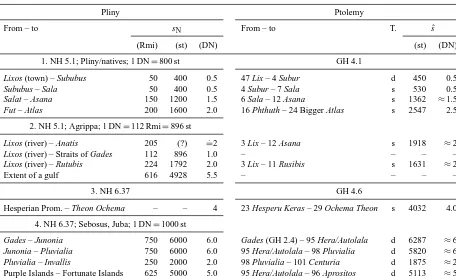
reso-Table 4.Comparison of Pliny’s distancessNand Ptolemy’s distancessˆderived from his coordinates by Eq. (9), steps 1 and 2, and Eq. (4). T.: type ofsˆ; d: direct spherical distance Eq. (B1); s: sum Eq. (11).
Pliny Ptolemy
From – to sN From – to T. sˆ
(Rmi) (st) (DN) (st) (DN)
1. NH 5.1; Pliny/natives; 1 DN=800 st GH 4.1
Lixos (town) – Sububus 50 400 0.5 47 Lix – 4 Subur d 450 0.5
Sububus – Sala 50 400 0.5 4 Subur – 7 Sala s 530 0.5
Salat – Asana 150 1200 1.5 6 Sala – 12 Asana s 1362 ≈1.5
Fut – Atlas 200 1600 2.0 16 Phthuth – 24 Bigger Atlas s 2547 2.5
2. NH 5.1; Agrippa; 1 DN=112 Rmi=896 st
Lixos (river) – Anatis 205 (?) =.2 3 Lix – 12 Asana s 1918 ≈2
Lixos (river) – Straits of Gades 112 896 1.0 – – – –
Lixos (river) – Rutubis 224 1792 2.0 3 Lix – 11 Rusibis s 1631 ≈2
Extent of a gulf 616 4928 5.5 – – – –
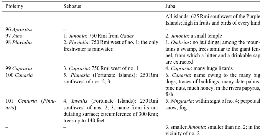
3. NH 6.37 GH 4.6
Hesperian Prom. – Theon Ochema – – 4 23 Hesperu Keras – 29 Ochema Theon s 4032 4.0
4. NH 6.37; Sebosus, Juba; 1 DN=1000 st
Gades – Junonia 750 6000 6.0 Gades (GH 2.4) – 95 Hera/Autolala d 6287 ≈6
Junonia – Pluvialia 750 6000 6.0 95 Hera/Autolala – 98 Pluvialia d 5820 ≈6
Pluvialia – Invallis 250 2000 2.0 98 Pluvialia – 101 Centuria d 1875 ≈2
Purple Islands – Fortunate Islands 625 5000 5.0 95 Hera/Autolala – 96 Aprositos d 5113 ≈5
lution was12D, errors up to14D were possible, i.e. about 20 km.
2. The speed of a sea voyage was influenced by currents and winds (Sect. 3.1), which was not taken into ac-count in the conversion of a journey time into a dis-tance. (a) If the assumed speed of a northward voyage was too large, the distance became too large. (b) If the assumed speed of a southward voyage was too small, the distance became too small. If a journey had the length s and if the actual speeds werevns (Eq. 7) and
vsn (Eq. 8), respectively, and provided thatv∅ (Eq. 3) was used for the conversion of the journey time into a distances0, then it follows thats0=v∅/vnss=0.77s
and s0=v∅/vsns=2.5s. Consequently, the distances
are significantly underestimated and overestimated. 3. The measurement units D and DN were confused
be-cause, for example, the distance was noted improperly as anx-day journey. (a) If a distance based onxD was mistaken forxDN, the distance became too large. (b) If a distance based onxDN was mistaken forxD, it be-came too small.
3.2.2 Comparison with Pliny’s distances
Pliny gives several distances between locations at the African western coast, see Table 4 (based on Winkler and König,
1993; Brodersen, 1996), which can be compared with Ptolemy’s distances. Müller (1902) and Spaul (1958, p. 6.2) make comparisons for the distances of NH 6.37 based on st and for the distances of NH 5.1 based on Rmi, respectively, revealing more or less significant differences from Ptolemy’s distances. Müller (1902), however, remarks that the distances are rough estimates based on journey times. This is taken into account in the following comparison.
Table 4 provides the sources of Pliny’s information, Pliny’s distancessNin Rmi and st (1 Rmi=8 st) and the
as-sumed original values in DN. The distances are grouped ac-cording to the assumed conversion between the units DN and st.
In group 1, the distances are multiples of 50 Rmi or of 400 st, so that they may be based on 1 DN=800 st. The resulting distances are multiples of 12DN and may be the original values. The distances of group 2 probably originate with Agrippa (Marcus Vipsanius Agrippa, ca. 64–12 BC; cf. translation Winkler and König, 1993). With one excep-tion, these distances are multiples of 56 Rmi (Klotz, 1931) or of 448 st. Thus, the ancient conversion may be based on 1 DN=900 st≈112 Rmi. The distances of group 4 are mul-tiples of 125 Rmi or 1000 st; they are probably based on 1 DN=1000 st.
In the case of sˆ47.4, the X variant is used, in the other
cases (Gades, GH 2.4.16: 3=5◦100, 8=36◦100). The
(M9) Smaller Atlas is not included in the sum Eq. (11) be-cause it does not exist at the coast (see Sect. 4.1) and was probably inserted by Ptolemy.
Pliny’s and Ptolemy’s distances can be used for an es-timation of the relation between the units st and DN that underlies Ptolemy’s distances. To do so, for each Ptole-maic distance sˆ (in st) of Table 4 the observation equation
ˆ
si+vi=c sNi is set up, wherei=1 . . . 11 is the index of the distance, sNi is Pliny’s distance expressed in DN, c is an unknown factor in st DN−1, andvi is a presumably ran-dom residual.cis determined by a least squares adjustment (see e.g. Böck, 1961; Baumann, 1993, 17–20); the result is 1008 st DN−1±21 st DN−1. Hence, the usual ancient rela-tion 1 DN=1000 st (Eq. 4) can be assumed for Ptolemy’s distances. Table 4 showssˆ expressed in DN. It reveals that Pliny’s and Ptolemy’s distances are identical in most cases. A few distances are reviewed in the following.
Ptolemy’s distance Fut–Atlas probably refers to the Anti-Atlas; see Sect. 4.3; Pliny, however, may refer to the High Atlas, so that his distance is shorter.
Pliny’s distance Lixos–Anatis cannot be derived from a journey time as the other distances. Spaul (1958, p. 6.2) assumes that 205=CCV is a corruption of 250=CCL. This is possible because the sum of Plinus’ three distances
Lixos–Sububus–Sala/Salat–Asana (=Anatis) also amounts
to 250 Rmi (the River Salat is near the town of Sala). The distance Hesperian Promontory–Theon Ochema is given directly by Pliny; it is also to be found in Peripl. 16. (Pliny gives, referring to Agrippa, a differing value of 10 DN in NH 5.1. Since, however, Agrippa places the Atlas in the middle of this distance, the information seems to be unreli-able and is not considered here.) Ptolemy’s distance is calcu-lated over the waypoints nos. L23–L25 and L29 and equals nearly exactly Pliny’s distance.
Consequently, the investigation shows that the ancient dis-tance data are consistent.
4 Ptolemy’s places at the African western coast
In the following, the places of GH 4.1 Mauritania Tingitana (Sects. 4.1–4.3) and GH 4.6 Libya Interior (Sects. 4.5–4.7) at the African western coast as well as further places are localised. In Sect. 4.4 the repetition of places of GH 4.1 in GH 4.6 is investigated.
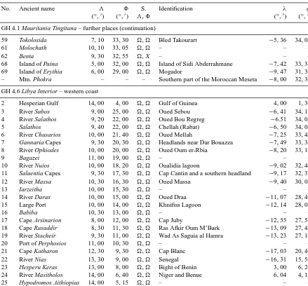
Tables 1–3 list the modern counterparts of the Ptolemaic places considered and their geographic longitudeλ(relative to Greenwich) and latitudeφ; Fig. 3 shows the northern po-sitions (no. M5 is omitted). Tables 5 and 6 give the locali-sations based on distances including these distances. Due to uncertainties and missing evidence, not all places can be lo-calised.
The sequence of the Ptolemaic places in the following sec-tions corresponds to that of their identification. Their mod-ern counterparts are indicated by bold text. Unless otherwise stated, Pliny’s information originates from NH 5.1.
4.1 Mauritania Tingitana part 1: up to the Asana
Firstly, the correction Eq. (12) is not used for distances s.ˆ The (9) Smaller Atlas is not included in the sum Eq. (11) of distances; cf. Sect. 3.2.2 and no. 9 below.
(1) Cape Kotes, (3) River Lix, (4) River Subur, (7) Sala, (47) Lix, (51) Tamusida, (57) Volubilis: these places are ei-ther known or consistently identified in the literature (e.g. in Spaul, 1958; S & G).
(43) Diur (mountains), middle: Spaul (1958, p. 8.8): Djebel Zerhoun; Lacroix (1998, p. 254): Rif. The Djebel Zer-houn is situated south of (57) Volubilis/Moulay Idriss, which contradicts Ptolemy’s position northeast of it. The Diur are the only mountains in the north of Mauritania Tingitana and are located between (57) Volubilis and (34) Akrath; the latter is situated at the northern coast (Fig. 1). This applies to the Rif.
(46) Zilia: Mannert (1825, p. 467), Forbiger (1844, p. 878, fn. 14), S & G: Asilah; Spaul (1958, p. 7.25), Aujac et al. (1969–2015, vol. 15, p. 80), Talbert (2000): Dchar Jedid. The identification of Zilia with Dchar Jedid 12 km northeast of Asilah is substantiated by inscriptions naming the town Zilil or Zili(s) (e.g. Aujac et al., 1969–2015).3of X fits better with that of (3) Zilia (: no. 46 6◦300).
(2) River Zilia: Mannert (1825, p. 468), Forbiger (1844, p. 869, fn. 82): small river at Asilah; Spaul (1958, p. 6.5): Oued Mharhar; Talbert (2000): Oued Khobs. Owing to the short distancesˆ46.2ofX(: no. 28=35◦400) and owing to
its name, River Zilia may be near (46) Zilia/Dchar Jedid as in the cases of (6) River Sala and (7) Sala as well as (3) River
Lix and (47) Lix. This is met by the Oued el Gharifa, whose
mouth is west of Dchar Jedid. Ruins and archaeological find-ings suggest a port at the mouth in the first century BC (Eu-zennat, 1976).
(6) River Sala: Mannert (1825, p. 472), Forbiger (1844, p. 868), Spaul (1958, p. 6.9), Talbert (2000), S & G: Oued Bou Regreg. The Sala is situated between the (4) Subur/Oued Sebou and (7) Sala/Chellah. There is only the Oued Bou Regreg.3of X is in better agreement with3of (7) Sala and3of (51) Tamusida than3of(6◦100).
0 200 500 1000 2000 4000
−18˚ −18˚
−16˚ −16˚
−14˚ −14˚
−12˚ −12˚
−10˚ −10˚
−8˚ −8˚
−6˚ −6˚
28˚ 28˚
30˚ 30˚
32˚ 32˚
34˚ 34˚
36˚ 36˚
0 100 200 300
km
3 Lix (r.)
9 Smaller Atlas 11 Rusibis/68 Paina
12 Asana 13 Diur
15 Mysokaras 16 Phthuth
21 Una 22 Agna 23 Sala
24 Bigger Atlas
42 Pyrrhon Plain
43 Diur
44 D u r d o n Mtns. 47 Lix
P h o k r a
3 Subos 4 Salathos(r.) 6
10 Nuios 11 Saluentia C.
12 Massa
14 Daras
19 Stacheir
27 Sagapola Mtns.
97 Juno 98 Pluvialia
101 Centuria (Pintuaria)
1 C. Kotes 2 Zilia (r.)
4 Subur 6 Sala (r.)/7 Sala
8 Duos 10 Kusa
14 Helios Mtn.
17 C. of Herakles 18 Tamusiga
19 C. Usadion
46 Zilia
51 Tamusida 57 Volubilis
69 Erytheia
5 Salathos Chus. 7 Gannaria C. 8 Ophiodes
15 Large Port 17 C. Arsinarion 18 C. Rusaddir
26 Mandron Mtns.
28 Rhussadion Mtns. 95 Hera (Autolala)
96 Aprositos
99 Capraria
100 Canaria
GH 4.1 GH 4.6
Figure 3.Identified northern places in GH 4.1 Mauritania Tingitana (upright) and GH 4.6 Libya Interior (italic).
bays so that they do not seem to be identical. Alternatively, Ptolemy’s or Pliny’s information may either be erroneous or both refer to a bay which reaches approximately from the Uad Lucus (Lix) to the Oued Bou Regreg (Sala). If Ptolemy refers to a coastal point,3ofXis to be preferred in agree-ment with no. 6 (: 6◦100).
(12) River Asana: Mannert (1825, p. 473), Forbiger (1844, p. 869), S & G: Oued Oum er-Rbia. The rivers clos-est to sˆ712 are the Oued Oum er-Rbia and the Oued Tensift (s=. 160 km, 350 km). The Oued Oum er-Rbia is chosen in agreement with the mentioned literature. Forbiger (1844) states that the ancient name of the river can be recognised in the name of the town Azamur (Azemmour) at the river mouth.
From the ratio ofsˆ712and the correspondingsfollows the correction factor
a1=0.654, (13)
which is the average of the results from Ist and Est. a1 is
applied in Eq. (12) up to no. 12.
(8) River Duos: Spaul (1958, p. 6.11): Oued Cherrat; S & G: Oued Mellah.s7,8(a1) of(no. 88=33◦200) is met
by the Oued Mellah and the Oued Nefifikh (s=. 60 km), but then there would be no large river which satisfies the position of the (10) Kusa between the (8) Duos and the (12) Asana.
Therefore, the Oued Cherrat is chosen, which is in accor-dance withs7,8(a1) ofX.
(10) River Kusa: Spaul (1958, p. 6.11): Oued Nefifikh; S & G: Oued Sous. For the (8) Duos, 8 of X has to be applied; see no. 8 above. The Oued Mellah and the Oued Oum er-Rbia are the rivers closest tos8,10(a1) (s=. 33 km,
130 km). Since the latter is equated with the (12) Asana, the
Kusa is the Oued Mellah.
(9) Smaller Atlas Mountain: between the (8) Duou/Oued Cherrat and the (10) Kusa/Oued Mellah there are no moun-tains at the coast or in its vicinity. South-east of the mouth of the Oued Cherrat, however, parts of the Moroccan Meseta west of the Middle Atlas are close to the coast. Ptolemy probably features these high plains and mountains wrongly as a coastal point far to the west.
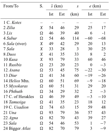
Table 5.Localisation of the places of GH 4.1 Mauritania Tingitana. S.: source of the Ptolemaic position;a: correction factor;s(a): corrected Ptolemaic distance Eq. (12);s: actual distance; Ist, Est: based on the Italian/Egyptian stade.
Place wanted Distance from S. a s(a) (km) Identification s
Ist Est (km)
sequals the length of the sea route;sˆby Eq. (9);v4=vns
8 Duos 7 Sala/Chellah a1 51 44 Oued Cherrat 33
X a1 35 30
10 Kusa 8 Duos/Oued Cherrat a1 57 48 Oued Mellah 33
X a1 79 67
11 Port Rusibis 10 Kusa/Oued Mellah a1 20 17 Casablanca 23
12 Asana 7 Sala/Chellah 1 264 225 Oued Oum er-Rbia 161
13 Diur 12 Asana/Oued Oum er-Rbia a2 31 26 Sidi Moussa lagoon 60
14 Helios Mtn. 13 Diur/Sidi Moussa lagoon a2 46 39 Cap Cantin 69
15 Mysokaras 14 Helios mtn./Cap Cantin a2 46 39 Safi 31
16 Phthuth/Oued Tensift a2 26 22 32
X a2 43 36
16 Phthuth 14 Helios Mtn./Cap Cantin a2 72 61 Oued Tensift 61
X a2 89 75
17 C. of Herakles 16 Phthuth/Oued Tensift a2 35 30 Cap Hadid 49
18 Tamusiga 17 C. of Herakles/Cap Hadid a3 25 21 Essaouira 23
19 C. Usadion 17 C. of Herakles/Cap Hadid a3 70 59 Cap Sim 40
21 Una 19 C. Usadion/Cap Sim a3 57 49 Oued Iguezoullene 36
22 Agna 21 Una/Oued Iguezoullene a3 50 43 Oued Tamri 43
23 Sala 22 Agna/Oued Tamri 1 70 59 Oued Sous 53
24 Bigger Atlas 23 Sala/Oued Sous 1 107 91 Foothills, Anti-Atlas (northern end) 79
sequals the spherical distance;sˆby Eq. (10)
2 Zilia (river) 46 Zilia/Dchar Jedid 1 60 51 Oued el Gharifa 8
X 1 20 17
42 Pyrrhon Plain 17 C. Herakles/Cap Hadid 1 160 136 Haouz plain 160
44 Durdon 19 C. Usadion/Cap Sim 1 203 173 High Atlas, Toubkal 186
Table 6. Localisation of the places of GH 4.6 Libya Interior. S.: source of the Ptolemaic position;a: correction factor;s(a): corrected Ptolemaic distance Eq. (12);s: actual length of the sea route; Ist, Est: based on the Italian/Egyptian stade.
Place wanted Distance from S. a s(a) (km) Identification s
Ist Est (km)
ˆ
sby Eq. (9),v4=vns
7 Gannaria C. 6 Chusarios/Oued Mellah a4 47 40 C. near Dar Bouazza 43
8 Ophiodes 7 Gannaria C./c. at Dar Bouazza a4 26 22 Oued Oum er-Rbia 55
10 Nuios 8 Ophiodes/Oum er-Rbia a4 95 81 Oualidia lagoon 96
11 Saluentia C./Cap Cantin a4 36 31 Oualidia lagoon 32
12 Massa 11 Saluentia C./Cap Cantin 1 167 142 Oued Massa 305
14 Daras 12 Massa/Oued Massa 1 194 165 Oued Draa 212
15 Large Port 14 Daras/Oued Draa 1 120 102 Khnifiss Lagoon 132
17 C. Arsinarion 14 Daras/Oued Draa 1 572 486 Cap Juby 200
18 C. Rusaddir 17 C. Arsinarion/Cap Juby 1 84 72 Ras Afkir Oum M’Bark 39
X 1 190 162
19 Stacheir 18 C. Rusaddir/Ras Afkir Oum M’Bark 1 133 113 Wad As Saguia al Hamra 61
X 1 118 100
ˆ
sby Eq. (10)
very unlikely in view of that of the other ancient data. Pliny’s two distances may originate from rough specifications as 2 DN; see Sect. 3.2.2. Third, 205 Rmi may be a corruption of 250; three other distances given by Pliny yield the sum of 250 Rmi for this distance; see Sect. 3.2.2. In contrast to the usual identification Mazagan, Casablanca is consistent with Ptolemy’s positioning and also with his distances10,11(a1).
(68) Island of Paina: 8 of Paina equals that of the (12) Asana/Oum Er-Rbia, and the island is positioned at a large distance to the coast. This is met by the Madeira archipelago. Ptolemy, however, often positions islands much too far from the coast (see e.g. England and Italy in Kleineberg et al., 2012; Marx and Kleineberg, 2012). Owing to its8, Paina is probably situated near the (12) Asana/Oum Er-Rbia. There exists the island of Sidi Abderrahmane, which is only 100more northern than the river mouth.
4.2 Mauritania Tingitana part 2: up to the Cape of
Herakles
The sumsˆ1224from the Asana/Oued Oum er-Rbia to the Big-ger Atlas amounts to 866/737 km (Ist/Est). The BigBig-ger Atlas must correspond to the foothills of the High Atlas or of the Anti-Atlas near the coast. The resulting actual distances are significantly smaller thansˆ1224. Since the Anti-Atlas yields a smaller difference, it is preferred to the High Atlas. (Gos-selin (1798–1813), Spaul (1958) and Lacroix (1998) also as-sume that the Bigger Atlas is further south than the High At-las.) The foothills of the Anti-Atlas (at 29◦480N) begin at s=. 472 km. The ratios/sˆyields the correction factor
a2=0.588 (14)
(average based on Ist and Est), which is used in Eq. (12) in the following.
(13) River Diur: Spaul (1958, p. 6.12): Oualidia lagoon. Ats12,13(a2) there is no river; the nearest river is the Oued
Tensift ats=. 190 km. Possibly, the Diur refers to a lagoon, which was taken for a river. The Oualidia lagoon is situated ats=. 97 km, but the Sidi Moussa lagoon ats=. 60 km fits better withs12,13(a2).
(14) Helios Mountain: Mannert (1825, p. 475), Forbiger (1844, p. 867), Spaul (1958, p. 6.10), S & G: Cap Cantin (Beddouza); Talbert (2000, Soloeis): Cap Spartel. The cape
Helios Mountain is also named Soloeis (S & G, p. 383, fn. 12;
Peripl. 3). The only cape in the vicinity ofs13,14(a2) is Cap
Cantin.
(16) River Phthuth: Gosselin (1798–1813, p. 125), Man-nert (1825, p. 476), Forbiger (1844, p. 869), Spaul (1958, p. 6.16): Oued Tensift. The Oued Tensift is situated in ac-cordance with the lower values ofs1614(a2), which is followed
by only a few short rivers.8 offits better than8of X (30◦150).
(15) Port Mysokaras: Gosselin (1798–1813, p. 125), Mannert (1825, p. 476), Spaul (1958, p. 6.14): Safi. Today, Safi is the largest town between (14) Helios Mountain/Cap
Cantin and the (16) Phthuth/Oued Tensift. It is consistent withs14,15(a2) ands15,16(a2) (; see no. 16 above).
(17) Cape of Herakles: Mannert (1825, p. 476), Forbiger (1844, p. 867), Spaul (1958, p. 6.13): cape/peninsula of Mo-gador; S & G: Cap Hadid. The only large cape in the vicinity ofs16,17(a2) (; see no. 16 above) is Cap Hadid. The cape
is marked by the nearby mountain of Jebel Hadid, which is visible from the sea (cf. Arlett, 1836, p. 289).
(42) Pyrrhon Plain: Spaul (1958, p. 7.19): Haouz plain; Talbert (2000): possibly Gharb plain. The Pyrrhon Plain is east of the (17) Cape of Herakles/Cap Hadid. The Haouz plain is almost east of Cap Hadid and in accordance with ˆ
s17,42.
4.3 Mauritania Tingitana part 3: up to the Bigger Atlas
The sumsˆ1724 from the Cape of Herakles/Cap Hadid to the Bigger Atlas is 553/470 km (Ist/Est), but the actual dis-tance to the foothills of the Anti-Atlas (cf. Sect. 4.2) is only s=. 240 km. This yields the new correction factor
a3=0.469 (15)
(average based on Ist and Est), which is used in Eq. (12). (18) Tamusiga: Gosselin (1798–1813, p. 125): at the Oued Ksob (near Essaouira); Mannert (1825, p. 476), S & G: Mo-gador (Essaouira). Essaouira is consistent with s17,18(a3).
Excavations revealed that there was a Phoenician settlement in the seventh century BC (Culican, 1991, p. 543).
(19) Cape Usadion: Gosselin (1798–1813, p. 125), Spaul (1958, p. 6.13): Cap Ghir; Mannert (1825, p. 476), Forbiger (1844, p. 867), S & G (p. 385, fn. 13): Cap Sim (Osem). In the vicinity ofs1917(a3) there are Cap Sim and Cap Tafelney
(s=. 40 km, 73 km). The latter would cause a lack of space for the places up to the Bigger Atlas, so that Cap Sim is chosen.
Mountain Phokra: the Phokra reaches from the (9) Smaller Atlas/Moroccan Meseta west of the Middle Atlas to (19) Cape Usadion/Cap Sim (GH 4.1.12). In this region the Moroccan Meseta is situated at some distance from the coast so that the Phokra corresponds to the southern part of the Moroccan Meseta.
Soloeis and north of the River Masathat, which probably
cor-respond to Cap Cantin and the Oued Massa (e.g. Winkler and König, 1993, p. 120) as well as to Ptolemy’s (14) Helios Mountain and (L12) Massa (see Sect. 4.2, no. 14; Sect. 4.6, no. 12). In conclusion, the Autololes were situated between Cap Cantin and the High Atlas. The only islands in this re-gion are at Essaouira (Mogador). Thus, these are the Purple Islands, and Erytheia refers to Mogador, the largest of them. It has been suggested that the Purple Islands are the Canary Islands (e.g. Hennig, 1944, p. 45), where orchil lichen may have been used for dyeing. Müller (1902), however, points out that Pomponius Mela and Pliny mention seashells as the origin of the Gaetulian Purple (Mela: “Those coasts [of the Nigritae and the Gaetuli] are very famous for purple and murex – the most effective dyeing materials”, Chorography 3.104, Romer, 1998; Pliny: “. . . all the rocks of Gaetulia are searched for the murex and the purple”).
(21) River Una: Gosselin (1798–1813, p. 125): Oued Sous; Mannert (1825, p. 476): Oued Iguezoullene (Iguzul); Spaul (1958, p. 6.15): Oued Massa. The only large river in the vicinity ofs2119(a3) is the Oued Iguezoullene.
(22) River Agna: Spaul (1958, p. 6.15): Oued Adoudou; S & G: Oued Tamri (Beni-Tamer). The largest river in the vicinity ofs21,22(a3) is the Oued Tamri.
(23) River Sala: Mannert (1825, p. 477): Oued Tamri (Beni-Tamer); Spaul (1958, p. 6.15): Oued Noun; S & G: Oued Tamraght. There are only very small rivers at s22,23(a3). The Oued Sous, however, is consistent withsˆ22,23
(without factora).
(24) Bigger Atlas Mountain: Gosselin (1798–1813, p. 125), Spaul (1958, p. 6.13): Cap Noun/Cap Draa; Lacroix (1998, p. 175): Anti-Atlas; S & G (p. 385, fn. 14): Cap Ghir. Owing to the fitting distance sˆ22,23 (see no. 23 above), no
correction factorais applied tosˆ23,24. Approximately at this
distance the foothills of the Anti-Atlas begin.
(44) Durdon Mountains, western part: Spaul (1958, p. 8.8): Toubkal; Lacroix (1998, p. 166): High Atlas; S & G: Sidi-bel-Abbes. The Durdon Mountains are almost east of (19) Cape Usadion/Cap Sim. In an easterly direction and at a distance ofsˆ19,44, the western parts of the High Atlas are
situated. Approximately atsˆ19,44, Toubkal is located, which
is the highest peak in the Atlas Mountains.
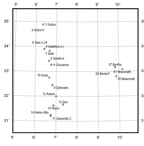
4.4 Identical places
If Ptolemy used different data sources for GH 4.1
Maurita-nia Tingitana and GH 4.6 Libya Interior, which contained
different place names and distances, he might have not no-ticed identical places. Gosselin (1798–1813, p. 129) assumes that the following four coastal places of GH 4.1 also appear in GH 4.6 with similar names and in the same order:
– (M4) River Subur and (L3) River Subos,
– (M6) River Sala and (L4) River Salathos,
5˚ 5˚
6˚ 6˚
7˚ 7˚
8˚ 8˚
9˚ 9˚
10˚ 10˚
31˚ 31˚
32˚ 32˚
33˚ 33˚
34˚ 34˚
35˚ 35˚
3 Subos
6 Chusarios
4 Subur
6 Sala (r.)
7 Sala
10 Kusa
14 Helios Mtn.
61 Molochath 62 Benta
12 Asana
13 Diur
4 Salathos (r.) 5 Salathos
11 Saluentia C.
55 Malachath 57 Byntha
8 Ophiodes
10 Nuios
GH 4.1 GH 4.6
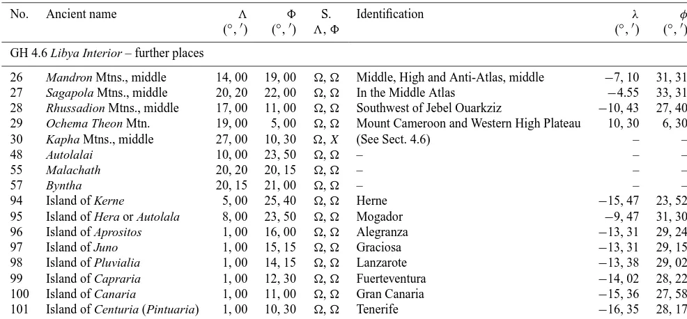
Figure 4.Presumably identical places of GH 4.1 Mauritania Tin-gitana (upright) and GH 4.6 Libya Interior (italic). The positions of GH 4.6 are geometrically transformed by means of an adjustment of a transformation of coordinates.
– (M7) Sala and (L5) Salathos,
– (M10) River Kusa and (L6) River Chusarios.
Gosselin (1798–1813) assumes a few further repetitions of coastal places. Since no explanations are obvious for them, they are not considered here (also declined by Pinkerton, 1817, p. 702, fn. *).
There are three further pairs of places which have similar names in GH 4.1 and GH 4.6 and similar relative positions with respect to the assumed duplicated places:
– (M61) Molochath and (L55) Malachath,
– (M62) Benta and (L57) Byntha,
– (M14) Helios Mountain (Soloeis) and (L11) Saluentia Capes.
The first two pairs are inland towns. Nos. M14 and L11 are both equated with the promontory Soloeis of Peripl. 3 (e.g. Forbiger, 1844, p. 867; Gosselin, 1798–1813, p. 130).
Consequently, identity is assumed for seven pairs of places here. This hypothesis is extended at the end of Sect. 4.5. The similar positions of the presumably duplicated places are il-lustrated in Fig. 4 by means of a transformation of coordi-nates (see below), which positions the places of GH 4.6 in the vicinity of the places of GH 4.1.
the coordinates are shifted. Additionally, differences in the scale may exist between GH 4.1 and GH 4.6, for example, because their data sources are based on different determina-tions and conversions of journey times and because Ptolemy scaled distances. Furthermore, the directions of the identical stretches of the coast may differ so that a small rotation is present. The described systematic differences of coordinates between GH 4.1 and GH 4.6 are modelled by means of a two-dimensional transformation of coordinates. Its parame-ters are estimated by means of a least squares adjustment. It is assumed that the size of the remaining differences af-ter the transformation is explicable by the uncertainty of the coordinates. This hypothesis is tested by means of a statisti-cal test (Appendix C). As a result, the hypothesis is accepted, and consequently the identity of the places considered can be assumed. Figure 4 shows remaining deviations between the positions of GH 4.1 and the transformed positions of GH 4.6.
4.5 Libya Interior part 1: up to the Saluentia Capes
(3) River Subos, (4) River Salathos, (5) Salathos, (6) River
Chusarios, (11) Saluentia Capes: for these places, identity
with places in GH 4.1 is assumed according to Sect. 4.4 so that their localisations are adopted (see Table 2). On no. 11, also see below.
(27) Sagapola Mountains, middle: the (3) Subos/Oued Sebou has its source in these mountains (GH 4.6.8); the source of the Oued Sebou is in the Middle Atlas.
(94) Island of Kerne: Spaul (1958, p. 8.10): one of the Ca-nary Islands. According to Peripl. 8, 10, Kerne has a circum-ference of 5 st≈1 km and the journey time from the Pillars of Herakles (at the Strait of Gibraltar) to Kerne corresponds to that from Karchedon (Carthage) to the Pillars. It is often identified as Herne in the Bahia de Rio de Oro (e.g. Bunbury, 1879, p. 324, following Carl Müller), which roughly meets the information (the length of the sea route around Herne is ca. 2.5 km). Pliny states (NH 6.36) that according to Polybios
Kerne is situated 8 st from the coast opposite the mountain Atlas. The former is in accordance with Herne, whereas the
latter is not. Ptolemy makes the same mistake by positioning
Kerne and the (M24) Bigger Atlas at similar latitudes (25◦400
and 26◦300).
(48) Autolalai: it is the northernmost town at the coast of Libya Interior south of Ptolemy’s Mauritania Tingitana, which can be related to the Autololes according to its name. Ptolemy seems to follow the information that the Autololes are situated south of Mauritania Tingitana (cf. NH 5.1).
(95) Island of Hera or Autolala: Gosselin (1798–1813, p. 160): Fédal; Mannert (1825, p. 630): Madeira; Müller (1902): Mogador. The island is also called Juno or Junonia, and Ptolemy assigns a further (97) Juno to the Fortunate Is-lands. Ptolemy places Hera at the same latitude as the town of (48) Autolalai, i.e. as the Autololes. Ptolemy may re-fer to the Purple Islands (also Forbiger, 1844, p. 892) be-cause Pliny, referring to Juba, places them opposite the
Au-tololes (NH 6.37). Hence, Hera is Mogador as Ptolemy’s (M69) Erytheia (see Sect. 4.3, no. 69). Furthermore, Ptolemy may use Sebosus’ information that Junonia is situated 750 Rmi=6000 Ist from Gades (NH 6.37; Cádiz) because this is consistent with Ptolemy’s distance (Table 4; Müller, 1902, also identifies Ptolemy’s island as Sebosus’ Junonia).
Junonia is one of the Canary Islands; see Sect. 6. Juba assigns Junonia to the Fortunate Islands, whereas Sebosus does not.
Possibly, this brought Ptolemy to assume two islands, so that he assigned (95) Hera to the Purple Islands and (97) Juno to the Fortunate Islands.
The adjustment of a transformation of coordinates in Ap-pendix C revealed a scaling factor of about 2 between the lat-itudes of GH 4.1 and 4.6 from the (3) Subos to the (11)
Salu-entia Capes. Since Ptolemy’s coast runs almost southward,
the factor 12 can be applied to the distances of GH 4.6 as a correction. Additionally, the distortion of the distances of GH 4.1 described bya1anda2(Eqs. 13, 14) has to be
con-sidered. By means of their average of 0.621, the correction factor for Eq. (12) becomes
a4=0.5·0.621=0.311. (16)
(7) Gannaria Capes: according to the name (Greek akra), Ptolemy refers to more than one cape, which is usually not taken into account (see e.g. Forbiger, 1844, p. 880; S & G). The most distinctive cape nears6,7(a4) is the cape at Dar
Bouazza. South and north of it, there are a small peninsula and a small headland, which may have been referred to. Al-ternatively, the cape at Casablanca, 20 km northeast of Dar Bouazza, is included additionally.
(8) River Ophiodes: the first large river with respect to s7,8(a4) is the Oued Oum er-Rbia with acceptables.
(10) River Nuios: no rivers exist between the (8) Ophiodes/Oued Oum er-Rbia and the (11)
Saluen-tia Capes/Cap Cantin. The Oualidia lagoon, however, is
situated consistently withs108 (a4) ands10,11(a4), which may
have been mistaken for a river.
(11) Saluentia Capes: the name suggests more than one cape. One of them corresponds to the (M14) Helios Moun-tain/Cap Cantin (see Sects. 4.2, 4.4, no. M14). Three kilo-metres south-south-east of it, there is a small headland with a height of 50 m, which is possibly referred to. Also, Cap de Safi 20 km south of Cap Cantin comes into consideration.
The localisation of the places reveals that there are two further places in GH 4.1 and GH 4.6, which refer to the same location or region:
– (M12) Asana and (L8) Ophiodes,
– (M13) Diur and (L10) Nuios.
4.6 Libya Interior part 2: up to the Stacheir
(12) River Massa: Forbiger (1844, p. 882), S & G: Oued Massa. The name of the river suggests the Oued Massa. In accordance with Ptolemy’s information, it is situated further south than the (11) Saluentia Capes/Cap Cantin and has its source in the (26) Mandron Mountains/Atlas (see no. 26 be-low).sˆ11,12, however, is much too small. Probably, Ptolemy
had no accurate information about this very long distance. Owing to the large distance between nos. 11 and 12, these places may originate from different data sources. Therefore, the correction factora4(Eq. 16) applied to the northern
tances is not used in Eq. (12) for the following southern dis-tances.
(14) River Daras: Forbiger (1844, p. 882): Río de Oro; S & G: Oued Draa. The Daras probably corresponds to the
Darat mentioned by Pliny (e.g. Forbiger, 1844, p. 881),
where crocodiles were found. There exist two short rivers (s=. 175 km, 200 km) in the vicinity ofsˆ1214; the name, how-ever, argues for the Oued Draa ats=. 212 km. Furthermore, crocodiles existed there; cf. de Smet (1998).
(30) Kapha Mountains, middle: S & G (p. 447, fn. 182): a part of the High Atlas. The (14) Daras/Oued Draa has its source in these mountains (GH 4.6.9). The confluences of the Draa rise in the middle part of the High Atlas; before it reaches lower areas, the Draa flows through a valley be-tween the Anti-Atlas and Jbel Saghro. A part of these three mountains may correspond to the Kapha Mountains and may have been regarded as the location of the source of the Daras. Ptolemy’s position far to the south is explicable by the south-easterly direction of the Draa from the coast, which may have been assumed for the entire course of the river.8ofX fits better than that of(10◦).
(96–101) Fortunate Islands: Ptolemy’s first and northern-most island (96) Aprositos has a somewhat smaller8than the (12) Massa/Oued Massa. This is met by the Canary Islands. Fuerteventura is visible from the mainland (Keyser, 1993) so that this island must have been known. On the individual is-lands, see Sect. 6.
(17) Cape Arsinarion: since this cape is situated in the latitudes of the Fortunate Islands/Canary Islands, it is Cap Juby.
(15) Large Port: the port may have been at a river mouth; in the vicinity ofsˆ14,15, however, there are only very short
rivers. The Khnifiss Lagoon (Sebkha Tazra) is situated in compliance with sˆ14,15, which may have been suitable for
a port. Accordingly, Arlett (1836, p. 298) assumes that the Portuguese port Porto Consado shown on old maps of this region was at the lagoon. The name Large Port may have arisen from the extent of the lagoon.
(26) Mandron Mountains, middle: S & G: High Atlas. The five rivers nos. 4, 6, 8, 10 and 12 have their sources in the Mandron Mountains (GH 4.6.8). The locations of the actual sources are the following: (4) Salathos/Oued Bou Regreg: Middle Atlas; (6) Chusarios/Oued Mellah: at
Khouribga, nearly halfway between the coast and Middle Atlas; (8) Ophiodes/Oued Oum er-Rbia: Middle Atlas; and (12) Massa/Oued Massa: Anti-Atlas. Thus, it can be assumed that the Mandron Mountains are the entire mountain range of the Middle, High and Anti-Atlas, whose middle is in the High Atlas. A part of the Mandron Mountains is already given in GH 4.1 by the (M24) Bigger Atlas. The (10) Nuius refers to the Oualidia lagoon; the source of this supposed river was assumed to be in easterly mountains, i.e. in the
Mandron Mountains.
(28) Rhussadion Mountains, middle: Mannert (1825, p. 525): Cap Blanc; S & G (p. 447, fn. 180): possibly near Cape Ghir. The source of the (19) Stacheir/Wad As Saguia al Hamra is in the Rhussadion Mountains (GH 4.6.8). This river has tributaries in the highland southwest of Jebel Ouarkziz. (18) Cape Rusaddir: according to Ptolemy, this cape is situated west of the (28) Rhussadion Mountains/highland southwest of Jebel Ouarkziz. This is in agreement with Ras Afkir Oum M’Bark.sˆ17,18, however, does not support this
identification;sˆ of fits better than that of X (X: no. 17 8=13◦).
(19) River Stacheir: according toX, the river mouth is east of (18) Cape Rusaddir/Ras Afkir Oum M’Bark, which is not given by the direction of the coast. According to, the river is further south than no. 18 so that it may be the Wad As Saguia al Hamra. It is the largest and longest wa-tercourse in Western Sahara (Hughes et al., 1992, p. 90). This identification, however, is not substantiated bysˆ18,19.
4.7 Libya Interior part 3: up to the Ochema Theon
(29) Ochema Theon Mountain: according to Peripl. 16, 17, flames and torrents of fire were observed on this mountain so that it is probably a volcano. Burton (1862) identifies it as Mount Cameroon, probably for the first time, which was the only volcano then active in the area under investigation (cf. Hennig, 1944, 86–95). Forbiger (1844, p. 880, fn. 18) assumes that the appearance of fire was not caused by a vol-cano but by people, which, however, does not explain the mentioned torrents of fire. Mount Cameroon at 4◦130 lati-tude nearly fits8=5◦of the Ochema Theon. The source of the (24) Masitholos/Niger (see no. 24 below) is situated at the Ochema Theon (GH 4.6.9). The Niger has a tributary, the Benue, which has its sources in the Western High Plateau north-east of Mount Cameroon. Hence, Ptolemy refers to Mount Cameroon and the Western High Plateau, which explains why he does not place the Ochema Theon directly at the coast.
is Ptolemy’s repetition of a part of Mauritania Tingitana in GH 4.6, which diminished the available space. Additionally, the coast is shortened through its wrong direction from north-west to south-east. This direction corresponds to the ancient idea of the western side of Africa (e.g. G 2.5.15, Mela 1.20; cf. Berger, 1903, p. 400; Romer, 1998, p. 39, fn. 19), which Ptolemy probably makes use of. Consequently, the following localisations are mostly not based on distances.
(22) River Nias: Mannert (1825, p. 526), Forbiger (1844, p. 882), S & G: Senegal. Following this suggestion, the Nias is assumed to be the Senegal.
Like the Nias, the Chretes in Peripl. 9 and the
Bambo-tus in NH 5.1 are also equated with the Senegal (e.g. S & G,
p. 447, fn. 177; Winkler and König, 1993, p. 352). The equat-ing of the Chretes with the Senegal is questionable. The text of Peripl. 9,10 reads: “Sailing from there [Kerne/Herne], we crossed a river called Chretes, and reached a bay, which contained three islands [. . . ] After a day’s sail from here, we arrived at the end of the bay, which was overhung by some very great mountains. [. . . ] Leaving from there, we ar-rived at another large, broad river teeming with crocodiles and hippopotamuses.” The passage suggests that the three islands are not more than a few days’ journey distant from
Kerne. This is only met by the three islands at Cap d’Arguin,
which are about 450 km from Kerne, or by Tidra and its sur-rounding islands. The Chretes is further north and cannot be the Senegal. The mentioned bay is probably the section be-tween Cap d’Arguin (16◦320W/20◦330N) and Cap Tafarit (16◦160W/20◦080N), and the islands are therefore at Cap d’Arguin. The actual distance of 55 km between both capes is in accordance with the given journey time if it is rounded up to 1 D. The Chretes may refer to the Bay of Lévrier (16◦540W/20◦530N) and the salt marshes at its shores, which
may have been taken for a river mouth. The mentioned moun-tains possibly correspond to Cap Tafarit, which has an extent of about 1 km and, in contrast to its vicinity at ground level, a height of about 40 m. The mentioned second river may be the Senegal (also Forbiger, 1844, p. 882; Lendering, 1998– 2014), where there are crocodiles today (e.g. Hughes et al., 1992, p. 48).
(21) Cape Katharon: the most significant cape be-tween the (19) Stacheir/Wad As Saguia al Hamra and the (22) Nias/Senegal is Cap Blanc.
(23) Hesperu Keras (“Horn of the West”): Mannert (1825, p. 525), Forbiger (1844, p. 881), Bunbury (1879, p. 325, fn. 6): Cap-Vert. A place of the same name is to be found in
Peripl. 14 and NH 5.1, 6.35, 36. According to the Periplus,
it is a bay, which is identified as the Bight of Benin (e.g. Winkler and König, 1993, p. 121). Later authors, including Pliny and Ptolemy, transformed it into a cape (cf. Bunbury, 1879). According to Peripl. 14, 16, an island in the bay is a 4-day journey from the (29) Ochema Theon/Mount Cameroon. This journey time is also specified in NH 6.35 for the dis-tance Hesperu Keras–Ochema Theon so that Pliny and prob-ably also Ptolemy actually refer to the bay. The journey time
is consistent with Ptolemy’ssˆ2329(over nos. 23–25 and 29; see Sect. 3.2.2, Table 4) and corresponds to about 740/630 km. The Bight of Benin is situated at this distance.
(24) River Masitholos: Mannert (1825, p. 532), For-biger (1844, p. 882): Gambia; Lacroix (1998, p. 264): Volta; S & G: Oued Massa. The river has to be between the (23) Hesperu Keras/Bight of Benin and the (29) Ochema
Theon/Mount Cameroon. The Niger Delta extends over this
area. The source of the Masitholos is in the (29) Ochema
Theon/Western High Plateau (GH 4.6.9), which is met by the
river Benue, a tributary of the Niger.
(2) Hesperian Gulf: Lacroix (1998, p. 263): Gulf of Guinea. The Hesperian Gulf lies south of the (24)
Masitho-los/Niger Delta. It may be the Gulf of Guinea. The places
from the (19) Stacheir/Wad As Saguia al Hamra southwards, however, are also situated at the gulf (GH 4.6.7). This prob-ably follows from a wrong idea of the direction of the coast; cf. Fig. 2. Thus, in the strict sense, Ptolemy’s Hesperian Gulf refers to the Atlantic Ocean west and south of Western Africa.
5 Errors of Ptolemy’s data
Based on the localisations of the Ptolemaic places described in Sect. 4, the errors of the Ptolemaic distances (Sect. 5.1) and coordinates (Sect. 5.2) are investigated.
5.1 Distances
In order to illustrate the errors of the Ptolemaic distancess,ˆ the direct conversion of Eq. (10) is used for their derivation from the Ptolemaic coordinates. If identifications are missing between two places, the sum Eq. (11) is used; no. M9 is, however, excluded from it. Tables 7 and 8 give the deviation
e= ˆs−s (17)
between sˆ and the actual distance s along the coast. The strongly distorted distances south of the (L12) Stacheir are not considered; on their errors, see Sect. 4.7.
A fewsˆhave small deviationseof some kilometres. They are explicable by rounding errors of distances and coordi-nates, which may have caused distance errors of about 20 km (GH 4.1) or 30 km (GH 4.6); cf. Sect. 3.2.1. Several devia-tions, however, are significantly larger.