www.nat-hazards-earth-syst-sci.net/8/539/2008/ © Author(s) 2008. This work is distributed under the Creative Commons Attribution 3.0 License.
and Earth
System Sciences
Spatial variability and potential impacts of climate change on flood
and debris flow hazard zone mapping and implications for risk
management
H. Staffler1, R. Pollinger2, A. Zischg3,4, and P. Mani5
1Department of Civil Protection, Autonomous Province of Bolzano South Tyrol, Bolzano, Italy 2Department of Hydraulic Engineering, Autonomous Province of Bolzano South Tyrol, Bolzano, Italy 3Abenis AG, Chur, Switzerland
4Abenis Alpinexpert srl, Bolzano, Italy 5geo7 AG, Berne, Switzerland
Received: 18 February 2008 – Revised: 7 May 2008 – Accepted: 13 May 2008 – Published: 12 June 2008
Abstract. The main goals of this study were to identify the alpine torrent catchments that are sensitive to climatic changes and to assess the robustness of the methods for the elaboration of flood and debris flow hazard zone maps to spe-cific effects of climate changes. In this study, a procedure for the identification and localization of torrent catchments in which the climate scenarios will modify the hazard situ-ation was developed. In two case studies, the impacts of a potential increase of precipitation intensities to the delimited hazard zones were studied.
The identification and localization of the torrent and river catchments, where unfavourable changes in the hazard situa-tion occur, could eliminate speculative and unnecessary mea-sures against the impacts of climate changes like a general enlargement of hazard zones or a general over dimensioning of protection structures for the whole territory. The results showed a high spatial variability of the sensitivity of catch-ments to climate changes. In sensitive catchcatch-ments, the sed-iment management in alpine torrents will meet future chal-lenges due to a higher rate for sediment removal from reten-tion basins. The case studies showed a remarkable increase of the areas affected by floods and debris flow when consid-ering possible future precipitation intensities in hazard map-ping. But, the calculated increase in extent of future hazard zones lay within the uncertainty of the methods used today for the delimitation of the hazard zones. Thus, the consider-ation of the uncertainties laying in the methods for the
elab-Correspondence to: A. Zischg
oration of hazard zone maps in the torrent and river catch-ments sensitive to climate changes would provide a useful instrument for the consideration of potential future climate conditions. The study demonstrated that weak points in pro-tection structures in future will become more important in risk management activities.
1 Introduction
The assessment of dangerous processes and the delimitation of hazard zones is a fundamental task in risk analysis and risk management. In general, the assessment and evaluation of geomorphologic processes and hazards could be made us-ing the reconstruction of historical processes (backward rected indication) or using simulation models (forward di-rected indication, Kienholz et al., 2004). In practice, both approaches mostly are combined. Usually, the hazard as-sessment is made for the actual state of the studied system (e.g. torrent catchment, landslide area, etc.). Natural hazards are described by the process intensity of a given design event with a certain reoccurrence interval (e.g. 30, 100, 300 years). The actual system status is described by the statistical system behaviour of the last decades.
of the past geomorphologic processes also named as “silent witnesses” and statistical analyses of time series for assess-ing actual processes will increasassess-ingly be subjected to uncer-tainties. Past observation data (e.g. precipitation data series) could probably not represent the future system status. As a consequence, the statistically described natural hazard situa-tion and the reoccurrence intervals of design flood discharges or design parameters for the planning of hydraulic protection structures could only partially be valid under future climate conditions (e.g. Caspary 1996, 2004, Caspary and Bardossy 1995, Bardossy and Pakosch 2005, Frei et al. 2006, Katzen-berger 2004, Hennegriff et al. 2006).
But, most of the decisions made in risk prevention have to be made for a period of almost 30–50 years. E.g. hazard zone maps do influence land use planning over a long period. In Austria or in Switzerland, some of the hazard zone maps made in the 1980ies are still now valid documents for land use planning. Technical construction measures such as river dams or flood retention basins have an average lifespan of almost 50 years. In practice, today’s decisions for long-term risk management activities such as the planning of technical protection measures do not consider the future system status but are reactions after damaging events.
Since a few years, the Autonomous Province of Bolzano – South Tyrol, Italy is beginning to elaborate hazard zone maps. Because of the high relevance of the elaborated haz-ard zone maps for land use planning and the planning of risk reduction measures, the institutions responsible for the elaboration of these decision bases are interested to know, if these documents will be valid also under future climate con-ditions. Thus, this study aims not at making a contribution to the quantitative assessment of the impacts of climate change to natural hazards. But, the main goal of this study was to as-sess the robustness or sensitivity of the commonly used pro-cedures for the delimitation of flood and debris flow hazard zone maps to climatic changes. The question should be an-swered, if, where and how the practices for hazard mapping and risk management must be adapted to potential impacts of climatic changes.
The focus of this case study lied not on the exact repre-sentation of the environmental systems by means of detailed process and climate models but on the resulting differences of the hazard assessment representing different climate con-ditions. Thus, only the potential impacts of climate change to specific input parameters should be studied.
In this study, a procedure
– for identifying the alpine torrent catchments that are sensitive to climatic changes and
– for assessing the robustness of the methods for the elab-oration of flood and debris flow hazard zone maps to specific effects of climate changes
should be developed.
The targeted time frame for the assessment of the potential effects of climate changes to the flood risk situation in the Autonomous Province of Bolzano - South Tyrol is the sec-ond half of the 21st century (2050–2100). The results of the procedure should lead to formulate recommendations for the adaptation of risk management practices to specific effects of climate changes.
Natural hazards are mostly defined as natural conditions or phenomena which cause undesired consequences for per-sons, settlements, infrastructures and goods. In some defini-tions, natural hazards are described as natural geomorpho-logic processes that are considered as hazards only in in-tersection with human activities. These processes are char-acterized as the probability of occurrence of a potentially damaging phenomenon (United Nations, 2004). The phys-ical process itself is characterized by the parameters inten-sity/magnitude and occurrence probability. The risk resulting from natural hazards is defined as a quantifying function of the probability of occurrence of a dangerous process and the related degree of damage. The latter is specified by the dam-age potential and the vulnerability of the endangered object (Fuchs et al., 2007).
Ri,j =pSi·AOj·pOj,Si·vOj,Si (1)
According to the definition of United Nations (2004), the specifications for the probability of the defined scenario (pSi), the monetary value of the object affected by this
sce-nario (AOj), the probability of exposure of objectj to sce-narioi(pOj,Si), and the vulnerability of objectj in depen-dence on scenarioi(vOj,Si)are required for the quantifica-tion of risk (Ri,j).
The methods for the description and characterization of the natural hazards in the Alps are based on the intensity and frequency of events. Thus, the concept of the legally binding hazard maps is based on the return period and the intensity of processes. Usually, natural hazards are described in hazard maps by threshold classes of the process intensity for differ-ent design evdiffer-ents with a given reoccurrence interval (e.g. 30, 100, 300 years, resp. 200 years for rivers with engineering measures). The relative consequences for the land use and the corresponding legally binding restrictions are also based on this concept. Risk analyses are made on the basis of this concept of hazard maps. Furthermore, the planning and sign of permanent countermeasures are based on specific de-sign events with a legally defined return period and the re-lated process intensity.
Because of these practices in risk management, the deduc-tion of the most critical factors for hazard assessment un-der changing environmental conditions is relatively obvious: At least for natural hazards related to precipitation, the most relevant changes in the environmental parameters due to cli-matic changes are to be expected in the intensity/frequency relation of precipitation events (rainfall, snowfall). Indirect effects are shifts in altitude levels due to rising temperatures, e.g. rising of the altitude of the limit between snowfall and rainfall or rising of the lower boundary of permafrost zones. Seasonal and regional changes in precipitation patterns are to be expected as follows: In Autumn, extreme values for daily precipitations are expected to increase by 10% in the Northern Alps and by 20% in the Southern Alps. In winter and spring, an increase between 0% and 20% is expected for both regions (KOHS, 2007). Brunetti et al. (2001) observed a trend for an increase in frequency of extreme precipitation events in Northeastern Italy. Under the most unfavourable conditions, a 100-year event of today could in the future become a 20-year event (Frei et al., 2006). Similar trends were calculated for the rivers Donau, Enz, Kocher and Alp in South West Germany (Caspary, 2004). Caspary (2004) un-derlines that the discharge regimes of these rivers show sta-tistical instationarities in their time series because of the rela-tive accumulation of extreme events since the 1990ies. E.g. a discharge event with a reoccurrence interval of 100 years in the reference period 1932–1976 of the river Enz at the gauge of Pforzheim equals a discharge event with a reoccurrence interval of 30 years in the reference period 1932–2002. Re-markably increases in runoff and discharge volumes were also computed for the Lavanttal region (Austria) when con-sidering possible effects of climate changes (Regional Office of Carinthia, Department of Water Economy 2008).
An indirect effect of the increase of mean temperature is the rising altitude level for the limit between rainfall and snowfall. In areas of the Northern Alps below 1500 m a.s.l., an increase of flood peaks is expected in winter due to higher soil water contents, the rising of the rainfall/snowfall limit level and due to an increased liquid precipitation (KOHS, 2007). In the pre-Alpine regions, the increase of precipitation in winter and the rising of the snowfall limit will have conse-quences for the activities of landslides in winter and spring. The increase in saturation leads to an increase in landslide activity and to an increase in sediment load in alpine torrent catchments (Sch¨adler et al., 2007). Due to the rising altitude level of glacier retreat and permafrost degradation, the sedi-ment transport in the areas between approximately 2300 and 2800 m a.s.l. and with relevant bed load source areas in this altitude level is expected to increase (KOHS, 2007). Since in these areas more precipitation will fall in liquid form, this trend is expected to be remarkably.
Discussions with experts for hazard zone mapping in dif-ferent workshops resulted, that the following climatological parameters used in the assessment of flood and debris flow hazards are at most sensitive to climate changes
– Intensity of precipitation
– Frequency of precipitation of a certain inten-sity/magnitude
Other parameters such as the altitude of snowfall limit, the al-titude of snowmelt level, the antecedent precipitation, the re-treating of glaciers or the degradation of permafrost are con-sidered only in a generalized way in the common procedures for hazard zone mapping. Certain parameters needed for haz-ard mapping are assumed as worst case scenarios, e.g. the as-sumption that the altitude of the limit between snowfall and rainfall during extreme precipitation events is higher than the mountain crests and all precipitation contributes to runoff. Thus, in this study only the impacts of a potential increase in the intensities of extreme precipitation events (>50 mm/d) to the delimitation of hazard zones were analyzed. On the basis of a literature review, a possible increase in the precip-itation intensity of at maximum of 20% for all design events as indicated by Frei et al. (2006) for the Southern Alps was assumed for this sensitivity analysis. The assumption is con-sistent with the observed trend in the reduction of the return period between extreme precipitation events in Northeastern Italy (Brunetti et al., 2001). Due to the main focus on the ro-bustness of the procedures for hazard zone mapping, in this study no downscaling procedures from global and regional climate models to the local conditions were followed. It was assumed that the effects of an increase in precipitation inten-sity of less than 20% are laying within the uncertainties of the procedures for the delimitation of hazard zones. There-fore, it was expected that an increase of less than 20% will not show remarkably effects to the increase in the extent of the hazard zones.
2 Method
The study was made in three main steps. Firstly, the sen-sitivity of the alpine torrent catchments to climate changes was analysed qualitatively on the regional scale. Secondly, the possible effects of climate changes to the delimitation of flood hazard zones were analysed in a case study. In an-other case study, the possible effects of climate changes to the delimitation of debris flow hazard zones were analysed. Finally, conclusions and recommendations for the adaptation of the risk management practices have been elaborated on the basis of the results of the previous three steps.
2.1 Identification and localisation of alpine torrent and river catchments sensitive to climate changes
Fig. 1. Study area in the Autonomous Province of Bolzano South Tyrol, Italy.
described above will modify the hazard situation (flood and debris flows).
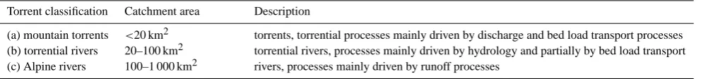
The first step of the procedure was to match the environ-mental parameters relevant for hazard assessment on the re-gional scale with the existing spatial datasets. On the basis of the identified parameters and the existing datasets, an ap-proach for the classification of the torrent catchments of dif-ferent dimensions and for the qualitative assessment of the sensitivity of the catchments to assumed climatic changes was developed. The catchments were classified into three catchment classes: mountain torrents, torrential rivers and alpine rivers (see Table 1). The results of the study were the delineated catchments classified by the sensitivity to the changes in the selected environmental parameters.
The activities of flood and debris flow processes in alpine torrents are mainly driven by the discharge, the sediment budget and the sediment transport capacity. The sediment transport capacity is influenced either by short precipitation events (thunderstorms) or by longer precipitation events. Be-cause of the steepness of alpine torrent catchments, the hy-drological characteristics in the runoff formation are less im-portant. In torrential river catchments both the sediment bud-get and the hydrological characteristics in the runoff forma-tion are important. In river catchments, the hydrological characteristics in the runoff formation are important. Be-cause of the larger catchment area, the characteristics of the sediment budget are evened.
The sensitivity analysis was made in a pilot area of the Au-tonomous Province of Bolzano – South Tyrol (Fig. 1). The delimitation of the torrent and river catchments was made on the basis of the classification scheme for public water-courses of the Autonomous Province of Bolzano. The basic assumptions for potential future climate conditions were the following:
– The daily mean temperatures in summer and winter are increasing (Heimann and Sept, 2000; OcCC, 2007) – The mean sum of precipitation in summer is decreasing
or remains constant
– The mean sum of precipitation in winter is increasing (OcCC, 2007)
– The intensity and frequency of short extreme rainfall events in summer and autumn is increasing (Christensen and Christensen, 2003)
It was assumed that the following factors are varying spa-tially and are relevant for the sensitivity of the torrent catch-ments to climate changes:
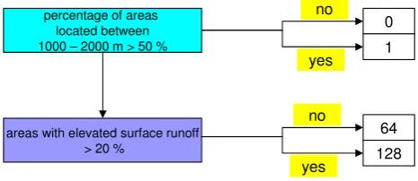
– Percentage of areas located between 1000 and 2000 m a.s.l.: It is expected that the snow cover in these areas will be reduced and the frequency of combined snowmelt/rainfall events will increase (KOHS, 2006). A threshold value of 50% of these areas respective to the total catchment area was chosen. This information layer was extracted from the digital elevation model. The value for this parameter was found by a statisti-cal analysis of the catchments assessed as sensitive to climatic changes by local experts.
Table 1. Classification of alpine torrent catchments.
Torrent classification Catchment area Description
(a) mountain torrents <20 km2 torrents, torrential processes mainly driven by discharge and bed load transport processes (b) torrential rivers 20–100 km2 torrential rivers, processes mainly driven by hydrology and partially by bed load transport (c) Alpine rivers 100–1 000 km2 rivers, processes mainly driven by runoff processes
flows and from the landslide inventory of the Geological Survey of the Autonomous Province of Bolzano (IFFI – Italian National Landslide Inventory).
– Available bed load source areas: The bed load sediment budget of alpine torrents depends on the quantity of bed load source areas available for sediment transport and the sediment transport capacity. The sensitivity of tor-rent activity against climate changes increases with a higher proportion of bed load source areas respective to the total catchment area. During the elaboration of the hazard index map for debris flow, the available bed load source areas were computed and weighted on the ba-sis of the relevance for torrential processes (geo7 2006, Heinimann et al. 1998). For this analysis, a minimum threshold for the weighted bed load source areas per catchment was used for the identification of sensitive catchments. This information layer was extracted from the dataset of the hazard index map for debris flows. – Permafrost degradation and glacier retreat areas:
Per-mafrost influences the hydrology and stability of steep scree slopes, since ice-rich permafrost acts as a barrier to groundwater percolation and can imply local satura-tion within non-frozen debris (Zimmermann and Hae-berli, 1992). Permafrost thawing in non-consolidated material leads to an increase of pore water pressure and a loss of cohesion (Harris et al., 2001). The disappear-ance of ground ice bodies in scree slopes leaves caverns and destabilizes parts of these disintegrated slope areas. With accelerated permafrost thawing, the susceptibil-ity of these slope areas for landslide and debris flows and the triggered volumes is expected to rise (Zimmer-mann et al., 1997; Rebetez et al., 1997). Catchments were classified as sensitive, if more than 30% of the to-tal catchment area is subjected to permafrost degrada-tion. The value for this parameter was found by a sta-tistical analysis of the catchments assessed as sensitive to climatic changes by local experts. This information layer was created by modelling the permafrost distribu-tion of 1850, 1990 and 2100 (after St¨otter, 1994; Zischg, 2007). The difference between the datasets of the per-mafrost distribution of 1850 and 2100 was classified as permafrost degradation areas. Because of a lack in mul-titemporal glacier datasets, glacier retreat areas were not considered in this study.
percentage of areas located between 1000 – 2000 m > 50 %
characteristics of bed load source areas:
Recent deposits older deposits > 30 %
landslides > 30 %
available bed load source areas >= 125 / km2
permafrost degradation areas >= 30 %
0 1
2 4 8
16 32
64 128 no
yes
no
yes
no
yes
Fig. 2. Decision tree for the identification and localisation of alpine torrent catchments sensitive against climate changes.
– Areas with elevated surface runoff: Areas with reduced water storage capacities increase the surface runoff. The sensitivity of torrential rivers and rivers to climate changes increases with a higher proportion of areas with reduced water storage capacities respective to the total catchments area. This information layer was created by modelling the Topoindex after Beven et al. (1995) un-der consiun-deration of the geological permeability. This index describes the susceptibility of areas for saturated surface runoff.
percentage of areas located between 1000 – 2000 m > 50 %
characteristics of bed load source areas:
Recent deposits older deposits > 30 %
landslides > 30 %
available bed load source areas >= 125 / km2
areas with elevated surface runoff > 20 %
0 1 2 4 8 16 32 64 128 no yes no yes no yes
Fig. 3. Decision tree for the identification and localisation of tor-rential river catchments sensitive against climate changes.
percentage of areas located between 1000 – 2000 m > 50 %
areas with elevated surface runoff > 20 %
0 1 64 128 no yes no yes
Fig. 4. Decision tree for the identification and localisation of alpine river catchments sensitive against climate changes.
2.2 Potential impacts of climate changes to the delimitation of flood hazard zones, case study Rio Ridanna/Mareiter Bach
In this part of the study, the sensitivity of the common meth-ods and procedures for the delimitation of flood hazard zone maps to climate changes was analysed. The focus of this case study lied not on the exact representation of the environmen-tal systems by means of detailed process and climate models but on testing the robustness of the methods and procedures for hazard mapping to changes of the needed input parame-ters. On the basis of a literature review, a possible increase of 20% of the precipitation intensity for each design event (re-occurrence interval 30, 100, 200 years) was assumed for this sensitivity analysis. The hazard induced by bed load trans-port and overbank sedimentation was not considered.
The Rio Ridanna/Mareiter Bach basin lies in the north of the Autonomous Province of Bolzano – South Tyrol (Fig. 8). The river endangers parts of the Vipiteno/Sterzing Basin and
c a tc h m e n t t y p e a v a ila b le b e d lo a d s o u rc e a re a s d is c h a rg e s u m m e r d is c h a rg e w in te r b e d lo a d t ra n s p o rt c a p a c it y s u m m e r b e d lo a d t ra n s p o rt c a p a c it y w in te r fr e q u e n c y o f s m a ll e v e n ts fr e q u e n c y o f m e d iu m e v e n ts fr e q u e n c y o f e x tr e m e e v e n ts WB01 (082) WB02 (146) WB03 (098) WB04 (162) WB05 (084) WB06 (148) WB07 (100) WB08 (164) WB09 (088) WB10 (152) WB11 (104) WB12 (168) WB13 (083) WB14 (147) WB15 (099) WB16 (163) WB17 (085) WB18 (149) WB19 (101) WB20 (165) WB21 (089) WB22 (153) WB23 (105) WB24 (169) decrease increase remarkable increase unaltered inexistent
Fig. 5. Synthesis of the considered potential impacts of climate changes to alpine torrent catchments (WB01 to WB24). The iden-tification number of the torrent catchment type resulting from the decision tree is shown in the brackets
the city of Vipiteno/Sterzing and confluences with the Is-arco/Eisack River. The catchment area is 210 km2. This study area is a representative example for an alpine river with hazard potential for settlements.
For the assessment of the present flood hazard situation of the Rio Ridanna/Mareiter Bach for the Vipiteno/Sterzing basin, this procedure was followed:
– statistical analyses of the precipitation time series of the measurement stations in the study area and calculation of the characteristics of precipitation events relevant for the hazard scenarios with a return period of 30, 100 and 200 years,
– preparation and calibration of the rainfall-runoff model,
c a tc h m e n t t y p e a v a ila b le b e d lo a d s o u rc e a re a s d is c h a rg e s u m m e r d is c h a rg e w in te r b e d lo a d t ra n s p o rt c a p a c it y s u m m e r b e d lo a d t ra n s p o rt c a p a c it y w in te r fr e q u e n c y o f s m a ll e v e n ts fr e q u e n c y o f m e d iu m e v e n ts fr e q u e n c y o f e x tr e m e e v e n ts WF01 (082) WF02 (146) WF03 (098) WF04 (162) WF05 (084) WF06 (148) WF07 (100) WF08 (164) WF09 (088) WF10 (152) WF11 (104) WF12 (168) WF13 (083) WF14 (147) WF15 (099) WF16 (163) WF17 (085) WF18 (149) WF19 (101) WF20 (165) WF21 (089) WF22 (153) WF23 (105) WF24 (169) decrease increase remarkable increase unaltered
Fig. 6. Synthesis of the considered potential impacts of climate changes to torrential river catchments (WF01 to WF24). The identi-fication number of the torrential river catchment type resulting from the decision tree is shown in the brackets.
– delimitation of the hazard zone map,
– analysis of the exposed buildings.
The results of the procedures described above were the haz-ard maps describing the hazhaz-ard situation on the basis of sim-plified assumptions representing present (scenario 2000) and future (2050–2100) climate conditions (scenario +20%). The main focus laid more on the comparison of the two hazard situations rather than on the single hazard assessment itself.
The statistical analysis of the precipitation time series was based on the measurement stations of Ridanna/Ridnaun (31 measurement years). In the analysis, precipitation events with a duration of 24 h were considered (Scherer and Mazzo-rana, 2007). The calculated precipitation values of a rainfall event with a duration of 24 hours representing reoccurrence intervals of 30, 100 and 200 years are shown in Table 2. For the representation of the design precipitation events under
c a tc h m e n t t y p e a v a ila b le b e d lo a d s o u rc e a re a s d is c h a rg e s u m m e r d is c h a rg e w in te r b e d lo a d t ra n s p o rt c a p a c it y s u m m e r b e d lo a d t ra n s p o rt c a p a c it y w in te r fr e q u e n c y o f s m a ll e v e n ts fr e q u e n c y o f m e d iu m e v e n ts fr e q u e n c y o f e x tr e m e e v e n ts FL01 (064) FL02 (128) FL03 (065) FL04 (129) decrease increase remarkable increase unaltered
Fig. 7. Synthesis of the considered potential impacts of climate changes to alpine river catchments (FL01 to FL04). The identifica-tion number of the river catchment type resulting from the decision tree is shown in the brackets.
Fig. 8. Localisation and delimitation of the Rio Ridanna/Mareiter Bach catchment.
Table 2. Calculated rainfall and runoff values for relevant return periods and different climate conditions (Scherer and Mazzorana, 2007).
return period of a rainfall event, duration 24 h Ntot(precipitation) [mm] Qmax(discharge) at confluence [m
3/s]
scenario 2000 scenario +20% scenario 2000 scenario +20%
30 years 106.6 127.9 212.5 299.6
100 years 125.7 150.8 272.6 383.9
200 years 136.6 164.0 333.3 431.8
Fig. 9. Localisation and delimitation of the Rio Cen-gles/Tschenglser Bach catchment.
al. (1998). The resulting hazard maps were overlayed with the buildings in the settlement areas. Thus, the changes in the hazard situation were demonstrated by the changes in the extent of the hazard zones and by the changes in the num-ber of the endangered buildings. The related damages were estimated by multiplying the number of endangered build-ings with a mean value of expected losses per building. This value represents a combination of the terms AOj and vOj,Si
in Eq. 1. For residential buildings, a mean value of expected losses of about C 45 000 was used, and for industry buildings a mean value of expected losses of about C 80 000 was used for the estimation of the potential damages regarding flood events.
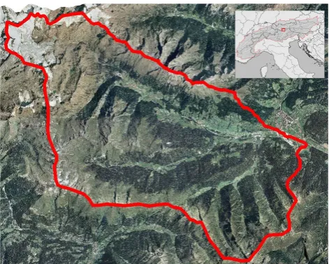
2.3 Potential impacts of climate changes to the delimita-tion of debris flow hazard zones, case study Rio Cen-gles/Tschenglser Bach
The Rio Cengles/Tschenglser Bach torrent lies in the western part of the Autonomous Province of Bolzano South Tyrol. The Rio Cengles/Tschenglser Bach torrent confluences with the river Adige/Etsch. The catchment area is 11 km2. This study area is a representative example for systematized alpine torrents eroding older deposits in permafrost degradation
ar-eas (Fig. 9). The hazard potential of these kinds of torrents is mainly driven by the sediment mobilization and bedload transport capacity because of the unlimited sediment source areas. The sediment transport capacity is driven by the runoff and the discharge. The upper catchment area is characterized by the disappearance of a small glacier in the recent years and the erosion of oversteepened scree slopes supposed to permafrost degradation. The Rio Cengles/Tschenglser Bach is systematised by sediment retention basins and check dams. For the assessment of the actual situation of debris flow hazards in the Rio Cengles/Tschenglser Bach catchment, the following procedure was followed (IPP 2007):
– characteristics of precipitation events relevant for the hazard scenarios with a return period of 30, 100 and 300 years,
– preparation and verification of the rainfall-runoff model,
– simulation of the bed load transport in the transit area and in the sediment retention basins,
– simulation of the debris flow processes in the deposition area for each return period,
– delimitation of the hazard zone map,
– analysis of the exposed buildings.
climate conditions (scenario +20%), 20% of these precipi-tation values were added (IPP, 2007; Table 5). For the dis-charge prediction, the rainfall-runoff model Hec-HMS and the SCS-approach was used and adapted to the catchment characteristics of the Rio Cengles/Tschenglser Bach. The calibration of the model was made with well documented debris flow events (Gostner, 2002). For the simulation of the bed load transport in the transit area and in the sediment retention basins, the simulation model DAMBRK of the US National Weather Service was used. For the simulation of the debris flow processes in the runout area, the simulation model Flow-2D (O’Brian, 2001) was used. The flood hazard zone map was made following the guidelines for hazard zone mapping of the Autonomous Province of Bolzano – South Tyrol (Autonome Provinz Bozen – S¨udtirol, 2006) and Hein-imann et al. (1998).
3 Results
3.1 Identification and localisation of alpine torrent and river catchments sensitive to climate changes
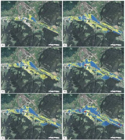
The main results of the procedure were the classification of the torrent catchments into different reaction typologies and the classification into different sensitivity typologies (Fig. 10). The datasets could be queried under different as-pects. Figure 10 show a high spatial variability of the sen-sitivity of the torrent catchments to specific impacts of cli-matic changes. This underlines the observations made in the Ecrin massif (Jomelli et al., 2004; Jomelli et al., 2007). The procedure was made also for torrential river and river catch-ments. The results showed that the runoff of nearly all tor-rent catchments is expected to increase in summer (Fig. 10a). The runoff in winter is expected to increase only in torrent catchments having a high percentage of their total surface area below 2000 m (Fig. 10b). The bed load transport in summer is expected to increase in high mountain areas and is expected to decrease in catchments at submontane levels (Fig. 10c). In some catchments eroding younger deposits (weathered material), a decrease in extreme events is high-lighted (Fig. 10f). This is consistent with the observations of Jomelli et al. (2004), Jomelli et al. (2007) and Stoffel and Beniston (2006). In some catchments eroding older de-posits an increase in extreme events is pointed out (Fig. 10f). This seems consistent with the observations of Rebetez et al. (1997). The bed load transport in winter increases in a few mountain torrent catchments and does not change in the most catchments (Fig. 10d). The frequency of small scale debris flow and sediment transport processes is expected to increase in most of the torrent catchments (Fig. 10e).
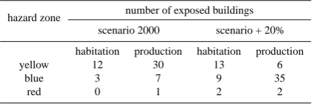
Table 3. Number of buildings endangered by flood processes of the Rio Ridanna/Mareiter Bach and per hazard zones.
hazard zone number of exposed buildings scenario 2000 scenario + 20% habitation production habitation production yellow 12 30 13 6
blue 3 7 9 35
red 0 1 2 2
3.2 Potential impacts of climate changes to the delimitation of flood hazard zones, case study Rio Ridanna/Mareiter Bach
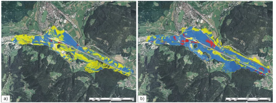
By increasing the rainfall intensities for the design events describing the basic assumptions for the delimitation of the hazard zone maps by 20%, the parameters needed for haz-ard evaluation changed as shown in Table 2. Figure 11 show the spatial changes of the inundation processes. The mod-elling results (flow depth and flow velocity) were classified following the guidelines for hazard zone mapping of the Au-tonomous Province of Bolzano – South Tyrol (Autonome Provinz Bozen – S¨udtirol, 2006) and Heinimann et al. (1998). Figure 12 shows the impacts of climate changes to the de-limitation of the compiled hazard zone maps (synthesis of all design events) by considering flow depth and flow velocity without further on-site investigations.
The study confirmed the results of prior analyses that the discharge capacity of the Rio Ridanna/Mareiter Bach in the Vipiteno/Sterzing basin is lower than the discharge of a de-sign event with a return period of 30 years. Either con-sidering the effects of climate changes to the hazard situa-tion or not, this fact leads to the endangerment of parts of the Vipiteno/Sterzing basin also during relatively frequent events. The historical analyses of flooding events in the Vip-iteno/Sterzing basin confirmed this fact (Zischg, 2005).
Fig. 12. Results of inundation modelling reclassified following the guidelines for hazard zone mapping (Autonome Provinz Bozen – S¨udtirol 2006; in red hazard zones, the construction of new buildings is restricted; in blue hazard zones, the construction of new buildings is regulated; in yellow hazard zones prevail hazards with low intensities). (a) Flood hazard map representing scenario 2000. (b) Flood hazard map representing scenario +20%.
0 1000000 2000000 3000000 4000000
HQ30 HQ100 HQ200
reoccurrence interval [years]
e
x
p
e
c
te
d
d
a
m
a
g
e
s
[
€
]
scenario 2000 scenario +20%
Fig. 13. Changes in expected damages due to flood events in the Vipiteno/Sterzing Basin for the scenario representing the present climate conditions and for the scenario representing possible future climate conditions.
flood hazards with a low intensity (yellow hazard zones) in future may be exposed to blue hazard zones. This is valid especially for the industrial buildings constructed during the last decade in the free spaces in the neighbourhood of the rivers, avoided for settlement in the decades before. The po-tential shifts from blue hazard zones to red hazard zones do not show significant consequences for buildings. The related risks increased for each scenario (Table 4 and Fig. 13). The expected damages of a flood event with a return period of 30 years (scenario +20%) increased up to 1700% (in com-parison to the scenario 2000). The expected damages of a flood event with a return period of 100 years increased up to 207% and up to 117% for an event with a return period of 200 years.
3.3 Potential impacts of climate changes to the delimita-tion of debris flow hazard zones, case study Rio Cen-gles/Tschenglser Bach
Table 4. Number of buildings endangered by flood processes of the Rio Ridanna/Mareiter Bach and expected damages per design events.
reoccurrence interval number of exposed buildings and related damages
scenario 2000 scenario +20%
habitation production damages [ C] habitation production damages [ C]
30 1 1 125 000 8 22 2 120 000
100 7 16 1 595 000 13 34 3 305 000
200 12 30 2 940 000 16 34 3 440 000
Table 5. Calculated rainfall and runoff values and bed load transport in the Rio Cengles/Tschenglser Bach torrent for relevant return periods and different climate conditions (IPP, 2007).
return period of a rainfall event, duration 60 min Ntot(precipitation) [mm] Qmax(discharge) at confluence [m
3/s] VB (volume of transported material) [m3]
scenario 2000 scenario +20% scenario 2000 scenario +20% scenario 2000 scenario +20%
30 years 55.6 66.7 31.5 44.4 59 000 80 000
100 years 74.2 89.0 47.3 70.4 73 000 110 000
300 years 81.2 97.5 63.5 86.5 83 000 119 000
4 Conclusions
The results of the approach for assessing and classifying the sensitivity of mountain torrent and torrential river catchments against the assumed climate changes showed where the fu-ture scenarios of natural hazards are expected to occur more likely. The analyses pointed out that the impacts of climate changes to the hazard situation of torrential and river sys-tems have a high spatial variability. The identification and localization of the torrent catchments, where unfavourable changes in the hazard situation occur could eliminate spec-ulative and unnecessary measures against the impacts of cli-mate changes like a general enlargement of hazard zones or a general over dimensioning of protection structures for the whole territory (e.g. as suggested by Hennegriff et al., 2006). Thus, the procedure could support the discussion about fu-ture strategies for adaptation to alternated climate conditions by providing the trends for the development of the hazard situation in a higher spatial resolution.
At the moment, the procedure for the identification and localization of torrent catchments does not consider quan-titatively future climate scenarios (e.g. global and regional climate models). This weakness in fact could be eliminated in future, but the qualitative approach allows the transfer of the approach to other areas. The dataset about the classified torrent and torrential river catchments and their sensitivity to climate changes provides the basis for the identification and localization of settlement areas, where increases in the future risk potential have to be expected.
As an example for the use of the dataset, the hazard in-dex map for debris flow processes (geo7, 2006; Zimmermann et al., 1997) was overlaid with the sensitive catchments and the settlement areas. The intersection of these two databases
leads to the identification and localisation of potential de-bris flow processes starting in catchments that are sensitive to changes due to permafrost degradation. The settlement ar-eas potentially affected by these debris flow processes were pointed out. The potential debris flow processes starting in catchments that are sensitive to permafrost degradation are endangering only insignificant parts of the settlements in the Autonomous Province of Bolzano. Thus, only these settle-ment areas are sensitive to this specific impact of climate change. But, the environmental changes in the starting areas of the debris flows endangering these sensitive areas must be observed and monitored.
The procedure for the identification and localisation of alpine torrent and torrential river catchments that are sensi-tive to climate changes provide an information basis for the identification of these cases, where the risk potential tends to increase. Because the impacts of climate changes to natu-ral hazards show remarkably regional differences, the knowl-edge about where the expected changes in the natural haz-ard situation have consequences to the risk situation is cru-cial for the consideration of the impacts of climate change in land use planning and risk management. The presented procedure provides a further information basis for decision-making in land use planning and natural hazard and risk man-agement with a long-term planning horizon. Furthermore, it provides a methodological framework for further refinement and enhancement of the consideration of the effects of cli-mate changes in natural hazards and risk management.
Fig. 15. Variations in flow depth and extent of a design event with a return period of 30 years (actual climate conditions) using different input parameters for the critical shear stress. (a) Flow depths for a design event with a return period of 30 years (scenario 2000). Critical shear stress parameter of 200 Pa. (b) Flow depths for a design event with a return period of 30 years (scenario 2000). Critical shear stress parameter of 400 Pa. (c) Flow depths for a design event with a return period of 30 years (scenario 2000). Critical shear stress parameter of 800 Pa.
remarkable impacts on the natural hazard situation (pro-cess intensities). The calculated increase of discharge due to the assumed increase in rainfall intensity showed a sig-nificant accentuation of the already existing weak points in the protection structures and the resulting hazard situation. The modelling results showed a remarkably increase in the flooded areas and an increase in flow depths. The hazard zones changed one “level” of hazard classification. Gener-ally, the “yellow” zones delineated on the basis of the ac-tual climate conditions tended to become “blue” zone. This could lead to significant restrictions for land use. The study demonstrated that already known weak points in risk reduc-tion systems as protecreduc-tion structures in future will become more important in risk management activities. This means that the stress-strain behaviour of these weak points in cases of discharges exceeding the channel capacity must be
stud-ied. The knowledge about the behaviour of protection struc-tures in loading case could provide a decision base for the elaboration of and the training of crisis management plans.
parameter “precipitation intensity” lay within the uncertainty of the methods used today for the delimitation of the hazard zones. Thus, the consideration of the uncertainties laying in the methods used for the elaboration of hazard zone maps would provide a useful instrument for the consideration of potential future climate conditions in sensitive catchments.
The case study of the Rio Cengles/Tschenglser Bach tor-rent confirmed the hypothesis that the bed load transport ca-pacity of torrents eroding older deposits increases with a po-tential increase in rainfall intensity. Due to the unlimited predisposition of mobilizeable material for debris flows, the process intensity of these torrents increases with the increase of bed load transport capacity because of higher discharges. The changes in process intensity in the deposition area of the debris flow are remarkable, but are lying within the un-certainties due to mostly poorly known process characteris-tics and models. The ranges of the modelling results due to changes in the input parameters of rheology and critical shear stresses of the debris flow simulation model exceed the ranges of the modelling results due to changes in the input parameter for rainfall intensity (Fig. 15).
The case study showed that possible effects of climate changes are not relevant for torrents that have been system-ized with remarkably efforts and where the runout and de-position areas of the torrential processes have been kept free from settlements and infrastructures. Nevertheless, the anal-yses showed that an assumed increase of rainfall intensity lead to a nonlinear increase of the process intensities. Espe-cially the volume transported by debris flows due to the in-crease in discharge and transport capacity inin-creased remark-ably when considering possible future climate conditions.
This lead to the conclusion that the sediment management in alpine torrents will meet future challenges. In future, the costs for maintenance of existing protection structures will increase due to higher deposition volumes and a higher fquency of removal of debris flow deposits from sediment re-tention basins. Thus, cost-benefit analyses made within the planning of new protection structures must consider the fu-ture higher operating expenses.
The study showed that an increase in the intensity and fre-quency of flood and debris flow hazards has to be expected as a consequence of climate changes in sensitive catchments. But, the effects of these changes in the hazard situation to the risk situation depend also on other factors in the risk equa-tion. The future changes in the extent of the damage po-tential and the vulnerability of endangered objects to natural hazard processes would also influence the future risk poten-tial. Thus, the consideration of impacts of climate changes in natural hazard and risk management must be made using a holistic approach combining all the available instruments and possibilities from risk prevention to land use planning and crisis management activities.
Appendix A
Table A1. Types of Alpine torrent catchments.
catchment type
ID decision tree
Description
WB01 082 Higher located mountain torrent catchments with minor bed load source areas, mainly recent deposits. WB02 146 Higher located mountain torrent catchments with minor bed load source areas, mainly recent deposits.
Important areas affected by permafrost degradation or glacier retreat.
WB03 098 Higher located mountain torrent catchments with major bed load source areas, mainly recent deposits. WB04 162 Higher located mountain torrent catchments with major bed load source areas, mainly recent deposits.
Important areas affected by permafrost degradation or glacier retreat.
WB05 084 Higher located mountain torrent catchments with minor bed load source areas, manly older deposits. WB06 148 Higher located mountain torrent catchments with minor bed load source areas, manly older deposits.
Important areas affected by permafrost degradation or glacier retreat.
WB07 100 Higher located mountain torrent catchments with major bed load source areas, manly older deposits. WB08 164 Higher located mountain torrent catchments with major bed load source areas, manly older deposits.
Important areas affected by permafrost degradation or glacier retreat.
WB09 088 Higher located mountain torrent catchments with minor bed load source areas and active landslides. WB10 152 Higher located mountain torrent catchments with minor bed load source areas and active landslides.
Important areas affected by permafrost degradation or glacier retreat.
WB11 104 Higher located mountain torrent catchments with major bed load source areas and active landslides. WB12 168 Higher located mountain torrent catchments with major bed load source areas and active landslides.
Important areas affected by permafrost degradation or glacier retreat.
WB13 083 Lower located mountain torrent catchments with minor bed load source areas, mainly recent deposits. WB14 147 Lower located mountain torrent catchments with minor bed load source areas, mainly recent deposits.
Important areas affected by permafrost degradation or glacier retreat. Not existing!
WB15 099 Lower located mountain torrent catchments with major bed load source areas, mainly recent deposits. WB16 163 Lower located mountain torrent catchments with major bed load source areas, mainly recent deposits.
Important areas affected by permafrost degradation or glacier retreat. Not existing!
WB17 085 Lower located mountain torrent catchments with minor bed load source areas, manly older deposits. WB18 149 Lower located mountain torrent catchments with minor bed load source areas, manly older deposits.
Important areas affected by permafrost degradation or glacier retreat. Not existing!
WB19 101 Lower located mountain torrent catchments with major bed load source areas, manly older deposits. WB20 165 Lower located mountain torrent catchments with major bed load source areas, manly older deposits.
Important areas affected by permafrost degradation or glacier retreat. Not existing!
WB21 089 Lower located mountain torrent catchments with minor bed load source areas and active landslides. WB22 153 Lower located mountain torrent catchments with minor bed load source areas and active landslides.
Important areas affected by permafrost degradation or glacier retreat. Not existing!
WB23 105 Lower located mountain torrent catchments with major bed load source areas and active landslides. WB24 169 Lower located mountain torrent catchments with major bed load source areas and active landslides.
Table A2. Types of torrential river catchments.
catchment type
ID decision tree
Description
WF01 082 Higher located torrential river catchments with minor bed load source areas, mainly recent deposits. Limited susceptibility to surface runoff.
WF02 146 Higher located torrential river catchments with minor bed load source areas, mainly recent deposits. Increased susceptibility to surface runoff.
WF03 098 Higher located torrential river catchments with major bed load source areas, mainly recent deposits. Limited susceptibility to surface runoff
WF04 162 Higher located torrential river catchments with major bed load source areas, mainly recent deposits. Increased susceptibility to surface runoff.
WF05 084 Higher located torrential river catchments with minor bed load source areas, mainly older deposits. Limited susceptibility to surface runoff
WF06 148 Higher located torrential river catchments with minor bed load source areas, mainly older deposits. Increased susceptibility to surface runoff.
WF07 100 Higher located torrential river catchments with major bed load source areas, mainly older deposits. Limited susceptibility to surface runoff
WF08 164 Higher located torrential river catchments with major bed load source areas, mainly older deposits. Increased susceptibility to surface runoff.
WF09 088 Higher located torrential river catchments with minor bed load source areas and active landslides. Limited susceptibility to surface runoff
WF10 152 Higher located torrential river catchments with minor bed load source areas and active landslides. Increased susceptibility to surface runoff.
WF11 104 Higher located torrential river catchments with major bed load source areas and active landslides. Limited susceptibility to surface runoff
WF12 168 Higher located torrential river catchments with major bed load source areas and active landslides. Increased susceptibility to surface runoff.
WF13 083 Lower located torrential river catchments with minor bed load source areas, mainly recent deposits. Limited susceptibility to surface runoff.
WF14 147 Lower located torrential river catchments with minor bed load source areas, mainly recent deposits. Increased susceptibility to surface runoff.
WF15 099 Lower located torrential river catchments with major bed load source areas, mainly recent deposits. Limited susceptibility to surface runoff
WF16 163 Lower located torrential river catchments with major bed load source areas, mainly recent deposits. Increased susceptibility to surface runoff.
WF17 085 Lower located torrential river catchments with minor bed load source areas, mainly older deposits. Limited susceptibility to surface runoff
WF18 149 Lower located torrential river catchments with minor bed load source areas, mainly older deposits. Increased susceptibility to surface runoff.
WF19 101 Lower located torrential river catchments with major bed load source areas, mainly older deposits. Limited susceptibility to surface runoff
WF20 165 Lower located torrential river catchments with major bed load source areas, mainly older deposits. Increased susceptibility to surface runoff.
WF21 089 Lower located torrential river catchments with minor bed load source areas and active landslides. Limited susceptibility to surface runoff
WF22 153 Lower located torrential river catchments with minor bed load source areas and active landslides. Increased susceptibility to surface runoff.
WF23 105 Lower located torrential river catchments with major bed load source areas and active landslides. Limited susceptibility to surface runoff
Table A3. Types of river catchments.
catchment type
ID decision tree
Description
FL01 Higher located alpine river catchments. Limited susceptibility to surface runoff.
FL02 Higher located alpine river catchments. Increased susceptibility to surface runoff.
FL04 Lower located alpine river catchments. Limited susceptibility to surface runoff.
FL02 Lower located alpine river catchments. Increased susceptibility to surface runoff.
Acknowledgements. The project was co-financed by the European Union within the Interreg IIIB Alpine Space project “ClimChAlp – Climate Change, Impacts and Adaptation strategies for the Alps”. The authors thank to C. Scherer and B. Mazzorana for the sim-ulation of the flood processes, A. Waldner and W. Gostner for modelling the debris flow processes and M. Eschgf¨aller for the lit-erature review. Furthermore, the authors thank to V. Jomelli and another anonymous referee for their constructive remarks.
Edited by: F. Castelli
Reviewed by: V. Jomelli and another anonymous referee
References
Autonome Provinz Bozen – S¨udtirol: Richtlinien f¨ur die Erstellung von Gefahrenzonenpl¨anen und zur Klassifizierung des spezifis-chen Risikos, Bozen, 2006.
Bader, S. and Kunz, P.: Klimarisiken – Herausforderung f¨ur die Schweiz, Zurich, 1998.
Bardossy, A. and Pakosch, S.: Wahrscheinlichkeiten extremer Hochwasser unter sich ¨andernden Klimaverh¨altnissen, Wasser-wirtschaft, 97, 58–64, 2005.
Beven, K. J., Lamb, R., Quinn, P., Romanowicz, R., and Freer, J.: TOPMODEL. In: Computer Models of Watershed Hydrology, edited by: Singh, V. P., Water Resources Publications, 1995. Brunetti, M., Maugeri, M., and Nanni, T.: Changes in total
precip-itation, rainy days and extreme events in northeastern Italy, Pure and Applied Geophysics, 21, 861–871, 2001.
Caspary, H. J.: Recent winter floods in Germany caused by changes in the atmosperic circulation across Europe, Physics and Chem-istry of the Earth, 20, 459–462, 1996.
Caspary, H. J.: Zunahme “kritischer” Wetterlagen als Ursache f¨ur die Entstehung extremer Hochwasser in S¨udwestdeutschland, in: Klimaver¨anderung und Konsequenzen f¨ur die Wasserwirtschaft – Fachvortr¨age beim KLIWA-Symposium am 3. und 4.5.2004 in W¨urzburg, 135–151, 2004.
Caspary, H. J. and Bardossy, A.: Markieren die Winterhochwasser 1990 und 1993 das Ende der Stationarit¨at in der Hochwasserhy-drologie infolge Klima¨anderungen? Wasser & Boden, 47, 18–24, 1995.
Christensen, J. H. and Christensen, O. B.: Climate modelling: Se-vere summertime flooding in Europe, Nature, 421, 805–806, 2003.
Frei, C., Sch¨oll, R., Fukutome, S., Schmidli, J., and Vidale, P. L.: Future change of precipitation extremes in Europe: Intercompar-ison of scenarios from regional climate models, J. Geophys. Res., 111, D06105, doi:10.1029/2005JD005965, 2006.
Fuchs, S., Heiss, K., and H¨ubl, J.: Towards an empirical vulnerabil-ity function for use in debris flow risk assessment. Nat. Hazards Earth Syst. Sci., 7, 495–506, 2007,
http://www.nat-hazards-earth-syst-sci.net/7/495/2007/.
geo7: Gefahrenhinweiskarte Murgang und ¨Ubersarung. Technis-cher Bericht. Unpublished project report within the Interreg IIIA Italy-Switzerland project “Entwicklung und Anwendung eines Systems zur ¨uberregionalen Erkennung und Bewertung hydro-geologischer Risiken”, Bozen, 27 pp., 2006.
geo7: Gefahrenhinweiskarte Murgang und ¨Ubersarung: Auswer-tung im Hinblick auf die Klima¨anderung. Erl¨auterungen zum Entscheidungsbaum, Unpublished report within the project In-terreg IIIB Alpine Space “ClimChAlp - Climate Change, Impacts and Adaptation Strategies in the Alpine Space”, Bozen, 34 pp., 2007.
Gius, S.: Die Gefahrenzonenplanung in S¨udtirol, Wildbach- und Lawinenverbau 152, 49–61, 2005.
Gostner, W.: Integrale Analyse eines murf¨ahigen Wildbaches an-hand einer Fallstudie. Unpublished M.S. thesis, ETH Lausanne, Lausanne, 203 pp., 2002.
Harris, C., Davies, M. C. R., and Etzelm¨uller, B.: The assessment of potential geotechnical hazards associated with mountain per-mafrost in a warming global climate. Perper-mafrost Periglac., 12, 145–156, 2001.
Heimann, D. and Sept, V.: Climate change estimates of summer temperature and precipitation in the Alpine region. Theor. Appl. Climatol., 66, 1–12, 2000.
Heinimann, H., Hollenstein, K., Kienholz, H., Krummenacher, B., and Mani, P.: Methoden zur Analyse und Bewertung von Naturgefahren. Umweltmaterialen Bundesamt f¨ur Umwelt, Wald und Landschaft, Bern, 249 pp., 1998.
Hennegriff, W., Kolokotronis, V., Weber, H., and Bartels, H.: Kli-mawandel und Hochwasser. Erkenntnisse und Anpassungsstrate-gien beim Hochwasserschutz. Wasser, Abfall, 53, 770–779, 2006.
IPP Ingenieure Patscheider and Partner GmbH: Untersuchungen zur Sensitivit¨at der Murganggefahr des Tschenglser Baches gegen¨uber m¨oglichen Klimaver¨anderungen. Unpublished report within the project Interreg IIIB Alpine Space “ClimChAlp - Cli-mate Change, Impacts and Adaptation Strategies in the Alpine Space”, Bozen, 2007.
Geomor-phic Variations of Debris Flows and Recent Climatic Change in the French Alps, Climatic Change, 64(1), 77–102, 2004. Jomelli, V., Brunstein, D., Grancher, D., and Pech, P.: Is the
re-sponse of hill slope debris flows to recent climate change univo-cal? A case study in the Massif des Ecrins (French Alps), Cli-matic Change, 85(1), 119–137, 2007.
Katzenberger, B.: Bisherige Erkenntnisse aus KLIWA - Hand-lungsempfehlungen. In: KLIWA, (ed.): Klimaver¨anderung und Konsequenzen f¨ur die Wasserwirtschaft – Fachvortr¨age beim KLIWA-Symposium am 3 und 4 Mai 2004 in W¨urzburg, 197– 204, 2004.
Kienholz, H., Krummenacher, B., Kipfer, A., and Perret, S.: Aspects of integral risk management in practice - Consid-erations with respect to mountain hazards in Switzerlands,
¨
Osterreichische Wasser- und Abfallwirtschaft, 3–4, 43–50, 2004. KOHS – Kommission Hochwasserschutz im Schweizerischen Wasserwirtschaftsverband: Auswirkungen der Klima¨anderung auf den Hochwasserschutz in der Schweiz. Ein Standortpapier der Kommission Hochwasserschutz im Schweizerischen Wasser-wirtschaftsverband (KOHS), Wasser, Energie, Luft, 99(1), 55– 59, 2007.
O’Brien, J. S. and Julien, P. Y.: FLO-2D, Users Manual, Version 2001.06, 2001.
OcCC: Klima¨anderung und die Schweiz 2050, Erwartete
Auswirkungen auf Umwelt, Gesellschaft und Wirtschaft, Bern, 172 pp., 2007.
Rebetez, M., Lugon, R., and Baeriswyl, P.-A.: Climatic Change and debris Flows in High Mountain Regions: The Case Study of the Ritigraben Torrent (Swiss Alps), Clim. Change, 36, 371–389, 1997.
Regional Office of Carinthia, Department of Water Economy: Rain-fall/Runoff Model for small catchment areas in the Lavant Valley for determination of potential future effects through assessment of regional climate change scenario. Interreg IIB Alpine Space project ClimChAlp – Climate Change, Impacts and Adaptation Strategies in the Alpine Space, Project report of WP 5 – Climate Change and Resulting Natural Hazards, Klagenfurt, 2008. Sch¨adler, B., Frei, C., Grebner, D., and Willi, H. P.: Grundlagen
zum Klima, Wasser-Energie-Luft, 1, 58–59, 2007.
Stoll, C.: Sch¨atzung des Schadenpotenzials bei Hochwasser-ereignissen durch die Ahr bei Uttenheim und St. georgen und durch die Rienz im Bereich Bruneck bis St. Lorenzen. Unpub-lished report for the Interreg IIIB project ”River Basin Agenda”, Bruneck, 80 pp., 2004.
Scherer, C. and Mazzorana, B.: Schutzwasserbau f¨ur den Oberen Eisack, Bericht zur Hydraulik. Unpublished report within the project Interreg IIIB Alpine Space “River Basin Agenda”, Bozen, 66 pp., 2005a.
Scherer, C. and Mazzorana, B.: Schutzwasserbau f¨ur den Oberen Eisack. Bericht zur Hydrologie. Unpublished report within the project Interreg IIIB Alpine Space “River Basin Agenda”, Bozen, 117 pp., 2005b.
Scherer, C. and Mazzorana, B.: Gefahrenszenarien im Einzugsge-biet des Mareiter Baches. Unpublished report within the project Interreg IIIB Alpine Space “ClimChAlp - Climate Change, Im-pacts and Adaptation Strategies in the Alpine Space”, Bozen, 129 pp., 2007.
St¨otter, J.: Ver¨anderungen der Kryosph¨are in Vergangenheit und Zukunft sowie Folgeerscheinungen. Habilitation thesis, Univer-sity of Munich, Munich, 264 pp., 1994.
St¨otter, J. and Zischg, A.: Alpines Risikomanagement – the-oretische Ans¨atze, erste Umsetzungen, in: Naturrisiken und Sozialkatastrophen, edited by: Felgentreff, C. and Glade, T., Berlin, Heidelberg, 297–310, 2007.
United Nations: Living with risk. United Nations, Geneva, 2004. Villi, V. and Bacchi, B.: Valutazione delle piene nel Triveneto,
CNR-GNDCI Consiglio nazionale delle ricerche – Gruppo nazionale per la difesa dalle catastrofi idrogeologiche, Padova, Brescia, 2001.
Zimmermann, M., Mani, P., and Gamma, P.: Murganggefahr und Klima¨anderung – ein GIS-basierter Ansatz. vdf, Zurich, 161 pp. 1997.