Android App Based Vehicle Tracking Using GPS
And GSM
Jessica Saini, Mayank Agarwal, Akriti Gupta, Dr. Manjula R
Abstract: Global Positioning System (GPS) is used in numerous applications in today‘s world. A real time vehicle tracking system using the GPS technology is proposed in this paper. The project Android App based Vehicle Tracking Using GSM AND GPRS mainly focuses in tracking the location of the vehicle on which the device has been installed. It will then send the data in the form of latitude and longitude coordinates through SMS on the user‘s mobile where the coordinates will be plotted in the Android app automatically. Initially, the GPS installed in the device takes input from the satellite and stores it in the microcontroller‘s buffer. In order to track the vehicle, the mobile user has to call on the SIM number that is registered in the GSM module of the device. Once the call is received, the device authenticates the calling number. If authenticated, the location of the vehicle is sent to the registered mobile number in the form of SMS. After sending the message, the GSM is deactivated and the GPS is activated again. The coordinates of the location received in the SMS can be viewed on the android app. The hardware part described in the paper comprises of GPRS, GSM module, LCD to view the coordinates, ATMega Microcontroller MAX 232, Arduino, RS232 and relay.
Index Terms: Vehicle Tracking, GSM, Android App, Sensors, Google Maps, Arduino, SIM, GPS
————————————————————
1.
INTRODUCTIONThe GPS GSM based system combines GPS and GSM technologies. It is widely used in many applications and millions of users are benefitted by it everyday. The product is mainly intended to increase the security and safety amongst the transportation system. This vehicle-tracking device can be installed in any vehicle to prevent thefts or to monitor the route of the vehicle. Whenever a vehicle is stolen or is lost, the device will send the coordinates of latitudes and longitudes that will help to locate the vehicle on user‘s mobile. The tracking system covers most of the highways, major cities, towns and most of the accessible villages and works efficiently in areas with better mobile connectivity. This paper explains an embedded system, which is used to know the location of the vehicle using the popular and readily available technologies like the Global Positioning System (GPS) and Global System for mobile communication (GSM). The main feature of our design is that it proposed to use a development board, which will have GPS and GSM module not as a separated module but closely linked with a microcontroller as in Tanotis Gboard Pro GSM/GPRS SIM900 Development Board ATmega328 Microprocessor. The advantage of using that development board is that it will reduce the size of whole system and it will reduce the power loss in terms of heat through external wirings used for the connection of GPS and GSM module with the microcontroller. Along with that, it will also increase the durability of the entire system. The ATMega328 microcontroller will provide the interfacing to various hardware peripherals. To know the location of vehicle, the mobile user has to click on the Track location button in the android app. The message will be automatically sent to the SIM present in the GSM module present in the device. The system will respond by sending the coordinates (sensed by the GPS module) of the vehicle on the registered mobile user and these coordinates will be plotted on the map.
2.
LITERATURE REVIEWIn [1], GPS and GSM technologies have been used in a way so that they can track the location of the stolen vehicle. In this system the car stays in an active mode while the owner is using it otherwise it is in its active mode. Then in the active mode if there is any disturbance, it is sensed by the IR sensor. It sends the location of the car to the owner. When the owner replies then the engine motor speed decreses and gradually
54 location of vehicle in term of longitudes and latitudes. Then
the GSM sends a message to the owner and as soon it is received it is plotted on the Google Earth. In order to identify the direction of the moving vehicle, the device is installed with a compass sensor. Also, in order to know the state of the vehicle whether it is moving or not, an accelerometer sensor is used. In [18], S. Sahitya, N. Swetha designed a tracking system, which could be used in real life scenarios. The primary components used in designing were GSM and GPS. Google Maps is used to plot and view the location of the coordinates that have been sent on a desktop or mobile device by plotting the coordinates. We have eliminated the job of manually plotting the coordinates on the map. This job is automatically done by the app itself. In [19], the existing system of using Google Maps, automatic transit direction has been replaced with RFID –radio frequency identification for safety of private and public automobiles. It is a wireless identifiaction system which can monitor any object, human or animals. RFID improves the overall performace and cost. It also speaks about the use of GSM in telling us the exact location. In [21], the system that is proposed by the authors is a real-time implementation of the website that is based on the GoogleMap. The location sending procedure involves connecting cellular antenna by the GPRS module. On receiving the location coordinates via GPS module, the position is sent to the database servers. The vehicle location is then displayed on the website after the data is received from the database servers. In [22], an experimental evaluation of GSM and GPS module has been given. It clearly gives us the details of hardware and software components of the system.The hardware design consists of the mobile unit and the control station. The software design tells the way in which GPS and mobile and GSM interacts with each other and different condition available. The difference in using ordinary and differential GPS.
Comparison of the existing GPS devices installed in vehicles with the android app based vehicle-tracking system
The existing GPS devices installed in the vehicles allows you to know the location of the destination. The GPS network comprises of 27 global positional satellites. In each of the 6 orbital planes, there are four satellites, which ensure that they cover the entire world. Each satellite transmits a radio signal, which is processed by the receiver in the car. A minimum of three or four satellites is required to know the position of the destination entered. This method is known as trilateration. However the existing GPS navigation system installed in the cars does not provide any provision to the owner in case he/she wants to know the location of the vehicle. This is where Android app based vehicle tracking system comes into the picture. This system is designed for all the cars and the users with Android phones. The Android is the most widely used mobile OS. Its availability and popularity amongst the users is the reason that we have designed the app for Android users to target and benefit more audience. The interface of the app is easy to understand. The user just has to press one button in order to know the location of the vehicle. On pressing the button, an SMS will be sent to the device installed in the vehicle. This device will first authenticate the number from which the SMS is sent. If found valid, it will send the coordinates of the location to the owner‘s mobile. Once the SMS is received, the coordinates of the location will be
immediately plotted by the app itself and the location of the vehicle will be known. This device will help the owner to always keep an eye on its vehicle.
3.
M
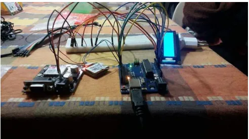
ETHODOLOGY3.1 Block Diagram
Figure 1: Block diagram
3.2 Diagram Description
The microcontroller 8052 is used for interfacing the hardware peripherals. There is serial interfacing between the 8052 microcontroller and the GSM Modem and GPS receiver. The working of the system involves taking the input from the GPS. This input is then sent to the RS232. It is then sent to MAX232 where the data is formatted so that it could be sent to the receiver pin (Rx) of the microcontroller. After this, the data is stored in the microcontroller buffer and then sent to the MAX232 via the TX (Transmitter pin). The data is sent into GSM via the RS-232 protocol by MAX232. On demand that is by pressing the ‗Track location‘ button in the android app, it will send the location of the device to the registered mobile user. The location of the vehicle will be shown to the user on the designed android app. The code for the device is written and tested in Arduino IDE. The Arduino IDE is a cross-platform application where the code is written, debugged and tested. The android app is designed in android studio.
4
FUNCTIONALITIES AND OVERVIEW OF THE SYSTEM4.1 GPS Technology:
GPS (Global Positioning System) works in all the weather conditions be it storm be it flood, covering the entire world 24*7 through out the year absolutely for free. This satellite based navigation system has GPS satellites, which orbit the Earth two times in a day. Each and every satellite sends a unique signal to the GPS receivers. The GPS receivers then decode the signals and then calculate the exact location of the user. The receiver basically takes the time taken by it to receive signals as the source of calculating position.
4.2 GSM Technology
The working of Global System for Mobile Communication (GSM) is just like a mobile phone. It is basically a modem on which a SIM is installed and it operates over a subscription. GSM networks mainly comprises of three major systems: The Switching System (SS),
The Base system (BS) Mobile Station (MS).
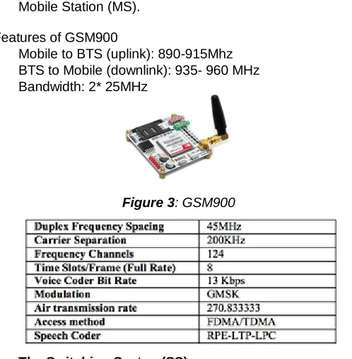
Features of GSM900
Mobile to BTS (uplink): 890-915Mhz BTS to Mobile (downlink): 935- 960 MHz Bandwidth: 2* 25MHz
Figure 3: GSM900
1. The Switching System(SS)
SS consists of five databases that perform distinct functions. Call processing and subscriber related functions are its prime tasks. It has five databases which are as follows
Home Location Register(HLR), Visitor Location Register(VLR), Authentication Centre(AUC), Mobile Switching Centre (MSC) Equipment Identity Register (EIR).
2. The Base Station System (BSS)
BSS has further two divisions viz. BTS and BSC. The base transceiver station (BTS) consists of radio transceivers. The number of transceiver stations increases with the size of the area. The main job of base station controller is to manage the radio resources for one or more transceiver stations. The connection between the mobile station and the mobile services center is facilitated by it.
Figure 4: Working of the GSM modem along with Arduino Uno
3. Mobile Station
The mobile station consists of mobile equipment and a smart card, which is commonly known as SIM (Subscriber‘s Identity Module). It permits clients to have entry to subscribed administrations regardless of a particular terminal. Keeping in mind the end goal to make and get the calls, the SIM is embedded to the GSM terminal. In order to identify the mobile equipment it uses International Mobile Equipment Number (IMEI). The SIM card is fitted with International Mobile Subscriber Identity that is utilized as a part of the recognizable proof of the supporter of the framework and identifying the subscriber. The IMEI and IMSI are autonomous.
Elements of GSM1800
Portable gear to BTS (uplink): 1710-1785 MHz BTS to Portable gear (Downlink): 1805-1880 MHz Bandwidth: 2*75 MHz
4.3 Microcontroller
ATMega328 is the ATMEL Microcontroller on which Arduino UNO is based. It is a single chip microcontroller created by AMTEL in mega AVR family. AVR is a family of microcontrollers developed by Atmel. It facilitates the interfacing of the GPS and the GSM module. Its use reduces the cost of the system, and its small and compact design makes the device handy.
4.4 MAX232
56
4.5 RS232 Protocol
Recommended Standard Number 232 (RS-232) an asynchronous protocol for the serial data exchange. It defines common ground for voltage and signal level between Data Terminal Equipment (DTE) and Data Communications Equipment (DCE). Your PC is a DTE gadget, while most different gadgets are normally DCE gadgets. The attributes, timing, meaning of signals, physical size and pin out of connectors are defined by this standard.
4.6 Arduino IDE
The code to be uploaded in the Arduino is written, tested and debugged in Arduino IDE. It is an IDE (Integrated Development Environment) for the Processing programming language and the Wiring project.
4.7 Android App
The Android app included in the project has been written, tested and debugged in the Android Studio. The Figure 5 shows the app interface when the app is opened on the Android user. Once the user presses the ‗Request Location button‘, an SMS to the device is sent to fetch the coordinates of the vehicle‘s location. This location is then plotted in the app.
Figure 5:Android app interface of the receiver section
5
EXPERIMENTAL
RESULTS
The device was tested in Vellore Institute of Technology. It was found that the location of the vehicle was predicted effectively in most of the cases. However, the location shown in the app can have an error of approximately 10 meters due to limitation in the hardware.
Figure 6:The location of the vehicle
6
U
SABILITYIt is very user-friendly. In order to know the vehicle‘s location, all a user has to do is to type a text message on the mobile and send it to the SIM number installed in the device. It is secure as only the location of the device will be sent to the registered mobile user.
7
APPLICATIONSThe vehicle tracking system can be used in a number of areas The main users of the product are the transportation companies. Companies and start-ups that provide cabs can install the device in their vehicles to ensure the safety of passengers and vehicle.
Schools could also install the device in school vans can keep a constant check on the route of the vans for the sake of students‘ safety.
It could be used in Bus stands by the managers to effectively predict and display the timing of the arriving buses for the waiting passengers.
8
FUTURE SCOPEthe product could also be used to turn off the vehicle‘s engine in case if the vehicle is stolen. It is possible to make the device wearable by reducing the size of the hardware so that not only for finding the location of vehicle but the device could also be used to find the location of a person.
9. CONCLUSION
In today‘s world, the security of the vehicles is at stake. The incidents of theft are common. This compels the consumer to install a tracking device, which will help them to know the location of their lost or stolen vehicle. The vehicle-tracking device provide the user to know his/her vehicle‘s location in real time. The product designed is user-friendly anyone with a little knowledge of smartphone can use the system. It is easy to install the system in the vehicle and it require low maintenance. The coordinates received show the correct location on the google map using the android app. Also, the size of the device is compact since the GSM and GPS modules are not present as separate module.
10.
A
CKNOWLEDGMENTThe authors are grateful to Dr. Manjula R for her guidance in this project and Vellore Institute of Technology for providing us with an opportunity to write the paper.
11.
R
EFERENCES[1] R.Ramani, S. Valarmathy, Dr. N Suthanthira, S. Selavaraju, M.Thiruppathi, R.Thagam, ―Vehicle Tracking and Locking Based GSM and GPS‖, Issue Date: Sept 2013
[2] F. M Franczyk, and J.D. Vanstone, ―Vehicle Warning System‖, Patent number: 73639, Issue Date: 22 Apr 2008.
[3] William Stalling, ―Wireless Communication and Networks‖, 2nd edition, prentice hall of India, 2005
[4] Krishna Kant, ―Microprocessor and Microcontroller‖, Eastern Company Edition, New Delhi 2007
[5] Kunal Maurya, Mandeep Singh, Nellu Jain, ―Real Time Vehicle Tracking System using GSM and GPS technology- An Antitheft Tracking System‖, International Journal of Electronics and Computer Science Engineering, ISSN 2277-1956/VIN3-1103-1107
[6] Kai-Tai Song, Chih-Chieh Yang, of National Chiao Tung University, Taiwan, ―Front Vehicle Tracking Using Scene Analysis‖, Proceedings of the IEEE International Conference on Mechatronics & Automation 2005.
[7] R.S Gaonkar, ―Microprocessor Architecture Programming and Application‖, Wiley Eastern Limited, New Delhi
[8] Chen H., Chiang, Y. Chang, F.H. Wang, Toward Real-Time Precise Point Positioning: Differential GPS Based on IGS Ultra Rapid Product, SICE Annual Conference, The Grand Hitel, Taipei, Taiwan August 18-21, (2010)
[9] Vikram Kulkarni & Viswaprakash Babu, ―embedded smart car security system on face detection‘, special issue of IJCCT, ISSN (Online): 2231-0371, ISSN (Print):0975-7449,volume-3, issue-1
[10]
El-Medany,W.;Al-Omary,A.;Al-Hakim,R.;Al-Irhayim,S.;Nusaif,M.,"A Cost Effective Real-Time Tracking System Prototype Using Integrated GPS/GPRS Module," Wireless and Mobile Communications (ICWMC), 2010 6th International Conference on,vol.,no.,pp.521,525,20-25 Sept.2010
[11]Fleischer, P.B.; Nelson, A.Y.; Sowah, R.A.; Bremang, A., "Design and development of GPS/GSM based vehicle tracking and alert system for commercial inter-city buses," Adaptive Science & Technology (ICAST), 2012 IEEE 4th International Conference on , vol., no., pp.1,6, 25-27 Oct. 2012
[12]Le-Tien, T.; Vu Phung-The, "Routing and Tracking System for Mobile Vehicles in Large Area," Electronic Design, Test and Application, 2010. DELTA '10. Fifth IEEE International Symposium on , vol., no., pp.297,300, 13-15 Jan. 2010
[13]Abed khan M.E.(Student), , Ravi Mishra, ―GPS – GSM Based Tracking System‖ SSCET, CSVTU, Bhilai, India International Journal of Engineering Trends and Technology- vol.3,no.,pp,161-164, 2012
[14]El-Medany, W.M.; Alomary, A.; Al-Hakim, R.; Al-Irhayim, S.; Nousif, M., "Implementation of GPRS- Based Positioning System Using PIC Microcontroller," Computational Intelligence, Communication Systems and Networks (CICSyN), 2010 Second International Conference on , vol., no., pp.365,368, 28-30 July 2010
[15]Iman M. Almomani, Nour Y. Alkhalil, Enas M. Ahmad, Rania M. Jodeh ―Ubiquitous GPS Vehicle Tracking and Management System‖, IEEE Jordan Conference on Applied Electrical Engineering and Computing Technologies (AEECT) 2011
[16]Lita, I.; Cioc, I.B.; Visan, D.A., "A New Approach of Automobile Localization System Using GPS and GSM/GPRS Transmission," Electronics Technology, 2006. ISSE '06. 29th International Spring Seminar on , vol., no., pp.115,119, 10-14 May 2006
[17]Shu Wang, Jungwon Min and Byung K. Yi,"Location Based Services for Mobiles: Technologies and Standards", IEEE International Conference on Communication (ICC), Beijing, China, 2008.
[18]S. Sahitya, N. Swetha, ―Real Time Vehicle Tracking Using GPS and GSM‖, International Journal Of Research in Computer And Communication Technology, ISSN (O) 2278-5841
[19]Lita, I.; Cioc, I.B.; Visan, D.A., "A New Approach of Automobile Localization System Using GPS and GSM/GPRS Transmission," Electronics Technology, 2006. ISSE '06. 29th International Spring Seminar on , vol., no., pp.115,119, 10-14 May 2006
58 Standards", IEEE International Conference on
Communication (ICC), Beijing, China, 2008.
[21]S. Sahitya, N. Swetha, ―Real Time Vehicle Tracking Using GPS and GSM‖, International Journal Of Research in Computer And Communication Technology, ISSN (O) 2278-5841
[22]A Real-Time GPS Vehicle Tracking System Displayed on a Google-Map-Based Website, Prawat Chaiprapa, Supaporn Kiattisin and Adisorn Leelasantitham Computer and Multimedia Engineering, School of Engineering,University of the Thai Chamber of Commerce.
[23]Experimentally Evaluation of GPS/GSM Based System Design Asaad M. J. Al-Hindawi1 , Ibraheem Talib2 Department of Communication Engineering Sulaimani Technical College Sulaymaniyah, Iraq Department of Electrical & Communication Engineering University of Al-Nahrain University Baghdad, Iraq