* To whom all correspondence should be addressed.
Basin and Eco-regional Approach to Optimize
the use of Water and Land Resources
Oleg Petrovich Yermolaev1, Fedor Nikolaevich Lisetskii2, Olga Andreevna Marinina1 and Zhanna Arkadevna Buryak2
1Kazan (Volga Region) Federal University, Russia, 420008, Kazan, Kremlyovskaya Street, 18 2Belgorod State National Research University, Russia, 308015, Belgorod, Pobedy Street, 85
doi: http://dx.doi.org/10.13005/bbra/2185
(Received: 26 July 2015; accepted: 03 September 2015)
The paper presents the principles of justification of the boundaries and composition of ecoregions as hydrologically separate, integral natural and economic structures, within which a quantitative and qualitative assessment of the results of the geoplanning of integrated components of the territories of nature, population and economy on the basin principle can be most effectively carried out. The work included the integration of a number of approaches: basin-administrative, eco-regional and ecologically-oriented municipalities development through long-term systems of management or natural resources. The boundaries and composition of ecoregions were grounded, database for information support of the hierarchical classification of river basins from eco-regional positions was prepared. The efficiency of implementing the concept of basin organization of the territory was assessed, as well as its regulatory and legal support and practical implementation on the example of the territory of one of the subjects of the Russian Federation (Belgorod region), which will provide sustainable development of municipalities in modern conditions by harmonizing natural, economic, social and demographic processes on their territory at a basin-administrative system of management of natural resources.
Key words: eco-regional approach, river basins, basin-administrative approach, management of natural resources, geoplanning, zoning, water erosion, land monitoring.
Strengthening of human transformation of the landscape in a certain way largely focuses on the transformation of small river basins, which determines the high demand for objective zoning of catchments by levels of environmental stress on their territories. As a result of ecological and hydrological zoning, the borders of ecoregions outside the administrative borders can be allocated – integral formations, which are assessed by the extent of human influence and transformation of natural landscapes (Kochurov et al., 2002). In the author’s understanding (Kochurov et al., 2002), “ecoregion” as an object of study should be
The relevance of the assessment and forecasting of the state of the environment in the agriculturally developed regions is determined by increasing anthropogenic load on the basin geosystems, which contributes to the development of a number of negative processes (erosion and river bed evolution, changes in the river flow regime, lack of drinking water resources). This necessitates the study of basin geosystems response to anthropogenic impact, as well as on climate change, whose impact in different landscape zones is manifested in different ways.
Geoecological foundation of sustainable development of the region based on the basin management of natural resources involves the use of a systematic approach to the organization of soil and water conservation measures by considering basins and anthropogenic load within it as a single integrated system consisting of interconnected blocks (water and other natural objects, sources of anthropogenic load and so on), which are connected by causal relationships.
When drawing the borders of ecoregions, it is recommended (Kochurov et al., 2009) to take into account mainly natural borders. However, it raises the question of the distribution of powers in territory management, and to solve organizational and financial problems it is necessary to combine homogeneous natural and economic entities with territories. The solution is to use basin-administrative approach to the differentiation of the territories, in which the boundaries of the ecoregion will be combined with watersheds of the river basins, mostly located within the boundaries of one territory.
Administrative-basin structure of the territory can be presented both at the macro level – governmental (Korytny, 2006) and at the regional level. For example, for the territory of the Central Black Earth region of Russia (area of 168 thous. km2), 152 river basins were allocated, and their
morphology, structure and quality of the land fund were studied (Spesivy, 2013); for the Volga Federal District (area of 1,034 thous. km2), automated
allocation of the borders of basin geosystems was made (Ermolaev et al.., 2014). Earlier (Narozhnyaya, 2011; Kuzmenko et al., 2013), according to the radar scan data, the structure of the valley, gullies and ravines network was determined within the Belgorod region (area of 27 thous. km2), and 63
river basins were allocated with area from 67 to 1,517 km2 for rivers of the 3-7th order under the
Straler-Filosofov system.
Eco-regional approach to monitoring and managing the quality of soil, land and water resources in many essential respects complements the basin approach and can be realized in parallel with it. In a specific ecoregion, a ”background” quality of local runoff is formed (Zemtsov, 2011), including regional geochemical conditions and historically developing economic activities that define the features of non-point (geographically distributed) sources of contaminants. Features of the chemical composition of water bodies of the ecoregion will be determined by the concentration of priority pollutants in them, whose spectrum is due to the dominant economic sector in the catchment area: in the case of agricultural development, such components are potassium, nitrogen, phosphorus; in the case of reclamative development – sulfates and iron; in the case of industry development – chloride and sulfate ions. Ecoregions may vary by a particular characteristic range of indicators of water quality and therefore targets of water bodies to be set taking into account the ecological and economic situation in the catchment area. This integrated approach to regulation of water bodies is used in Europe and the United States (Bolstad and Swank, 1997; King
et al.., 2005; Tran et al.., 2010; etc.), and this principle was the basis of the Water Policy Directive of the European Union (Directive ..., 2000), which aims to prevent the deterioration of aquatic ecosystems and groundwater and their protection and recovery (Moss, 2008). The combination of basin and eco-regional approach allows to allocate homogeneous natural and economic conditions of the territory, which will be subject to management of natural resources and environmental monitoring as an integrative system of agro-ecological and hydrological monitoring.
METHODS
conditions. Reducing the environmental stress is only possible with a more differentiated approach to the analysis of the territory and the allocation of the ecoregions within the subjects of the country that directly carries out environmental activities. In this study, the territory of one of the subjects of the Russian Federation – Belgorod region was selected as the object of study, which belongs to the Central Russian ecoregion, characterized by environmental stress of the highest, VII rank, where areas with very sharp and acute environmental situations dominate.
In order to justify the borders of the ecoregion within the Belgorod region, where basin-administrative principles of management of natural resources can be naturally implemented, it was necessary to analyze the multi-ordinal basin structure of the territory and allocate internal, interregional and cross-border catchment areas in accordance with municipal boundaries. The basis for determining membership of a particular river basin to the ecoregion was its location in the hydrographic system and its association with territories. Most of the small rivers of the Belgorod region have the source and the mouth within it. Since the watershed of the 4th order was chosen as the lower operational and territorial unit in geoplanning (Lisetskii et al.., 2014b), the external configuration of the egoregion in the Belgorod region was determined in accordance with this hierarchical level of the basin organization. The basin areas of the 5-7th order were differentiated in more detail, which allowed to get 217 basin structures of the 4-7th order. For all the rivers and their basins in the GIS application ArcGIS 9.2, lengths and areas, both within the Belgorod region and in general, according to the registries of water in Russia and Ukraine, were analyzed. The analysis allowed to define configuration and composition of the ecoregion for the first time. Quantification of areas of arable land and forest plantations was carried out in GIS on the basis of vector digital maps (Buryak et al.., 2014). Information about the structure of the land was updated on the basis of high resolution satellite images. The Field Calculator tool in the attribute table of vector layer for each river basin allowed to calculate the river network density.
Calculation of the relief function (LS) was made using the R.P.C. Morgan formula (1979):
),
S
0.138
S
0.965
(1.38
100
L
LS
=
⋅
+
⋅
+
⋅
2where L – length of the slope, from the watershed, m; S – slope, %.
For the obtained grid of values for the relief function, mean values of the relief function LS were calculated by the method of zonal statistics, which in different contexts differ 6.5 times – from 0.7 to 4.6. The proportion of the area of the slopes of the southern exposure for each basin was calculated based on the grid of exposures distribution received from DEM, with sample values of azimuth in the range of 135 to 225°.
Using the Spatial Analyst module and extrapolation of isolines, the grid of distribution of the erosive rainfall index in the Belgorod region was obtained. The Zonal Statistics tool allowed to determine the weighted average value of this indicator for each basin. To generate information base of geoplanning of the agriculturally developed Belgorod ecoregion, the assessment of the agricultural landscapes by watersheds was made, among which the most environmentally fragile areas were identified.
In order to ensure a fair procedure of the typology of the river basins, the algorithm of tree clustering using the Ward’s method in squared Euclidean distance was used in this study. It allowed to structure the data array based on the convergence of the characteristics and to group the objects of observation into homogeneous clusters based on the level of aggregation, which allows to identify the most related components.
RESULTS AND DISCUSSION
Table 1. Statistical assessment of indicators of basins typing within the Belgorod ecoregion (n=188)
Statistical parameters Proportion of Proportion of S LS E P K, forests (F) % arable land (AR) km/km2
Average 9.7 56.0 26.4 2.4 0.2 8.4 0.17
Minimum 0 0.7 6.9 0.7 0 7.8 0
Maximum 50.1 82.3 61.6 4.6 0.5 9.1 0.93
Standard deviation (s) 10.0 14.0 6.7 0.8 0.1 0.4 0.12 Coefficient of variation (V), % 103 25 25 32 48 5 70
Table 2. Indicators of the ecological state and the predisposition of the river basin to the appearance of the water-erosion processes within the Belgorod ecoregion
No. of Number of Proportion Proportion of S E LS P K, km/km2
subtype basins of forests arable land %
1.1 15 35.5±10.4 34.6±8.9 28.7±5.8 0.2±0.1 2.5±1.1 8.4±0.2 0.13±0.07 1.2 6 12.7±9.5 22.2±12.6 26.8±6.6 0.1±0.1 1.5±0.4 8.6±0.1 0.12±0.09 2.1 17 7.7±7.2 66.3±9.5 21.2±4.8 0.1±0.0 1.7±0.5 8.3±0.2 0.18±0.11 2.2 22 5.9±4.1 65.4±7.0 21.4±4.1 0.1±0.0 1.7±0.3 8.9±0.1 0.25±0.07 3.1 20 14.9±7.8 46.8±9.9 28.3±3.1 0.2±0.1 3.0±0.4 8.9±0.1 0.28±0.09 3.2.à 13 5.6±3.9 63.0±3.9 18.6±4.9 0.3±0.1 2.4±0.6 8.4±0.4 0.13±0.08 3.2.b 28 7.3±4.0 59.5±8.4 28.7±3.2 0.2±0.1 2.4±0.3 8.6±0.1 0.16±0.07 4.1 31 8.6±4.5 53.4±6.6 29.1±4.3 0.3±0.0 3.1±0.6 8.2±0.2 0.12±0.06 4.2 36 3.5±2 64.0±5.7 27.2±4.1 0.3±0.1 2.5±0.6 8.0±0.2 0.09±0.08
Table 3. Calculation of the recommended reduction of arable land in the basins of the Belgorod ecoregion in order to achieve the minimum sustainable ecological state
Ecological state of the basin Numbee of Area, Destabilizing Destabilizing Recommended thous. ha lands, of which reduction in the basins thous. ha arable land proportion of
total arable land, %
Steady-state 1 7.9 2.7 1.7 0
Medium steady state 3 29.7 11.4 8.6 0
Minimum steady state 7 83.6 39.6 28.8 0 Threshold value stability 9 84.4 49.3 39.0 18.2 Non-sustainable 44 600.3 391.2 304.7 29.9 Collapsing 124 1641.7 1213.1 989.5 39.6
Total: 188 2447.6 1707.3 1372.3 35.2
small rivers are ambiguous, but according to the criteria adopted in Russia, they are based on the catchment area – 2,000 sq. km and length – up to 100-200 km. Runoff of small river forms large and medium-sized river systems that originate in the territory of the Belgorod region, but for the most part they are located in the territory of neighboring regions. The longest river of the region is Oskol with the source in the Kursk region, which crosses
Fig. 1. Basin structure of the Belgorod ecoregion
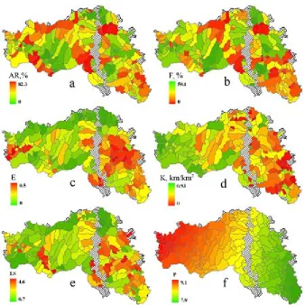
Fig. 2. Spatial differentiation of the main indicators that have been used for typing basins of the Belgorod ecoregion: a – proportion of arable land (AR),%; b -– proportion of forests (F),%; c – ratio of the soil erodibility
the largest share in crops: 49 and 28% of the total cultivated area, respectively; 16.9% is sown with forage crops. With 1.1% of the population, the Belgorod region produces 3.9% of its agricultural products: 10.2% of unrefined sunflower oil and its fractions, 7.6% of white beet sugar in the solid state, 14.3% of pork, 17.8% of poultry meat. Cross-border position of the region contributes to the intensive development of foreign trade.
Structure of the ecoregion and organization of management of natural resources on the basin principles
We have determined that the Belgorod ecoregion is completely or partially formed by 52 river basins, which consist of 188 watersheds of the
4-7th order: they occupy 90.2% of the area. Basins of the ecoregion were divided into two types according to the principle of integrity (Fig. 1):
Type 1. Internal basins, which are completely located within the Belgorod region. There are 135 watersheds of this type, and 57.2% of them belong to the Don River system. Internal basins are the best facilities for management of natural resources on the basin principles and organization of the soil, land and hydrological monitoring, as they are subject to the authority of only one subject of the Russian Federation.
Type 2. Interregional and cross-border basins partly located in Ukraine, the Kursk and Voronezh regions of Russia. This type (53
Fig. 3. Dendrogram of the hierarchical grouping of 188 river basins of the Belgorod ecoregion by the risk of erosion and ecological state: A – the boundary of the detection threshold (D) of basin types,
B – the boundary of the threshold for basin subtypes; I-IV – types, 1.1-4.2 – subtypes
watersheds) accounts for 33% of the territory of the region. Interregional and cross-border rivers are included in the ecoregion according to certain criteria. There are the following criteria for small rivers: the basin area and/or the length of the watercourse in the Belgorod region must be at least 25% of its total area and/or length. This condition does not apply to basins of eight medium-sized rivers (Aidar, Vorskla, Potudan, Psyol, Seim, Quiet Pine, Uda, Black Kalitva) and one big river (the Seversky Donets), the sources of which are located within the region. Basins of such rivers were included in the ecoregion because of their hydrological status. Depending on the location of the source of the river, the type 2 has been divided into two subtypes (2a and 2b).
Subtype 2a – basins of rivers that originate in the Belgorod region and end outside. In this case, the Belgorod region as the subject of management of natural resources will bear greater responsibility, since the ecological and economic situation of the basin will directly affect the state of water resources in adjacent territories;
Subtype 2b – basins of the inflowing rivers with the mouth in the Belgorod region. There are only six such basins, five of them are cross-border. In this case, the state of rivers will be largely determined by anthropogenic influence of the subjects of Russia and Ukraine adjacent to the Belgorod region.
Territory of the peripheral basins that are not included in the ecoregion occupies 3.4% of the area of the region. By virtue of their administrative affiliation, these basins will not be excluded from the management projects, but they cannot be regarded as full-fledged environmental monitoring facilities.
The Oskol River basin (6.4% of the area of the region) has been assigned a special status as a transnational ecological corridor as a communicative infrastructure element of the ecological framework, which is designed to maintain the ecological stability of the territory (Elizarov, 2008).
Fig. 6. Evaluation of the need for environment stabilizing and anti-erosion measures in the basins of the Belgorod ecoregion
For interregional and cross-border basins, it is necessary to solve the problem of interregional and interstate basin cooperation. For basins of related subjects, this can be achieved through the establishment of basin commissions. Transboundary rivers that connect the interests of neighboring countries have a special status. 14 such rivers originate in the Belgorod region, the largest of which are the Seversky Donets, Vorskla, Seim, Psyol, Aidar. The waters of the international river should be used by one side in such a way as not to cause significant damage to the water rights of any other border state in the same river basin. All the issues of water management for such rivers are decided at the international level through the conclusion of international agreements. This way is quite complicated, but there are enough successful examples of its implementation around the world (the Amur, Rhine, Danube, Mekong Rivers, etc.). For Belgorod region, an example of such cooperation is a project on joint use and protection of transboundary river Seversky Donets, in which a system of hydrological monitoring is established within the cross-sections of the rivers on the border between Russia and Ukraine.
Assessment of environmental and resource status of the river basins of the Belgorod ecoregion
The project decisions for the rational management of the natural resources of the ecoregion, based on the principles of the soil and water protection organization of the territory (Lisetskii et al.., 2014a), were based on the results of its ecological assessment. Assessment of the risk of erosion of agricultural landscapes allows to differentiate them by demand in various types of reclamative works, to identify priority areas for anti-erosion and land-use planning and to evaluate the necessary organizational and financial resources. Earlier (Narozhnyaya, 2011), the hydrographic and environmental typing of the Belgorod region on the basin principle was performed. In this study, the focus is made on the rationale for such indicators that would characterize the disposition of territories to the manifestation of water erosion of the soil taking into account the environmental sustainability of watersheds.
Basins typing involves selection of the most informative indicators that take into account the geomorphological, soil, climatic and
environmental conditions. We have selected 7 of these indicators: the proportion of the total basin area: forests (F), arable land (AR), area of slopes of southern exposure (S), as well as the ratio of the soil erodibility (E), relief function (LS), erosion precipitation index (P) and river network density (K) (Table 1). Quantitative and qualitative assessment of parameters was performed by means of modern geoinformation analysis and modeling in software environment ArcGIS 9.2.
Expansion of arable land and forests
Ratio of the proportion of arable lands and forests in the conditions of forest-steppe and steppe gives an overview of the environmental sustainability of each basin. Indicators of the proportion of arable land and forests within the ecoregion (Figure 2a, b) are distributed unevenly, which is caused both by the primary differences in the natural conditions of forest-steppe and forest-steppe (south-east) part of the region and the history of land use.
Soil erodibility
The degree of erodibility is a complex indicator reflecting, on the one hand, the intensity of soil degradation processes and on the other hand, the risk of erosion in a further use of the soil under the current land-use practices. Soil erodibility acts as an additional factor that reduces soil anti-erosion stability. It was found (Shvebs, 1974), that depending on the degree of erodibility, the relative soil washability will increase 1.3-3.5 times.
The index was calculated based on materials of soil and erosion survey of the Belgorod region, presented in the form of electronic maps. Productivity reduction factor was determined for each combination of soil type and its erosion. Calculations of the weighted average degree of erosion (E) for each basin (Figure 2c) were performed using the method of overlay of vector layers with soil and erosion ranges.
River network density
The main reason for the degradation of small rivers is soil erosion in their catchment areas in a changing climate. Many years of intensive surface (slope) and gully erosion on the East European Plain led to the shift of nearly 100 bln ton of sediment to girder-channel network, 90% of which redeposited in the beds of small rivers (Sydorchuk, 1995). The river network density index (K) is a definite indicator of the intensity of erosion processes. In the Belgorod region, the river network density is unevenly distributed (Figure 2d): it is higher in the west, and on average is 0.2 km/km2,
and it reduces further to the east. To determine the K index, the length of the modern river network of the Belgorod region (including permanent creeks) was estimated on the maps at the scale of 1:200,000, which was 4,457 km. The values of K within the Belgorod region vary within wide limits: from almost zero in the southeast, which indicates the absence of permanent water flows in some basins, up to 0.9 in the west, with the regional average value of 0.17 (Table 1).
Relief function and proportion of the area of slopes with southern exposure
Relief function (LS) represents the integral effect of the length and steepness of the slopes on the erosive potential relief (Morgan, 1979). The basins of the eastern part of the ecoregion have the greatest erosion relief potential (Figure 2e), while the watersheds in the northern and southwestern parts of the study area have the smallest. The proportion of the area of slopes with southern exposure S is a supplementary measure and reflects a predisposition of basins to the manifestation of the erosion during snowmelt. It is assumed that if S >25%, the basin relief is characterized by elevated erosive potential in terms of the spring flush of the soil.
Erosion precipitation index
To determine this indicator, the cartogram
of the erosion precipitation index (P) was used, which is characterized as the product of the kinetic energy of the rain on its 30-minute intensity (Figure 2f). Erosion potential precipitation on the territory of Belgorod region uniformly increases from the southeast to the northwest, and varies from 7.8 to 9.1.
Typing river basins by ecological status and predisposition to water-erosion processes
With a large number of the objects under study (188 basins), it is advisable to use automated means of statistical data and methods processing. One of these methods is a multi-dimensional cluster analysis. The higher the level, the lower the degree of similarity between objects in the respective cluster (Figure 3).
As a result of the cluster analysis, separation of river basins in the two major clusters occurred at the highest level of aggregation, where the determining classification feature was the erosion of soil, which undoubtedly represents a response to the totality of the leading factors in water-erosion processes (relief, climate, soils, vegetation, etc.) and the time of exposure. This division is consistent with the physical and geographical division of the Belgorod region: some basins are confined to the subzone of the typical forest steppe, while others – mainly to the steppe zone and southern forest steppe subzone.
At a lower level of association with D=25, the basins are aggregated according to the criteria of human transformation – arable and forest cover. They form four types:
I. Basins with predominantly slightly eroded soils and low agrogenic transformation, where the average proportion of arable land is 30%. This type is the smallest and includes in total 21 basins with total area of 298 thous. ha.
II. Very much plowed basins (67% of arable land) with slightly eroded soils. The type includes 30 basins located in the western and north-eastern parts of the region with a total area of 539 thous. ha.
III. Heavily plowed pools (about 60% of arable land) with slightly eroded soils. With a total area of 702 thous. ha, this type includes 58 basins in the central and western parts of the region.
land) on severely eroded soils. This group forms a separate cluster within the steppe and southern forest steppe zones with much degraded river system (K<0.1 km/km2) and
includes 75 pools with total area of 909 thous. ha.
Grouping by the degree of soil erosion and ploughness gives a perspective of the results of long agrogenic load and its modern values. But for planning the anti-erosion measures, you should also consider the potential for the development of erosion processes, which is expressed primarily in the geomorphological conditions. The semantic analysis showed that the optimal partition, where the main role in typing is played by relief, is achieved by aggregation threshold D=12. At that, the basins are grouped into nine subtypes (Table 2, Figure 4). River basins (n =11) with a wide flood plain and contrast relief of the opposite banks (Nezhegol, Vorskla Rivers and others rivers) were typed using an expert method.
Subtype 1.1. Basins with high forest cover and relatively low ploughness. They have the most favorable ecological and economic conditions, as the areas of forest and arable land are approximately equal. These basins are the standard of ecologically sustainable territories, but their share from the total area of the ecoregion is small – only 9.5%.
Subtype 1.2. Ecologically unsustainable basins, within which the basic units of settlement and industrial development are concentrated: the cities of Belgorod, Shebekino, Stary Oskol, Gubkin and the iron ore mining complex of the Kursk Magnetic Anomaly. These basins are separated from the rest of the inter-settlement areas due to the industrial transformation of their land, which suggests the need for a special type of geoplanning of the system of management of natural resources. Subtype 2.1. Group of basins in the central and north-eastern part of the region (watersheds of the Oskol and Potudan Rivers). They are characterized by very high ploughness (66%) and low forest cover (8%). The basin soils are slightly eroded, the relief and climate conditions are quite favorable (LS=1.7, P=8.3). The peculiarity of this subtype is that a quarter of its territory was influenced by glaciation during the Lower Pleistocene. The source rocks are mainly
represented by water-glacial sand deposits, on which the soils of light granulometric composition were formed. Such areas include basins of the Kotyol, Grjaznaja Potudan and Borovaja Potudan Rivers. Sandy loamy and sandy granulometric composition soils prevailing on them are subject to deflation, which determines the need for a special focus of soil protection measures.
Subtype 2.2. Basins at slightly eroded soils of the forest steppe zone, which, like subtype 2.1, experience intense agrogene load with low forest plantations. The relief of the basins of this subtype is rather favorable (LS=1.7, the proportion of the area of the southern slopes is 21%), which reduces the risk of formation of heavy runoff and surface wash. However, compared with subtype 2.1, the probability of intense precipitation is higher, which is reflected in the value of index P=8.9.
Subtype 3.1. Small basins in the west of the area form two geographically separate groups: the righ ttributaries of the Vorskla (including Vorsklitsa) and right tributaries of the Seversky Donets. This subtype is characterized by an average afforestation and ploughness of more than 45% at very difficult relief conditions. Of special note is a group of Vorskla basins, which exhibit uncharacteristic of the forest steppe zone combination of severely eroded soils with relatively high forest cover of 16%. The reason is that after the forest clearance in XVII-XIX centuries, dark gray forest soils, very susceptible to erosion processes, were actively exploited in this territory, which resulted in the degradation of the soil and the formation of large areas of mildly and severely eroded soils.
Subtype 3.2a. The territorial homogeneity in not characteristic for this subtype of basins: they are usually small in size and are dispersed in the central and western parts of the region. A special feature is the smallest share of the southern slopes of all subtypes (19%), making the river basins of this subtype less vulnerable to erosion during the spring snowmelt.
them lies in the erosive relief potential: this subtype is characterized by higher values of the relief function (LS=2.4) and a greater proportion of the areas of southern exposure slopes.
Subtypes 4.1 and 4.2 include basins of the fourth type with severely eroded soils in the east of the ecoregion and ploughness of more than 50-60%. Forest cover is very low, especially with subtype 4.2, where the lowest proportion of forests was noted – 3.5%. Subtypes 4.1 and 4.2 differ mainly by the risk of relief erosion: for the former, the relief function is the highest of all of the subtypes (LS = 3.1), while for the latter it is slightly less – 2.5.
The typing of river basins within the boundaries of the ecoregion has allowed to determine how the basins are distributed by conditions of anthropogenic load and the risk of erosion (Figure 5.)
Erosional susceptibility of the agricultural landscapes is characterized by two main factors: the relief function and the erosion precipitation index, but the spatial patterns of change in these indicators are opposite: the values of the erosion index monotonically increases in a westerly direction, while increase in the LS values , on the contrary, is observed from a north-west to south-east. Therefore, for the complex reflection of the basin susceptibility to water erosion, it is allowed to multiply these figures as components of a multiplicative model of erosion losses.
Basin subtypes were combined by the risk of erosion, based on the average value of the product LSP. More than 46% of the ecoregion is in the zone of strong and very strong risk of erosion: this includes basins of subtypes 3.1, 3.2b, 4.1, 4.2. Only 20% of the territory is slightly subjected to water erosion – basins of subtypes 2.1 and 2.2.
Need of the basins in the ecoregion in the stabilizing and anti-erosion measures
The general analysis of the ratio of stabilizing and destabilizing lands within the boundaries of the river basins, according to the classification of M.I. Lopyrev (1999), shows that only 8.4% of the ecoregion territory is above the threshold sustainable environmental conditions, under which the share of destabilizing lands (arable land, settlements, industry, etc.) does not exceed 60%. The remaining 91.6% of agricultural landscapes of the ecoregion experience
catastrophic anthropogenic load, more than half of them are located in the ecological state of collapsing. In most cases, high ploughness is the main criterion for the destabilization of agricultural landscapes. In the Belgorod region, the proportion of the total area of arable agricultural land is 75%, while in Europe the figure is less than 57%. In this situation, the most effective tool to improve the ecological balance of the territory is a reasonable reduction of arable land in favor of other lands or ecological fund lands.
In result of the calculations of the necessary reduction of arable land in the Belgorod ecoregion (Table 3), taking into account the risk of erosion, we identified the need of each basin of the ecoregion in the environment stabilizing and anti-erosion measures (Figure 6).
The potential of the reduction of arable land was calculated on the basis of achieving the minimum stability indices at which the share of destabilizing land shall not exceed 50%. It does not take into account the urban basins dominated by the destabilizing territory – lands under construction, infrastructure and industry. The overall estimate of the share of the total destabilizing land in the Belgorod ecoregion is more than 70% of its territory. To achieve the minimum environmental sustainability of the ecoregion, the reduction of arable land by 483.5 thous. ha is required.
erosion-prone slopes -– soil conservation crop rotations. This is the best way to improve the ecological sustainability of arable land without reducing its area. According to the geomorphological analysis, perennial grasses are advisable to place on 410 thous. ha, which is 27% of the arable land. Share of the collapsing agricultural landscapes that dominate today (Figure 5) will be reduced from 67 to 4%. 27% of the territory will be higher than the minimum of environmental sustainability, which is a significant achievement on the way to ecological optimum of the structure of agricultural landscapes of the ecoregion.
In addition, as a way to enhance the greening of arable land, we can recommend measures to increase the proportion of contour anti-erosion forest belts on the slopes, as well as temporary (return) conservation of the severely eroded arable land. Such land should be transferred to long-term deposits. Succession appearing on deposits is characteristic of zonal ecosystems, has significant resource and biosphere potential, and is particularly important for the restoration of soil fertility (Lyuri et al., 2010). The transformation of heavily degraded areas of arable land in other lands is also considered effective. The physical and geographical conditions of the territory should be taken into account: selective afforestation is preferable in the forest-steppe zone, while transformation to natural grasslands – in the steppe zone.
To date, as a result of the implementation of projects related to the basin organization of the territory, 26.2 thous. km2 were offered for
development, which is 96% of the Belgorod region. The proposed measures to increase the stabilizing land will reduce the coefficient of the ecological stress of the area from 2.2 to 1.7. In addition to the environmental and economic effectiveness of the measures on the basin management of natural resources in the region, it is important to consider the consequences that are caused by large-scale changes in the accumulation of organic matter in soils (SOM), carbon sequestration, N, and P cycles (McLauchlan, 2006).
Following the reduction of destabilizing land on the remaining arable land, energy and material resources should be focused on the intensification of agricultural production in order
to obtain the volume of production needed for the sustainable economic development of the region.
CONCLUSION
Evolution of the basin ideas about differentiation of the landscape area by the territorial structures, which are connected by common hydrofunctioning, determines the formation of a new concept – eco-hydrological region (abbreviated to ecoregion). Ecoregion is an integral natural and economic formation relatively isolated in respect hydrographic and hydrologic, Ecoregion is the optimal object of geoplanning on basin principles and organization of a multi-level system for monitoring water and land resources.
structure of the land fund and improvement of the ecological balance of the area is a reasonable reduction of arable land in favor of other lands or ecological fund lands. The result of the study is the assessment of the needs of each basin in anti-erosion and water conservation measures and a set of tailored measures to improve the ecological sustainability of agricultural landscapes.
ACKNOWLEDGMENTS
This study was supported by Russian Science Foundation (project No 15-17-10008).
REFERENCES
1. Antipova, A.V., Kochurov, B.I., Kostovska, S.K., & Lobkovsky, V.A. (2002). Russian ecoregions: zoning of the country by environmental and socio-economic situation.
Ecological Systems and Devices, 4, 14-19. 2. Bolstad, P.V., & Swank, W.T. (1997).
Cumulative impacts of land use on water quality in a southern appalachian Southern Appalachian watershed. Journal of the American Water Resources Association,33(3), 519-534. 3. Buryak, Zh.A., Grigoreva, O.I., & Pavlyuk,
Ya.V. (2014). GIS maintenance of rural territories geoplanning under basin principles. International Journal of Advanced Studies, 4(2), 56-60. http:/ /dx.doi.org/DOI: 10.12731/2227-930X-2014-2-8.
4. Directive 2000/60/EC of the European Parliament and of the Council of 23 October 2000, establishing a framework for Community action in the field of water policy. (2000). Official Journal of the European Communities, 327(43),
1-73.
5. Elizarov, A.V. (2008). Ecological framework – strategy of the management of steppe natural resources in the XXI century. Samara Bend: Problems of Regional and Global Ecology, Vol. 17, (2,), 289-317.
6. Ermolaev, O.P., Mal’tsev, K.A., & Ivanov, M.A. (2014). Automated construction of the boundaries of basin geosystems for the Volga Federal District. Geography and Natural Resources, 35(3), 222-228. DOI: 10.1134/ S1875372814010120.
7. King, R.S., Baker, M.E., Whigham, D.F., Weller, D.E., Jordan, T.E., Kazyak, P.F., & Hurd, M.K. (2005). Spatial considerations for linking watershed land cover to ecological indicators in
streams. Ecological Applications, 15(1), 137-153.
8. Kochurov, B.I., D.Yu., Antipova, A.V., Kostovska, S.K., & Lobkovsky, V.A. (2002). Zoning of the territory of Russia by the environmental and socio-economic situation.
Geography and Natural Resources, 2, 5-11. 9. Kochurov, B.I., Shishkina, D.Yu., Antipova,
A.V., & Kostovska, S.K. (2009). Geoecological mapping: study guide for university students (ed. B.I. Kochurov, pp. 192). Moscow: Academy. 10. Korytny, L.M. (2006). Administrative territorial
division of Russia: the basin variant. Geography and Natural Resources, 4, 29-37.
11. Kuzmenko, Ya.V., Lisetskii, F.N., Kirilenko, Zh.A., & Grigorieva, O.I. (2013). Ensuring optimal water conservation forest cover in the basin organization of the management of natural resources. Proceedings of the Samara Scientific Center of the Russian Academy of Sciences, Vol.
15(3(2), 652-657.
12. Lisetskii, F.N., Degtyar, A.V., Narozhnyay Narozhnyaya, A.G. et al. (2013a). Basin approach to management of natural resources in the Belgorod region (ed. Lisetskii, F.N., pp. 89). Belgorod: Constanta.
13. Lisetskii, F.N., Pavlyuk, Ya.V., Kirilenko, Zh.A., & Pichura,V.I. (2014b). Basin organization of nature management for solving hydroecological problems. Russian Meteorology and Hydrology,
39(8), 550–-557. DOI: 10.3103/ S106837391408007X.
14. Lisetskii, F.N., Zemlyakova A.V., Terekhin E.A.,
et al.. New opportunities of geoplanning in the rural area with the implementing of geoinformational technologies and remote sensing. Advances in Environmental Biology,
2014a; 8(10): 536-539.
15. Lopyrev, M.I., Shevchenko, V.E., Zezyukov, N.I., & Fedotov, V.A. (1999). Design and implementation of eco-landscape systems of agriculture in the agricultural enterprises of the Voronezh area (ed. Lopyrev, M.I., pp. 186). Voronezh: Istoki.
16. Lyuri, D.I., Goryachkin, S.V., Karavaeva, N.A., Denisenko, E.A., & Nefedova, T.G. (2010).
Dynamics of Russian agricultural land in the XX century and postagrogenic revegetation and soil remediation (pp. 416). Moscow: GEOS. 17. Mal’tsev, K.A., & Ermolaev, O.P. (2014). Using
DEMs for automatic plotting of catchments.
Geomorfologiya, 1, 45-53.
19. Morgan, R.P.C. (1979)). Soil Erosion (pp. 113). London, New York: Longman.
20. Moss, B. (2008). The Water Framework Directive: total environment or political compromise? Science of the Total Environment,
400(1), 32-41.
21. Narozhnyaya, A.G. (2011). Environmental and energy evaluation of agricultural landscapes in their adaptive land management (abstract from thesis of Candidate of Geography, pp. 22). Belgorod: BSU pPublishing hHouse.
22. Shvebs, G.I. (1974). Formation of water erosion of the sediment yield and its evaluation (pp. 184). Leningrad: Gidrometeoizdat.
23. Spesivy, O.V. (2013). Structural and functional
analysis of the watersheds of Central Chernozem region for the purposes of environmental management. Modern Problems of Science and Education, 6: 949(8).
24. Sydorchuk, A.Yu. (1995). The erosion-accumulative processes in the Russian Plain and the problems of silting of small rivers.
Proceedings of the Academy of Hydroeconomic Sciences, 1, 74-83.