iMALERT – an Emergency Response Mobile
ApplicationUsing Geo-Location for Palayan City
Disaster Risk Reduction and Management Office
Oscar P.Oganiza, Maelyn P. Reselva, Jayson Paul V. Vicencio, Rolando
C.Casim, Gener S. Subia
Abstract— The researchers developed an Interactive Mobile Application for Less Emergency Response Time
(iMALERT), a mobile application, aimed to aid in the emergency response activities of Palayan City Disaster Risk Reduction and Management Office ( DRRMO) through real-time incident reporting. The mobile application is equipped with a web-based database server managed by the said office where the emergency incident reports are sent for assessment of the necessary and appropriate response activity. Using four of the five processes of Software Development Lifecycle, the researchers were able to conceptualize, design, develop and stabilize the features of the mobile application and database which were evaluated by expert and non -expert respondents as a reliable tool for emergency case reporting and response in terms of functionality, accuracy, service and usefulness and security and maintenance.
Keywords— Disaster-risk reduction, emergency response, geo-location, mobile application, web-based database.
I. INTRODUCTION
Emergencies are scenarios which need an immediate response because human lives and properties are at risk. The cause of these scenarios varies like disasters, road accidents, fires, and medical emergencies. Disasters alone are a major cause of emergency in the Philippines because the country is at high risk from cyclones, earthquakes, floods, landslides, tsunamis, volcanic eruptions, and wildfires and since 1990, more than 500 natural disaster events claimed about 70,000 Filipino lives and an estimated $23 billion in property damages [1].
According to INFORM, a global open-source risk assessment for humanitarian crises and disasters which rates key factors on a scale of 1 to 10 with ten being the highest, the Philippines has hazard exposure rate of 8.8 and ranks third on 191 assessed countries, meaning the country is at a high exposure to natural disasters. However, the coping capacity is rated as 4.3 and ranks 104th of the countries which signify the lack of response from the concerned agencies of the government [2]. Moreover, road accidents have been a global problem, and in the Philippines death tolls due to road crashes have been rising. According to the latest data available from the Philippine Statistics Authority, 10,012 people died from road accidents in 2015, which is
one of the leading causes of deaths among 5 to 24 year-olds [3]. Meanwhile, fire tragedies, including building and house fires and wildfires also add to emergency concerns because of its unexpected nature.
In Palayan City, the Disaster Risk Reduction and Management Office (DRRMO) which was functional in 2017, have been mandated by its local government unit on the first-hand response on these emergencies in partnership with other local agencies such as the police, the fire bureau and the health office. In the past two years of operation, the office had been depending on their response activities from the citizens' reports through SMS and calls and response time is often delayed due to miscommunication and lack of incident details. Moreover, the office has difficulty in documenting and archiving reports which may be used for future references.
International Journal of Advanced Engineering, Management and Science (IJAEMS) [Vol-5, Issue-7, Jul-2019] https://dx.doi.org/10.22161/ijaems.573 ISSN: 2454-1311
sensors” who report to the DRRMO any emergency cases
needing immediate response.
Although, there are many existing mobile applications concerning emergency response as presented in different studies [4], the researchers had developed a localized integration of technology that will greatly help the response management team by taking advantage of smartphones’ location sensing capability through Global Positioning System and a database system with QGIS platform, an open-source software for geographic information system [5] for further information on the location’s topology (i.e. mountains, body of waters, low-leveled plains) in order for them to have a better assessment of the emergency case. With this system, the emergency response time will be optimized because time engaged will be reduced between the respondent and the office. Additionally, documenting and archiving of reports for future reference will be automatically available from the database.
With these scenarios, this study aimed to answer the following questions: how will the mobile application be developed through the following SDLC processes : inception, design, development, and stabilization? And how will the mobile application be evaluated in terms of functionality, accuracy, service and usefulness, and security and maintenance?
II. METHODOLOGY
This study utilized the developmental research design [6] using the four of the five SDLC model processes – Inception, Design, Development, and Stabilization in the development of iMALERT. The fifth process, which is the Deployment phase that involves the actual hand -off of the mobile application to the research locale and the concerned organization, was not included in this study.
Starting with inception or conceptualization, an idea is refined into a solid basis for an application. The design phase consists of defining the application’s general layout, functions, and user interface. The actual building of the application happens in the development phase. System testing and bug fixes comprise the stabilization phase wherein, and a wider user audience is given a chance to use, evaluate and provide feedback on the application’s
functionality, accuracy, service and usefulness and security and maintenance [7].
Inception
The researchers conducted a visit on the Palayan City DRRMO to assess its present-day emergency response capabilities. This information will be needed in conceptualizing the essential functionalities of the mobile application. As assessed, the current incident reporting of emergency cases is done through phone calls and text messaging, which often causes miscommunication on incident details thus, resulting in the delay of response. Additionally, the office has no evident archive of past emergency incidents which could be used for statistical analysis of the community’s capacity to handle emergencies.
Based on the data gathered, the researchers came up with the following mobile application functionalities:
1. An image/video capture capability for real-time visualization of the emergency
incident.
2. Location tagging enhanced with QGIS for an accurate incident location and geographic information.
3. Web-connected database for incident report management and archiving.
Design
Fig.1: Conceptual Framework of the Functionalities and Features of the Mobile Application and the Web Database
The mobile application’s interface is simple and user-friendly for everybody’s ease of use. The Home screen (Figure 2) is composed of text fields asking for the user’s e-mail address, and preferred password as well as an option to Register or Sign In. Clicking the Register button will switch to the Profile screen (Figure 3) which is composed of text fields asking for the user’s information such as contact number and his/her first and last name. If the user has already an account, clicking the Sign In button will log into his/her account. The mobile application will then direct the user to the Camera window (Figure 4) wherein the user can take photo/video of an emergency scenario. This screen has a Camera button for capturing the incident, a Profile icon that allows to access, edit and add information on the user’s account information, a Report icon that will display the chronological lists of reports that have been arranged and created with complete date and time, location and its status as pending, dispatched or completed (Figure 5), and lastly a Next button that will direct to the Report Incident screen (Figure 6). In this screen, the user can now classify the type of emergency happened and add any necessary information on the incident and pressing another Next button will show a dialog box confirming the submission of the report.
Meanwhile, the web-based server (Figure 7) is composed of a QGIS platform map wherein received reports will pop -up in the form of a notification pinned on the tagged location of the report. Upon clicking this notification pin, complete details of the incident will be displayed on the right side of the screen.
International Journal of Advanced Engineering, Management and Science (IJAEMS) [Vol-5, Issue-7, Jul-2019] https://dx.doi.org/10.22161/ijaems.573 ISSN: 2454-1311
Fig.3: Profile Screen
Fig.4: Camera Window
Fig.5: Report Screen
Fig.7: The Website Database with QGIS Map
Development
The mobile application's user interface and the script was developed through Node.js, an open source platform for scalable applications which was often equipped with web servers. Additionally, the database system was constructed using MongoDB, a member of the NoSQ database family, which stores structured data making integration of information with applications easier and faster [8].
Stabilization
To assess the mobile application’s capability on emergency incident reporting, questionnaires were handed to 20 experts who were engineers, information technologists, and Palayan City DRRMO officers and 100 non-experts who were residents of Palayan City. The questionnaire was composed of questions thatevaluated the mobile application in terms of its functionality, accuracy, service and usefulness and security and maintenance in a four-rating Likert scale. The responses were tabulated and computed using the weighted mean and were interpreted using the scale shown in Table 1.
Rating Scale
Verbal
Description Interpretation
3.25 – 4.00
Strongly Agree
The application is very
functional/accurate/useful/secure. 2.50 –
3.24 Agree
The application is
functional/accurate/useful/secure.
1.75 –
2.49 Disagree
The application is not
functional/accurate/useful/secure. 1.00 –
1.74
Strongly Disagree
The application is not very functional/accurate/useful/secure.
III. RESULTS AND DISCUSSION
Development of iMALERT
The researchers had developed the mobile application iMALERT, which was conceptualized and tailor-made for the emergency response services of Palayan City DRRMO. By using the SDLC model, the researchers were able to incorporate the mobile application's features, which were based on the needed functionalities of an effective emergency incident reporting and response.
International Journal of Advanced Engineering, Management and Science (IJAEMS) [Vol-5, Issue-7, Jul-2019] https://dx.doi.org/10.22161/ijaems.573 ISSN: 2454-1311
real-time location and geographical information as s hown in the web site's map in QGIS platform and whenever the office wants a statistical analysis of the emergency incidents for a certain period, incident reports are readily available and retrievable in the database in a structured tabular format.
Assessment of the Mobile Application
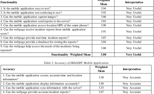
As shown in Table 2, which assesses the mobile application’s functionality, the respondents agreed that the mobile application is very easy to use (WM=3.94), and it can be noted that the weighted mean of all the items on the list is beyond the 3.8 mark which means that the respondents strongly agree on the functionalities of the mobile application.
On Table 3, the accuracy of information being sent and received from the mobile application to the web database is very accurate, as seen in the over-all weighted mean (WM=3.49). Although, the item about the syncing of data
from the mobile application with the database has the lowest weighted mean of all the items (WM=3.33) it is still within the very accurate range.
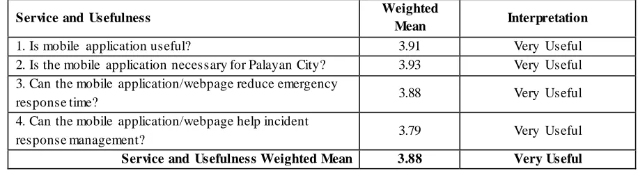
Moreover, the mobile application’s service and usefulness were presented in Table 4. The respondents strongly agree that the mobile application is very useful, and it is indeed essential in the emergency response activities of Palayan City (WM=3.91 and WM=3.93). Also, the respondents thought that emergency response time and management were reduced (WM=3.88 and WM=3.79). Lastly, Table 5 shows the security of information – user's data on the mobile application and archived incident reports on the database. The respondents believed that their personal information is very s ecured (WM=3.63). The item on the ease of maintenance of the database got the lowest weighted mean of all the items from the table, but it still on the favorable range (WM=3.17).
Table 2. The functionality of iMALERT Mobile Application
Functionality Weighted
Mean Interpretation
1. Is the mobile application easy to use? 3.94 Very Useful
2. Is the mobile application not confusing to use? 3.92 Very Useful
3. Can the mobile application capture images? 3.86 Very Useful
4. Can the mobile application send reports to the server? 3.83 Very Useful 5. Can the mobile application access location/GPS of the smart phone? 3.90 Very Useful 6. Can the webpage receive incident reports from mobile application
users? 3.91 Very Useful
7. Can the webpage provide real-time incident reports? 3.87 Very Useful 8. Can the webpage provide a database for storing the reports? 3.84 Very Useful
9. Can the webpage help assess the needs of the incidents being
reported? 3.88 Very Useful
Functionality Weighted Mean 3.88 Very Useful
Table 3. Accuracy of iMALERT Mobile Application
Accuracy Weighted
Mean Interpretation
1. Can the mobile application secure, accurate time and location
information? 3.38 Very Accurate
2. Can the mobile application display information accurately? 3.58 Very Accurate 3. Can the mobile application sync information with the server? 3.33 Very Accurate 4. Can the webpage provide accurate incident reports? 3.67 Very Accurate
Table 4. Service and Usefulness of iMALERT Mobile Application
Service and Usefulness Weighted
Mean Interpretation
1. Is mobile application useful? 3.91 Very Useful
2. Is the mobile application necessary for Palayan City? 3.93 Very Useful 3. Can the mobile application/webpage reduce emergency
response time? 3.88 Very Useful
4. Can the mobile application/webpage help incident
response management? 3.79 Very Useful
Service and Usefulness Weighted Mean 3.88 Very Useful
Table 5. Security and Maintenance of iMALERT Mobile Application
Security and Maintenance Weighted
Mean Interpretation
1. Is the mobile application/server capable of securing
information? 3.46 Very Secure
2. Is the mobile application/server easy to maintain? 3.17 Secure
3. Is the database secured? 3.34 Very Secure
4. Are the user profile information secured? 3.63 Very Secure
Security and Maintenance Weighted Mean 3.40 Very Secure
IV. CONCLUSIONS AND
RECOMMENDATIONS
iMALERT is an innovative way of integrating technology into the current emergency response process. With this application, emergency incident reporting was made as soon as it happened to inform the concerned agency with the real-time and accurate incident information thus, the response was quicker and effective preventing the scenario to worsen or to claim casualties. The evaluation of iMALERT mobile application has an over-all total weighted mean of 3.66 which means the respondents strongly agree that the application and database have the necessary functionalities of an effective emergency response system; the application and database have a high level of accuracy when it comes to data included in the emergency incident report; the application and database are very easy to use and can be beneficial to the Palayan City community; and the application and database have high security on sensitive user account data and archived incident reports.
Based on the conclusions, the researchers recommend this mobile application to be introduced not only to the citizens of Palayan City but also to all other communities because an effective emergency response means properties and lives are saved.Since this mobile application is made on a scalable platform, it is open for future innovations and improvements particularly integration to the upcoming 5G
network technology for a more efficient and more interactive emergency incident reporting and response. Further, it is recommended that Electronics and Computer engineers and Information Technology experts to venture on studies that are related to this study and continue to investigate and evaluate the technique [9] introduced by the researchers for further improvement of the system.
Lastly, since this study investigated only [10] the respondents in Palayan City, its findings do not translate to the entirety of all the people in the province of Nueva Ecija. Thus, the researchers suggest that additional studies involving more respondents and more areas should be done to further strengthen the result of this research.
REFERENCES
[1] The Philippines is at high risk from cyclones, earthquakes, floods, landslides, tsunamis, and wildfires. (n.d.). Retrieved from https://www.gfdrr.org/en/philippines/
[2] Philippines. (2018). Retrieved from http://www.inform-index.org/Countries/Country -Profile-M ap/
[3] Sy, Kimiko. (2017, November 2). IN NUM BERS: Road crash incidents in the Philippines [news article]. Retrieved
from:
https://amp.rappler.com/move-ph/issues/road-safety/166151-road-crashs-philippines-awareness-safety/
[4] Bachmann, Daniel J. et. al., (2015). Emergency
International Journal of Advanced Engineering, Management and Science (IJAEMS) [Vol-5, Issue-7, Jul-2019] https://dx.doi.org/10.22161/ijaems.573 ISSN: 2454-1311
that. Prehospital and disaster medicine. 30. 1-5. 10. 1017/S1049023X15005099.
[5] QGIS A free and Open Source Geographic information System. (n.d.). Retrieved from https://www.qgis.org/en/site/
[6] Subia, Gener S. (2018). Think Like M y Teacher (TLM T): A New M ethod in Assessing M illennial Learners. International Journal of Arts, Humanities and Social Sciences.Volume 3. Issue 1.www.ijahss.com
[7] Burns, Amy et. al., (2016).Introduction to the M obile
Software Development Lifecycle. Retrieved from:
https://docs.microsoft.com/en-us/xamarin/cros-platform/get-started/introduction-to-mobile-sdlc/
[8] Cuomo, Jerry , (2013). Javascript Everywhere and the Three
Amigos [blog post]. Retrieved from:
https://www.ibm.com/developerworks/community/blogs/gcu omo/entry/javascript_every where_and_the_three_amigos?la ng=en/
[9] Subia, G.S.(2018). Comprehensible Technique in Solving Consecutive Number Problems in Algebra. Journal of
Applied M athematics and Physics, 6, 447-457.
https://doi.org/10.4236/jamp.2018.63041