c
Evaluation of Fractal Dimension and Topographic Surface Roughness (Vertical Dissection) in
Astore-Deosai-Skardu Region in GIS Environment Using ASTER GDEM
Amer Masood,
1 *Syed Amer Mahmood,
1Muhammad Khubaib Abuzar,
1Abid Ali,
2Ahmed Muneeb Mehta,
3Muhammad Shafiq
41 Department of Space Science, University of the Punjab, Lahore, Pakistan
2Department of Earth and Environmental Sciences, Bahria University, Islamabad, Pakistan
3Hailey College, University of the Punjab, Quaid-e-Azam Campus, Lahore, Pakistan
4Pakistan Space and Upper Atmosphere Research Commission, Karachi, Pakistan
*Email:[email protected]
Received: 31 August, 2019 Accepted: 06 September, 2019
Abstract: Fractal investigation isa valuable technique to model and quantify the composite patterns of natural similar objects. This study investigates Neotectonics using ASTER-GDEM. Fractal technique for extraction of topographic
fractal dimension (Dtopo) and vertical dissection (Rtopo-surf) were used to assess the Neotectonics deformation.
Geomorphological regions can be demarcated by using above mentioned procedures as they reveal the topographic evolutionary stages as an evaluation of topographic textures. The idea is to recognize the zones that are strongly influenced by Neotectonics. Astore-Deosai-Skardu (ADS) region in Gilgit-Baltistan was selected for this purpose as it lies between MKT and MMT which is experiencing surface topographic deformation (STD) caused by anti-clock-wise
progression and subduction of Indian plate beneath Eurasia. The results obtained illustrates that Dtopo and Rtopo-surf show
anomalies in the ADS region that clearly represent a robust control of nearby MMT, MKT and KkF and highlights their significance to describe regions vulnerable to Neotectonics and related deadly events threatening precious human lives and infrastructure damages.
Keywords: ASTER-GDEM, fractal, vertical dissection, Neotectonics, ADS, Gilgit-Baltistan.
Introduction
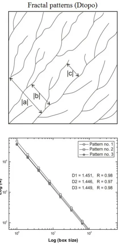
Fractal measurements are complementary in nature and they compute self-similarity and complexity in a geospatial feature like stream network (Fig. 1, Mandelbrot, 1977; Mahmood and Gloaguen, 2011).
The Dtopo shows to what extent spatial texture covers
an essential space in metrics. The Rtopo-surf is a
significant landscape metric (Olaya, 2009) and have been tested in planetary and the geosciences (Hobson, 1972) to spot both distinctive landforms and assess the influence of endogenous/exogenous processes over them. For instance, age-roughness relationships are utilized to demarcate landslide types from various epochs (Mckean and Roering, 2004, Carvalhido et. al., 2016), alongwith parameterization of different hydrological-models for drainage flow (Mason et al., 2003). In morphotectonics (Olaya, 2009; Pike et al., 2009, Von Ahn and Simon, 2017; Nazaruddin, 2017; Üner et. al., 2017; Erikstad et. al., 2018; Ruban et. al., 2018; Piacentini et. al, 2019; Tang, 2019; Mikhailenko
and Ruban, 2019) Rtopo-surf is illustrated through
topographic elevation values (TEVs) and are utilized to categorize landforms at variety of scales and with different moving window sizes as shown in (Fig 2).
In this investigation, we use Rtopo-surf in terms of the
inconsistency of topography at a known scale, while the investigation scale is computed with respect to the landform size or geomorphometric spatial texture of significance. The above-mentioned investigations allow the examination of geo spatial textural properties
of the drainage flows and can assess the STD. Dtopo and
Rtopo-surf were applied for the drainage system of ADS
region (Figs. 3, 4). Following are the objectives of this
investigation; 1), to produce a Dtopo map from
ASTER-GDEM for the streams and topography of ADS region to demarcate zones connected to endogenic and
exogenic forces, 2) To generate Rtopo-surf map for the
delineation zones in the examination region being influenced by the tectonic forces using DEM, 3)
investigation of relationship between Dtopo and Rtopo-surf
and their variabilities in the research area.
Climate, Topography and Geology
Eastern part of ADS lies in the moist region of western Himalayas. Highest temperature in summer remains up to 20-25° C while lowest during winter remains below -10° C. Maximum rainfall is between 25-30 mm during February to March. The mountains are much steepened with less vegetal cover. The Indus, Astor and Bara Pani are major rivers that eventually join Indus river that flows in east-west direction in the region. South Asian monsoons seldom enter this region and most of the precipitation is from westerlies, with 40-45% only during March-to-May and heavily in April (Soncini et al., 2015). West of Ladakh, Deosai Mountains comprises both young granite rocks and Precambrian rocks. South of Skardu, the famous Deosai pleateau (world second largest, extends 120-190 km from the Indus river bend at Bunji to the Suru (Karcha) river, that separates it from the Zaskar Range is located with outcrops of Deosai volcanics (Desio, 1978).
ISSN: 2223-957X
These volcanics are comparable to tholeiites to calc-alkalines Dras-volcanics in Indian held Kashmir of Late Jurassic-to-Cretaceous age and can be connected with the Chalt-volcanics of Kohistan island-arc similar chemical composition (Searle, 1999). Burji-La-Formation (Late Cretaceous) in the north of Deosai plateau overlies volcanics of Deosai in the study area (Figs. 3, 4, 5).
Fig.1 Diagram showing fractal dimension mechanism.
Shows reported and newly confirmed faults in the study area. GPS velocity vectors (Red) with respect to Eurasia fixed reference frame, the purple vector is transformed with respect to India fixed. Abbreviations of fault names: DkF, Darvaz Karakul Fault, AM, Alburz Marmul, CbF, Central Badakhshan Fault, HvF, Henjvan fault, HF, Herat Fault, CF, Chaman Fault; MoF, Mokar fault, GzF, Gardez Fault, KoF, Konar Fault, SBF, Sulaiman Base front, MBT, Main Boundary Thrust; MFT, Main frontal thrust, MMT, Main Mantle Thrust, and MKT, Main Karakoram Thrust, Reshun Fault, TMF, Tirch Mir Fault, SF,
Sarobi Fault, ST, Spinghar Thrust, AF, Andarab Fault, TbF, Tarbella Fault, BgF, Bazgir Fault.
Fig. 2 Diagram shows variations in Rtopo-surf with respect to different
moving-window-sizes and DEM resolution.
Materials and Methods
ASTER-GDEM based binary image was created, after filling pits using D8 and filling algorithm by
(O’Callaghan and Mark, 1984,). The Dtopo technique
represents the complexity of stream textures. Rtopo-surf
is described as of the variations of elevation values, commonly articulated as the deviation from a best-fit surface plane (Fig. 6) (Arrell and Carver, 2009). Standard deviation for the remaining topography was
utilized as a gauge of Rtopo-surf (Haneberg, 2007), where
the remaining topography represents the difference between the smoothed DEM and original plane.
Fig. 4 Map showing study area with local lineaments and seismic events.
Results and Discussion
Dtopo and Rtopo-surf
The geospatial channel network in an active topographic environment is constantly influenced by variations in the drainage geometry type due to most recent seismic events of both regional and local lineaments. In the province of Gilgit-Baltistan (GB) in north-north-east of Pakistan, the whole stream network are experiencing severe tectonic control with the exception few zones in Deosai region. Spatial channel system encloses huge prospective to preserve erosional/tectonic signs of processes that cause active deformation. Geospatial distribution of stream geometries in the ADS region of GB are of three types i.e., disconnected, parallel and dendritic form. Such variations in transitional geometrical transformations at different stages and textural developments from one spatial type to the other are indebted to the spatiotemporal phenomena (geological, neotectonic and climatic). Parallel stream textures are developed in an extremely steep zone and it is a confirmation of neotectonic impact. The virtual uplift scenarios in a localized zone result in a steep slope topography forcing the geometry of the channels to become linearized means neotectonic uplift. In a composite tectonic environment, the spatial stream geometry transforms into disjointed and rugged stream shapes. Geospatial streams track the fundamental fractal behaviour, remained uninterrupted and are separated by fractal dimension and topographic surface
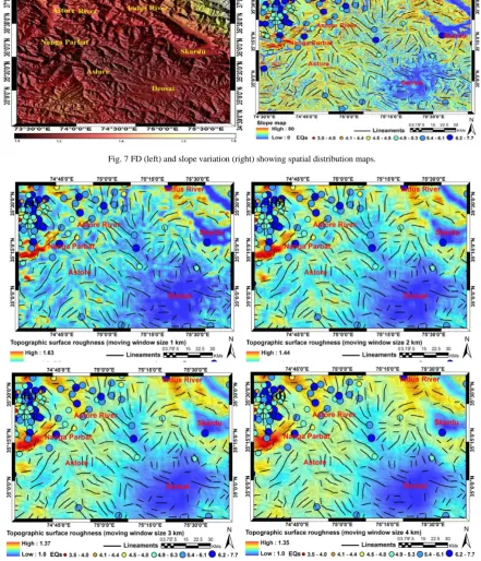
roughness, i.e, Dtopo, Rtopo-surf and aspect map (Figs. 7,
8).
The lower Dtopo values in ADS region propose the
charisma of active scheming processes (differential erosion and comparative neotectonic evolution and uplift) on the topographic ADS evolution of landscape.
Dtopo map reveals majority ADS region in GB is
characterized by low-to-very lower Dtopo values that
Fig. 5 Geological map of Astore-Deosai-Skardu region.
Fig. 6 Schematic diagram showing calculations of DEM based R
topo-surf.
show that ADS region is medium to highly rugged and regional tectonics are scheming localized stream
network. Higher Dtopo values are observed NE of
Skardu (where the streams are non-linear) due to existence of stable glaciers and snow pack regions. These high values indicate the spatial drainage pattern are more dendritic and are controlled mostly by glacial erosion processes having lower inclination to STD.
Another higher Dtopo value is observed in upper Astore
region in the south of the investigation site due to dendiritic stream geometry and existence of snow deposits and glaciers. An abrupt change in a spatial
While the assessment of gap-fillings within stream textures, it is complex to discern amongst the stream textures with unlike unfilled gaps distribution. Spatial
streams can reveal analogous Dtopo values, but
unoccupied gaps between them are distributed in a
different way. The zones showing similar Dtopo values
may be further differentiated and examined on the basis of their translationally invariant behavior (TIB)
Geospatial allocation of Dtopo and Rtopo-surf values for
ASD region are consistent with the regional structures and their orientations.
Rtopo-surf is computed by moving window of different
sizes (1, 2, 3 and 4 km) over the ASTER-GDEM with spatial resolution of 30 m, are presented. Shades of
blue and cyan correspond to relatively plain areas
(lower Rtopo-surf Deosai and Skardu zones),
yellow-indigo tones to intermediary values (medium Rtopo-surf ;
Astore region) and orange-red to rough areas (higher Fig. 7 FD (left) and slope variation (right) showing spatial distribution maps.
Fig.8(a) Rtopo-surf with moving window of 1km, 8(b) Rtopo-surf with moving window of 2 km, 8 (c) Rtopo-surf with moving window of 3 km, 8(d) R
Rtopo-surf ); NNW of Skardu, North of Astore and
Nanga Parbat zone). The prevalence of cyan-tones in relatively low relief shows that this technique fails to differentiate elevations features with similar values. Scarps of SRFZ (Sassi-Raikot-Fault-Zone) in Nanga
Parbat region are distinct with high Rtopo-surf values,
because they show steep slopes and angles, yet they are considered as inclined (smooth) surfaces. Vegetal and urban areas demonstrate average middle to lower Rtopo-surf values (Yellow-indigo-cyan-blue tones). This
technique is also responsive to localized and robust variations in elevation, which is due to spurious datasets. Fault scarps of the SRFZ near Nanga Parbat, lower Astore and Skardu are correctly recognized as
smooth regions, with higher Rtopo-surf values observed
over the breaks in slopes, signifying the suitability of Rtopo-surf technique for terrain investigation. Our
investigations reveal that for a given area ratio, broad
spatial patterns distribution of Rtopo-surf remains
unchanged (Fig. 8a, b, c, d). The NW and SE scarps of SRFZ near Nanga Parbat maintain medium to low Rtopo-surf values, as DEM resolution reduces and the
zones of medium to higher Rtopo-surf values in the SE
region (Deosai and Skardu) tend to be removed as topographic landforms befall generalized. In the SE region, the existence of open fields (smooth areas) and rough vegetal/urban features provides mixed results with decrease in DEM resolution and increase in window size.
Conclusion
The fractal dimension and topographic roughness
(Dtopo and Rtopo-surf) are invaluable tools for the
quantification and description of the spatial stream textures, its topographic evolution, transitional stages developments in the ADS region in GB-northern
Pakistan. The lower Dtopo, values depict the geospatial
anomalies ascribed by the spatial stream textures that propose generally the neotectonic command in the ADS region and moreover higher tendency to STD.
The Dtopo has tremendous potential to predict the
comparative distribution of STD. The stream textures of the GB are revealing disconnected, parallel and dendritic spatial trends that are indicators of ongoing neotectonic control in ADS region. The tectonic induced uplifted zones in the context of great variations in linearization, orientation and
homogeneity can be distinguished by Dtopo analysis.
Based on fractal measures, it is deduced the ADS region is facing severe STD in the view of Indo-Pak plate subduction beneath Eurasian plate in concurrence with medium to large magnitude earthquakes.
Rtopo-surf is generally employed as a descriptive
variable in planetary and geosciences. It depends upon substance characteristics, recent, palaeo processes and the time intervenes ever since its formation. Numerous
measures of Rtopo-surf and slope in degrees have been
executed using GIS, river tools, geomatica, Envi and Matlab platforms. The extensive and frequent availability of DEMs permits the rapid and economical
multi-scale investigation of Rtopo-surf and slope in
degrees and provide excellent results, revealing majority of terrain features. The ADS region is by and large evolving and uplifting because of the change of rotation (from initially clockwise to recent anti-clockwise direction) of Indo-Pak continental plate against Eurasia. The ADS region, specially, Nanga
Parbat-SRFZ with highest Rtopo-surf and steep slopes
ever recorded on the planet earth is still experiencing the severe STD.
Acknowledgement
The authors are thankful to the Department of Space Science, University of the Punjab, Lahore, for providing necessary facilities for conducting this study. The authors are grateful to Earth Remote Sensing Data Analysis Center (ERSDAC) of Japan and the Japanese Ministry of Economy, Trade and Industry (METI) for providing ASTER GDEM data.
References
Arrell, K.., Carver, S. (2009). Surface roughness
scaling trends. In Geomorphometry 2009
Conference Proceedings, University of Zurich, Switzerland, 120-123 pages.
Carvalhido, R. J. Brilha, J. B. Pereira, D. I. (2016). Designation of natural monuments by the local
administration: The example of viana do
castelo municipality and its engagement with
geoconservation. Geoheritage,8 (3), 279–290.
Desio, A. (1978). On the geology of the Deosai plateau
(Kashmir): Accademia nazionale dei Lincei.
Erikstad, L., Nakrem, H. A., Markussen, J. A. (2018). Protected geosites in an urban area of Norway,
inventories, Values, Management. Geoheritage,
10 (2), 219–229.
Haneberg, W. C. (2007). Large-scale terrain visualization using SRTM digital elevation models: an example from the Indian Himalaya. In Geological Society of America Annual Meeting.
Hobson, R. D. (1972). Surface roughness in
topography: quantitative approach. In Chorley, R.
J., (eds.) Spatial analysis in geomorphology, Methuer, London, 225-245.
Mahmood, S. A., Gloguen, R. (2011). Analyzing spatial autocorrelation for hypsometric integral to discriminate neotectonics and lithologies using
DEMs and GIS. GIS and Remote Sensing, 48 (4),
541-565.
Mandelbrot, B. B. (1983). The fractal geometry of
Nature,W. H. Freeman, New York.
two-dimensional river flood models using vegetation heights derived from airborne scanning
laser altimetry. Hydrological Processes, 17 (9),
711-732.
Mckean, J., Roering, J. (2004). Objective landslide detection and surface morphology mapping using
high- resolution airborne laser altimetry.
Geomorphology,57, 331-351.
Mikhailenko, A.V., Ruban, D. A. (2019). Geo-heritage specific visibility as an important parameter in
geo-tourism resource evaluation. Geosciences, 9,
146.
Nazaruddin, D. A. (2017). Systematic studies of geoheritage in Jeli district, Kelantan, Malaysia.
Geoheritage,9, 19–33.
O’Callaghan, J. Mark, D. (1984). The extraction of drainage networks from digital elevation data,
Comput. Vision Graph,28, 323–344.
Olaya, V. (2009). Basic land-surface parameters. In Hengl, T. and Reuter, H. I., (eds.) Geomorpho metry: Concepts, Software, Applications of
Developments in Soil Science, Elsevier,
Amsterdam, 33, 141-169.
Piacentini, T., Miccadei, E., Berardini, G., Aratari, L., De Ioris, A., Calista, M., Carabella, C., D’arielli, R., Mancinelli, V., Paglia, G. (2019). Geological tourist mapping of the Mount Serrone fault
geosite. Journal of Maps,15, 298–309.
Pike, R. J., Evans, I. S., Hengl, T. (2009). Geomorphometry: a brief guide. In Hengl, T. Reuter, H. I., (eds.) Geomorphometry: Concepts, Software, Applications, Developments in Soil
Science, 33, 3-30. Elsevier, Amsterdam.
Ruban, D. A., Zorina, S. O., Morozov, V. P., Galiullin, B. M., Eskin, A. A., Nikashin, K. I. (2018). The Khamyshki-Lipovaja section—A new geosites displaying unstable paleoenvironments of the early-middle Jurassic semi-enclosed sea on the
northern Neo-Tethyan margin. Nat. Nascosta, 52,
37–54.
Searle, M. (1999). Extensional and compressional faults in the Everest–Lhotse massif, Khumbu
Himalaya, Nepal. Journal of the Geological
Society, 156 (2), 227-240.
Soncini, A., Bocchiola, D., Confortola, Bianchi G. A., Rosso, R., Palazzi, C., A., E., Smiraglia, C., Diolaiuti, G. (2015). Future Hydrological Regimes in the Upper Indus Basin: A Case Study from a
High-Altitude Glacierized Catchment. Journal of
Hydrometeorology, 16 (1), 306-326.
Tang, Y. (2019). Contested Narratives at the Hanwang earthquake memorial park, where ghost industrial
town and seismic memorial meet. Geoheritage,
11, 561–575.
Üner, S., Aliriz, M. G., Özsayin, E., Selçuk, A. S., Karabiyikoglu, M. (2017). Earthquake induced
sedimentary structures (seismites):
geo-conservation and promotion as geological
heritage. Geoheritage, 9, 133–139.
Von Ahn, M. M., Simon, A. L. H. (2017). Geomorphological mapping and geodiversity: study at the Minas do Camaquã geosite protection