A Framework for Tourist Recommendation
System
Jitha P B, Reshma M
P.G Scholar, Dept. of CSE, CCET, Kerala Technical University, Kerala, India
Assistant Professor, Dept. of CSE, CCET, Kerala Technical University, Kerala, India
ABSTRACT: The recommendation system is applying in many applications. This paper provides the personalized travel package suggestion to tourists for the best course of travel. But traditional recommendation system cannot provide better travel package to tourists from various geographic locations. Many technical challenges are available for designing and implementation of efficient travel package recommendation system. We propose a new model named as tourist-area-season topic model which extracts the features like locations, travel seasons of various landscapes. Thus it represents the content of the travel packages and interests of tourists. Also, introducing a recommendation approach for better personalized travel package recommendation. Further extending TAST model with the tourist-relation-area season topic model includes relationship among the tourists. Eventually our proposed approach is efficient to give better package recommendation for tourists. The proposed approach involves mining significant tourist locations based on the geo-tagged photos of users on social media sites.
KEYWORDS: Tourist-Area-Season-Topic model; Tourist-Relation-Area-Season-Topic model; Recommendation; Geotagged photos
I. INTRODUCTION
The recommender systems have been successfully implemented to enhance the quality of service in a number of fields. Hence, it is good to provide travel package recommendations. The travel companies understand the preferences from different tourists and serve more attractive packages. There has been an increasing amount of visual and text information which the user can explore from various websites. However, the Internet information is too overwhelming and the users have to spend a long time finding those that they are interested in. Users desire more efficient ways to find tourism recommendations which can save time and efforts.
The aim of a tourist recommendation system is to help a tourist in planning the trip before traveling to an unfamiliar city.Flickr, Twitter, Facebook, OpenStreetMap, YouTube, etc., are some of the social media websites where people share their interest and opinions about various places. Flickr is a typical photo-sharing provider which allows users to share their photos with metadata such as location, time taken etc. Such photos are called as Geo-tagged photos. The most intuitive way to describe a place is to show the user images so that they know whether or not they would like such a place. We employ geotagged images to show the interesting scenes of different places in the world, and help users to find destinations which match their interests best. The geotagged images are those images taken with geographical information. With the advance in low-costGPS chips, cell phones and cameras are becoming equipped with GPS receivers and thus able to record the location while taking the pictures.
II. RELATED WORK
In [1], the MobyRek system the decision support is provided to travellers through personalized recommendations. Given a traveller’s request, MobyRek produces those travel product recommendations that are personalized to the traveller in that particular situation. To minimize the user’s effort, MobyRek does not require the user to formulate a precise and complete query at the time of the request, but involves the user in a dialogue (i.e. a conversation), which interleaves system’s recommendation with user’s critique.The basic idea is that critique-based elicitation of user preferences seems to be more effective in pushing the users to the elicitation of their needs while keeping the interaction alive. The request of formulating a precise and complete query right from the beginning of the interaction may not be practical, especially for mobile users. In [2], An approach called Map MobyRek, for integrating recommendation and electronic map technologies to build a map-based conversational mobile recommender system that can effectively and intuitively support users in finding their desired products and services. It increases user satisfaction. It cannot investigate how different mappings of rank values to colors could influence the user decision. The user cannot review recommendation lists produced in previous cycles. MapMobyRek uses maps as the main interface for items access and information display and provides new decision-support functions based on the map. In paper [3], they analyze the aggregated GPS information for multiple users in order to mine a list of interesting locations and rank them. To achieve this various relational algebra operations and statistical operations are applied to the GPS trajectory data of multiple users. The result of this is a ranked list of interesting locations. In this work [4], they first model multiple individual location histories with a treebased hierarchical graph (TBHG). Based on the TBHG they have proposed a HITS (Hypertext Induced Topic Search) based inference model. This model regards an individual’s access to a location as a directed link from the user to that location. In [5], a novel approach is proposed in which the basic unit of routing is separate road segment instead of GPS trajectory segment. In this paper, we build a recommendation system that provides users with the most popular landmarks as well as the best travel routings between the landmarks.
III. PROPOSED SYSTEM
We analyse the features of existing travel packages. Travel time and travel destinations are categorised into dissimilar seasons and areas. Next we build up a tourist-area season topic (TAST) model.
A. TAST model:
The topic is conditioned on both the tourists and the intrinsic features( locations and travel seasons) of the landscapes. This represents the packages and tourists by a topic model, so that the similarity between packages and tourists can be measured. While designing travel package, there are some issues to be considered.
1. It is necessary to determine the set of target tourists,the travel seasons and the travel places.
2. One or more travel topics should be chosen based on the target tourists and scheduled travel seasons. 3. The landscape is determined according to the travel topics and the locations.
According to these processes, we generate the package to solve What-Who-When-Where (4W) problem(each W stands for travel topic, tourist, season, landscape located places). These four factors are strongly correlated. We reprocess the generation of a package to overcome the landscape drawing problem. This model is known as TAST model where all parameters are considered, which provides the better way for package generation.
When recommending a package to a tourist topic is to be decided, it may be the travel places which is visited by tourist or interested in. These packages depend on seasons and also the number of tourists for the package. These travel packages are based on landscape. Landscapes are originated according to season and topic.
a. Recommendation:
We propose recommendation approach on personalized travel package recommendation based on TAST model, which follows a recommendation strategy. The whole process are as follows:
1. The output of TAST i.e. topic distribution is used to find out the nearest neighbours of each tourist. 2. Ranks are allocated to the candidate packages using collaborative filtering.
3. Candidate list is generated by adding new packages by means of similar candidate packages that are already generated and sort the packages.
The figure1 illustrates the framework of the proposed recommendation approach and each step is introduced in the following sections.
i. Collaborative filtering:
The packages are recommended to a given tourist, and these packages are preferred by the tourist who have similar interest with the active tourist. The similarity values are ranked to find out the nearest neighbor of the given tourist. Thus we obtain the rough recommendation list using the candidate packages selected by the neighbors.
ii. New package:
The cold start problem is arise when the new packages are recommended to the tourist. To overcome this issue, recommend the new packages which have similarities with the packages that are already travelled by the tourists.The similarity between the new packages and the candidate packages in the recommendation list are computed. If it is found similar, these new packages are added to the list.
Figure1: The recommendation approach
b. TRAST model:
The TAST model is expanded to tourist-relation-area-season topic (TRAST) model to capture the tourist relationships in a travel group. The relationship distributions are used to represent the tourists’ travel preferences. There are group of tourists, who prefer the same package for travelling. So to cluster them, we can use their relationship distributions as features , therefore it is easily to put them into different travel groups.
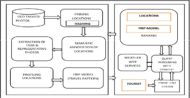
B. Geotagged photos:
The geotagged photos are collected and serves as the input for the recommendation system. The components of the recommendation system are illustrated in figure 2.The steps are as follows:
a. Finding location using hashing
The given photos have geo coordinate data. The geo-tagged photos are used and the tourist locations are identified by applying the hashing method. The locations are categorised as virtual bins of variable size. The geo-coordinates that falls inside the same virtual bin is provided with the same key (location). The key is served as an identifier with a matrix having user locations.
b. Semantic annotations
The identified geographical locations are annotated with semantic tags to describe the location. A method is provided to give semantic meanings to locations. This method uses textual tags annotated with photos which automatically generate textual descriptions (name) and category for each tourist location.
c. Profiling location
d. Trip model
From geo-tagged photos,we can extract the travel trajectories of different tourists. Therefore, trip models are introduced from them which represent canonical move sequences among tourist places.
e. Query processing
The tourists entered the queries are processed with respect to their context referring to the weather web services. After that, ranks are allocated for the tourist locations and travel sequences.
Figure 2: Components in recommendation system using geotagged photos
IV. RESULTS AND DISCUSSION
The proposed algorithm is implemented with IntelliJ. This TAST model shows the representation of the packages and tourists based on Bayesian networks, so that the similarity between packages and tourists can be measured. We formalize package generation as a What- Who-When-Where (4W) problem. W stands for the travel topics, the target tourists, the seasons, and the corresponding landscape located areas. We propose an approach on personalized travel package recommendation based on the TAST model. Specifically, we first use the output topic distributions of TAST to find the seasonal nearest neighbours for each tourist.
Collaborative filtering is used filters information by using the recommendations of other people. It is based on the idea that people who agreed in their evaluation of certain items in the past are likely to agree again in the future. A person who wants to go for a trip, might ask for recommendations from friends. The recommendations of some friends who have similar interests are trusted more than recommendations from others. This information is used in the decision on which movie to see.
In this application, we apply the so called neighbourhood-based technique. In the neighbourhood-based approach a number of users is selected based on their similarity to the active user. A prediction for the active user is made by calculating a weighted average of the ratings of the selected users.
In geotagged phase, the first step involves the collection of geo-tagged photos which serves as the input for the recommendation engine. Using the geo-tagged photos the tourist locations are identified by applying the proposed hashing technique. Here, locations are grouped as bins of variable size. The locations that are present inside each bin are annotated using a scoring algorithm using a specific tag. For these annotated locations, the corresponding photos are obtained. From the obtained information the next step involves profiling the locations. This is carried out by
i. Sorting of locations based on no. of visits and timestamps ii. Comparison of users based on locations.
iii. The trip model is generated based on the previous results.
The performance analysis of the proposed system is shown in figure3.This is the profiling done against the recommendation system using an automated script, with different loads. In each try the number of queries are incremented by 10 and obtained the time taken for each. The above graph gives the details of performance test done.
Figure 3 : Performance analysis of proposed system
V. CONCLUSION AND FUTURE WORK
The TAST model can discover the interests of the tourists and extract the spatial-temporal correlations among landscapes. Then, we used the output of TAST model i.e. topic distributions for developing a recommendation approach on personalized travel package recommendation. Then we extended the TAST model to the TRAST model, which can capture the relationships among tourists in each travel group. Also,we proposed a tourist recommendation strategy exploiting geotagged photos to find the tourist locations within a city and integrating based on the geo-tagged photos of users on social media sites. The experimental results demonstrate that the TAST model can capture the unique characteristics of the travel packages, the recommendation approach can lead to better performances of travel package recommendation, and the TRAST model can be used as an effective assessment for travel group automatic formation and the proposed approach exploiting geotagged photos are able to generate better recommendations as compared to other methods.
As for future works, in the current system images are fed manually to the system, which mimics the crawling functionality of the system. Instead of this manual feed, we need to develop features to crawl site in a defined intervals and updated the indexes to keep the recommendation system up-to-date.
REFERENCES
1. F. Ricci and Q. Nguyen,”Mobyrek: A Conversational Recommender System for On-the-Move Travelers”,Destination Recommendation
Systems: Behavioural Foundations and Applications, chapter 17, pp. 281-294,2006
2. O.Averjanova, F. Ricci, and Q.N. Nguyen,”Map-Based Interaction with a Conversational Mobile Recommender System”,Proc. Second
Int’l Conf. Mobile Ubiquitous Computing, Systems, Services and Technologies (UBICOMM ’08), pp.212-218,2008.
3. Khetarpaul, Sonia, Rashmi Chauhan, S. K. Gupta, L. Venkata Subramaniam, and Ullas Nambiar , “Mining GPS data to determine
interesting locations”, Proceedings of the 8th International Workshop on Information Integration on the Web,2011.
4. Zheng, Yu, Lizhu Zhang, Xing Xie, and Wei-Ying Ma , “Mining interesting locations and travel sequences from GPS trajectories” ,
Proceedings of the 18th international conference on World wide web, pp. 791-800,2009.
5. Sun, Yeran, Hongchao Fan, Mohamed Bakillah, and Alexander Zipf,”Road-based travel recommendation using geo-tagged images “,
Computers, Environment and Urban Systems,2013
6. Qi Liu, Enhong Chen, Senior Member, HuiXiong, Senior Member, Yong Ge, Zhongmou Li, and Xiang Wu,” A Cocktail Approach for
Travel Package Recommendation”, IEEE transactions on knowledge and data engineering, vol. 26, no. 2, pp.278-293,2014.
7. Jitha PB and Reshma M,”Literature survey on tourism recommendation”,Internationl Journal of Innovative Research in Computer and
Communication Engineering(IJIRCCE),vol.5,Issue2,2320-9801,2017.
8. Cao, Xin, Gao Cong, and Christian S. Jensen ,”Mining significant semantic locations from GPS data”, Proceedings of the VLDB
Endowment 3, pp. 1009-1020,2010.
9. Lee, Ickjai, Guochen Cai, and Kyungmi Lee,”Exploration of geo-tagged photos through data mining approaches “, Expert Systems with
10. Y. Ge et al.,”Cost-Aware Travel Tour Recommendation”, Proc. 17th ACM SIGKDD Int’l Conf. Knowledge Discovery and Data Mining
(SIGKDD ’11), pp. 983-991,2011.
11. F. Cena et al.,”Integrating Heterogeneous Adaptation Techniques to Build a Flexible and Usable Mobile Tourist Guide”, AI Comm., vol.
19, no. 4, pp. 369-384,2006.
12. Q. Liu, E. Chen, H. Xiong, C. Ding, and J. Chen,” Enhancing Collaborative Filtering by User Interests Expansion via Personalized
Ranking”, IEEE Trans. Systems, Man, and Cybernetics, Part B:Cybernetics, vol. 42, no. 1, pp. 218-233,2012.
13. S. Staab et al.,”Intelligent Systems for Tourism”,IEEE Intelligent Systems, vol. 17, no. 6, pp. 53-66,2002.
14. M. Xie, L.V.S. Lakshmanan, and P.T. Wood ,”Breaking Out of the Box of Recommendations: From Items to Packages”, Proc. Fourth
ACM Conf. Recommender Systems (RecSys ’10), pp. 151-158,2010.
15. A. Mccallum, X. Wang, and A. Corrada-Emmanuel, “Topic and Role Discovery in Social Networks with Experiments on Enron and
Academic Email”,J. Artificial Intelligence Research, vol. 30, pp. 249-272,2007.
16. M. Rosen-Zvi et al.,”The Author-Topic Model for Authors and Documents”,Proc. 20th Conf. Uncertainty in Artificial Intelligence (UAI