MANAGING 3D SPATIAL OBJECTS
Harith Fadzilah Abd Khalid
Nor Suhaibah Azri
Alias Abdul Rahman
Department of Geoinformatics,
Faculty of Geoinformation Science and Engineering,
Universiti Teknologi Malaysia, 81310 UTM Skudai, Johor, Malaysia.
ABSTRACT
through other application software such as Autodesk Map3D or Bentley MicroStation. Simple query within the SQL for the 3D objects is also possible. The paper also will highlight the future outlook of the data structuring approach for managing large volume of 3D spatial objects and relates with current research development in 3D GIS.
Keywords: Data structures, Data management, 3D spatial objects, Geo-DBMS, 3D GIS
1.0 INTRODUCTION
Since GIS was introduced, it has a vital role to maintain, manipulate, analyze and presenting information about spatial phenomena. GISs are widely used in many government, business and private activities; which fall into three major categories (Maguire et al., 1991): a) socio-economic applications (e.g. urban and regional planning, cadastrial registration, archaeology, natural resources, market analysis, etc.); b) environmental applications (e.g., forestry, fire and epidemic control, etc.); and c) management applications (e.g., organization of pipeline networks and other services, such as electricity and telephones, real-time navigation for vessels, planes and cars, etc.). The role of GISs in these applications is to provide the users and decision-makers with effective tools for solving the complex and usually ill or semi-structured spatial problems, while providing an adequate level of performance.
medium for spatial data storage, maintenance, operation and integration purposes.
Lately the availability of 3D data through digital photogrammetry and fast data acquisition such as Light Detection and Ranging (LIDAR) have made applications related to 3D information such as urban planning, telecommunication and 3D cadastre have increased (Stoter, 2004, A. Rahman et.al., 2002). Complex structures have been built, be it on the ground, under the ground or even hanging above the ground. Current 2D system to tackle 3D situation is no longer applicable. But the availability of accepting 3D coordinates for spatial objects which defined by the 2D geometric type in the DBMS made possible to describe 3D points, 3D lines and 3D polygons (Zlatanova, 2006). Managing 3D spatial object in the geo-database for a large area is challenging. This motivates us to embark in this research.
The paper is organized in the following order: first, a short discussion for the geo-database. Then, the 3D data model and the structure of the 3D object in Oracle. The experiment and some discussions presented in section four and the concluding remarks in section five.
2.0 GEO-DATABASE
objects can be executed. More and more commercial DBMSs provide spatial extensions to support spatial objects.
Most current mainstream DBMSs offer spatial data type and spatial functions similar to the OpenGIS Consortium (OGC, 1998) Simple Features Specification for SQL (OGC, 1999). The spatial data stored can be accessed by many front-end engines such as MicroStation Bentley, ArcGIS and Autodesk Map 3D. According to the OpenGIS specifications, the spatial object is represented by two structures, i.e.
geometrical (i.e. simple feature specifications) and topological (i.e. complex feature specifications). The geometric structure provides direct access to the coordinates of individual objects, while the topological structure encapsulates information about their spatial relationships. Presently, geometrical model has been implemented in mainstream DBMSs.
In other word, a full-fledged DBMS which has capabilities for handling spatial data is called Geo-database or Geo-DBMS (Gunting, 1994). A Geo-DBMS knows primitive and composed geometric data types i.e. point, line and polygon, in the same way as its primitive standard data types such as character, string, integer, real etc. The implementations of spatial data type in mainstream DBMSs are basically 2D and the spatial features are stored in a geometrical model without the internal topology. Topological relationships between geometries can be retrieved by the use of spatial operators.
3.0 3D DATA MODELS
(3DFDS) model, TEtrahedral Network (TEN) model, Simplified Spatial Model (SSM) and Urban Data Model (UDM). The 3DFDS was introduced by Molenaar (1990) consist of three fundamental levels:
feature (related to a thematic class), four elementary objects (point,
line,body and surface) and four primitives (node,arc,face and edge). It has all the necessary data to visualise the geometry of objects but in term of performance issues, it has disadvantages. The second model, TEN introduced by Pilouk (1996) as an alternative to the 3DFDS which have some difficulties in modelling objects with indiscernible boundaries. The model is appropriate for representing irregularities in the real world, such as terrain, soil, air, geological objects, etc. TEN has four constructive objects (tetrahedron, triangle, edge, node). The general rule in this model is based on the fact that each node is part of an arc, each arc is part of a triangle and each triangle is part of a tetrahedron. A body object is composed of tetrahedrons, a surface object of triangles, a line object of arcs and a point object of nodes.
The third model, Simplified Spatial Model (SSM) introduced by Zlatanova (2000). It was designed to serve web-oriented applications where spatial queries need to be visualized on the screen as 3D models. Interestingly it has four simple objects but with two primitives i.e. node and face. The faces represent the 3D object. The last model is the Urban Data Model (UDM) introduced by Coors (2003).
3.1 3D object in geo-DBMS
Based on the SSM model approach, 3D object can be stored in the database. Figure 1 shows the UML class diagram of Simplified Spatial Model (Zlatanova, 2000). The data types embedded in 3D space, i.e. point, line and polygon can be represented with their 3D coordinates. In this paper the approach used to represent the 3D objects through a set polygons (with 3D coordinates) composing the objects. This approach also has the advantage of being ‘understandable’ for all the front-ends (GIS/CAD/AEC) since it is supported by the DBMS.
Figure 1: UML class diagram of Simplified Spatial Model (Zlatanova, 2000)
In Oracle Spatial, the geometric description of a spatial object is stored in a user-defined table i.e. in a single row and in a single column of object type SDO GEOMETRY. Any tables that have a column of type SDO GEOMETRY must have another column, or set of columns, that
define a unique primary key for that table. Tables of this sort are referred to as geometry tables. Figure 2 shows the SDO GEOMETRY in Oracle Spatial 10g.
Figure 2: SDO_GEOMETRY in Oracle Spatial
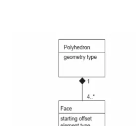
Figure 3: Polyhedron Data Structure
3.2 Spatial Indexing
indexing, any searches for a feature would require a sequential scan of every record in the database. Indexing speeds up searching by organizing the data into a search tree that could be quickly traversed to find a particular record. A R-Tree is a depth-balanced tree extending the B-tree for n-dimensions. The index stores the minimum bounding boxes as representations, not the objects themselves. It is equally referred to as a minimum bounding rectangle (MBR). There is no standard syntax/command/structure stated by OGC that enables any DBMS to be implemented. Only the DBMSs themselves provide their own syntax/command/structure that establishes the spatial index. The concept of sample R-tree structure is given in Figure 4 and Figure 5 in two and three-dimensions.
Figure 5: A 3D representation of an R-tree
Oracle Spatial, is able to provide 3D indexing for 3D object (MULTIPOLYGON). For Spatial, the metadata that maintains the lower and upper bounds and tolerance of 3D object needs to be created. Later, a spatial index (R-tree in 3D) could be created on tables to speed up spatial queries. The following example denotes the sample in creating a 3D spatial index within Spatial.
-- Inserting metadata for 3D object: MULTIPOLYGON
INSERT INTO user_sdo_geom_metadata VALUES (‘Obj3d’, ‘shape’,
mdsys.sdo_dim_array(
-- Creating 3D Spatial Index
CREATE INDEX Obj3d_I on Obj3d(shape) INDEXTYPE IS mdsys.spatial_index
PARAMETERS(‘sdo_index_dims=3’); -- Dimension = 3
ANALYZE TABLE Obj3d COMPUTE STATISTICS
4.0 EXPERIMENT
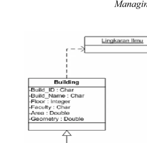
Figure 6: Shows the UML class diagram of the database
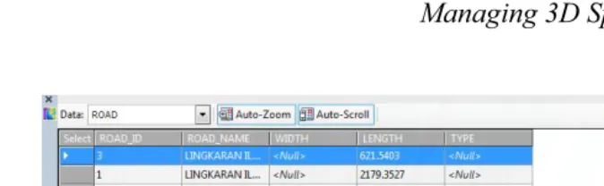
Figure 7(b): Close up 3D buildings and roads stored in the Oracle Spatial displayed in
Figure 8(b): Buildings and roads table in Oracle Spatial displayed in Autocad Map 3D
Figure 9: Simple SQL query
5.0 CONCLUDING REMARKS
visualized in 3D. Any attribute concerning the buildings can be attached to via the attribute column in the feature table. SQL query can be done based on the spatial object itself or their attribute. The real look of the buildings is also possible by applying real texture to the building (face) which will be part of this research in the near future.
REFERENCES
Bruenig, M and Zlatanova, S. (2004). 3D-GeoDBMS, Directions Magazine
Coors, V, (2003). 3D-GIS in networking environments, In Computers, Environment and Urban Systems, Pergamon. Pp345-357.
Güting, R.H, (1994). An Introduction to Spatial Database Systems. VLDB Journal Vol. 3 no. 4, pp357-399
Maguire, David J., Goodchild, M.F, Rhind, D.W (1991).
Geographical Information Systems: Principles and applications.
Longman Group UK
Molenaar, M., (1990). A formal data structure for 3D vector maps, in: Proceedings of EGIS’90, Vol. 2, Amsterdam, The Netherlands, pp. 770-781
OGC (1998). The OpenGIS Guide, Third edition. An introduction to Interoperable Geo-processing. The OGC Project Technical Committee of OpenGIS Consortium, edited by Buhler and K. McKee, L., Wayland, Mass., USA
OGC (1999). OpenGIS Simple Features Specification for SQL. Revision 1.1, OpenGIS Project Document 99-049
Rahman, A.A, Zlatanova, S., Pilouk M., (2002). Trends in 3D GIS Development. In Journal of Geospatial Engineering, Vol.2, No.2 pp. 1-10.
Stoter, J. (2004). 3D Cadastre. PhD. Thesis. TU Delft/ Netherlands Zlatanova, S. (2006). 3D Goemetries in Spatial DBMS.
3DGeoinfor’06 International Workshop on 3D Geoinformation, Kuala Lumpur
Zlatanova, S. (2000). 3D GIS For Urban Development. PhD Thesis. University of Graz, Austria.