ABSTRACT
HUNTER III, JOSEPH EARL. Integration of Unmanned Aerial Vehicles (UAVs) for Remote-Sensing and Spray Applications for Weed Management. (Under the direction of Dr. Ramon Leon).
The common characteristic of weeds of having patchy spatial distributions provides the opportunity for site-specific management. Site-specific weed management has been proven to be a viable alternative to reduce broadcast weed control and consequently decreasing herbicide usage and improving environmental quality. Unmanned aerial vehicles (UAVs) offer a new management platform that can account for spatial variability in weed populations to conduct site-specific management. UAVs can be used to collect imagery for monitoring and decision-making purposes as well as to conduct aerial pesticide applications. In recent times, UAVs have become commercially available for both agricultural implications. Limited research has been conducted concerning aerial pesticide applications from UAVs. Two independent field studies were
conducted to evaluate the feasibility of integrating UAVs for weed mapping and spraying (UAV-IS) and to optimize UAV application parameters and assess the influence of nozzle type on the potential for off-target movement.
In the first study, field experiments were conducted to characterize the effect of 1, 3, 5, and 7 m s-1 application speeds using extended range flat spray, air induction flat spray, and turbo air induction flat spray nozzles on spray coverage and uniformity of UAV applications.
decreased as application speed increased across all nozzles. Off-target movement was observed under all perpendicular wind conditions across all nozzles but was non-detectable over 5 m from the target. Coverage from all nozzles exhibited a concave shaped curve in response to
perpendicular wind speed due to turbulence. The highest achieved coverages in the drift studies were under both 0 and 8.94 m s-1 perpendicular wind conditions, but higher turbulence at the two highest perpendicular wind speeds (6.71 and 8.94 m s-1,) increased coverage variability while the lowest variability was observed at 2.24 m s-1.
In the second study, glufosinate was applied at a rate of 594 g ai ha-1 in 151 L ha-1 and 187 L ha-1 for UAV and ground-based broadcast treatments in four experiments over two
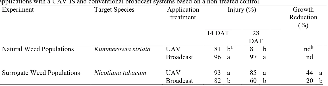
locations. Locations differed in weed population coverage, which affected application efficiency and efficacy. The UAV system was up to 200% more efficient at identifying and treating weedy areas, while minimizing treatment on non-weedy areas, than the broadcast application. The UAV system treated 20-60% less area per experimental unit than ground-based broadcast applications, but also missed up 26% of the weedy area, while broadcast applications covering almost the entire experimental unit only missed 2-3%. The benefit of the UAV-IS avoiding unnecessary application of non-weedy areas compensated for the small portion of weeds that were missed, while the advantage of the broadcast application of treating all weedy areas was minimized by the wasteful amount of herbicide that was applied to weed-free areas. Visual estimates of weed control showed UAV treatments were 12% and 25% higher than broadcast treatments at 14 and 28 DAT when treating highly aggregated weed populations, but 15% lower at both 14 and 28 DAT when treating higher populations with a more uniform distribution.
Integration of Unmanned Aerial Vehicles (UAVs) forRemote-Sensing and Spray Applications for Weed Management
by
Joseph E Hunter III
A thesis submitted to the Graduate Faculty of North Carolina State University
in partial fulfillment of the requirements for the degree of
Master of Science
Crop Science
Raleigh, North Carolina 2019
APPROVED BY:
_______________________________ _______________________________ Dr. Ramon G. Leon Dr. Robert J. Richardson
Committee Chair
ii DEDICATION
This thesis is dedicated to the memory of my grandpa James “Pa” Jarman. Thank you for
iii BIOGRAPHY
Joseph E. Hunter III was born and grew up in Kinston, North Carolina where he spawned a love for agriculture. While in high school he gained work experience on his grandfather’s row
iv TABLE OF CONTENTS
LIST OF TABLES ... v
LIST OF FIGURES ... vi
Literature Review ... 1
Weed Problems and Management ... 1
Spray Applications and Drift ... 3
Precision Agriculture and Unmanned Aerial Vehicles ... 6
References ... 14
Chapter 1: Coverage and Drift Potential Associated with Nozzle and Speed Selection for Herbicide Applications using an Unmanned Aerial Sprayer ... 22
Introduction ... 24
Materials and Methods ... 27
Application Speed and Nozzle Type ... 28
Perpendicular Wind Conditions and Nozzle Type ... 29
Results and Discussion ... 30
Application Speed and Nozzle Type ... 31
Perpendicular Wind Conditions and Nozzle Type ... 32
References ... 35
Chapter 2: Integration of Remote-Weed Mapping and an Autonomous Spraying Unmanned Aerial Vehicle for Site-Specific Weed Management ... 43
Introduction ... 45
Materials and Methods ... 47
Natural Weed Population ... 48
Surrogate Weed Population ... 49
Data Analysis ... 50
Results and Discussion ... 51
Natural Weed Population ... 51
Surrogate Weed Population ... 52
References ... 56
Chapter 3: General Conclusions and Recommendations for Future Research ... 69
Research Conclusions ... 69
General Conclusions ... 70
v LIST OF TABLES
CHAPTER 2
Table 1. Injury at 14 and 28 days after treatment (DAT) and dry weight growth reduction for target species after glufosinate applications with a UAV-IS and
vi LIST OF FIGURES
CHAPTER 1
Figure 1. Target area coverage resulting from UAV applications with fine (XR), coarse (AIXR), and ultra-coarse (TTI) nozzles at increasing application speeds at a fixed application output per time unit (680 ml min-1 per nozzle). Application speeds of 1, 3, 5, and 7 m s-1 were equivalent to application volumes of 151, 50, 30, and 22 L ha-1, respectively. Values are averaged over repeated study
and 4 replications for each. Error bars represent 95% CI ... 39 Figure 2. Spray coverage for AIXR, XR, HC and TTI nozzles influenced by
perpendicular wind speed at different distances downwind from the target area. X axis represents distance downwind from target area (m), Y axis represents perpendicular wind speed (m s-1) over target area, and Z axis represents coverage (%). Values are averages of two experimental runs with
3 replications for each ... 40 Figure 3. Box plots comparing spray coverage at 0, 2.5, and 5 m from the target area
depending on perpendicular wind speed (m s-1). Values are combined over four nozzle types, and two experimental runs with 3 replications. Error bars
represent 5th and 95th percentiles ... 41 Figure 4. Influence of perpendicular wind speed (m s-1) on spray coverage on target
area. Values are pooled over four nozzle types, and two experimental runs with 3 replications each. Error bars represent 5th and 95th percentiles. Values above each perpendicular wind speed box represent the coefficient of
variation (%) ... 42 CHAPTER 2
Figure 1. Supervised image classification was conducted to identify weeds by color differences (a-b). After identifying target areas, GPS coordinates associated with the collected imagery were extracted to create paths of travel for site specific UAV applications (c). UAV data collecting flight missions were conducted to create a new map for post-application analysis (d-e). Overlaying plot boundary (a), weed detection (b), and spray analysis (e) maps allowed quantifying on-target and off-target treated areas to later
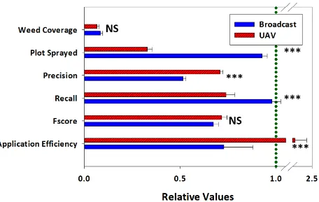
vii Figure 2. Relative estimates of application indexes for UAV-IS and conventional
broadcast treatments of glufosinate in a sod field with natural populations of Kummerowia striata in Willow Springs, NC. The dotted line indicates a relative value of 1.0 for each index and is equivalent to the entirety of the experimental unit for weed coverage and plot sprayed. Asterisks represent statistical significance (NS: Non-significant; *, **, *** indicated statistical
differences at 0.05, 0.01, and 0.001 significance levels, respectively) ... 67 Figure 3. Relative estimates of application indexes for UAV-IS and conventional
broadcast treatments of glufosinate in a sod field with surrogate weed populations generated wit Nicotiana tabacum plants in Eagle Springs, NC. The dotted line indicates a relative value of 1.0 for each index and is
equivalent to the entirety of the experimental unit for weed coverage and plot sprayed. Asterisks represent statistical significance (NS: Non-significant; *, **, *** indicated statistical differences at 0.05, 0.01, and 0.001 significance
1 Literature Review
Weed Problems and Management
The Weed Science Society of America (WSSA) defines a weed as “any plant that is objectionable or interferes with the activities or welfare of man (Anonymous 2002)”. Weeds
compete against crops, reducing both crop yield and quality (Smith et al. 2009) resulting in significant economic damage (Moss 2019) and must be controlled for successful crop production (Gianessi 2013). The goal of weed management is to “optimize crop production and growers’ profits through preventive tactics, scientific knowledge, management skills, and the use of weed control practices” (Buhler et al. 2000). Weed management must focus on the causes of weed problems and solutions based on integrating new techniques and knowledge (Buhler et al. 2000).
The standard practice to limit crop-weed competition has been to remove emerged weeds or prevent weed emergence (Smith et al. 2009). A wide array of challenges are associated with weed management practices, including selecting appropriate control tactics, timing of
implementation, containing accumulating costs through the season, and minimizing seed production (Buhler et al. 2000). It is apparent no single weed management strategy can provide acceptable weed control on its own (Swanton and Weise 1991). Therefore, combining multiple weed control practices can be beneficial to ensure stable and consistent weed control over time.
Herbicides and tillage are the dominant and most effective forms of weed control across many production systems (Buhler et al. 2000). However, herbicides as chemical weed
management are the main tool used for modern weed management (Harker and O’Donovan 2013; Heap 2014; Manalil et al. 2011; Metcalfe et al. 2018). Herbicides are highly effective weed control tools (Harker and O’Donovan 2013; Heap 2014) that are cost and time efficient
2 the introduction of inorganic copper salts to control emerged weeds (Hamill et al. 2004). 2,4-dichlorophenoxyacetic acid was developed in 1942 as the first selective herbicide (Oerke 2006), and more recently crops have been engineered to tolerate herbicides to which they are naturally susceptible. Genetically modified (GM) crops tolerant to herbicides were released in 1996 (Brookes 2014). These transgenic crops were tolerant to glyphosate, a non-selective herbicide used for broad spectrum emerged weed control, to be used during the growing season to control weeds without causing crop damage (Powles 2008). Since their initial release, GM crops have been rapidly adopted by farmers (Brookes 2014; Owen 2008). GM crops improved
environmental benefits by decreasing the total amount of herbicide being used, allowing the adoption of soil conservation practices such as reduced- and no-tillage (Brookes 2014). The ease and convenience associated with GM crops and glyphosate had the unintended consequence of decreasing the diversification of weed management practices (Hamill et al. 2004; Powles 2008; Shaner and Beckie 2014) and has led to the usage of herbicides becoming the primary form of weed control (DeVore et al. 2012).
The use of herbicides as weed control is growing worldwide (Gianessi 2013), including in developing countries (Walsh et al. 2012), because they decrease the need for hand labor for weeding (Hamill et al. 2004; Oerke 2006) and improve the efficiency of mechanical harvest of crops (Oerke 2006). Worldwide industrialization has created hand labor shortages, driving chemical weed management adoption (Gianessi 2013). The worldwide adoption of herbicides for crop production has greatly influenced weed science research (Wyse 1992), centering it around herbicide efficacy and environmental fate (Davis et al. 2009).
Herbicides have greatly improved weed control and contributed significantly to
3 decreasing the need for crop rotation (Buhler et al. 2000; Gianessi 2013; Hamill et al. 2004). The development of postemergence herbicides favored adoption of reduced-tillage systems (Buhler et al. 2000; Hamill et al. 2004; Somerville et al. 2017), where tillage had once been the primary form of weed control (DeVore et al. 2012). Cultivating crops for weed control requires more energy than applying herbicides (Gianessi 2013). Intensive tillage can lead to
environmental issues such as soil erosion and pesticide run-off (DeVore et al. 2012). Due to these issues, tillage as a main weed control practice is considered an unsustainable practice and has decreased worldwide for weed control (Gianessi 2013). Reduced and no-till systems as alternative practices decreasing soil erosion and water pollution (Hamill et al. 2004) have been deemed more sustainable (DeVore et al. 2012).
Spray Applications and Drift
Spraying pesticides comprises the release of the chemical solution to the intended target, landing and retention of spray on the target, and its leaching, volatilization, and decay of spray residues (Combellack 1982). Proper spray coverage is very important for all spray applications, especially POST applied herbicides (Sharpe et al. 2017). The most challenging problem
4 The extent of spray drift is influenced by a variety of meteorological factors including wind speed, atmospheric stability, turbulence, and temperature, and application factors such as sprayer type, nozzle type, nozzle size, nozzle pressure, application height, application speed, and nozzle angle (Carlsen et al. 2006). Properties of the spray formulation influenced by additives, density, and viscosity of the spray may also create an impact on spray drift (Carlsen et al. 2006). Wind speed is the most important meteorological factor for spray drift (Bode et al. 1976). Grover et al. (1997) documented consistent decreases in spray coverage over the target area as wind speed was increased. Furthermore, increases in application height and spray pressure both correlate with increases in spray drift (Frank and Ripley 1994). Bode et al. (1976) found
application height to be the single most significant factor on spray drift, to which wind speed was second to. For these reasons, the accuracy and safety of any spraying equipment must be
evaluated considering application height and wind conditions.
The physical properties of the spray solution are major contributors to spray drift (Miller and Butler Ellis 2000). The droplet spectra and droplet size are influenced by wind speed, boom height, spray pressure, and nozzle selection and in turn, contributes to spray drift (Combellack 1982). The spectra of droplet size distribution not only influence spray drift, but also spray deposition, coverage, and application efficacy (Bouse et al. 1990). The possibility of spray drift can be decreased by controlling the spray droplet spectra and droplet size (Legleiter and Johnson 2016). Preventing the formation of very small droplets (<100 µm in diameter) can allow for reductions in spray drift (Frank et al. 1991).
5 designed to reduce drift when being compared to standard flat fan nozzles (Wolf 2005). Flat fan nozzles produce smaller droplets that are more prone to drift than air inducted drift nozzles (Legleiter and Johnson 2016). While smaller spray droplets increase the risk of spray drift, they can be desirable to improve herbicide efficacy by increasing the weed tissue covered with the spray solution (Knoche 1994). Standard flat fan nozzles are discouraged from being used by applicators under high wind conditions due to the potential of spray drift (Johnson et al. 2006). Anti-drift nozzles are designed to reduce the production of small, drift-prone spray droplets and replace them with much larger spray droplets (Derksen et al. 1999; Grover et al. 1997). The larger droplets are created by adding a pre-orifice to the nozzle tip before the nozzle orifice (Derksen et al. 1999). Adjuvants are also commonly added to the tank mix of spray solution to adjust the spray characteristics to exhibit desirable traits (Johnson et al. 2006). The additional costs of using drift controlling adjuvants makes them a more expensive option than the use of drift-reducing nozzles (Johnson et al. 2006). Adjuvants do not increase herbicide efficacy but can assist with preventing drift when paired with proper spray nozzles (Johnson et al. 2006).
6 expensive, and difficult to use since the spray output cannot be observed through the shields (Wolf et al. 1993). Hooded sprayers also increase the variability in spray coverage beneath the hood and allows the spray to be susceptible to drift under high wind conditions (Wolf et al. 1993).
Precision Agriculture and Unmanned Aerial Vehicles
The concept of precision agriculture is not new. In fact, it is a very old technique still being conducted in its raw form today by subsistence farmers dividing their already small land partitions into even smaller units to grow and manage crops at an increased level of precision to maximize their yields (Oliver 2010). The modern version of precision agriculture can be defined as “a management strategy that uses information technologies to bring data from multiple
sources to bear on decisions associated with crop production (National Research Council 1997).” Modern precision agriculture began during the 1980s to reduce fertilizer inputs and improve fertilizer allocation within fields (Oliver 2010; Zhang et al. 2002). Before then, the increase of mechanization had driven farm management to large scale uniform operations (Oliver 2010). Management units had become field size, increasing the amount of variability within them (Oliver 2010). Massey Ferguson released the first yield meter in 1982, providing real-time yield measurements that could be pinpointed in the field (Oliver 2010). Searcy et al. (1989)
7 pest infestations (Lee et al. 2010). Mulla (1993) split a wheat field into three separate fertility zones prescribing reduced rates compared to the conventional broadcast rate and found no
significant differences in grain yield, but did observe differences in organic matter, soil moisture, residual nitrogen, and potential grain yield between fertility zones. Carr et al. (1991) correlated potential yield goals with soil types requiring different fertilizer rates and found consistent increases in profitability by applying fertilizer by soil type rather than field broadcast. Precision agriculture and can increase farm profitability through a more efficient management of farm inputs (Zhang et al. 2002) and also improves environmental quality (Mulla 1993). Precision agriculture provides the opportunity to change the distribution and timing of fertilizer and other agrochemical inputs based on spatial and temporal variability within field (Zhang et al. 2002). This lowers the risk and decreases the uncertainty associated with making management decisions (Schellberg et al. 2008).
The goals of aerial pesticide applications as an alternative to ground-based applications are to be cost-effective, efficient, and environmentally safe (Huang et al. 2017). Airplane based applications pose the highest risk for off-target spray drift among all agricultural spray
8 generally prohibit aerial pesticide applications under very stable atmospheric and wind
conditions to avoid air temperature inversions (Bird et al. 1992).
Unmanned aerial vehicles (UAVs) were developed for military use, but the rapid widespread of efficient technologies for batteries, global positioning systems (GPS), and computers accessible to civilians have increased the potential of UAVs for other purposes
(Ehsani and Maja 2013; Hogan et al. 2017). The high versatility of UAV platforms makes them a viable alternative to manned aircraft for aerial pesticide applications (Wang et al. 2018; Xinyu et al. 2014; Ying et al. 2016). UAVs can conduct aerial applications at lower heights than manned aircraft and do not require a runway to take off or land (Xinyu et al. 2014). Their flight
parameters make them suitable for areas of limited access for personal or conventional spray equipment (Wang et al. 2018). Per scale, UAVs consume less power than any alternative agricultural pesticide machinery (Ying et al. 2016). Physically removing the pilot from the aircraft lowers the safety risk associated with aerial pesticide applications (Wang et al. 2018). The light weight design and associated lower costs for UAVs over manned aerial spray equipment has further increased their potential for aerial applications (Xinyu et al. 2014).
9 et al. 2018). Therefore, there is a need to properly characterize spray parameters for aerial
pesticide application from UAVs, so regulators can and industry can develop the necessary recommendations to optimize effective pest control and minimize off-target movement (Wang et al. 2018, Yang et al. 2018).
The main limitation for UAV sprayers is battery and electric motor technology
restraining the flight times and payload capacities of UAVs per flight, restricting their use and overall efficiency (Ying et al. 2016). Wang et al. (2017) tested four different commercially available UAV sprayers and found the daily working capacity of 13.4-18 ha2 unsatisfactory for broadcast spray applications.
Precision agriculture is comprised of three main activities: data acquisition, data interpretation, and management response or action (Oliver 2010). Piloted aircraft and satellites have been primary platforms for obtaining remotely sensed imagery for data acquisition (Torres-Sanchez et al. 2013). Airborne imagery collected from aircraft and satellites allow for soil and vegetation pattern mapping of fields without the inconsistencies associated with data collected from harvest yield monitors or soil sampling (Dobermann et al. 2004). Managing spatial and temporal variability associated with agricultural production is the driving principle for precision agriculture (Basso et al. 2017). Even though precision agriculture technologies were originally intended to increase profits, the objectives have now changed to achieve sustainable profits while reducing environmental impacts (Dobermann et al. 2004). The agricultural industry has
10 Precision agriculture has a broad range of applications for agriculture management
(Dobermann et al. 2004). The incorporation of agriculture sensors in precision agriculture allow for varying outputs, efficiency improvements, input cost reductions, reduced labor costs,
improved worker safety, lower environmental impact, autonomous field navigation, crop monitoring, and pest monitoring (Lee et al. 2010). Rapid technology development through the 1990s significantly improved GPS guidance systems (Dobermann et al. 2004). The utilization of GPS for agricultural vehicle guidance has been a driving force for precision agriculture
development, because it can increase the precision of different field practices (Dobermann et al. 2004). Chattha et al. (2014) successfully developed a tractor-based variable rate fertilizer spreader system with real time sensors to improve fertilizer allocation. Modern agricultural reflectance sensors can collect measurements of crops and weeds during the season without destroying them as was done with older methods (Felton et al. 2002). The accumulation of biomass is a proven direct measurement function of crop yield (Donald 1998), and numerous studies have successfully linked spatial variation to crop canopy reflectance, crop biomass, leaf area index, and crop yield (Dobermann et al. 2004). By using different vegetation traits that can be remotely and automatically measured with sensors, it is possible to implement corrective actions in space and time to maximize yield.
site-11 specific chemical spraying (Hong et al. 2012; Tian 2002) avoiding treating weed-free areas as currently done with broadcast applications. Smart-spraying systems are comprised of two
separate steps: detection and application (Shaner and Beckie 2014). When separate, each step has the potential for errors. By combining the two separate systems, their errors may nullify one another or increase the potential for misapplications. A smart-spraying system using spatially accurate weed mapping will increase application efficiency and minimize environmental impact (Tian 2002).
Temporal variations in weed populations are as important as spatial variations for
agricultural management (Dobermann et al. 2004), so weed detection and mapping must be done at the right time. However, ground-based sensors depend on adequate soil moisture conditions and the absence of barriers for movement across the field and landscape. Issues with obtaining adequate remotely sensed data are overcome with UAVs (Torres-Sanchez et al. 2013). UAVs offer a low-cost remote sensing platform capable of achieving desired spatial and temporal resolutions (Lopez-Granados 2011) even when conditions are limiting for ground-based sensors. UAVs with attached cameras are commercially available in the marketplace (Sugiura et al. 2016). The resolution of images collected with UAV based remote sensors is considerably higher than the one of images from satellites and airplanes (Singh and Frazier 2018). UAVs can
12 UAVs to obtain data over large areas in short amounts of time allows for more detailed planning for the design and implementation of the best management strategies compared with real-time ground-based sensors that depend on predetermined herbicide treatments (Rasmussen et al. 2013; Shaner and Beckie 2014).
Current UAV technology is comprised of a multitude of sensors, configurations, and obtainable data resolutions (Dobermann et al. 2004). The newest UAVs are capable of carrying multiple sensors at once (Maes and Steppe 2019), which can enable and simplify the
simultaneous collection of multiple measurements (Singh and Frazier 2018). UAVs can be fitted with red, blue, and green (RBG), multispectral, hyperspectral, or thermal cameras (Ehsani and Maja 2013; Maes and Steppe 2019). Thermal cameras attached to UAVs have been used to detect drought stress (Maes and Steppe 2019). The use of hyperspectral cameras has been
severely limited due to their high cost, while multispectral cameras have difficulty distinguishing weed seedlings (Lopez-Granados 2011). RBG cameras attached to UAVs can capture slightly finer resolution than multispectral cameras (Lopez-Granados et al. 2016) and have been used to phenotype crop differences (Sugiura et al. 2016).
14 REFERENCES
Anonymous (2002) Herbicide Handbook. 8th ed. Lawrence, KS. Weed Science Society of America. 462 p.
Basso B, Dobrowolski J, McKay C (2017) From the dust bowl to drones to big data: the next revolution in agriculture. Georgetown J Intern Affairs 18(3):158-165
Bird SL, Esterly DM, Perry SG (1996) Off-target deposition of pesticides from agricultural aerial spray applications. J Environ Qual 25(5):1095-1104
Bode LE, Butler BJ, Goering CE (1976) Spray drift and recovery as affected by spray thickener, nozzle type, and nozzle pressure. Trans ASAE 19:213-218
Bouse LF, Kirk IW, Bode LE (1990) Effect of spray mixture on droplet size. Trans ASAE 33:783-788
Brookes G (2014) Weed control changes and genetically modified herbicide tolerant crops in the USA 1996-2012. GM Crops & Food 5(4):321-332
Buhler DD, Liebman M, Obrychi JJ (2000) Theoretical and practical challenges to an IPM approach to weed management. Weed Sci 48(3):274-280
Carlsen SCK, Spliid NH, Svensmark B (2006) Drift of 10 herbicides after tractor spray application. 2. Primary drift (droplet drift). Chemosphere 64:778-786
Carr PM, Carlson GR, Jacobsen JS, Nielsen GA, Skogley EO (1991) Farming soils, not fields: A strategy for increasing fertilizer profitability. J Prod Agric 4(1)57-61
Chattha HS, Zaman QU, Chang YK, Read S, Schumann AW, Brewster GR, Farooque AA (2014) Variable rate spreader for real-time spot-application of granular fertilizer in wild blueberry. Comp and Elect in Agric 100:70-78
15 Combellack JH, Western NM, Richardson RG (1996) A comparison of the drift potential of a
novel twin fluid nozzle with conventional low volume flat fan nozzles when using a range of adjuvants. Crop Prot 15:147-152
Davis AS, Hall JC, Jasieniuk M, Locke MA, Luschei EC, Mortensen DA, Riechers DE, Smith RG, Sterling TM, Westwood JH (2009) Weed science research and funding: a call to action. Weed Sci 57:442-448
Derksen RC, Ozkan HE, Fox RD, Brazee RD (1999) Droplet spectra and wind tunnel evaluation of venturi and pre-orifice nozzles. Trans ASAE 42:1573-1580
DeVore JD, Norsworthy JK, Brye KR (2012) Influence of deep tillage and a rye cover crop on glyphosate-resistant palmer amaranth (Amaranthus palmeri) emergence in cotton. Weed Technol 26:832-838
Dobermann A, Blackmore S, Cook SE, Adamchuk VI (2004) Precision farming: challenges and future directions. Proc 4th Intern Crop Sci Congress: Paper
Donald WW (1998) Estimated soybean (Glycine max) yield loss from herbicide damage using ground cover or rated stunting. Weed Sci 46:454-458
Ehsani R, Maja JM (2013) The rise of small UAVs in precision agriculture. Resource Magazine July/Aug:18-19
Frank R, Johnson K, Braun HE, Halliday CG, Harvey J (1991) Monitoring air, soil, stream and fish for aerial drift of permethrin. Eviron Monit Assess 16:137-150
Felton WL, Alston CL, Haigh BM, Nash PG, Wicks GA, Hanson GE (2002) Using reflectance sensors in agronomy and weed science. Weed Technol 16:520-527
16 Fritz BK, Hoffmann WC, Bagley WE, Hewitt A (2011) Field scale evaluation of spray drift
reduction technologies from ground and aerial application systems. J ASTM Intern 8(5):1-10 Gianessi LP (2013) The increasing importance of herbicides in worldwide crop production. Pest
Manag Sci 69:1099-1105
Giles DK, Slaughter DC (1997) Precision band spraying with machine-vision guidance and adjustable yaw nozzles. Trans ASAE 40:29-36
Goering CE, Butler BJ (1975) Paired Field Studies of Herbicide Drift. Trans ASAE 18:27-34 Grover R, Maybank J, Caldwell BC, Wolf TM (1997) Airborne off-target losses and deposition
characteristics from a self-propelled, high speed, and high clearance ground sprayer. Can J Plant Sci 77:493-500
Hamill AS, Holt JS, Mallory-Smith CA (2004) Contributions of weed science to weed control and management. Weed Technol 18:1563-1565
Harker KN, O’Donovan JT (2013) Recent weed control, weed management, and integrated weed management. Weed Technol 27(1):1-11
Heap I (2014) Global perspective of herbicide-resistant weeds. Pest Manag Sci 70:1306-1315 Hogan SD, Kelly M, Stark B, Chen YQ (2017) Unmanned aerial systems for agriculture and
natural resources. Cal Agric 71:5-14
Hong S, Minzan L, Zhang Q (2012) Detection system of smart sprayers: status, challenges, and perspectives. Int J Agric and Biol Eng 5:10-23
17 Johnson AK, Roeth FW, Martin AR, Klein RN (2006) Glyphosate spray drift management with
drift-reducing nozzles and adjuvants. Weed Technol 20:893-897
Knoche M (1994) Effect of droplet size and carrier volume on performance of foliage-applied herbicides. Crop Prot 13:163-178
Lee WS, Alchanatis V, Yang C, Hirafuji M, Moshou D, Li C (2010) Sensing technologies for precision specialty crop production. Comp Electron Agric 74:2-33
Legleiter TR, Johnson WG (2016) Herbicide coverage in narrow row soybean as influenced by spray nozzle design and carrier volume. Crop Prot 83:1-8
Lopez-Granados F (2011) Weed detection for site-specific weed management: mapping and real-time approaches. Weed Res 51:1-11
Lopez-Granados F, Torres-Sanchez J, Serrano-Perez A, de Castro AI, Mesas-Carrascosa FJ, Pena JM (2016) Early season weed mapping in sunflower using UAV technology: variability of herbicide treatment maps against weed thresholds. Precision Agric 17:183-199
Maes WH, Steppe K (2019) Perspectives for remote sensing with unmanned aerial vehicles in precision agriculture. Trends Plant Sci 24:152-164
Manalil S, Busi R, Renton M, Powles SB (2011) Rapid evolution of herbicide resistance by low herbicide dosages. Weed Sci 59:210-217
Metcalfe H, Milne AE, Hull R, Murdoch AJ, Storkey J (2018) The implications of spatially variable pre-emergence herbicide efficacy for weed management. Pest Manag Sci 74:755-765
18 Moss S (2019) Integrated weed management (IWM): why are farmers reluctant to adopt
non-chemical alternatives to herbicides? Pest Manag Sci 75:1205-1211
Mulla DJ (1993) Mapping and managing spatial patterns in soil fertility and crop yield. Soil Specific Crop Management 15-26
Mulla DJ (1997) Geostatistics, remote sensing and precision farming. 1997 Precision agriculture: spatial and temporal variability of environmental quality 100-119
National Research Council (1997) Precision agriculture in the 21st century. National Academy Press 17
Oerke EC (2006) Crop losses to pests. J Agric Sci 144:31-43
Oliver MA (2010) Geostatistical Applications for Precision Agriculture. 1st ed. Dordrecht, Netherlands. Springer. Pp. 1-34
Owen MDK (2008) Weed species shifts in glyphosate-resistant crops. Pest Manag Sci 64:377-387
Peteinatos GG, Weis M, Andujar D, Ayala VR, Gerhards R (2014) Potential use of ground-based sensor technologies for weed detection. Pest Manag Sci 70:190-199
Powles SB (2008) Evolved glyphosate-resistant weeds around the world: lessons to be learnt. Pest Manag Sci 64:360-365
Primicerio J, Di Gennaro SF, Fiorillo E, Genesio L, Lugato E, Matese A, Vaccari FP (2012) A flexible unmanned aerial vehicle for precision agriculture. Precision Agric 13:517-523 Rasmussen J, Nielsen J, Garcia-Ruiz F, Christensen S, Streibig JC (2013) Potential uses of small
unmanned aircraft systems (UAS) in weed research. Europ Weed Res 53:242-248
19 Searcy SW, Schueller JK, Bae YH, Borgelt SC, Stout BA (1989) Mapping of spatially variable
yield during grain combining. Trans ASABE 32(3):826-829
Schellberg J, Hill MJ, Gerhards R, Rothmund M, Braun M (2008) Precision agriculture on grassland: applications, perspectives and constraints. Europ J Agron 29:59-71
Shaner DL, Beckie HJ (2014) The future for weed control and technology. Pest Manag Sci 70:1329-1339
Sharpe SM, Boyd NS, Ditmar PJ, MacDonald GE, Darnell RL, Ferrell JA (2017) Spray penetration into a strawberry canopy as affected by canopy structure, nozzle type, and application volume. Weed Technol 32:80-84
Singh KK, Frazier AE (2018) A meta-analysis and review of unmanned aircraft system (UAS) imagery for terrestrial applications. Int J Remote Sensing 39:5078-5098
Smith RG, Mortensen DA, Ryan MR (2009) A new hypothesis for the functional role of diversity in mediating resource pools and weed-crop competition in agroecosystems. Weed Res 50:37-48
Somerville GJ, Powles SB, Walsh MJ, Renton M (2017) Why was resistance to shorter-acting pre-emergence herbicides slower to evolve? Pest Manag Sci 73:844-851
Sugiura R, Tsuda S, Tamiya S, Itoh A, Nishiwaki K, Murakami N, Shibuya Y, Hirafuji M, Nuske S (2016) Field phenotyping system for the assessment of potato late blight resistance using RGB imagery from an unmanned aerial vehicle. Biosystems Eng 148:1-10
Swanton CJ, Weise SF (1991) Integrated weed management: the rationale and approach. Weed Technol 5:657-663
20 Tian L (2002) Development of a sensor-based precision herbicide application system. Comp and
Elect Agric 36:133-149
Torres-Sanchez J, Lopez-Granados F, De Castro AI, Pena-Barragan JM (2013) Configuration and specifications of an unmanned aerial vehicle (UAV) for early site-specific weed management. Plos One 8(3):1-15
Walsh MJ, Harrington RB, Powles SB (2012) Harrington seed destructor: a new nonchemical weed control tool for global grain crops. Crop Sci 52:1343-1347
Wang S, Song J, He X, Song L, Wang X, Wang C, Wang Z, Ling Y (2017) Performances evaluation of four typical unmanned aerial vehicles used for pesticide application in China. Int J Agric and Biol Eng 10(4):22-31
Wang C, He X, Wang X, Wang Z, Wang S, Li L, Bonds J, Herbst A, Wang Z (2018) Testing method and distribution characteristics of spatial pesticide spraying deposition quality balance for unmanned aerial vehicles. Int J Agric and Biol Eng 11(2):18-26
Wolf RE (2005) Comparing downwind spray droplet deposits of four flat-fan nozzle types measured in a wind tunnel and analyzed using dropletscan software. Trans ASAE 21:173-177
Wolf TM, Grover R, Wallace K, Shewchuk SR, Maybank J (1993) Effect of protective shields on drift and deposition characteristics of field sprayers. Can J Plant Sci 73:1261-1273 Wyse DL (1992) Future of weed science research. Weed Technol 6(1):162-165
Xinyu X, Kang T, Weicai Q, Lan Yubin, Zhang H (2014) Drift and deposition of ultra-low altitude and low volume application in paddy field. Int J Agric and Biol Eng 7(4):23-28 Yang S, Yang X, Mo J (2018) The application of unmanned aircraft systems to plant protection
21 Ying Z, Xiuyan G, Zhiyan Z, Xiwen L, Yu Z, Xingyuan Q, Wulan L, Cheng Y (2016) Review of
tensairity and its applications in agricultural aviation. Int J Agric and Biol Eng 9(3):1-14 Zhang N, Wang M, Wang N (2002) Precision agriculture—a worldwide overview. Comp
22 CHAPTER 1: Coverage and Drift Potential Associated with Nozzle and Speed Selection for
Herbicide Applications using an Unmanned Aerial Sprayer Article to be submitted for publication to Weed Technology
In recent years, unmanned aerial vehicle (UAV) technology has expanded to include UAV sprayers capable of applying pesticides. Very little research has been conducted optimizing application parameters and measuring the potential of off-target movement from UAV-based pesticide applications. Field experiments were conducted in Raleigh, NC during the spring of 2018 to characterize the effect of 1, 3, 5, and 7 m s-1 application speeds (i.e. equivalent to 151, 50, 30, and 22 L ha-1) and extended range flat spray, air induction flat spray, and turbo air induction flat spray nozzles on target area coverage and uniformity of UAV applications. Experiments measuring the drift potential of UAV applications using extended range flat spray, air induction flat spray, turbo air induction flat spray, and hollow cone nozzles under 0, 2.24, 4.47, 6.71, and 8.94 m s-1 perpendicular wind conditions in the immediate 1.75 m above the target were conducted outdoors in the absence of natural wind in Raleigh, NC. The highest coverage was achieved with an application speed of 1 m s-1 and ranged from 30 to 60%, while applications at 7 m s-1 yielded 13 to 22% coverage. Coverage consistently decreased as
application speed increased across all nozzles, with extended range flat spray nozzles declining at a faster rate than air induction nozzles likely due to higher drift. Off-target movement was observed under all perpendicular wind conditions with all nozzles tested but was non-detectable beyond 5 m away from the target. Coverage from all nozzles exhibited a concave shaped curve in response to perpendicular wind speed due to turbulence. The maximum target coverage in the drift studies was observed when perpendicular wind was 0 and 8.94 m s-1, but higher turbulence at the two highest perpendicular wind speeds (6.71 and 8.94 m s-1,) increased coverage
24 Introduction
For many years manned aircraft have been utilized in agriculture to collect aerial imagery or carry spraying systems over large areas in short periods of time (Huang et al. 2013). Aerial pesticide applications are used to prevent damage to crops in areas that are inaccessible for ground-based equipment (Bretthauer 2015). Piloted aircraft require large open areas for safe operation, leaving smaller fields to be sprayed with conventional ground equipment, which now can be managed using smaller unmanned aerial vehicles (Huang et al. 2013). An unmanned aerial vehicle (UAV) is an unpiloted, reusable, aerial vehicle that is controlled remotely, semi-autonomously or semi-autonomously to perform specific tasks (Blyenburgh 1999). Aerial pesticide applications from manned aircraft are considered extremely dangerous due to their high frequency of accidents (Mannarino et al. 2017). The hazards along with the requirement of expensive equipment and personnel to conduct manned aerial applications makes them an expensive option. UAV aerial applications are considered a safer alternative to manned aircraft due to the lack of an on-board pilot (Faical et al. 2017; Giles 2016; He 2018).
25 Precision agriculture offers an alternative for reducing and optimizing the use of
potentially harmful chemicals by decreasing the use of broadcast applications common in conventional agriculture (Zhang and Kovacs 2012). POST herbicide applications using site-specific approaches have shown to be a viable alternative to reduce herbicide usage (Christensen et al. 2009; Gerhards and Oebel 2006; San Martín et al. 2016; Wiles 2009). Castaldi et al. (2017) reduced the amount of herbicide applied by 39% using a precision weed management system combining UAV-generated weed maps and a tractor-based spray system comprised of 12 independent boom sections capable of spraying independently. Huang et al. (2008) successfully developed an autonomous UAV spray system that could be integrated with remotely sensed data and concluded that UAVs have exceptional potential for precision weed management.
The first pesticide applying UAV was developed in Japan by Yamaha in 1985 (Xiongkui et al. 2017), but the exportation of Yamaha pesticide applying UAVs from Japan was banned in 2007 to protect the technology from competitors (Xue et al. 2016). In recent years, China has developed and implemented the use of UAVs for aerial applications for crop protection (Fengbo et al. 2017; He 2018; Lan et al. 2017; Meng et al. 2018; Xiongkui et al. 2017; Xue et al. 2016). He (2018) attributed UAV growth in China to shortages in agricultural labor and the
technology’s versatility for applying pesticides in limited access areas such as rice paddies and
hillsides.
26 Administration, requiring an up to date federal license to conduct all missions other than for recreational purposes, and states might have stricter requirements. Giles et al. (2016)
successfully applied pesticides to a California vineyard using an UAV sprayer and concluded UAV spray applications are feasible for spraying specialty crops. Due to the scarce experience with these new technologies, there is limited information about potential off-target movement associated with drift resulting from UAV aerial applications (Brown and Giles 2018).
UAV pesticide applications provide a lower spray volume than conventional aerial or based applications, and an application height lower than aerial, but higher than ground-based applications (He 2018). This method creates a wide array of associated parameters (e.g. spray volume, nozzle selection, wind conditions, application speed) to be determined as well as optimized. Furthermore, spray capable UAVs can differ significantly among manufacturers. During China’s rapid development of UAV pesticide technology, more than 200 manufacturers
have created over 169 different types of UAVs (Xiongkui et al. 2017). Optimization of spray patterns based on spray system configurations have yet to be achieved (He 2018). Lan et al. (2017) compared five aerial pesticide applying UAVs from the literature and found differences among their optimal operating parameters and needed buffers for application. Similarly, Yongjun et al. (2017) found different optimal operating parameters for UAV applications over different growth stages of corn. Despite previous studies, the accuracy and uniformity of UAV pesticide applications have not been evaluated under different flight configurations and conditions (Faical et al. 2017).
The lack of research pertaining to UAV spraying has limited the development of
27 parameters on achievable coverage and off-target movement of aerial applications (Hewitt et al. 2009). Bode et al. (1976) found wind speed to be the most important meteorological factor on spray applications, where spray coverage decreases as wind speed increases (Grover et al. 1997). The spray droplet’s spectra of size distribution and pattern can be altered by different spray
nozzle designs (Combellack et al. 1996). Spray drift, deposition, coverage, and efficacy are influenced by the spectra of droplet size (Bouse et al. 1990). Smaller sized droplets can increase spray coverage, improving herbicide efficacy, but also increase the risk of spray drift (Knoche 1994). Air inducted drift nozzles produce large droplets that combat spray drift better than the small droplets produced by flat fan nozzles (Legleiter and Johnson 2016). Therefore, the objectives of the present study were (1) to determine how flying speed and nozzle type affect target coverage; and (2) to determine the potential off-target movement risk under varying perpendicular wind conditions for pesticide applications using a UAV sprayer.
Materials and Methods
Flight speed experiments were conducted at the Lake Wheeler Turfgrass Field
28 Application Speed and Nozzle Type
The study was conducted as a factorial arrangement of four application speeds and three spray nozzle types, for a total of 12 treatments, in a completely randomized design with 4 replications, and the study was repeated. Applications were made with a DJI AGRAS MG-1 octocopter sprayer (DJI, Shenzhen, China) at a flying altitude of 3 m over the target area. This height was the minimum allowed by the autonomous flying specifications for this drone sprayer. For an autonomous application, the pilot is required to set A and B waypoints (i.e., start and end of application path, respectively). The experimental units were centered on the flight path. The A and B points were located 3 m before and after the sampling area, respectively in each
29 blue concentrated spray pattern indicator (20 ml L-1, Sanco Industries, Inc., 1819 S. Calhoun St., Fort Worth, IN) was used to make visible the droplet distribution pattern on the sampling area.
A 0.25 m2 (0.5 m by 0.5 m) frame was used for image collection to evaluate application coverage over the paper from one sampling point. Paper samples were photographed with a Canon EOS Rebel T6 EF-S 18-55 mm (Canon U.S.A., Inc., Melville, NY) immediately after each experimental run. Images were cropped to the inside edge of the frame for image analysis. Image analysis was conducted by supervised classifications using ArcMap 10.5.1 (Esri,
Redlands, CA). Image samples were individually subjected to an interactive supervised classification and divided into three classes; sprayed, missed, and undetermined. Classified image files were then transformed to polygon files to create pixel counts for each class. Undetermined pixel counts represented less than 0.02% of each classified image sample.
Coverage was determined based on the number of sprayed pixels divided by the sum of sprayed and non-sprayed pixels. Statistical analyses were conducted using the GLIMMIX and REG procedures in SAS (9.2 SAS® Institute Inc. Cary, NC 27513) with α=0.05.
Perpendicular Wind Conditions and Nozzle Type
The experiment was conducted as a factorial arrangement of five simulated perpendicular wind speeds and four spray nozzle types, for a total of 20 treatments, in a completely randomized design with 3 replications, and the experiment was repeated. Perpendicular wind speeds were 0, 2.24, 4.47, 6.71, and 8.94 m s-1. Wind was simulated using a 61 cm Hi-Vol/Hi-Velocity
industrial fan (Model 5M170, Dayton Electric Manufacturing Co., Niles, IL) set at different distances from the application target at the center height of 1 m to simulate varying wind
30 nozzles, air induction flat spray (AIXR) nozzles, turbo air induction flat spray (TTI) nozzles, and hollow cone spray (HC) nozzles (TeeJet®, TXR8002VK, Spraying Systems Co., Wheaton, IL 60187.) were tested. Single 5.08 cm by 7.62 cm water-sensitive spray cards (TeeJet®, Spraying Systems Co., Wheaton, IL) were placed horizontally on the ground at 2.5, 5, 7.5, 10, and 15 m from the application target. Three spray cards were set at 0 m from the target along the flight path of the UAV sprayer and were spaced at 50 cm from one another. Spray cards were held in place by binder clips attached to plywood bases. A UAV sprayer (DJI AGRAS MG-1
octocopter) carrying water was flown at an autonomous application speed of 3 m s-1 (50 L ha-1) and a height of 3 m for all experimental runs. This flying speed was selected based on the previous study to maximize target coverage and reduce drift due to flying speed. The UAV sprayer flight path started 5 m before the target area and finished 5 m after.
Water-sensitive spray cards were collected immediately after each application, and digital images were recorded and processed using the unsupervised classification in ArcMap 10.5.1 and creating four classes; dark blue, light blue, dark yellow, and light yellow. Classified images were subjected to the methodology previously outlined, with coverage being determined by the sum of the blue pixels being divided by the sum of all pixels per spray card. All statistical analyses were conducted using the GLIMMIX procedure in SAS (9.2 SAS® Institute Inc. Cary, NC 27513) with α=0.05. The only significant two factor interaction was between distance from the target and wind speed, allowing for analysis by nozzle type.
Results and Discussion
31 Application Speed and Nozzle Type
Coverage decreased as application speed increased regardless of nozzle type, although within each application speed, nozzle type determined coverage (Figure 1). At the minimum speed of 1 m s-1, coverage ranged from >60% for XR nozzles to 31% for TTI nozzles, while at the maximum speed (7 m s-1) coverage decreased to approximately 22% for AIXR nozzles, 16% for XR, and 13% for TTI nozzles. Coverage observed in the present study was higher than in previous nozzle research. Nansen et al. (2015) reported coverage <40% at application volumes of 100-140 L ha-1, and no more than 10% coverage with 30-40 L ha-1 for both XR and AIXR
nozzles. In the present study, UAV sprayer applications provided 31-61% coverage at 151 L ha-1 and 13-22% at 22 L ha-1. Teske et al. (2018) found that rotor downwash can assist directing spray material towards the ground when operating beneath a critical application speed. Downward force from the UAV’s propellers helped force spray solution towards the target,
improving coverage.
32 Perpendicular Wind Conditions and Nozzle Type
TTI nozzles consistently produced the lowest coverage among the nozzles tested (Figure 2). These results were similar to those found in the application speed and nozzle selection experiment. Coverage produced by TTI nozzles did not exceed 15%, while other nozzles achieved closer to 20% coverage at the target area with no perpendicular wind.
Drift was detected under all perpendicular wind conditions for all nozzles up to 5 m downwind from the target. At 5 m downwind from the target, coverage was highest under 4.47 and 6.71 m s-1 perpendicular wind conditions (Figure 2 and 3). At distances of 7.5 m and greater, coverage created from driftable droplets was close to zero and did not differ among nozzles (Figure 2). It is worth noting that the position of the fan creating the perpendicular wind from 0.25 m to 1.75 m above the target area creates a limitation on measuring the actual drift potential of a UAV sprayer. Air currents and windy conditions can be present at any height above the ground. It is likely a wind current at higher heights than the one studied here could carry driftable spray particles farther than wind currents at lower application heights such as the one tested. Therefore, the results of the present study are more informative of nozzle type differences than drift distance (Figure 2).
Although we expected a consistent decline in coverage over the target area as
33 from the rotors does not become outwash before reaching the target (Teske et al. 2018).
Otherwise, the interaction between speeds greater than the critical speed and perpendicular wind conditions may increase the likelihood of off-target movement (Teske et al. 2018). The result of contrasting wind directions and forces lead to observed turbulence, where the droplets could be either forced downward towards the target or recirculated upwards under high wind conditions in lower layers. All nozzles subjected to perpendicular wind speeds greater than 4.47 m s-1, had observable turbulence and recirculation of droplets above the target area, which contributed to a higher coverage, albeit more variable, than under moderate wind conditions.
Total coverage alone must not be the only consideration to determine the optimum parameters for UAV applications; uniformity of spray coverage must be considered too.
Coverage at the target area varied between wind speeds across all nozzles (Figure 4). Coverage variability was greatest under perpendicular wind speeds ≥4.47 m s-1, and lowest at 2.24 m s-1 (Figure 4).
Off-target movement of spray droplets is favored by the stability of atmospheric
conditions and wind speed. In fact, current pesticide labels for aerial applications usually prohibit spraying during very stable atmospheric conditions (Bird et al. 1996). Extremely stable
conditions are characterized by a light breeze or calmness. Higher wind speeds have a
neutralizing effect on atmospheric stability and higher winds can lessen the effects of extremely stable conditions (Bird et al. 1996).
34 conditions due to turbulence, the potential for off-target movement may represent a serious threat for application efficiency and safety. Future research should continue optimization of application parameters, including application height. Pesticide formulation and adjuvants can have
significant impacts on coverage for pesticide applications and should be investigated for UAV-based aerial sprays. Evaluations of larger scaled application areas are needed to fully understand the potential and limitations of this technology.
Acknowledgments
35 REFERENCES
Bird SL, Esterly DM, Perry SG (1996) Off-Target Deposition of Pesticides from Agricultural Aerial Spray Applications. J Environ Qual 25:1095-1104
Blyenburgh P (1999) UAVs: an overview. Air & Space Europe 1:43-47
Bode LE, Butler BJ, Goering CE (1976) Spray drift and recovery as affected by spray thickener, nozzle type, and nozzle pressure. Trans ASAE 19:213-218
Bouse LF, Kirk IW, Bode LE (1990) Effect of spray mixture on droplet size. Trans ASAE 33:783-788
Bretthauer S (2015) Aerial applications in the USA. Outlooks Pest Mgmt 26:192-198 Brown CR, Giles DK (2018) Measurement of pesticide drift from unmanned aerial vehicle
application to a vineyard. Trans ASABE 61(5):1539-1546
Castaldi F, Pelosi F, Pascucci S, Casa R (2017) Assessing the potential of images from unmanned aerial vehicles (UAV) to support herbicide patch spraying in maize. Precis Agric 18:76-94
Christensen S, Søgaard HT, Kudsk P, Nørremark M, Lund I, Nadimi ES, Jørgensen R (2009) Site-specific weed control technologies. Weed Res 49:233–241
Combellack JH, Western NM, Richardson RG (1996) A comparison of the drift potential of a novel twin fluid nozzle with conventional low volume flat fan nozzles when using a range of adjuvants. Crop Prot 15:147-152
36 Deng L, Mao Z, Xiaojuan H, Duan F, Yan Y (2018) UAV-based multispectral remote sensing
for precision agriculture: A comparison between different cameras. ISPRS J Photogramm 146:124-136
Faical BS, Freitas H, Gomes PH, Mano LY, Pessin G, Carvalho ACPLF, Krishnamachari B, Ueyama J (2017) An adaptive approach for UAV-based pesticide spraying in dynamic environments. Comput Electron Agr 138:210-223
Fengbo Y, Xinyu X, Ling Zhang, Zhu S (2017) Numerical simulation and experimental verification on downwash air flow of six-rotor agricultural unmanned aerial vehicle in hover. Int J Agric Biol Eng 10(4): 41-53
Gerhards R, Oebel H (2006) Practical experiences with a system for site-specific weed control in arable crops using real-time image analysis and GPS-controlled patch spraying. Weed Res 46:185–193
Giles DK (2016) Use of remotely piloted aircraft for pesticide applications. Outlooks Pest Mgmt 27:213-216
Giles DK, Billing R, Singh W (2016) Performance results, economic viability and outlook for remotely piloted aircraft for agricultural spraying. Asp Appl Biol 132:15-21
Grover R, Maybank J, Caldwell BC, Wolf TM (1997) Airborne off-target losses and deposition characteristics from a self-propelled, high speed, and high clearance ground sprayer. Can J Plant Sci 77:493-500
37 Hewitt AJ, Solomon KR, Marshall EJP (2009) Spray droplet size, drift potential, and risks to
nontarget organisms from aerially applied glyphosate for coca control in Columbia. J Toxicol Environ Health Part A 72:921-929
Huang Y, Hoffmann C, Fritz B, Lan Y (2008) Development of an Unmanned Aerial Vehicle-Based Spray System for Highly Accurate Site-Specific Application. 2008 ASABE Annual International Meeting: 083909
Huang YB, Thomson SJ, Hoffmann WC, Lan YB, Fritz BK (2013) Development and prospect of unmanned aerial vehicle technologies for agricultural production management. Int J Agric Biol Eng 6(3):1-10
Knoche M (1994) Effect of droplet size and carrier volume on performance of foliage-applied herbicides. Crop Prot 13:163-178
Lan Y, Shengde C, Fritz B (2017) Current status and future trends of precision agricultural aviation technologies. Int J Agric Biol Eng 10(3): 1-17
Legleiter TR, Johnson WG (2016) Herbicide coverage in narrow row soybean as influenced by spray nozzle design and carrier volume. Crop Prot 83:1-8
Mannarino AJ, Langley RL, Kearney GD (2017) Factors associated with aerial pesticide
applicator crashes in the United States: 1995-2013. Glob Environ Health Saf 1(2:14): 1-7 Meng YH, Lan YB, Mei GY, Guo YW, Song JL, Wang ZG (2018) Effect of aerial spray
adjuvant applying on the efficiency of small unmanned aerial vehicle for wheat aphids control. Int J Agric Biol Eng 11(5): 46–53
38 San Martín C, Andujar D, Barroso J, Fernández-Quintanilla C, Dorado J (2016) Weed decision
threshold as a key factor for herbicide reductions in site specific weed management. Weed Technol 30:888–897
Teske ME, Wachspress DA, Thistle HW (2018) Prediction of Aerial Spray Release from UAVs. 2018 Trans ASABE 61(3):909-918
Wiles LJ (2009) Beyond patch spraying: site-specific weed management with several herbicides. Precis Agric 10:277–290
Xiongkui H, Bonds J, Herbst A, Langenakens J (2017) Recent development of unmanned aerial vehicle for plant protection in East Asia. Int J Agric Biol Eng 10(3): 18–30
Xue X, Lan Y, Zhu S, Chun C, Hoffman WC (2016) Develop an unmanned aerial vehicle based automatic aerial spraying system. Comput Electron Agr 128:58-66
Yang F, Xue X, Cia C, Sun Z, Zhou Q (2018) Numerical simulation and analysis on spray drift movement of multirotor plant protection unmanned aerial vehicle. Energies 11: 2399 Yongjun Z, Shenghui Y, Chunjiang Z, Liping C, Lan Y, Yu T (2017) Modelling operation
parameters of UAV on spray effects at different growth stages of corn. Int J Agric Biol Eng 10(3): 57–66
43 CHAPTER 2: Integration of Remote-Weed Mapping and an Autonomous Spraying
Unmanned Aerial Vehicle for Site-Specific Weed Management Article to be submitted for publication to Weed Science
Unmanned aerial vehicles (UAVs) have been used in agriculture to collect imagery for monitoring and decision-making purposes. Spray-capable UAVs are now commercially available worldwide for agricultural applications. Integrating UAV imagery and spraying technologies can offer a new alternative to implement site-specific weed management. Field studies were
conducted to compare integrated UAV site-specific (UAV-IS) spray applications and
conventional broadcast spray strategies. The non-selective herbicide glufosinate was used to visualize target and off-target vegetation that was treated. Experimental fields were characterized for weed population coverage, and the application systems were compared for application
45 Introduction
Precision agriculture is the concept of managing crop fields considering spatial variation and local field needs (Huang et al. 2013). Precision agriculture comprises four components; data collection, field variability mapping, decision-making, and management practice implementation (Zhang and Kovacs 2012). The increased adoption of precision agriculture has influenced the development of unmanned aerial vehicles (UAV) due to the abilities to conduct low altitude operations in small fields (Huang et al. 2013). Blyenburgh (1999) defines an UAV as an unpiloted, reusable, aerial vehicle that is controlled remotely, semi-autonomously, or
autonomously to perform specific tasks related to the fulfillment of their mission. UAVs have proven to be capable of acquiring remotely sensed data at a higher spatial (cm) and temporal (daily) resolution than satellites (Huang et al. 2018; Zhang and Kovacs 2012). UAV technology offers a desirable platform for precision agriculture data collection that is highly flexible and easy to operate while collecting high spatial resolution data in a timely manner. Huang et al. (2018) suggested UAVs offer an advantageous platform over ground-based, satellite-based, or manned aircraft based remotely sensed data for detection of weeds from the crops due to their spatial and temporal resolution capabilities. UAVs have also proven to be cost-effective in obtaining a variety of accurate imagery for precision mapping (Perz and Wronowski 2018).
46 considered UAV aerial applications a safer alternative to manned aircraft since the pilot is not in immediate danger.
In recent years, China has developed and implemented UAVs for aerial applications of crop protection chemicals (Fengbo et al. 2017; He 2018; Lan et al. 2017; Meng et al. 2018; Xiongkui et al. 2017; Xue et al. 2016). UAV sprayers are capable of treating the small
agricultural areas over complex geographic terrain not easily accessible to personnel or ground-based machinery (Xiongkui et al. 2017). Commercial UAV pesticide applications have become available in the U.S. even though a literature gap concerning the risks associated with the technology presently exists (Brown and Giles 2018).
UAV sprayers also hold potential for highly accurate site-specific treatments over larger areas. For example, Huang et al. (2008) successfully developed an UAV spray system capable of completing autonomous spot sprays. Furthermore, Castaldi et al. (2017) used UAV-generated weed maps and a variable-rate tractor-based spray system to achieve herbicide savings of 39% over conventional broadcast applications.
Huang et al. (2018) describes the next step for agricultural UAVs to be used as an integrated system (UAV-IS), using two separate UAVs with distinct missions of remote sensing and precision spraying or as a single unit for real-time operation. While UAVs have been proven capable of creating weed maps for site-specific weed management and for pesticide applications, the concept of conducting site-specific weed management with a UAV-IS has not been
47 Materials and Methods
Field experiments were conducted on two irrigated sod fields in Eagle Springs, NC (35.31 N, 79.71W) in a Candor sand (sandy, kaolinitic, thermic Grossarenic Kandiudult) soil with 0.75% organic matter, and on two non-irrigated sod fields in Willow Springs, NC (35.57 N, 78.66 W). In this last location, the soil was a Gritney sandy loam (fine, mixed, semiactive, thermic Aquic Hapludult) soil with 1.25% organic matter for one field and a mosaic of Gritney sandy loam and Wedowee sandy loam (fine, kaolinitic, thermic Typic Kanhapludult) with 1.8% organic matter for the other.
The studies were set up as randomized complete block designs with four replications and were repeated in space in two separate sod fields for each location during the summer of 2018. The treatments were UAV-IS site-specific herbicide application, ground-based broadcast herbicide application (i.e., standard conventional practice), and a non-treated control. A DJI AGRAS MG-1 octocopter (DJI, Shenzhen, China) was flown at 1 m s-1 at a height of 3 m (lowest flight height in autonomous mode recommended by the manufacturer) for UAV-based herbicide applications delivering 151 L ha-1. Broadcast applications were done with a CO2 backpack sprayer delivering 187 L ha-1 at a height of 0.5 m. Application volume selection was based on the maximum volume allowed by the UAV sprayer and the typical recommended volume for
broadcast herbicide applications, respectively.
48 1.4.4 (Agisoft, LLC, St. Petersburg, Russia). Ground landmarks were used for coordinate
confirmation.
Natural Weed Population
The experiment was conducted at the Willow Springs, NC location in an out of production sod field of mixed grasses with a relatively high weed infestation predominantly comprised of common lespedeza (Kummerowia striata (Thunb.) Schindl.). Experimental units (10 m by 10 m) were identified arbitrarily from the constructed field map using ArcMap 10.5.1 (Esri, Redlands, CA) to include areas that had patches of common lespedeza (Figure 1a). There was a buffer area of at least 10 m between experimental units to avoid any issues related to possible off-target movement. Geospatial data constructed in the orthographic image provided coordinates for the vertexes of each experimental unit. A Montana® 680t GPS (Garmin
49 BASF Corporation, Research Triangle Park, NC) was applied at a rate of 594 g ae ha-1 for site-specific and broadcast applications. Since glufosinate is a non-selective herbicide, its activity would be visual on the target and non-target areas. Image collection was repeated 14 days after the treatment (DAT) to map and quantify herbicide injury in the experimental area (Figure 1e). Visual ratings of the experimental units were collected using an UAV at 14 and 28 DAT. Surrogate Weed Population
This study was conducted in Eagle Springs, NC in a sod field that had perennial tall fescue (Festuca arundinacea Shreb.) and no emerged weeds. Plots were arranged parallel to one another in both trials with an average plot size of 136 m2 and 10 m buffers between plots to avoid drift issues. Potted tobacco plants (Nicotiana tabacum L. ‘NC-196’) 15 cm tall with 3-4 leaves were placed on the sod within each plot to simulate weed patches with different densities (3 to 15 plants m-2) and shapes (quadrilateral, circle, triangle, and straight line), which were randomly assigned to each experimental unit. This variation in density and shape was included to create more challenging weed detection and spray situations.
50 maps and used for UAV applications. Glufosinate was applied at a rate of 594 g ae ha-1 in 151 L ha-1 from 3 m for site-specific and 187 L ha-1 from 0.5 m for broadcast applications.
UAV image collection was repeated at 7, 14, and 28 DAT to map and quantify herbicide injury on the tall fescue. Tobacco plants were removed from the site after application once the herbicide on the leaves had dried and were maintained under greenhouse conditions. Tobacco plants were visually rated based on chlorosis, necrosis, and stunting (0 = no injury and 100 = plant death) for herbicide injury at 14 and 28 DAT. Shoot biomass of each individual plant was harvested 28 DAT and dried at 63 C for 4 days before plant dry weights were recorded.
Data Analysis
Post-treatment field maps were uploaded to ArcMap and georeferenced to pre-application data to be analyzed (Figure 1d). Injury distribution and intensity were visually verified on the ground and mapped on the orthographic image (Figure 1e). Maps with experimental unit perimeters, weed targets, and injured area were overlaid for data analysis (Figure 1f). Spatial data for each experimental unit was classified into four classes based on the presence of weeds (i.e. target area) and whether or not it was affected by the herbicide. The four classes were no weeds and no spray (true negative), weedy and no spray (false negative), no weeds and spray (false positive), and weedy and spray (true positive). The total area within each category was added per experimental unit and used to estimate several indexes (Sokolova and Lapalme 2009). Thus, application precision was determined per experimental unit as:
𝑃𝑟𝑒𝑐𝑖𝑠𝑖𝑜𝑛 = (
𝑊𝑒𝑒𝑑𝑠 𝑡𝑟𝑒𝑎𝑡𝑒𝑑𝐴𝑟𝑒𝑎 𝑡𝑟𝑒𝑎𝑡𝑒𝑑
) = (
𝑇𝑟𝑢𝑒 𝑝𝑜𝑠𝑖𝑡𝑖𝑣𝑒
𝑇𝑟𝑢𝑒 𝑝𝑜𝑠𝑖𝑡𝑖𝑣𝑒 + 𝐹𝑎𝑙𝑠𝑒 𝑝𝑜𝑠𝑖𝑡𝑖𝑣𝑒