Advanced Cache Supported Path on Roads
Ms.K. Sri Lakshmi & Mr.P.Ashok Reddy
1 P.G.Student, Dept.of MCA, Lakireddy Bali Reddy College of Engineering,
Mylavaram, Krishna (Dist.), A.P
2 Sr.Asst Prof, Dept.of MCA, Lakireddy Bali Reddy College of
Engineering,Mylavaram,Krishna(Dist.), A.P
ABSTRACT
Way arranging is a fundamental operation of course
route administrations. It discovers course between our
required beginning spot and completion put. Presently
there are number of uses is available like GPS and
computerized mapping. Be that as it may, due to sudden
variety in driving direction, losing of GPS flag like
many issues we have to propose this way arranging
technique. We propose a framework, money based way
arranging strategy. It react to us with deference our
question, moreover it return result that beforehand
questioned that put away in our database. Our
framework method diminishes right around fifty level of
calculation dormancy by and large.
KEYWORDS: Cache, Path planning.
Introduction
Because of advances in monstrous information
investigation, there's a developing need for ascendible
parallel calculations. These calculations incorporate a
few areas and additionally diagram process, machine
learning, and flag process. Be that as it may, one among
the principal troublesome calculations lies in diagram
process. Diagram calculations territory unit
acknowledged to show low neighborhood, information
reliance memory gets to, and high memory necessities.
Indeed, even their comparative variants don't scale
consistently, with bottlenecks coming from uncommon
expressions limitations, adore reserve impacts, and
on-chip arrange movement [1].
The way is concocting calculations, adore the far-well
known Dijkstra's algorithmic program, fall inside the
area of diagram investigation and show comparable
issues. These calculations territory unit has indicated a
chart containing a few vertices, with some neighboring
vertices to ensure property, and zone unit entrusted with
finding the most brief way from a given supply vertex
to a goal vertex. Parallel usage allocate a gathering of
vertices or neighboring vertices to strings, looking on
the parallelization methodology. These techniques
normally present information reliance.
Extraordinariness in choosing the following vertex to
jump to winds up in the short area for learning accesses.
Also, strings centering onto steady neighboring vertex
sequentialize strategies due to synchronization and
correspondence.
Separated information structures and shared variables
table tennis inside on-chip stores, transport concerning
clarity bottlenecks. Of these same issues make parallel
way interpretation an investigate. Prior works have
researched parallel way organizing issues from totally
unique integrative edges. Way interpretation
estimations are executed in outline structures [2].
These spread settings normally grasp broad groups
and once in a while more diminutive groups of CPUs.
Regardless, these works, for the primary half, shape
workloads over completely extraordinary connections
and center points, and for the main half, build up either
(MPI) use. Because of single center (or single-chip)
setup, loads of work has been expert for GPUs are a
couple of cases to give a few cases. These works look at
wellsprings of bottlenecks and comment ways to deal
with mitigate them.
Fig: 1 Architecture Diagram
Disregarded these works, we tend to devise that all
challenges keep in the fine-grain internal circles of way
interpretation computations. We tend to assume that
separating and scaling way reckoning single chip setup
will limit the fine-grain bottlenecks. Since shared
memory is master at the instrumentality level, we tend
to proceed with parallelization of the way interpretation
work for single-chip multi-focuses. The single-chip
parallel use are frequently scaled up at totally
extraordinary center points or bunches graininess, that
we have a tendency to look at [3].
RELATED WORK
In this chapter discuss about previous research.H.
Mahmud et al. The headway of portable innovations
and the multiplication of guide based applications have
empowered a client to get to a wide assortment of
administrations that range from data inquiries to route
frameworks. Because of the fame of guide based
applications among the clients, the specialist
organization regularly requires to answer an extensive
number of synchronous questions. Along these lines,
handling inquiries proficiently on spatial systems (i.e.,
street systems) have becomean imperative research
zone as of late. In this paper, we concentrate on way
inquiries that locate the most brief way between a
source and a goal of the client. Specifically, we address
the issue of finding the most brief ways for an extensive
number of concurrent way questions in street systems.
Customary frameworks that think of one as question at
once are not reasonable for some applications because
of high computational and administration costs. These
load conditions. We propose an effective gathering
based approach that gives a down to earth arrangement
decreased cost. The key idea for our approach is to
assemble questions that offer a typical travel way and
afterward process the most limited way for the
gathering. Trial comes about demonstrate that our
approach is on a normal ten times quicker than the
conventional approach consequently of relinquishing
the precision by 0.5% in the most pessimistic scenario,
which is satisfactory for the vast majority of the clients.
Previously we have built up a HiTi (Hierarchical
MulTi) diagram display for organizing vast
geographical guides to accelerate the base cost course
calculation. The HiTi diagram show gives a novel way
to deal with abstracting and organizing a geological
guide in a various leveled design. We propose another
most limited way calculation named SPAH, which
uses HiTi chart model of a geographical guide for its
calculation. We give the evidence for the optimality of
SPAH. Our execution examination of SPAH on
network charts demonstrated that it fundamentally
diminishes the hunt space over existing strategies. We
additionally display a top to bottom exploratory
examination of HiTi diagram technique by contrasting
it and other comparative takes a shot at network
charts. Inside the HiTi chart system, we likewise
propose a parallel most brief way calculation named
ISPAH. Exploratory outcomes demonstrate that
entomb question most limited way issue gives more
chance to versatile parallelism than the intra inquiry
briefest way issue.
A. V. Goldberg and C. Harrelson propose most
limited way calculations that utilization A hunt in mix
with another chart theoretic lower-bouncing strategy in
light of points of interest and the triangle disparity. Our
calculations figure ideal most limited ways and work on
any coordinated diagram. We give exploratory
outcomes demonstrating that the most effective of our
new calculations beats past calculations, specifically A*
look with Euclidean limits, by a wide edge on street
systems and on some manufactured issue families.
R. Gutman, recognizing the briefest way along a street
arrange is a key issue in organize investigation, going
from course direction in a route framework to taking
care of spatial portion issues. Since this sort of issue is
comprehended so every now and again, it is critical to
create an approach that is as effective as could be
expected under the circumstances. In view of past
research, it is by and large acknowledged that few
effective executions of the Dijkstra calculation are the
quickest at ideally tackling the 'one‐to‐one' briefest
way issue We demonstrate that the most proficient
state‐of‐the‐art usage of Dijkstra can be enhanced by
exploiting system properties related with GIS‐sourced
information. The aftereffects of this paper, got from
trial of various algorithmic methodologies on genuine
street systems, will be amazingly significant for
application engineers and scientists in the GIS people
group.
Existing System
Path arranging ought to be passed on in a helpful way.
The essential of perfection is extensively all the more
troublesome when an amazing number of way
organizing request sent to the server. The response time
is much needed to customer satisfaction with singular
course organizations.
While HiTi finishes predominant to upgrade the road
networks and declines amassing overheads, it realizes
very high computation costs when figuring the most
restricted courses than the HEPV and the Hub Indexing
methodologies.
It embraces a region level segment conspire which uses
a street chain of importance to adjust every territory.
1.) A stored question is returned just when it
coordinates totally with another inquiry.
2.) The time intricacy is high. The store substance
may not be cutting-edge to react to late patterns in
issued inquiries.
3.) The cost of building a reserve is high, since the
framework must compute the advantage esteems
for all sub-ways in a full-way of question comes
about.
Proposed framework
To address existing issue, we propose a framework,
specifically, Path Planning by Caching (PPC) that
means to answer another way organizing inquiry
profitably by putting away and reusing really addressed
ways (addressed courses in short).
The proposed framework involves three essential
parts: (I) Detection of patterns, (ii) Estimation of
shortest path, and (iii) Management of Cache. Given a
way arranging inquiry, which contains a source region
and an objective zone, PPC initially chooses and
recoups different evident courses for possible later use,
called Patterns that may facilitate this new inquiry with
high probability [5].
The possibility of Patterns relies upon an observation
that similar start and objective center points of two
inquiries may realize practically identical briefest
courses (known as the way soundness property).
In the part Pattern Detection, we propose a novel
probabilistic model to survey the likelihood for a put
away addressed approach to be useful for taking note of
the new request by researching their geospatial
qualities.
To support quick area of Patterns, instead of
completely looking at all the addressed courses in store,
we diagram a structure based rundown for the Pattern
Detection module.
In perspective of these perceived Patterns, the
Shortest Path Estimation module (see Steps (5) - (8))
assembles cheerful courses for the new inquiry and
picks the best (most concise) one. In this part, if a
PPattern perfectly facilitates the inquiry, we speedily
return it to the customer; for the most part, the server is
asked for that procedure the unmatched route divides
between the PPattern and the request (see Steps (6) -
(7)).
Once we give back the assessed path to the customer,
the Cache Management module is enacted to make
sense of which addressed courses available for later
should be removed if the store is full.
A crucial bit of this module is another store
substitution course of action which thinks about the
uncommon characteristics of road frameworks. In this
paper, we give another structure to reusing the in
advance held inquiry comes to fruition and furthermore
a viable calculation for enhancing the question
assessment on the server.
Advantages of proposed framework
1.) PPC influences in part coordinated questioned
ways in store to answer part(s) of the new inquiry.
In like manner, the server simply needs to process
the unmatched way parts, subsequently essentially
diminishing the general structure workload.
2.) We propose an imaginative framework,
particularly, path orchestrating by putting away, to
capably answer another way masterminding
inquiry by using saved approaches to keep away
from encountering a dreary most constrained way
count.
3.) On typical, we put aside to 32 percent of time in
examination with a normal way orchestrating
structure (without using save).
4.) We have developed another store substitution
segment by considering the customer slant among
lanes of various sorts. A convenience measure is
allocated for each inquiry by watching out for both
trial occurs exhibit that our new hold substitution
technique fabricates the general store hit extent by
25.02 percent over the best in class save
substitution approaches [5].
Methods
The algorithm is used to calculate the distance between
the source and destination and changes the path based
on the caching and user deliberate changes-1 and 2.
Algorithm:
A. System Setup
In this paper, the processor I3 and 4 GB ram are used
for displaying the results. 1000 GB hard disk is required
for the system.
B. Implemented Software
Netbeans 8.0.2 and jdk 1.8 is used to develop the
application. To make project more improvement it is
used that Google maps API is used for executions of
our parallel way arranging calculations. We utilize the p
string parallel library, and implement gcc/g++ compiler
- O3 improvements to guarantee most extreme
execution. The p string library is favored over Open MP
to take into consideration the utilization of lower level
synchronization natives and advancements. For Python
executions, we utilize both threading and
multiprocessing libraries to parallelize programs, with
JSP with NetBeans 8.0.2 IDE as the dialect rendition.
We utilize these two parallelization ideal models to
demonstrate the impediments and weaknesses in
parallel safe dialect ideal models. To guarantee a fair
correlation with successive runs, we measure the
Completion Time for just the parallelized code areas.
These parallel fulfillment times are contrasted with the
best consecutive usage with process speedups, as given
by Eq (1). Qualities more noteworthy than 1 indicate
speedups, while values in the vicinity of 0 and 1
delineate stoppages notwithstanding execution, memory
impacts in a particular parallelization technique
likewise influence adaptability. To assess reserve
impacts, the store gets to are in this way measured
utilizing equipment execution counters.
Speedup = Sequential Time/Parallel Time
C. Dataset
In this paper, we implemented the Google API route
to develop the advanced path that are produced utilizing
an altered variant of the GT Graph generator, which
utilizes RMAT diagrams from Graph500. We likewise
utilize certifiable charts from the Stanford Large
Network Dataset Collection (SNAP, for example, street
systems. These are undirected maps, with a degree
sporadically changing from top to bottom.
Results:
In this paper it is developed by using java server pages
to implement this. Fig: 2 Shows the shortest path based
on the input and output. function Dijkstra(Graph, source):
create vertex set Q
for each vertex v in Graph: // Initialization
dist[v] ← INFINITY // Unknown distance from source to v prev[v] ← UNDEFINED // Previous node in optimal path from source add v to Q // All nodes initially in Q (unvisited nodes)
dist[source] ← 0 // Distance from source to source
while Q is not empty:
u ← vertex in Q with min dist[u] // Node
with the least distance // will be selected first
remove u from Q
for each neighbor v of u: // where v is still in Q.
alt ← dist[u] + length(u, v)
if alt < dist[v]: // A shorter path to v has been found
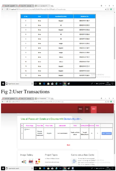
Fig 2:User Transactions
Fig 3: View all Places with Details and Distance with Dijsktra's Algorithm..
Fig 4: Shortest Path
Conclusion
In this paper, the proposed system works as Advanced
Path Planning by Caching, which shows the results
based on applying the proposed technique with GPS
and user deliberate change-1 and 2. From the source
and destination, the time and distance are calculated
based on the proposed system.
References