www.hydrol-earth-syst-sci.net/16/2685/2012/ doi:10.5194/hess-16-2685-2012
© Author(s) 2012. CC Attribution 3.0 License.
Earth System
Sciences
Quantitative analysis on the environmental impact of large-scale
water transfer project on water resource area in a changing
environment
D. H. Yan1,2, H. Wang1,2, H. H. Li1,2, G. Wang1,2, T. L. Qin1,2,3, D. Y. Wang1,2,3, and L. H. Wang1,2,4
1State Key Laboratory of Simulation and Regulation of Water Cycle in River Basin, China Institute of Water Resources and Hydropower Research, Beijing, 100038, China
2Water Resources Department, China Institute of Water Resources and Hydropower Research, Beijing, 100038, China 3Environmental Science and Engineering Department, Donghua University, Shanghai, 201620, China
4School of Hydraulic Engineering, Dalian University of Technology, Dalian, 116023, China
Correspondence to: G. Wang ([email protected])
Received: 19 October 2011 – Published in Hydrol. Earth Syst. Sci. Discuss.: 30 November 2011 Revised: 6 July 2012 – Accepted: 10 July 2012 – Published: 13 August 2012
Abstract. The interbasin long-distance water transfer project is key support for the reasonable allocation of water re-sources in a large-scale area, which can optimize the spatio-temporal change of water resources to secure the amount of water available. Large-scale water transfer projects have a deep influence on ecosystems; besides, global climate change causes uncertainty and additive effect of the environ-mental impact of water transfer projects. Therefore, how to assess the ecological and environmental impact of megapro-jects in both construction and operation phases has triggered a lot of attention. The water-output area of the western route of China’s South-North Water Transfer Project was taken as the study area of the present article. According to relevant evaluation principles and on the basis of background anal-ysis, we identified the influencing factors and established the diagnostic index system. The climate-hydrology-ecology coupled simulation model was used to simulate and predict ecological and environmental responses of the water resource area in a changing environment. The emphasis of impact evaluation was placed on the reservoir construction and oper-ation scheduling, representative river corridors and wetlands, natural reserves and the water environment below the dam sites. In the end, an overall evaluation of the comprehensive influence of the project was conducted. The research results were as follows: the environmental impacts of the western route project in the water resource area were concentrated on two aspects: the permanent destruction of vegetation during
the phase of dam construction and river impoundment, and the significant influence on the hydrological situation of nat-ural river corridor after the implementation of water extrac-tion. The impact on local climate, vegetation ecology, typical wetlands, natural reserves and the water environment of river basins below the dam sites was small.
1 Introduction
environmental issues and ecological influence (Graf, 2006; Morais, 2008; Braatne et al., 2008; Kittinger et al., 2009; Baran and Myschowoda, 2009; Growns et al., 2009; Wu et al., 2010; Olden and Naiman, 2010). At the same time, laws and regulations in terms of the construction and op-eration of water transfer projects were published so as to mitigate and even prevent the ecological and environmen-tal problems (Yang, 2003; Wang, 2009). Besides, studies on evaluation of ecological and environmental influence of wa-ter transfer projects have gradually developed into an impor-tant field (Doledec et al., 1996; Bombino et al., 2006; Shah and Kumar, 2008). Meanwhile, accompanied by the aggra-vation of the global climate change, the evaluation concern-ing the environmental influence of the water transfer project in a changing environment has become increasingly valued, and a few studies in this field were carried out (Zeilhofer and Moura, 2009; Olden and Naiman, 2010; D¨oll and Zhang, 2010; Moiwo et al., 2010; Pittock and Finlayson, 2011).
Megaprojects, especially those which cross rivers and are of long distance, are all huge systematic projects. They have a large span of space and time and therefore impose a broad array of impacts on the environment and ecosystems of a river basin (Petts, 1984; Casado et al., 1989; Poff et al., 1997; Rosenberg et al., 1997; Friedl and W¨uest, 2002; Brismar, 2004; Burke et al., 2009). What is more, the environmen-tal and ecological influence of project under the background of global climate change is extremely complex; thus, there is considerable uncertainty. Present relevant studies are short of global, comprehensive and systematic research as they are focused on a certain aspect of the environmental influence, such as the hydrological situation, pollutant transport pat-terns and biodiversity (Morais, 2008; Hu et al., 2008; Kout-sos et al., 2010; Ouyang et al., 2011), or they are targeted at a certain area, such as the water-output area, water-intake area and the river delta (Xu et al., 2011; Ligon et al., 2011; Restrepo and Cantera, 2011). The climate change aspect has been inadequately treated in the environmental impact as-sessment of large water transfer projects. Judging from the experiences of existing water transfer projects, the estimation of their impact on ecology and environment is insufficient, and the negative influence of projects in the phase of opera-tion is becoming increasingly significant. The western route of China’s South-North Water Transfer Project (SNWTP) water-output area is located in the first topographic ladder of China Qinghai-Tibet Plateau, an ecological fragile region and sensitive area of global climate change. Therefore, envi-ronmental and ecological impact assessment of this area is of great importance and has triggered a lot of concern (Yang et al., 2002; Berkoff, 2003; Ghassemi and White, 2006).
In the present article, some explorations of the evaluation of the ecological influence of the western route project on its water-output area in a changing climate were conducted. This study aims to contribute to show how, and to what extent, the western route project of SNWTP will impact ecology and en-vironment in water resource area and regions related to water
transfer. The specific objectives of this paper are to evaluate the influence of the water transfer (1) on the local climate of the water resource area after reservoir construction; (2) on the hydrological situation of typical dewatered river reaches; (3) on typical wetlands and natural reserves; and (4) on water environment below the dam sites.
2 Materials and methods
2.1 The study area
The first stage of western route project of SNWTP is located in the southeast edge of the Qinghai-Tibet Plateau (99◦200– 102◦100E, 31◦300–33◦200N). It covers seven counties in
three provinces, i.e. Qinghai, Sichuan and Gansu province. This region is characterized by a cold and dry highland cli-mate with an elevation above 3000 m. The average tempera-tures vary between minus 5–6◦C, and the annual precipita-tion amount is approximately 500–600 mm. The region has alternating dry and wet seasons exhibiting a distinct season-ality. The water resource area is located in the upstream re-gions of Yalong River and Dadu River, two main tributaries of the upper Yangtze River. The dam sites of water transfer are located in Ganzi section at the upper reaches of the Ya-long River’s mainstream; in Daqu and Niqu sections of the upper reaches of the Xianshuihe River, a branch of the Ya-long River; in Sequ and Duke sections of the upper reaches of Chuosijia River, the west branch of the Dadu River; and in Make and Ake sections of the upper reaches of Zumuzu River, the east branch of Dadu River. Seven water trans-fer reservoirs are scheduled to be constructed: Reba, Aan, Renda, Luoruo, Zhuanda, Huona and Keke, with catchments ranging between 1, 470–26, 535 km2. Figure 1 shows the ar-rangement of the western route project.
Fig. 1. Arrangement diagram of the project.
control plan, so as to give reasonable guidance to the plan-ning, construction and operation of the project.
2.2 Main considerations for the evaluation
According to the characteristics of large-scale water trans-fer projects, special importance was attached to the corre-lation and superimposed influence between projects and the interrelation among all kinds of ecological factors closely re-lated to water transfer in the process of evaluation. In view of the strategic level, the construction and operation of the whole water transfer project were integrated into the evalua-tion system.
First of all, background analysis on the eco-environment of the study area was conducted based on present meteoro-logical, hydrometeoro-logical, soil and vegetation information and the data collected by field survey. The influence identification and evaluation indices were determined based on relevant evaluation criteria. Then, based on the climate-hydrology-ecology coupled simulation model in conjunction with statis-tical methods, the influence analysis and quantitative evalua-tion were performed focusing on the four specific objectives of this paper. In the end, a comprehensive influence assess-ment on the ecological evolution of the water resource area was conducted.
2.3 Formulation of the evaluation index system
Firstly, eight primary indices of geography, atmosphere, hy-drology, soil, biology, population and economy, natural dis-aster and land deterioration including 137 secondary indices
were employed in order to give a comprehensive and objec-tive characterization of the ecology and environment of the upper stream of Yangtze River. And a hierarchical model was built to form a general characterization index system. Then, the 1–9 scale method in analytic hierarchy process (Saaty, 1987) was applied to mark the importance of the indices and build the structural judgment matrix for the possible influ-ence of the western route project on the environment. Five primary indices (i.e. atmosphere, water, biology, soil, natu-ral disaster and land deterioration) were chosen by analytic hierarchy process, and 32 secondary indices were then de-termined to form the characterization index system of envi-ronment in the water-output area. In the end, given the im-portance of the 32 indices, the sequence of their weight val-ues and the accessibility of the information as well, four pri-mary indices and 8 secondary indices directly to water trans-fer were chosen from the characterization index system to form the diagnostic indices of the environmental evolution of the water-output area.
2.4 Definition of the evaluation scale
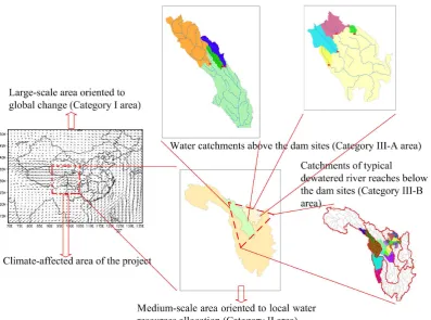
Fig. 2. The spatial scales for evaluation.
(Category III area), which include water catchments above the dam sites (Category III-A area) and typical dewatered reaches below the dam sites (Category III-B area). What is more, underlying surface change may lead to the modifi-cation of microclimate conditions; hence, the area of local climate change due to the project should be included (Cate-gory III-C area).
Therefore, evaluation was conducted on the following three scales: the Southeast Asia, the Yangtze River Basin above Yibin and the apparently affected areas (see Fig. 2). On the Southeast Asia scale, the main consideration was put on the response of the local environment to global climate change and the influence of underlying surface change on the climate; on the scale of Yangtze River Basin above Yibin, the emphasis of evaluation was placed on the influence of cli-mate change as well as the water transfer on the local water cycle and vegetation; and on the scale of the apparently af-fected areas, the evaluation was focused on the influence of project on the typical dewatered river reaches below the dam sites and the water storage areas above the dam sites.
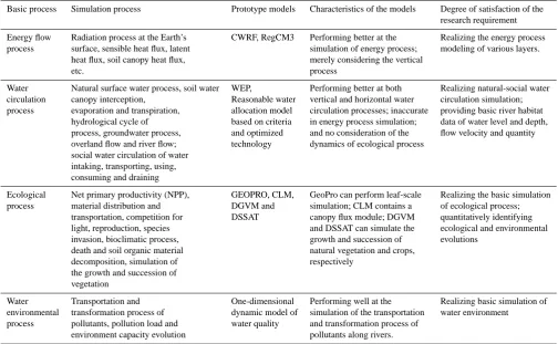
2.5 Development of the climate-hydrology-ecology coupled simulation platform
To identify the influence of the western route project of SNWTP on the ecology and environment of the water
resource area is the premise of the planning of the project, as well as the focus of arguments of stakeholders. Meanwhile, scientific prediction of the changes on the water circulation and environment of related areas is the key to forecast the transferable water amount in the process of project opera-tion. The key technical support for the two practical needs mentioned above requires the development of a climate-hydrology-ecology coupled simulation model and a forecast platform with integrated mechanism based on the multilayer observation of hydrology, meteorology/climate and ecology. The simulation platform should possess the following func-tions: (1) giving historical analogue simulation on the water circulation, ecological and environmental process of the wa-ter resource area; (2) identifying the main mechanism of mu-tual actions among climate, hydrology and ecology; (3) ob-jectively characterizing the key driving mechanism in the water circulation and ecological and environmental evolu-tions; and (4) simulating those evolutions under various eco-hydrological regulation scenarios.
Fig. 3. Framework of climate-hydrology-ecology coupled simulation model.
ecosystems with carbon circulation as the main line. The impact of the project on the aquatic ecosystems (e.g. fish habitats and life cycle) will be revealed by the results of quantitative evaluation on typical dewatered river reaches in Sect. 3.4.2. The framework and mutual actions among energy flow, natural-social water circulation and ecological process are shown in Fig. 3.
A large number of ecological models, hydrological els and climate models with relatively independent mod-ules have been developed worldwide, providing an impor-tant module database for the development of a climate-hydrology-ecology coupled simulation platform. The capa-bility of each model can be fully utilized through modular-ization strategies during the establishment of the comprehen-sive coupled model. In this study, the related modules of the regional climate-weather research and forecasting (CWRF)
Table 1. Selection of essential simulation process and the prototype models.
Basic process Simulation process Prototype models Characteristics of the models Degree of satisfaction of the research requirement
Energy flow Radiation process at the Earth’s CWRF, RegCM3 Performing better at the Realizing the energy process process surface, sensible heat flux, latent simulation of energy process; modeling of various layers.
heat flux, soil canopy heat flux, merely considering the vertical
etc. process
Water Natural surface water process, soil water WEP, Performing better at both Realizing natural-social water circulation canopy interception, Reasonable water vertical and horizontal water circulation simulation; process evaporation and transpiration, allocation model circulation processes; inaccurate providing basic river habitat
hydrological cycle of based on criteria in energy process simulation; data of water level and depth, process, groundwater process, and optimized and no consideration of the flow velocity and quantity overland flow and river flow; technology dynamics of ecological process
social water circulation of water intaking, transporting, using, consuming and draining
Ecological Net primary productivity (NPP), GEOPRO, CLM, GeoPro can perform leaf-scale Realizing the basic simulation process material distribution and DGVM and simulation; CLM contains a of ecological process;
transportation, competition for DSSAT canopy flux module; DGVM quantitatively identifying light, reproduction, species and DSSAT can simulate the ecological and environmental invasion, bioclimatic process, growth and succession of evolutions
death and soil organic material natural vegetation and crops,
decomposition, simulation of respectively
the growth and succession of vegetation
Water Transportation and One-dimensional Performing well at the Realizing basic simulation of environmental transformation process of dynamic model of simulation of the transportation water environment
process pollutants, pollution load and water quality and transformation process of environment capacity evolution pollutants along rivers.
model in a research report related to the western route project of SNWTP.1This paper focuses on the main findings with re-gard to the environmental and ecological impact of the water transfer project.
3 Results and discussion
3.1 The diagnostic index system
The diagnostic index system includes four primary indices for the criterion level and eight secondary indices for the dex level (Table 2). These indices can give about 70 % in-formation of the target level, which can basically meet the demand of the eco-environmental diagnosis of the water re-source area of the water transfer project. Relevant indices chosen from the diagnostic indices were used to give quanti-tative analysis of the influence of the project on the ecology and environment in typical affected areas.
1A research project (Assessment on the ecological and
environ-mental impact of the western route of SNWTP on the water-output area and comprehensive regulation technologies, Grant agreement no.: 2006BAB04A08) started by the Ministry of Science and Tech-nology of the People’s Republic of China in 2006.
3.2 The model performance
Table 2. Environmental and ecological diagnostic indices of the western route of SNWTP.
Target level Criterion level Index level Weight of index
Ecological and hydrological Atmosphere 0.1681 Annual average temperature 0.0922
regulation of the water resource Annual rainfall 0.1078
area of the western route of Dryness of atmosphere 0.0938
SNWTP Water 0.4631 Ecological flow 0.1745
Area of wetland 0.1656
Runoff coefficient 0.1344
Biology 0.2270 γ biodiversity index 0.1117
Land deterioration 0.1418 Soil erosion modulus 0.1199
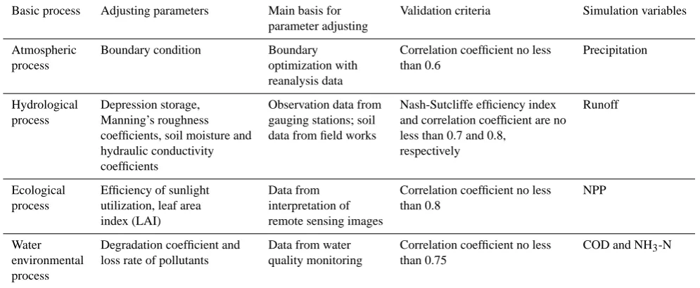
Table 3. Information for parameter adjusting.
Basic process Adjusting parameters Main basis for Validation criteria Simulation variables
parameter adjusting
Atmospheric Boundary condition Boundary Correlation coefficient no less Precipitation
process optimization with than 0.6
reanalysis data
Hydrological Depression storage, Observation data from Nash-Sutcliffe efficiency index Runoff
process Manning’s roughness gauging stations; soil and correlation coefficient are no
coefficients, soil moisture and data from field works less than 0.7 and 0.8,
hydraulic conductivity respectively
coefficients
Ecological Efficiency of sunlight Data from Correlation coefficient no less NPP
process utilization, leaf area interpretation of than 0.8
index (LAI) remote sensing images
Water Degradation coefficient and Data from water Correlation coefficient no less COD and NH3-N
environmental loss rate of pollutants quality monitoring than 0.75
process
3.3 Impact evaluation on the local climate of the water resource area
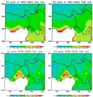
The regional climate characteristics are generally dominated by the atmospheric circulation. However, the microclimate conditions may be modified by significant underlying surface change. When the water transfer project is completely imple-mented, a total amount of 17 billion m3water will be diverted from the water resource area per year. The total water area of the eight newly built reservoirs will reach 289.9 km2, and the total area of terrestrial land directly affected by the project is approximately 3260 km2. Meanwhile, given the sensitiv-ity of the study area to global climate change, a future cli-mate scenario should be considered in the clicli-mate simulation and impact evaluation. Therefore, four scenarios were set up: the control experiment A (current climate without reservoirs) and contrast experiments B (current climate with reservoirs), C (future climate without reservoirs) and D (future climate with reservoirs). The modeling was carried out in two sepa-rate periods of current climate scenario (1993–2002) and fu-ture climate scenario (2040–2049) with a 30-km horizontal
resolution pattern. The computational domain is the Cate-gory III-C area defined in Sect. 2.4. The results are specified as follows:
1. Influence of the project on the local circumfluence and
temperature of the water resource area
In the current climate scenario, the reservoir construc-tion increases the wind speed in summer, autumn and winter by 0.3–0.8 m s−1. While the wind speed in spring is hardly affected, in the future climate scenario, the in-fluence on wind speed is insignificant, while the influ-ence on the humidity field at the location of 2 m is sig-nificant, which is reflected by the decrease of humidity in the northwest and increase in the Sichuan region in the east.
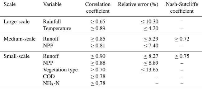
[image:7.595.49.547.231.436.2]Table 4. Results of model validation.
Scale Variable Correlation Relative error (%) Nash-Sutcliffe
coefficient coefficient
Large-scale Rainfall ≥0.65 ≤10.30 –
Temperature ≥0.89 ≤4.20 –
Medium-scale Runoff ≥0.85 ≤5.29 ≥0.72
NPP ≥0.81 ≤7.40 –
Small-scale Runoff ≥0.90 ≤8.27 ≥0.75
NPP ≥0.86 ≤6.89 –
Vegetation type ≥0.70 ≤13.65 –
COD ≥0.78 – –
NH3-N ≥0.78 – –
has some influence on the spatial distribution of local temperature: the low temperature area in the northwest of the water resource area decreases, while the central value of high temperature area in the Chengdu Plain in the east increases. In terms of the seasonal distribution, it has been observed that, after the reservoir construc-tion, the local temperature will rise in summer and wter and slightly decrease in spring and autumn. It in-creases by approximately 0.28◦C in winter.
2. Influence of the project on the local precipitation Through comparison of the simulation results of scenar-ios A and C, the spatial distribution of local precipita-tion changes significantly in a changing environment, and the high-value center in the south of Tibet moves northward. The regional precipitation tends to decrease on the whole by approximately 56 mm in the average annual value; through comparison of scenarios A and B, the reservoir construction has little impact on the local precipitation distribution under the current climate con-ditions. An increase of approximately 34 mm in the av-erage annual precipitation is only detected in the east of Sichuan province below the dam sites; through com-parison of scenarios C and D, the reservoir construc-tion exerts little impact on the regional average annual precipitation, which slightly increases by approximately 22 mm. The spatial distributions of average annual pre-cipitation under the four scenarios are shown in Fig. 4. In terms of the seasonal distribution, the precipitation tends to decrease in winter, spring and autumn after the reser-voir construction in future climate scenario, and the decrease by 19 % in spring is the most significant, while the precipita-tion in summer increases by approximately 7 %. The change of the spatial distribution of precipitation before and after the reservoir construction in the future climate scenario is shown in Fig. 5.
3.4 Impact evaluation on typical dewatered river reaches
3.4.1 Influence on the water amount of downstream river reaches
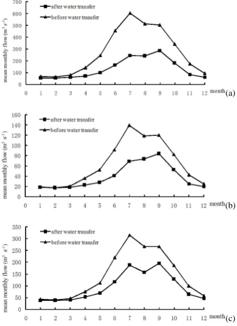
According to the diversion scheme of 8 billion m3water in the first stage of the western route project, the streamflow below the dam sites will significantly decrease after the op-eration of water transfer reservoirs. According to the monthly distribution plan with regard to discharge amount, it is in June that the main stream of Yalong River most suffers from water extraction, and the discharge amount of Reba reser-voir in June only accounts for 11.0 % of the mean monthly flow; the Xianshui River system also suffers from the most significant influence of the water transfer project in June, and the discharge amount of Aan and Renda reservoirs in June, compared with the mean monthly flow, decreases by 88.1 % and 89.6 %, respectively; the Sequ River of Chuosi-jia River system, where the Luoruo reservoir is located, is most influenced by the water extraction in October, with its mean monthly flow decreased by 83.6 %; the Dukehe River, where Zhuanda reservoir is located, is most influenced in June, with the mean monthly flow decreased by 92.1 %; the Zumuzu River system was most influenced by the water ex-traction in May. The water reduction of some typical river sections below the dam sites is shown in Fig. 6. The effects of stream dewatering will decrease with downstream distance from the dam sites due to inflow of tributaries. The stream-flow at Lianghekou section of Yalong River can recover to 55.2 % of that before the water extraction; streamflow at the river mouth of Xianshui River, Chuosijia River and Zumuzu River can be recover to 76.6–86.3 % of that before the water transfer.
3.4.2 Influence on hydraulic indices of downstream river reaches
Fig. 4. The spatial distribution of average annual precipitation under the four scenarios. (a) 1993–2002 without reservoirs; (b) 1993–2002
with reservoirs; (c) 2040–2049 without reservoirs; (d) 2040–2049 with reservoirs.
dramatic changes to the water depth, flow velocity, water surface width as well as surface area of the dewatered river reaches. The Ganzi section in the Yalong River is such a case, which is approximately 96 km downstream from the Reba dam. The average annual flow in this section is influenced by about 50.7 % by the water extraction. The mean monthly flow velocity after the water transfer is between 0.72 m s−1 and 1.44 m s−1, drastically reduced comparing with that before water transfer, especially during the rainy seasons. In the pe-riod of April to June when most fish species spawn, the mean flow velocity of the section will change from 1.11, 1.36 and 1.74 m s−1to 0.82, 0.97 and 1.18 m s−1, with a decrease of 25.9, 29.0 and 32.4 %, respectively. The mean water surface width and water depth show a similar decrease after the water transfer, and they are close to the minimum monthly values on the whole (see Fig. 7). The change in physical habitat con-ditions will result in a certain impact on the river ecology, and ecological regulation is needed to satisfy the basic habitat re-quirement of fish species. Meanwhile, the amount of water flowing into the dewatered reaches rises because of tributary inflows with downstream distance from the dam, mitigating the impact of the water transfer on hydrological regime.
3.5 Impact evaluation on the typical marsh wetlands
Fig. 5. The spatial distribution of seasonal average monthly precipitation of 2040–2049 under the scenarios of without reservoirs and with
reservoirs(a1, b1, c1 and d1 – spring, summer, autumn and winter, respectively, without reservoirs; a2, b2, c2 and d2 – spring, summer, autumn and winter, respectively, with reservoirs).
below the dam sites due to dam regulation, negatively influ-encing approximately 5.0 % of the wetland.
The hydrological factor is the most important environ-mental factor contributing to the scope, composition, struc-ture and quality of the wetland. The change of hydrological
Table 5. Integrated evaluation of the influence of the western route project on marsh wetlands.
Wetlands classified Area Range of influence Influence effect Degree of Influence type
according to their affected by Integral Local Percentage Positive influence Recoverable Irreparable
water recharging the project influence influence or
types negative
Water 70 % No Out of the influence range of the water extraction
recharging via overland flow
Water 30 % 20 % No Locating in the upstream regions far away from dam sites
recharging 10 % Yes Yes 2 % + 0.2 %
via river 8 % − 5.0 % 3.5 % 1.5 %
flow
Note: “+” means a positive impact and “−” means a negative impact. The same below.
(a)
(b)
(c)
Fig. 6. Comparison of the mean monthly flow of some typical river
sections before and after water transfer. (a) Ganzi section in Yalong River, (b) Zhuba section in Niqu River and (c) Daofu section in Xianshui River.
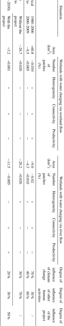
in Table 6. Comparing the two historical scenarios, the land-scape pattern of marsh wetlands shows obviously distinct evolution characteristics. During the period of 1980–2000, both the wetlands charging via overland flow and river flow increase in their areas accompanied by enhancement of the heterogeneity, connectivity and productivity on the whole, while during 2000–2009, the situation changes in the op-posite direction. Both climate change and human activities play important roles in the wetland evolution, and their de-grees of influence drastically vary in different phases. Under the future scenario without the project, the marsh wetlands will show a significant decrease mainly resulting from unrea-sonable human activities (accounting for 70 %). The project has an overall positive impact on the marsh wetlands under a changing environment. This indicates that the modifica-tion of microclimatic condimodifica-tions due to reservoir construcmodifica-tion may offset the degeneration of wetlands to some degree.
3.6 Impact evaluation on the natural reserves
[image:11.595.47.287.281.611.2](a)
(b)
(c)
Fig. 7. Influence on the average flow velocity, water surface width
and water depth at the Ganzi section of Yalong River. (a) Mean flow velocity, (b) mean water surface width and (c) mean water depth.
downstream from the dam will drastically decrease. How-ever, with an ecological operation, the discharge flow can ba-sically satisfy the ecological water requirement.
3.7 Impact evaluation on the water environment below the dam sites
3.7.1 Influence on the water quality of main river reaches below the dam sites
Given the change of socio-economic level, pollution dis-charge, and water resource allocation in different phases of development, the influence of water transfer on the water
environment below the dam sites is discussed in three tar-get years: 2010 (present), 2020 and 2030 (future). For the Ake River reaches, the five-day biochemical oxygen demand (BOD5) can meet the standard I of surface water quality, and the chemical oxygen demand (COD) and ammonia-N (NH3 -N) can meet the standard II in the three target years under the scenarios of water extraction, average annual flow and with-out consideration of pollution control. During the dry sea-son in February, water quality above and below Aba county section on Ake River is different. In the target year of 2010, BOD5can meet the standard I and both COD and NH3-N can meet the standard II for the whole reaches of Ake River af-ter waaf-ter extraction. The waaf-ter quality will not show obvious change in the future target years of 2020 and 2030 for the Ake River reaches upstream from the Aba country section, while, the predicted values of the three indices show a dis-tinct change for the reaches below the Aba section. In 2020, the water quality of the 79-km reach from the Aba section to the Ake River mouth will degrade to the standard IV and standard III with a river length of 43 km and 36 km, respec-tively. Comparing to the scenario without water extraction, the maximum values of the concentration of BOD5, COD and NH3-N in Aba section increase by 13, 4 and 24 %, re-spectively. And the reach length of standard IV increases by 18 km. In 2030, the water quality in the Aba county section will degrade to the standard V, and the water quality of the whole 79-km reach will merely meet the standard IV. The maximum values of BOD5, COD and NH3-N in Aba sec-tion increase by 13, 3 and 8 %, respectively, and the reach length of standard IV increases by 9 km compared to the sce-nario without water extraction. On the whole, without pollu-tion control, the water extracpollu-tion will significantly degrade the water quality below the Aba section with a relatively high pollution load. The limit values of COD, BOD5 and NH3-N for different water categories are extracted from the environmental quality standards for surface water of China (GB 3838-2002), as shown in Table 7.
With pollution control, the water quality will be signif-icantly improved. During the dry season in February, the BOD5 can meet the standard I and both COD and NH3-N can meet the standard II for the whole reaches of Ake River except the Aba country section, in the future target years of 2020 and 2030. The concentration of BOD5in Aba county section slightly exceeds the standard II and is in line with the standard III. The result indicates that the water quality can be raised by 1–2 levels with the implementation of pollution control measures. The water quality of Ake River reaches in February under different scenarios is shown in Fig. 8.
[image:13.595.48.289.77.499.2]Table 7. The limit values of COD, BOD5and NH3-N for the surface water quality standards unit (mg l−1.)
Items Standard I Standard II Standard III Standard IV Standard V
COD≤ 15 15 20 30 40
BOD5≤ 3 3 4 6 10
NH3-N≤ 0.15 0.5 1.0 1.5 2.0
Fig. 8. The water quality of Ake River reaches below the dam sites in February under different scenarios. (a), (b), (c) The three target years
of 2010, 2020 and 2030, respectively, without pollution control; (d) 2010 with pollution control, (e) 2020 and 2030 with pollution control.
to reduce the ammonia pollution in the river reaches below the dam sites and improve the water quality to some degree.
3.7.2 Influence on the water environmental capacity in the county sections
Based on the water quality objective (standard II) of water function zoning, the influence of water extraction on the ca-pacity of water environment in the county sections is ana-lyzed. The water environmental capacity of COD and NH3 -N decreases by 13–32 % resulting from a substantial reduc-tion in the river flows after the water extracreduc-tion. The Ake River, the most sensitive river to the water reduction, will suffer from a serious water quality problem, and the pollution control measures are needed. However, the surplus capacity of water environment of the other rivers related to the water transfer project remains high. This indicates that the project
overall has a limited effect on the water environmental ca-pacity of reaches below the dam sites.
3.8 Overall evaluation of the comprehensive influence
On the basis of the results of single-item evaluation, the de-grees of influence of each influencing items were classified by the expert estimation system. Overall evaluation of the comprehensive environmental impact of the western route project of SNWTP is intuitively shown in Figs. 9 and 10. The color sectors are related to a scale of impact, and the sectors of the outside lanes indicate a higher impact scale than that of inside ones.
Fig. 9. Overall evaluation of the comprehensive environmental impact of the project (1).
[image:15.595.125.470.398.659.2]river corridors after the implementation of water extraction. The influence on local climate and vegetation, typical marsh wetlands, natural reserves and water environment below the dam sites is limited.
4 Conclusions
Based on the practical needs of the impact evaluation of the western route project of SNWTP in a changing climate and supported by a climate-hydrology-ecology coupled simula-tion model, quantitative analysis on three different scales of space has been undertaken, focusing on local climate, typical dewatered river reaches, typical marsh wetlands, natural re-serves and the water environment downstream from the dam sites. The conclusions are as follows:
1. The influence on the local climate of the water re-source area: the reservoir construction has little influ-ence on the wind speed and temperature in the water resource area. While a relatively significant change in the regional humidity field and precipitation distribu-tion is observed under the changing environment with the reservoir construction, the average annual rainfall increases by approximately 22 mm.
2. The influence on typical dewatered river reaches: after the water extraction, the downstream channel flow will suffer from a sharp decrease, accompanied by the dras-tic change of hydraulic indices of the water depth, the flow velocity, the water surface width and surface area. The altering hydrological regime results in a certain im-pact on the river ecology. Meanwhile, the amount of wa-ter flowing into the dewawa-tered reaches rises due to trib-utary inflows with downstream distance from the dam, mitigating the negative impact of water reduction.. 3. The influence on typical marsh wetlands: approximately
10 % of riverine wetlands near the dam sites will be partly affected by the project. The enhanced flooding ef-fect and water recharging efef-fect from the riverside may positively increase the area of wetlands above the dam sites. The project seems to have an overall positive im-pact on the marsh wetlands under a changing environ-ment because of the reservoir-induced modification of microclimatic conditions.
4. The influence on natural reserves: the construction-induced vegetation destruction and submergence of veg-etation in the reservoir regions will inevitably dam-age the biodiversity in the natural reserves. Though the newly formed reservoir wetlands may provide new habi-tats for species like waterfowl and wading birds, their impact on the biodiversity is uncertain.
5. The influence on the water quality of the lower reaches: the water extraction has a significant effect on the water
quality of Ake River especially in the Aba county sec-tion due to a high pollusec-tion load and a reduced water environmental capacity. The water quality level can be apparently raised with the implementation of pollution control measures. The water quality of the other seven rivers with relatively high surplus capacities of water environment will not show significant degeneration. In addition, the concentration of ammonia in the initial stage of rainy season shows a dramatic decrease by 27– 41 % with the purification effect of the water transfer reservoirs.
Acknowledgements. The authors would like to thank the the guest editor and two anonymous reviewers for their helpful comments, which improved the quality of the final manuscript. This study is jointly funded by the National Key Project of Scientific and Technical Supporting Program (Grant No. 2006BAB04A08) and Innovation Research Group Foundation Programme of Natural Science Foundation of China (Grant No. 51021066).
Edited by: A. Ghadouani
References
Baran, E. and Myschowoda, C.: Dams and fisheries in the Mekong Basin, Aquat. Ecosyst. Health, 12, 227–234, 2009.
Berkoff, J.: China: The South-North Water Transfer Project – is it justified?, Water Policy, 5, 1–28, 2003.
Bombino, G., Tamburino, V., and Zimbone, S. M.: Assessment of the effects of check-dams on riparian vegetation in the mediter-ranean environment: a methodological approach and example ap-plication, Ecol. Eng., 27, 134–144, 2006.
Braatne, J. H., Rood, S. B., Goater, L. A., and Blair, C. L.: Ana-lyzing the impacts of dams on riparian ecosystems: a review of research strategies and their relevance to the Snake River through Hells Canyon, Environ. Manage., 41, 267–281, 2008.
Brismar, A.: Attention to impact pathways in EISs of large dam projects, Environ. Impact Assses., 24, 59–87, 2004.
Burke, M., Jorde, K., and Buffington, J. M.: Application of a hier-archical framework for assessing environmental impacts of dam operation: Changes in streamflow, bed mobility and recruitment of riparian trees in a western North American river, J. Environ. Manage., 90, 224–236, 2009.
Casado, C., Carcia de Jalon, D., Delolmo, C. M., Barcelo, E., and Menes, F.: The effect of an irrigation and hydroelectric reservoir on its downstream communities, Regul. River., 4, 275–284, 1989. Davies, B. R., Thoms, M., and Meador, M.: An assessment of the ecological impacts of interbasin water transfers, and their threats to river basin integrity and conservation, Aquat. Conserv., 2, 325–349, 1992.
Doledec, S., Dessaix, J., and Tachet, H.: Changes within the Up-per Rhone River macrobenthic communities after the completion of three hydroelectric schemes: anthropogenic effects or natural change?, Arch. Hydrobiol., 136, 19–40, 1996.
Friedl, G. and W¨ust, A.: Disrupting biogeochemical cycles: conse-quences of damming, Aquat. Sci., 64, 55–65, 2002.
Ghassemi, F. and White, I.: Inter-Basin Water Transfer: Case studies from Australia, United States, Canada, China, and India, Cam-bridge Univ. Press, New York, 2006.
Graf, W. L.: Downstream hydrologic and geomorphic effects of large dams on American rivers, Geomorphology, 79, 336–360, 2006.
Growns, I., Reinfelds, I., Williams, S., and Goade, G.: Longitudi-nal effects of a water supply reservoir (Tallowa Dam) on down-stream water quality, substrate and riffle macroinvertebrate as-semblages in the Shoalhaven River, Australia, Mar. Freshwater Res., 60, 594–606, 2009.
Hu, W. W., Wang, G. X., Deng, W., and Li, S.: The influence of dams on ecological conditions in the Huaihe River basin, China, Ecol. Eng., 33, 233–241, 2008.
Ji, J. F., Shen, J., Balsam, W., Chen, J., Liu, L. W., and Liu, X. Q.: Asian monsoon oscillations in the northeastern Qinghai– Tibet Plateau since the late glacial as interpreted from visible reflectance of Qinghai Lake sediments, Earth Planet. Sc. Lett., 233, 61–70, 2005.
Jia, Y. W., Ni, G. H., Kawahara, Y., and Suetsugi, T.: Development of WEP model and its application to an urban watershed, Hydrol. Process., 15, 2175–2194, 2001.
Jones, J. W., Hoogenboomb, G., Porter, C. H., Boote, K. J., Batch-elor, W. D., Hunt, L. A., Wilkens, P. W., Singh, U., Gijsman, U., and Ritchie, J. T.: The DSSAT cropping system model, Eur. J. Agron., 18, 235–265, 2003.
Kittinger, J. N., Coontz, K. M., Yuan, Z. P., Han, D. J., Zhao, X. F., and Wilcox, B. A.: Toward holistic evaluation and assessment: linking ecosystems and human well-being for the Three Gorges Dam, Ecohealth, 6, 601–613, 2009.
Koutsos, T. M., Dimopoulos, G. C., and Mamolos, A. P.: Spatial evaluation model for assessing and mapping impacts on threat-ened species in regions adjacent to Natura 2000 sites due to dam construction, Ecol. Eng., 36, 1017–1027, 2010.
Liang, X. Z., Choi, H., Kunkel, K. E., Dai, Y., Joseph, E., Wang, J. X. L., and Kumar, P.: Development of the regional climate-weather research and forecasting model (CWRF): Sur-face boundary conditions, Illinois State Water Survey Scientific Research, ISWS SR 2005-01, Springfield, 2005a.
Liang, X. Z., Xu, M., Zhu, J., Kunkel, K. E., and Wang, J. X. L.: De-velopment of the regional climateweather research and forecast-ing model (CWRF): Treatment of topography, in: Proceedforecast-ings of 2005 WRF/MM5 User’s Workshop, Boulder, CO, 2005b. Liang, X. Z., Xu, M., Yuan, X., Ling, T., Choi, H. I., Zhang,
F., Chen, L., Liu, S., Su, S., Qiao, F., He, Y., Wang, J. X. L., Kunkel, K. E., Gao, W., Joseph, E., Morris, V., Yu, T. W., Dudhia, J., and Michalakes, J.: Regional Climate-Weather Re-search and Forecasting Model (CWRF), B. Am. Meteorol. Soc., doi:10.1175/BAMS-D-11-00180.1, in press., 2012.
Ligon, F. K., Dietrich, W. E., and Trush, W. J.: Downstream ecolog-ical effects of dams, Bioscience, 45, 183–192, 2011.
Liu, X. D. and Chen, B. D.: Climatic warming in the Tibetan Plateau during recent decades, Int. J. Climatol., 20, 1729-1742, 2000.
Meador, M. R.: Inter-basin Water Transfer: Ecological Concerns, Fisheries, 17, 17–22, 1992.
Moiwo, J. P., Yang, Y. H., Li, H. L., Han, S. M., and Yang, Y. M.: Impact of water resource exploitation on the hydrology and water storage in Baiyangdian Lake, Hydrol. Process., 24, 3026–3039, 2010.
Morais, P.: Review on the major ecosystem impacts caused by damming and watershed development in an Iberian basin (SW-Europe): focus on the Guadiana estuary, Ann. Limnol.-Int. J. Lim., 44, 105–117, 2008.
Nardini, A., Blanco, H., and Senior, C.: Why didn’t EIA work in the Chilean project canal lajadiguillın?, Environ. Impact Assess., 17, 53–63, 1997.
Olden, J. D. and Naiman, R. J.: Incorporating thermal regimes into environmental flows assessments: modifying dam operations to restore freshwater ecosystem integrity, Freshwater Biol., 55, 86– 107, 2010.
Oleson, K. W., Dai, Y., Bonan, G., Bosilovich, M., Dickinson, R., Dirmeyer, P., Hoffman, F., Houser, P., Levis, S., Niu, G. Y., Thornton, P., Vertenstein, M., Yang, Z. L., and Zeng, X.: Technical description of the Community Land Model (CLM), Tech. Rep. NCAR/TN-461+STR, National Center for Atmo-spheric Research, Boulder, CO, 2004.
Ouyang, W., Hao, F. H., Song, K. Y., and Zhang, X.: Cascade Dam-Induced Hydrological Disturbance and Environmental Impact in the Upper Stream of the Yellow River, Water Resour. Manag., 25, 913–927, 2011.
Pal, J. S., Giorgi, F., Bi, X., Elguindi, N., Solmon, F., Gao, X., Rauscher, S. A., Francisco, R., Zakey, A., Winter, J., Ashfaq, M., Syed, F. S., Bell, J. L., Diffenbaugh, N. S., Karmacharya, J., Konar, A., Martinez, D., da Rocha, R. P., Sloan, L. C., and Steiner, A. L.: Regional climate modeling for the developing world, The ICTP RegCM3 and RegCNET, B. Am. Meteorol. Soc., 88, 1395–1409, 2007.
Petts, G. E.: Impounded rivers: perspectives for ecological manage-ment, Wiley, Chichester, UK, 1984.
Pittock, J. and Finlayson, C. M.: Australia’s Murray-Darling Basin: freshwater ecosystem conservation options in an era of climate change, Mar. Freshwater Res., 62, 232–243, 2011.
Poff, N. L., Allan, J. D., Bain, M. B., Karr, J. R., Prestegaard, K. L., Richter, B. D., Sparks, R. E., and Stromberg, J. C.: The natural flow regime: a paradigm for river conservation and restoration, Bioscience, 47, 769–784, 1997.
Restrepo, J. D. and Cantera, J. R.: Discharge diversion in the Pat´ıa River delta, the Colombian Pacific: Geomorphic and ecological consequences for mangrove ecosystems, J. S. Am. Earth Sci., doi:10.1016/j.jsames.2011.04.006, in press, 2011.
Rosenberg, D. M., Berkes, F., Bodaly, R. A., Hecky, R. E., Kelly, C. A., and Rudd, J. W. M.: Large-scale impacts of hydroelectric development, Environ. Rev., 5, 27–54, 1997.
Saaty, R. W.: The analytic hierarchy process – what it is and how it is used, Math. Model., 9, 161–176, 1987.
Shah, Z. and Kumar, M. D.: In the midst of the large dam contro-versy: objectives, criteria for assessing large water storages in the developing world, Water. Resour. Manage., 22, 1799–1824, 2008.
Wang, G. Q.: World water transfer projects, Beijing, Science Press, 2009.
Wu, N., Tang, T., Fu, X., Jiang, W., Li, F., Zhou, S., Cai, Q., and Fohrer, N.: Impacts of cascade run-of-river dams on benthic di-atoms in the Xiangxi River, China, Aquat. Sci., 72, 117–125, 2010.
Xu, X. B., Tan, Y., Yang, G. S., Li, H. P., and Su, W. Z.: Impacts of China’s Three Gorges Dam Project on net primary productivity in the reservoir area, Sci. Total Environ., 409, 4656–4662, 2011. Yang, L. X.: Foreign water transfer projects, Beijing, China Water
Power Press, 2003.
Yang, S. T., Liu, C. M., Yang, Z. F., Sun, R., and Zhou, X. D.: Nat-ural Eco-environmental Evaluation of West Route Area of Inter-basin Water Transfer Project, Acta Geogr. Sin., 57, 11–18, 2002. Yuan, X. and Liang, X. Z.: Improving cold season precipitation pre-diction by the nested CWRF-CFS system, Geophys. Res. Lett., 38, L02706, doi:10.1029/2010GL046104, 2011.
Zeilhofer, P. and de Moura, R. M.: Hydrological changes in the northern Pantanal caused by the Manso dam: Impact analysis and suggestions for mitigation, Ecol. Eng., 35, 105–117, 2009. Zhao, Y., Lu, C. Y., and Xiao, W. H.: Study on rational deployment