ISSN 2250-3153
Utilization of WRF-Chem Modelling for Barujari Mount
of Volcanic Ash Distribution Analysis
Pande Putu Hadi Wiguna*, Kadek Setiya Wati**, Fajar Setiawan***
Indonesian Academy of Meteorology, Climatology and Geophysics (STMKG) Jakarta, Indonesia*
Indonesian Meteorological, Climatological and Geophysical Agency (BMKG) Lombok International Airport, West Nusa Tenggara, Indonesia** Indonesian Meteorological, Climatological and Geophysical Agency (BMKG) Perak, Surabaya, Indonesia ***
Abstract- By the development of NWP (Numerical Weather Prediction), the using of weather model is used to being done and it get better and better. Starting from a Rick Anthes’ 3-layer hurricane model on 1960, a mesoscale model on 1970s, MM4 on 1980s and MM5 model on 1990s which was developed until the third version. Then WRF (Weather Research and Forecasting) launched in beta version up to now WRF was launched with different core in ARW and NMM with additional modules which is also included in WRF-Chem and WRF-Fire. WRF-Chem is a WRF Mode that has chemistry additional module which is able to simulate air quality on regional scale, on field analysis and interaction analysis between clouds and chemical particles in atmosphere. The eruption of Barujari Mount in Lombok island on 4th of November 2015 caused 3 airports was closed, they are International Airport of Lombok, Ngurah Rai Airport and Banyuwangi Airport. The height of Barujari Mount is about 2376 ms above sea level. The height of Barujari mount’s eruption reached about 20,000 feets. To analyse volcanic ash spread using WRF-Chem model, we can use NCEP FNL on 3rd of November 2015 on 00.00 UTC until 5th of November 2015 on 00.00 UTC. NCEP FNL is a product from GDAs which is a global data asimilation system that is frequently collectingdata from GTS. Volcanic ash spreading data from Himawari-8 is used as a comparison. From the analysis model using WRF-Chem, volcanic ash on 850 mb layer until 500 mb on spreading to South West until West area of Lombok island. It shows the conformity in spreading direction on Himawari-8 images. Even though, there are several differences with Himawari-8 where spreading direction on WRF-Chem went to West-North West and Himawari-8 satellite images showed the spreading volcanic ash moved to South West-West of Lombok island.
Keyword: WRF-Chem, Barujari Mount, Volcanic ash, Himawari-8 Satellite
I. INTRODUCTION
WRF Model (Weather Research and Forecasting) is an atmosphere model, the next generation of MM5 which was stopped for its development, this model applies meteorological research using NWP (Numerical Weather Prediction). WRF gives
most applicable in their research. Beside that, WRF can be run on many computer platform. This model is good for research on tens meters scale until global scale.
WRF model has 2 different cores. Even though these cores are different, they have same architecture program, they are :
1) ARW (Advanced Research WRF) which is developed by NCAR in MMM laboratory.
2) NMM (Non-hydrostatic Mesoscale Model) which is developed by NCEP.
WRF-Chem is one of development from WRF model which is combined with chemical particle or chemistry. This model is used to investigate air quality on regional scale, on field analysis, and also cloud and chemical particles interaction analysis in atmosphere.
Chemistry module on WRF-Chem is necessary for the grid emision input data. The input data is made by WPS (on dust erosion) or on real.exe (biogenic emission, GOCART, biomass burning, etc.) or it read along execution process on WRF (anthropogenic emission, volcanic emission, etc.). The emission input data creation for the atmosphere chemistry simulation becomes so complex, not all of emission selection useful for every namelist selection on WRF-Chem. A user has to be able to modify the script and configure it to get the best model.
WRF-Chem has 5 scheme in aerosol handling, they are :
1) Efficient aer osol sch eme fr om GOCART (Georgia Tech/Goddard Global Ozone Chemistry Aerosol Radiation and Transport model).
2) Modal Aerosol Dynamics Model for Europe – MADE 3) Model for Simulating Aerosol Interactions and Chemistry
(MOSAIC).
4) MAM – Modal Aerosol Model from CAM5 5) Volcanic dust aerosol division scheme (bin)
ISSN 2250-3153
Chemistry and Atmospheric
Process
Model Option
Chemistry Volcanic ash fall and concentration only Photolysis No photolysis Anthropogenic
Emissions
GOCART simple emissions
Biogenic Emissions No biogenic emissions
Biomass Burning Emissions
Include biomass burning emissions and plume rise calculation
Dust Emissions GOCART dust
emissions Aerosol Optical Properties
Aerosol optical properties calculated based upon volume approximation Gas phase chemistry Turn on Aerosol chemistry Turn on Feedback from the
aerosol
feedback from the aerosols to the radiation schemes turned on
Sub grid convective transport
Turn on These are the classification for 10-bin scheme volcanic ash in
[image:2.612.345.545.61.292.2]WRF-Chem :
Table I. Clasification of 10-bin scheme volcanic ash
Particle Size Bin Phi % of mass
1 – 2mm -1 – 0 2
0.5 – 1 mm 0 – 1 4
0.25 – 0.5 mm 1 – 2 11
125 – 250 µm 2 – 3 9
62.5 – 125 µm 3 – 4 9
31.25 – 62.5 µm 4 – 5 1 15.625 – 31.25 µm 5 – 6 16 7.8125 – 15.625 µm 6 – 7 16
3.9065 – 7.8125 µm 7 – 8 10
< 3.9 µm > 8 10
This research is held to use WRF-Chem model as a model that can simulate and analyse volcanic ash spreading on Barujari Mount in 4th of November 2015. Barujari mount is a part of Rinjani Mount in Lombok island, West Nusa Tenggara, Indonesia. Volcanic ash spreading on 4th of November 2015 moved to West and caused the airports in Lombok, Denpasar and Banyuwangi was closed.
WRF-Chem is hopefully able to analyse and predict volcanic ash spreading in the next day so that it can give eralier and more accurate information on decision making by authorized institution.
II. DATA AND METHODS This research uses several data, they are :
1) NCEP FNL data on November 3– 5 , 2015 from http://rda.ucar.edu/datasets/ds083.2/index.html#sfol-wl-/data/ds083.2?g=22015
2) Satellite image for volcanic ash spreading on 4th of November 2015 from Himawari-8 for comparison with WRF-Chem model output.
NCEP FNL (Final) data is global analysis data that has 1o resolution in every 6 hours. This data is a product from GDAs which is a global data asimilation system that collect data from GTS (UCAR, 2016) continously. BMKG (Indonesian Meteorological and Geophysics Agency) is also a member for this world GDAs and GTS where BMKG’s data is also exchanged. This NCEP FNL data will be used for first input in WRF-Chem models.
This research uses WRF-Chem 3.61 that run on LINUX Ubuntu v.14 Operating System. The configuration domain for this research are:
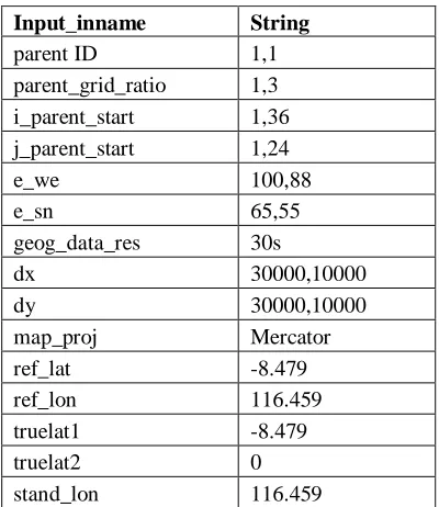
Table II. WRF- Chem Domain Configuration
Input_inname String
parent ID 1,1
parent_grid_ratio 1,3 i_parent_start 1,36 j_parent_start 1,24
e_we 100,88
e_sn 65,55
geog_data_res 30s
dx 30000,10000
dy 30000,10000
map_proj Mercator
ref_lat -8.479
ref_lon 116.459
truelat1 -8.479
truelat2 0
stand_lon 116.459
These are chemistry modules configuration run on WRF-Chem in this research :
ISSN 2250-3153
Cumulus scheme Grell 3D Microphysics Lin et al. scheme Shortwave radiation RRTMG scheme Longwave radiation RRTMG scheme Land surface model Noah Land Surface
Model
Surface-layer MM5 similarity
Boundary-layer Yonsei University scheme
Number of x grid points
e_we = 67, 70
Number of y grid points
e_sn = 67, 70
Map projection Mercator Grid point of Resolution in x (meter)
dx = 30000, 10000
Grid point of Resolution in y (meter)
dy = 30000, 10000
Central Latitude of Model Domain (degrees)
-8.479
Central Longitude of Model Domain (degrees)
116.459
Time step 180
Initial conditions NCEP FNL
Operational Model Global Tropospheric Analyses
Lateral boundary conditions
NCEP FNL Operational Model Global Tropospheric Analyses
A WRF-Chem model perform real.exe twice. The first process is performed to get meteorological data on every domain and the second process is performed to join the output fo chemistry module in every domain so that it creates the output that combine meteorological and chemistry data in one WRF-Chem model execution process.
[image:3.612.59.269.55.474.2]The execution process for this model can be seen in this illustration:
Figure 1: Flow chart for WRF-Chem modelling
After execution for data processing using WRF-Chem models, the next step is analysis using supporting image for volcaninc ash image from Himawari-8.
III. ANALYSIS AND DISCUSSION
A. WRF Chem Model Analysis
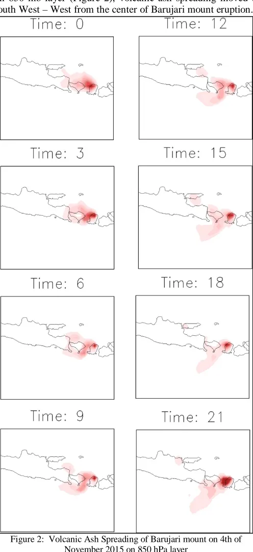
[image:3.612.321.569.129.669.2]On 850 mb layer (Figure 2), volcanic ash spreading moved to South West – West from the center of Barujari mount eruption.
Figure 2: Volcanic Ash Spreading of Barujari mount on 4th of November 2015 on 850 hPa layer
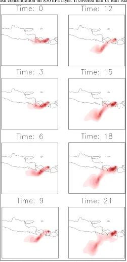
[image:3.612.36.305.589.689.2]ISSN 2250-3153
concentration visible on 700 hPa layer was thicker than volcanic ash concentration on 850 hPa layer. It covered half of Bali island
[image:4.612.322.570.61.609.2]especially on south on 700 hPa layer.
Figure 3: Volcanic Ash Spreading of Barujari mount on 4th of November 2015 on 700 hPa layer
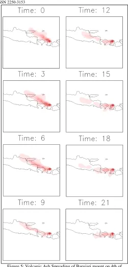
Figure 4 shows data on 00.00 UTC to 12.00 UTC, volcanic ash spreading on 500 hPa layer mostly moved to West with the dust dispersion is concentrated more on Lombok island. Less concentration of volcanic ash covered almost all Bali island and a little area on East Java. Begin from 12.00 UTC, dispersion of dust was not so far as began to be sporadic. Thick spreading tends to cover Lombok island and dispersed less to the South of Lombok island.
Figure 4: Volcanic Ash Spreading of Barujari mount on 4th of November 2015 on 500 hPa layer
[image:4.612.37.288.80.598.2]ISSN 2250-3153
Figure 5: Volcanic Ash Spreading of Barujari mount on 4th of November 2015 on 500 hPa layer
3.2 Himawari-8 Satellite Analysis
[image:5.612.313.575.58.424.2]Figure 6 at 00.00 UTC, volcanic ash spreading moved to North West – West from Lombok island. Volcanic ash covered almost all of Bali island until East Java. At 03.00 UTC and 06.00 UTC, volcanic ash was dispersed on the same direction with the direction on 00.00 UTC, but it got thicker, where pink color looked to be thicker than before. On 09.00 UTC, volcanic ash began to be dispersed, covered most of Lombok island and half of Bali island. On 15.00 UTC, volcanic ash spreading got thicker and thicker on Lombok island, it spread to most of Bali island on Southwest-West direction.
Figure 6: Volcanic ash spreading on Barujari Mount on 4th of November 2015 via Satellite Image of Himawari-8
IV. CONCLUSION
From the output of WRF-Chem modelling, volcanic ash spreading of Barujari Mount on 850 hPa, 700 hPa and 500 hPa on 4th of November 2015 was visibly moving to South West – West. Except on 400 hPa layer, the spreading of volcanic ash moved to West – Northwest.
Volcanic ash spreading on 850 hPa and 700 hPa seemed to have more dust concentration than volcanic ash spreading on 500 hPa and 400 hPa.
Volcanic ash spreading was visibly detected on Himawari-8 could be explained well on WRF-Chem model on 850 hPa and 700 hPa layer. On 500 hPa layer, the direction of its spreading has been similar to satellite image, but the spreading distance was not as far as the distance on satellite image. On 400 hPa layer, there is a difference in volcanic ash spreading direction on 00.00 UTC until 09.00 UTC where the direction on model showed spreading direction to North West, and the spreading direction on satellite image moved to West from Lombok island. The using of WRF-Chem model is good enough to simulate volcanic ash spreading, because it is not disturbed by meteorological cloud which can cover volcanic ash, it can also detect until the smallest particles of volcanic ash which is under 3.9 µm where this research uses its size. However, the using of WRF-Chem to find the distribution of volcanic ash needs to be
00 UTC 03 UTC
06 UTC 09 UTC
12 UTC 15 UTC
ISSN 2250-3153
verified with the real condition using Satellite image or visual observation.
REFERENCES
[1] Grell, G., Peckham, S.E., Mckeen, S.A., et al, 2015, Introduction to WRF-Chem, [daring] (http://ruc.noaa.gov/wrf/WG11/wrf_tutori al_2015/WRF_CHEM_Overview.pdf, acces on 09th of March 2016). [2] Kazil, Jan, 2015, Aerosol Modeling with WRF/Chem, University of
Colorado, NOAA Earth System Research Laboratory.
[3] Nuryanto, 2014, FGD dan Pelatihan Pemodelan Kimia Atmosfer, WRF-Chem, Puslitbang BMKG, Jakarta
[4] UCAR, 2016, RDA dataset description, [daring] (http://rda.ucar.edu/datasets/ds083.2/#!de scription, access on 13th of March 2016).
[5] Knievel, Jason, 2005, The WRF Model, National Center for Atmospheric Research Boulder, CO, USA
[6] Peckham, Steven E., 2015, WRF-Chem: A Quick Review of How to Set-Up & Run, [daring] (http://ruc.noaa.gov/wrf/WG11/wrf_tutori al_2015/WRF_CHEM_setup.pdf, access on 16th of March 2016).
AUTHORS
First Author – Pande Putu Hadi Wiguna student at Indonesian Academy of Meteorology, Climatology and Geophysics (STMKG) Jakarta, Indonesia; email: [email protected].
Second Author – Kadek Setiya Wati, Meteorologist at Indonesian Meteorological, Climatological and Geophysical Agency (BMKG) Lombok International Airport, West Nusa Tenggara, Indonesia; email: [email protected].
Third Author – Fajar Setiawan, Weather Forecaster at
Indonesian Meteorological, Climatological and Geophysical Agency (BMKG) Perak, Surabaya, Indonesia; email: [email protected].