Original Citation
Lu, Joan, Long, Hua, Xu, Qiang and Lei, Qian (2013) A New RSSIbased Centroid Localization
Algorithm by Use of Virtual Reference Tags. In: The Third International Conference on Advanced
Communications and Computation. INFOCOMP 2013 . IARIA, Lisbon, Portugal, pp. 122128.
ISBN 9781612083100
This version is available at http://eprints.hud.ac.uk/id/eprint/22088/
The University Repository is a digital collection of the research output of the
University, available on Open Access. Copyright and Moral Rights for the items
on this site are retained by the individual author and/or other copyright owners.
Users may access full items free of charge; copies of full text items generally
can be reproduced, displayed or performed and given to third parties in any
format or medium for personal research or study, educational or notforprofit
purposes without prior permission or charge, provided:
•
The authors, title and full bibliographic details is credited in any copy;
•
A hyperlink and/or URL is included for the original metadata page; and
•
The content is not changed in any way.
For more information, including our policy and submission procedure, please
contact the Repository Team at: [email protected].
A New RSSI-based Centroid Localization Algorithm by Use of Virtual Reference
Tags
Hua Long1,2
, Joan Lu
1, Qiang Xu
11School of Computing and Engineering,
University of Huddersfield, Huddersfield, UK 2Faculty of Information and Automation, Kunming
University of Science and Technology, Kunming, Yunnan, P. R. China
[email protected]; {j.lu,q.xu2}@hud.ac.uk
Qian Lei
Faculty of Information and Automation, Kunming University of Science and Technology, Kunming,
Yunnan, P. R. China [email protected]
Abstract—A good design of node location is critical for efficient and effective wireless communications. This paper presents an improved algorithm, in order to solve the low localization accuracy caused by traditional centroid algorithm. The improved algorithm combined with VIRE system and traditional centroid algorithm. The VIRE algorithm is introduced and the signal propagation model is utilized to construct virtual reference tags in the location area. Simulation shows that this further developed algorithm has further improved the accuracy of positioning up to 35.12% compared to the traditional centroid algorithm. It is concluded that this algorithm can further improve the locating accuracy in comparison with the original centroid algorithm.
Keywords–VIRE algorithm; Virtual reference tags; RSS; Centroid algorithm.
I. INTRODUCTION
Node localization is one of the core technologies in Wireless Sensor Network (WSN) [1]. Currently, the localization algorithm of wireless sensor network can be divided into two categories: the distance-independence [2] and distance-dependence [3].
The common positioning algorithms of distance-independence are centroid algorithm and Approximate Point-In-triangulation Test (APIT) [4, 5]. Bulusu et al. [4] introduced a node positioning technology-centroid algorithm that has a lower computational complexity than that of the trilateration [5]. The positioning algorithm, such as Received Signal Strength Indicator (RSSI), of distance-dependence has better accuracy, but the survival of the network is stronger when the unknown node has not had a high positioning accuracy.
In order to improve the accuracy of centroid localization, this paper proposes a modified algorithm similar to the Virtual Reference Elimination (VIRE) algorithm [6]. This modified algorithm uses the signal propagation model [7] to construct the Received Signal Strength Indicator (RSSI) [8] information of virtual reference tags in location area and locates the object using traditional centroid algorithm. The VIRE realizes accurate position using a linear interpolation
algorithm with adding a grid virtual reference tags based on the LANDMARC [9] algorithm.
To reduce the redundant calculation of VIRE algorithm, Shi et al. [10] used Subregion Selection (SRS) mechanism to reduce the interpolation area, and a nonlinear interpolation algorithm to calculate the RSSI values of virtual reference tags. Nevertheless, the location accuracy is affected by dividing areas [10].
To solve the above problem, this paper proposes an improved algorithm that combines with VIRE system and the original centroid algorithm according to the VIRE algorithm and the RSSI information of virtual reference tags that are established by signal transmission model in the location area. The simulation results show that the algorithm can further improve the locating accuracy without any additional hardware overhead in comparison with the original centroid algorithm.
The rest of the paper will be organized as follows. Section II will describe RSSI location, VIRE disposing and transmission model of wireless signal. Section III will describe the detailed research approach. Section IV will describe the experiments and error analysis. Finally, Section V will draw the conclusion and future work.
II. RELATED WORK
A. Ranging methods
TABLE I. THE COMPARISON OF RANGING METHOD BASED ON DISTANCE
The TOA algorithm requires GPS-assisted equipment, which is not used in the indoor environment [16]. Ultrasonic transmission distance is limited, which is usually less than 10 meters, affected by angle, temperature, and obstructions [17]. The AOA is reliable only in the line of sight signal dominant circumstances [18]. It follows that these limitations of three positioning methods lead to an extreme difficulty in dealing with the complex indoor environments. The RSSI-based ranging method has the advantages of long transmission distance, lower cost, lower power consumption, easy node hardware, small size, and light weight [19]. However, the positioning accuracy of RSSI based methods is low, as it can only be used as a rough ranging method [19]. Thus, its positioning accuracy must be improved by an adjunct way.
B. Transmission model of wireless signal
The Received Signal Strength Indictor (RSSI) converts the loss during the process of transmission according to the signal intensity of transmitting and node received [14]. In the indoor location, the RSSI ranging signal propagation model can be simplified as (1) in consideration of environmental, cost, location accuracy requirements and other factors:
RSSI
=
−
(
10
n
1log
10d
+
k
1)
(1) wherein, n1 is the signal attenuation factor that is from 2 to 4; d is the distance of reference node and object node; k1 is the measured RSSI of one meter, with the unit of dBm.III. RESEARCH APPROACH
The approach is designed in two phases: first, the system structure and the algorithm based on virtual tags; second, the realization of algorithm in VIRE system.
A. System structure and algorithm based on virtual tags
1) Construction of VIRE system (VIRE disposing)
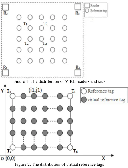
‘Virtual Reference Elimination’ (VIRE) is introduced in [6]. In the VIRE, instead of deploying many real reference RFID tags, the concept of virtual reference tags is provided as denser reference coverage in the sensing areas.
The distribution of VIRE reader
R
iand reference tags,Ta,b
T, Tc and Td are shown in Figure 1 with relationship, +
∈N
d c, b,
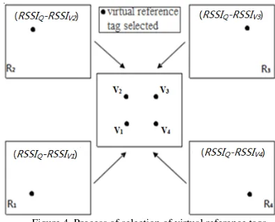
a, . The object tags are in the range of specified area. The core of VIRE method is related to 4 reference tags as a unit grid: N1xN1, shown in Figure 2.
Figure 1. The distribution of VIRE readers and tags
Figure 2. The distribution of virtual reference tags
Under the condition of known values of reference tags’ position and density, the field strength of virtual reference tags in both horizontal and vertical directions is calculated by (2) and (3):
1 Ri Ri
Ri Ri
) , ( ) , 1 ( )
, ( ) , (
N
b a E b N a E t b a E b t
E = + × + − (2)
1 Ri Ri
) , ( ) 1 , ( )
, ( ) , (
N
b a E N b a E u y a E y u
E Ri
Ri
− + ×
+
= (3)
wherein,
E
Ri is RSSI value of reference tag located atthe coordinate
(
i
,
j
)
for theR
i reader. The values ofparameters are
a
=
i
/
N
1
,b
=
j
/
N
1
, t is known and located at x axis as the interval of object virtual reference tag, and u is known and located at y axis as the interval of object virtual reference tag.Under the conditions of known values of the field intensity of reference tags and virtual reference tags, LANDMARC algorithm is normally used to select a certain threshold for solving the nearest reference tag weights, in order to obtain positioning results [10].
[image:3.595.53.288.116.215.2]Figure 3. The definition of virtual reference tags area
The positioning system is for a two-dimensional plane. The location area has a size of S×T, where reference tags are the four vertices of the region, and the coordinates are
T
1(
0
,
0
)
,T
2(
0
,
T
)
,T
3(
S
,
T
)
,T
4(
0
,
S
)
. Four readersare placed on those vertices, as shown in Figure 3.
Assuming the Coordinate of virtual reference tag D is (xi,
yj), the Euclidean distance between D and reference tags Ti are: 2 i 2 i y x
1 = +
PT
D
2
i 2
i y
-x
2 ( T)
DPT = +
2
i 2
i- y
-x
3 ( S) ( T)
DPT = + (4)
2
i 2
i- y
x
4 = ( S)+
DPT
According to above (4), the tables are established for the four reference tags shown in Table II below.
TABLE II. VIRTUAL REFERENCE TAGS RSSI FOR REFERENCE TAGS
Distance of virtual reference Tags to the reference tags
RSSI value of virtual reference Tags relative to the reference tags
1 PT D 1 PT RSSI 2 PT D 2 PT RSSI 3 PT D 3 PT RSSI 4 PT D 4 PT RSSI
There are
(
1
1
)
24
−
+
[image:4.595.318.515.103.262.2]N
data in the table.Figure 4. Process of selection of virtual reference tags
2)The selection of virtual tags
An object node is located atQ(xq,yq), the RSSI values
will be read by readers at four corners. A comparison was carried out with the virtual reference tags’RSSI from readers. The virtual reference tags that are nearest distance between
) , (xq yq
Q are selected according to the following algorism.
IF
RSSI
Q>0THEN
for i=1 to (N1+1)2 -4
do
i
V Q
i
RSSI
RSSI
Value
=
−
ELSE
Return (min Valuei)
Return i end
End
The four virtual reference tags are selected in Figure 4 as below.
)
,
(
1 11
x
vy
vV
,(
,
),
2 2
2
x
vy
vV
(
,
),
3 3
3
x
vy
vV
(
,
)
4 4 4
x
vy
vV
B. The realization of algorithm in VIRE system 1) Traditional centroid algorithm
According to the traditional centroid algorithm, the four virtual reference tags are selected to form an enclosed area that is the estimated area of the object node [12]. By (5), the estimate coordinates of object node can be calculated.
Figure 5. The schematic diagram of the renewed centroid algorithm
2) Renewed centroid algorithm
Through narrowing down the testing area, a key improvement of centroid algorithm in positioning accuracy is described as follows.
According to the geometric relationship, in Figure 5, the coordinates: e, f, g, h, and o, are defined in the following relationships of (6), (7), (8), (9) and (10):
)
(
2
1
)
(
2
1
3 2 3 2 v v e v v ey
y
y
x
x
x
+
=
+
=
(6))
(
2
1
)
(
2
1
2 1 2 1 v v f v v fy
y
y
x
x
x
+
=
+
=
(7))
(
2
1
)
(
2
1
4 3 4 3 v v e v v gy
y
y
x
x
x
+
=
+
=
(8))
(
2
1
)
(
2
1
4 1 4 1 v v h v v hy
y
y
x
x
x
+
=
+
=
(9))
(
4
1
)
(
4
1
4 3 2 1 4 3 2 1 v v v v o v v v v oy
y
y
y
y
x
x
x
x
x
+
+
+
=
+
+
+
=
(10) [image:5.595.78.271.99.264.2]The process of the renewed algorithm is as shown in Table III.
IV. THE SIMULATION AND ERROR ANALYSIS
In the simulation experiment, Matlab7.6.0 software is used. There are two indicators of size set up and the positioning accuracy is set as the evaluation criteria, when the positioning precision, scale, network coverage rate, and power consumption are often used as the evaluation index in the WSN. In the simulation experiment, the WSN area is set that the S and T are equal to 90. The reference tags are located at the four vertices of this area and uniformly
distributed. The positioning error of the object nodes is defined in (11):
1
2 real q 2 real q
s
) y -(y ) x -(x or
AverageErr = + (11)
Wherein, s1 is the times of the Simulation.
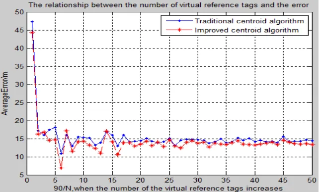
A. Searching the optimum number of the virtual reference tags
[image:6.595.70.544.240.342.2]As shown in Table IV, ten object nodes’ RSSI are from the reader
R
i , where i is shown as 1, 2, 3, 4.TABLE IV OBJECT NODES’S RSSI
[image:6.595.138.459.415.609.2]When the number of the virtual reference tags increases, the error in comparison with the two algorithms are illustrated in Figures 6 and 7.
Figure 6 shows that there is no obvious change between the two algorithms, if the number of the virtual reference
tags is above 121 and the 90/N2 is greater than 10. The best performance shows that the number of the virtual reference tags is 49 when 90/N2 is equal to 6. It follows that the renewed centroid algorithm could further improve the accuracy compared with the traditional centroid algorithm.
Figure 7. The error comparison of two algorithms when the number of the virtual reference tags increases
B. Comparison of the two algorithms when the number of virtual reference tags is 49
Figure 8 shows that the results are obtained by (5) from the test for 100 times. It is clear that the renewed centroid
[image:7.595.146.451.102.302.2]algorithm gets a further improved localization accuracy compared with the traditional one.
Figure 8. The comparison of the two algorithms
C. Error analysis
For the virtual reference tags, they may not be able to choose four ones near the object node, or four virtual reference tags are repeatedly chosen, as it may lead to excessive error(s). In the radio propagation model, the signal is disturbed by the external environment instead of being transmitted in free space. Through repeated measurements and the statistical average value, some error can be reduced, although the further improvement is still needed.
V. CONCLUSION AND FUTURE WORK
A. Achievements
[image:7.595.108.491.370.602.2]B. Future work
However, there are still some shortcomings existing in the positioning methods. On one hand, the signal propagation model applicable to non-free-space conditions needs further research. On the other hand, the selection methods of the virtual reference tags need further optimization so as to further improve the positioning accuracy.
Acknowledgement: authors thank Dr Sawsaa’s feedback and proof reading for the final version of the paper.
REFERENCES
[1] S. K. Low, H. A. Nguyen, and H. Guo, Optimization of sensor node locations in a WSN[C]//Fourth International Conference on Natural Computation. 2008, pp. 286-290. [2] G. Mao, B. Fidan, and B. D. O. Anderson, “Wireless
sensor network localization techniques,” Comput. Netw., vol. 51, pp. 2529–2553, 2007.
[3] C. Liu, H. Jiang, and D. Wang, Range-based node localization algorithm for wireless sensor network using Unitary Matrix pencil[C]//Test and Measurement, 2009, ICTM'09, International Conference on. IEEE, 2009, vol. 2, pp. 128-132.
[4] N. Bulusu, J. Heidemann, and D. Estrin, GPS-less low-cost outdoor localization for very small devices [J], Personal Communications, IEEE, 2000, vol. 7(5), pp. 28-34.
[5] D. Moore, J. Leonard, and D. Rus, Robust Distributed Network Localization with Noisy Range Measurements[C]. Proceedings of the 2nd International Conference on Embedded Networked Sensor Systems, Baltimore, USA, 2004: 50-61.
[6] Z. Yiyang and L. Yunhao, VIRE: Active RFID-based localization using virtual reference elimination[C], XiAn, 2007 International Conference on Parallel Processing, 2007, pp. 56-63.
[7] M. Srivastava, D. Culler, and D. Estrin, Guest editors' introduction: overview of sensor networks [J], Computer, 2004, vol. 37(8), pp. 41-49.
[8] L. Girod, V. Bychovskiy, J. Elson, and D. Estrin, Locating Tiny Sensors in Time and Space: A Case Study, [C]//Proceedings of the 2002 IEEE International
Conference on Computer Design: VLSI in Computers and Processors. Freiburg, IEEE, 2002, pp. 214-219. [9] M. N. Lionel, Y. H. Liu, and Y. C. Lau, LANDMARC:
Indoor location sensing using active RFID [J], Wireless Networks, 2004, vol. 10(6), pp. 70l-7l0.
[10]W. Shi, L. Liu, Y. Ju, G. Yan, and G. An Efficient Indoor Location Algorithm Based on RFID Technology, [C]//Wireless Communications Networking and Mobile Computing (WiCOM), 2010 6th International Conference on. IEEE, 2010, pp. 1-5.
[11]J. Caffery, A new approach to the geometry of TOA location [C]//IEEE VTC2000 Fall September 24—28,
Boston, USA, 2000, pp. 1943—1949.
[12]J. Yoon, J W. Kim, W. Y. Lee, and D. S. Eom, A TDOA-based localization using precise time-synchronization[C], Advanced Communication Technology (ICACT), 2012 14th International Conference on, IEEE, 2012, pp. 1266-1271.
[13]J. Zhou, H. Zhang, and L. Mo, Two-dimension localization of passive RFID tags using AOA estimation, [C]//Instrumentation and Measurement Technology Conference (I2MTC), 2011 IEEE, 2011, pp. 1-5. [14]L.M. Sun, J.Z. Li, and Y. Chen, WSNs [M], Tsinghua
University Press, 2005, pp. 135-155.
[15]H. Shi, A new weighted centroid localization algorithm based on RSSI, [C]//Information and Automation (ICIA), 2012 International Conference on. IEEE, 2012, pp. 137-141.
[16]N. Saiedeh and O. M. Razavi, GPS-less indoor construction location sensing, original research article, Automation in Construction, vol. 28, December 2012, pp. 128-136
[17]X. Guangzhen, P. Yang, and L. He, Estimation of diffraction effect in ultrasonic attenuation by through-transmission substitution technique, original research article, Ultrasonics, April 2013, vol. 53, Issue 4, pp. 825-830
[18]M. Dakkak, A. Nakib, B. Daachi, P. Siarry, and J. Lemoine, Indoor localization method based on RTT and AOA using coordinates clustering, original research article, Computer Networks, 1 June 2011, vol. 55, Issue 8, pp. 1794-1803