Patron: Her Majesty The Queen Rothamsted Research Harpenden, Herts, AL5 2JQ
Telephone: +44 (0)1582 763133 Web: http://www.rothamsted.ac.uk/
Rothamsted Research is a Company Limited by Guarantee Registered Office: as above. Registered in England No. 2393175. Registered Charity No. 802038. VAT No. 197 4201 51.
Rothamsted Repository Download
A - Papers appearing in refereed journals
Catt, J. A. and Staines, S. J. 1982. Loess in Cornwall. Proceedings of the
Ussher Society. 5 (3), pp. 368-375.
The output can be accessed at:
https://repository.rothamsted.ac.uk/item/96xvx/loess-in-cornwall
.
© Please contact [email protected] for copyright queries.
Read at the Annual Conference of the Ussher Society, January 1982
Loess in Cornwall
J.A. CATT S.J. STAINES
J.A. Catt and S.J. Staines, 1982. Loess in Cornwall. Proc. Ussher Soc., 5, 368-375.
The distribution of Late Devensian loess in Cornwall and the Scilly Isles is described. Many Cornish soils are silty, but only some of them contain appreciable amounts of loess; others are derived mainly from slates, Detailed particle size analyses and the mineralogical composition of coarse silt fractions of the loess-containing horizons show that it differs from Late Devensian loess in east Devon and other parts of southern England, but probably contains only a little locally-derived aeolian sediment. Most of it was probably blown from glacial outwash deposits in the southern part of the Irish Sea basin.
J..A. Catt, S.J. Staines, Soil and Plant Nutrition Dept. and Soil Survey of England and Wales, Rothamsted Experimental Station, Harpenden, Herts AL5 2JQ.
Introduction
During the last 2-3 decades soil mapping and research on soil parent materials has demonstrated that thin deposits of windblown silt (loess) are widespread in south and east England (Catt, 1978). In Cornwall they were originally recognised by Coombe et al. (1956) on the Lizard
peninsula, where they give rise to stagnogley soils (Avery, 1980) characterised by "Short Heath" plant communities
(Agrostis setacea heath). These contrast with the less acid
“Tall Heath” (Erica vagans - Schoenus heath), "Rock
Heath" (Festuca ovina - Calluna heath) and "Mixed
Heath" (Erica vagans Ulex europaeus heath) communities
on soils derived mainly from the serpentine. Further interest in these deposits has recently been aroused by Wintle (1981), who used thermoluminescence techniques to obtain Late Devensian dates for samples from the Lizard, the Scilly Isles and other sites in southern England.
Where loess is thick and in part unweathered, as in some areas of south-east England and many European and Asian countries, it is usually an unbedded pale yellowish brown calcareous silt, sometimes with terrestrial molluscs and carbonate nodules. The particle size distribution (10-15% clay, <10% sand, and a modal silt size in the 20-60µm range) is quite characteristic. However, in areas where the deposit is thin (<lm) and weathered throughout, it is often non-calcareous and more variable in colour and clay content. Thin layers are also prone to disturbance, erosion and reworking, so that mixing with other materials may further modify the colour and particle size distribution. The loess component in such mixed, weathered deposits, which are often equivalent to the topsoil and various subsoil horizons, is then identifiable only by the presence of a small mode in the 20-60µm range and a characteristic mineral assemblage in the same size range. In many parts of south and east England, loess deposited during the
Late Devensian has a silt mineral suite related to glacial deposits of the same age in Yorkshire, Lincolnshire and Norfolk (Catt et al. 1974, Catt 1978), and beyond the ice
limit this assemblage distinguishes the loessial silt from silt of other provenance.
Harrod et al. (1973) reported thin loess over various
substrata (granite, Devonian limestone, Budleigh Salterton Pebble Beds, Clay-with-flints-and-cherts, and the Haldon Gravels) in east Devon, and equated the deposit with the Late Devensian loess further east. However, compared with the loess in eastern England and the Midlands, the Devon deposits are composed of finer silt that is rich in flaky minerals, a difference which Harrod et al. attributed to the winnowing effect of
predominantly north-easterly periglacial winds responsible for deposition of the loess. This agreed with the suggest source in glacial outwash deposits in eastern England and on the floor of the North Sea, which would have been dry during the Late Devensian because of the eustatic fall of sea-level. However, it is unlikely that the North Sea basin could have provided all the loess of western Britain and northern France. From their mineralogical studies, Coombe et al. concluded that the Lizard loess was derived
largely from nearby Hercynian granites, but it is also possible that Devensian outwash deposits in western Britain (e.g. in the Irish Sea basin) provided some of the loess in western areas.
could provide abundant silt-sized material. We therefore examined the detailed particle size distribution and silt mineralogy of some of the more silty soils to determine the distribution of Cornish loess more precisely, and also to compare it with the similarly analysed loess from other parts of southern England.
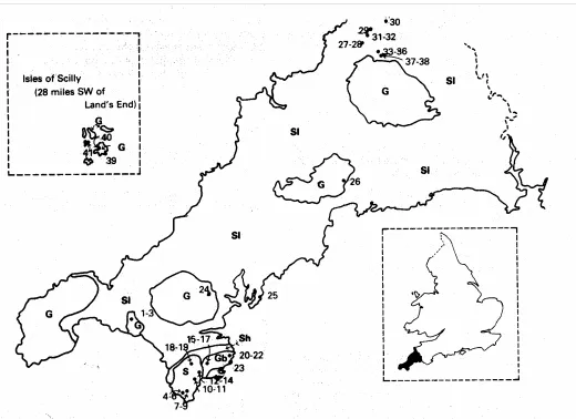
Location of samples
Silty horizons were examined from soils over various rock types on the Lizard peninsula (Ordnance Survey 1:25,000 sheets SW61, SW71, SW72, SW81 and SW82), and in the Hayle (SW53), Penryn (SW73), Falmouth (SW83), St Austell (SX05) and Camelford (SX18) areas, as follows:
1-3. Humic brown podzolic soil (variant of Moor Gate series) at 128m OD on granite at Godolphin Warren (SW 595310); Ah (8-29cm), Bs (29-49cm) and BC (49-85cm) horizons (Staines, 1979, pp.112-3).
4-6. Typical stagnogley soil (Croft Pascoe series) at 80m OD on serpentine of the Lizard plateau, under "Short Heath" vegetation (SW 686150); Ah (2-17cm), Bsg (17-26cm) and Btg (26-71cm) horizons.
7-9. Cambic gley soil (Traboe series) at 76m OD on serpentine of the Lizard plateau, under “Mixed Heath” vegetation (SW 690152); E (16-30cm), 2Bg2 (55-103cm) and 2BCgl (103-126cm) horizons.
10 and 11. Cambic gley soil (Eglos series) at 75m OD on granite-gneiss with serpentine on Lizard plateau (SW 708168); Ap (0-17cm) and Bg (17-29cm) horizons.
12-14.Stagnogleyic argillic brown earth (Gwavas series) at 67m OD on granite-gneiss with serpentine on spur of dissected Lizard plateau (SW 719155), Bw (25-53cm), Bt(g) (95-115cm) and 2BCg (132-150cra) horizons.
15-17: Argillic brown earth (variant of Trusham series) at 94m OD on gabbro, Goonhilly Downs (SW 753195); Eb (27-53cm), Bt(g) (72-124cm) and C (144-176cm) horizons.
18 and 19. Cambic gley soil (Traboe series) at 100m OD on serpentine in shallow valley on Lizard peninsula (SW 732204); Ah (5-13cm) and BCg (67-95cm) horizons.
20-22. Typical brown earth (Lesneague series) at 64m OD on hornblende schist on upper valley side above Porthoustock Cove (SW 805220); Ap (0-12cra), Bw2 (32-76cm) and BC (76-120cm) horizons.
23. Typical brown earth (variant of Gwavas series) at 4m OD over raised beach gravels at Lowland Point (SW 803195), Lizard; C horizon (210-220cm). Flint flakes found in the surface horizon near this site were probably Mesolithic.
24. Typical brown podzolic soil (Moretonhampstead series) at 100m OD on granite head at Burnthouse, near Penryn (SW 766369); Bs horizon (40-60cm).
25. Stagnogleyic brown earth at 10m OD on slaty head at Towan Beach (SW 873332) on west side of Gerrans Bay; BC horizons (110-120cm) in frost wedge penetrating head.
26. Typical brown podzolic soil (Moretonhampstead series) at 120m OD on granite head at Great Prideaux, near Luxulyan (SX
057559); Bs horizon (35-65cm).
27 and 28. Typical brown earth (Highweek series, deep phase) at 240m OD on Upper Devonian slates (SX 101858); Bwl (10-25cm) and BC 1 (45-57cm) horizons (Staines, 1976, pp.34-5). 29. Typical brown earth (Highweek series, deep phase) at 260m OD on Lower Carboniferous slates (SX 119887); Bw horizon (30-59cm) (Staines, 1976, pp.36-7).
30. Typical brown earth (Highweek series) at 230m OD on Lower Carboniferous slates (SX 199884); Bw horizon (12-30cra) (Staines, 1976, pp.35-6).
31 and 32. Gleyic brown earth (Ivybridge series) at 260m OD on Upper Carboniferous slates (SX I 11879); Bwl (10-29cra) and Bg (41-90cm) horizons (Staines, 1976, pp.40-1).
33-36. Ferric stagnopodzol (Hafren series) at 290m OD on Upper Devonian slates (SX 155850); Eg (8-15cm), Bsg (15-28cm), BC1 (28-44cm) and BC2 (44-80cm) horizons (Staines, 1976, pp.57-8).
37 and 38. Ironpan stagnopodzol (Hiraethog series) at 295m OD on Upper Devonian slates (SX 158838); Bsl (15-24cm)and Bs2 (24-39cm) horizons (Staines, 1976, pp.59-61.
The soil classes and horizon nomenclature used are from Avery (1980). In addition three samples from the Scilly Isles were studied: sample 39 was from Heliport Cliff, St Mary's (SV 918101), sample 40 from Porthloo, St Mary's (SV 907115), and sample 41 (kindly donated by Dr A.J. Sutcliffe of the British Museum, Natural History) from East Porth, Sampson (SV 878128). Figure 1 shows the location of all samples.
Analytical methods
Samples were air-dried and gently ground to pass a 2mm mesh, which retained stones >2mm. Particle size analysis at ø intervals (ø = -log2 grain size in mm) was determined by sieving and the
pipette sampling technique after peroxidation to remove organic matter and dispersion by overnight shaking in a dilute solution of sodium hexametaphosphate. Coarse silt fractions (4-6 ø, 63-16 µm) were then separated from the same aqueous suspension by repeated settling under gravity. Each was divided into light and heavy minerals by centrifuging in bromoform (specific gravity 2.9 approximately), and analysed mineralogically with a polarising microscope. Other analytical techniques are those described by Avery and Bascomb (1974).
Results
Particle size distribution
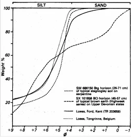
The total silt (4-9 ø, 62-21µm) contents of the 41 samples analysed ranged from 37.7 to 87.4% by weight (oven-dry basis). Six samples, all from the Lizard area, contained >75% silt (samples 4, 5 and 6 from the Croft Pascoe series on serpentine under "Short Heath", sample 7 from the E horizon of the Traboe series on serpentine under "Mixed Heath", sample 13 from the Bt(g) horizon of the Gwavas series on granite-gneiss, and sample 23 from the variant of the Gwavas series on raised beach gravels at Lowland Point), and in each of these the modal size is the 4-5 ø range (usually about 40-44µm), and clay content greatly exceeds sand. In these respects the samples resemble loess from Kent, Belgium (Fig 2), and many other parts of the world.
Sixteen of the samples contained between 60 and 75% silt, and in all but one of these the amounts of clay were <25%, which is approximately the upper limit of clay content in soil horizons derived solely from loess. However, the percentages of sand in these samples ranged from 6.5 to 33.1, which often exceed the amounts normally found in loess. Also, although ten of the sixteen had a modal size in the 4-5 ø range, the others had considerably finer silt modes. It is therefore unlikely that any of these samples are purely loessial in origin; some may contain a little loess, but this is probably mixed with sand from other sources.
The remaining nineteen samples, with silt contents 60%, contained even more sand (up to 50.4%), but no more clay (2.4-29.6%). Eight of these samples had modes in the 4-5 ø silt range, and may contain a little loess. However, in the other eleven the mode was finer (usually in the 7-8 ø, 8-4 m, range) and poorly defined, the silt being spread almost evenly over the five ø units (Fig. 2). These samples are unlikely to contain any loess; as many were from soils on slates, such as the Highweek (samples 27-30), Hafren (samples 35 and 36) and Hiraethog (sample 38) profiles, they are probably composed of weathered slate.
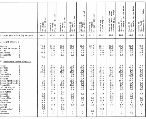
Coarse silt mineralogy
Table 1 gives the mineralogical composition of coarse silt fractions from six of the most silty samples from the Lizard area, all of which have strong modes in the 4-5 ø range, and also of three samples from the Scilly Isles. In the Lizard samples the amounts of quartz, alkali feldspar, flint, muscovite, glauconite, epidote and zoisite are fairly constant; muscovite and glauconite are less common in sample 4, but this is probably because of weathering, as the sample was taken very Close to the surface. In contrast, the other heavy minerals (principally zircon, tourmaline, chlorite, green hornblende, tremolite, yellow rutile and garnet) are more variable in amount. As Coombe et al. (1956) pointed out, some of the heavy
minerals in the Lizard loess could be derived from local bedrock formations, so the range in amounts of some minerals may reflect local fluctuations in supply of silt from these sources. Coombe et al. recorded epidote in only one of the samples they analysed, but we identified it as a major constituent of the non-opaque heavy fraction of the 4-6 ø silt. They also reported apatite, topaz and bowlingite (fibrous saponite formed by alteration of olivine), which we failed to identify. These analytical inconsistencies may result partly from the different size limits of the fractions analysed (Coombe et al. found these minerals in the 20-200µm fraction, whereas we analysed the 16-63µm fraction only), but they may also indicate further local variation in the mineralogy of the loess.
Compared with the loess in east Devon described by Harrod et al. (1973), the Lizard samples generally have
more silt-sized epidote, zoisite, zircon, green hornblende, tremolite, rutile, garnet and spinel, but less glauconite, chlorite and biotite (Table 1). The two assemblages are otherwise similar, but neither the westward increase in flaky minerals nor the westward decrease in modal particle size noticed in the loess of south-east England (Harrod et al. 1973; Catt, 1978) is continued into
Cornwall. The incorporation of local silt minerals in the Cornish loess could have decreased the proportion of flaky minerals, but is unlikely to have changed the particle size distribution of the whole deposit sufficiently to move the mode from 26µm, a (the value for loess on Dartmoor and near Torquay) to 40-44µm. The Lizard loess has recently been dated as Late Devensian, the same age as that in east Kent (Wintle, 1981), so the mineralogical and textural differences cannot result from
deposition at different times. Instead they suggest that the Cornish loess was mainly derived from a different source (and possibly a different direction) from the loess in east Devon and other parts of southern England.
Of the three samples from the Scilly Isles, two (40 and 4 I) are similar to the Lizard loess in both silt mineralogy (Table I) and particle size distribution. However, the third (sample 39) is much coarser, with a modal size of 60-65µm, and contains less alkali feldspar but more quartz in its 16-63µm fraction. This suggests that it contains only a small proportion (probably <50%) of loess, which has been mixed with a quartz-rich but feldspar-poor silty fine sand. This second component is unlikely to be derived from local granitic bedrock, which Would yield much feldspar, and is also unlike any of the head or glacial deposits on the islands described by Mitchell and Orme (1967). Its source is therefore unknown, but probably lies outside the islands; this implies that, like the loessial silt component, it was brought by the wind.
Despite some variation in the silt mineral assemblages and possible incorporation of material from Cornish bedrocks, most of the coarse silt cannot be derived from the rocks on which the deposit rests. As Coombe et al.
(1956) noted, the abundance of quartz, alkali feldspar and some other minerals indicates that the loess of the Lizard is completely unrelated to the serpentine beneath. The mineralogical and particle size similarity of the silt in diverse physiographic situations as far apart as the Lizard and Scilly Isles can only be explained by long distance aeolian transportation. Although it is true that some of the characteristic minerals could have come from the Hercynian granites, there are many other possible sources for them, and the flint, glauconite and microcline (which is a common type of alkali feldspar in all the samples) are certainly from elsewhere. It is unlikely that physical weathering of granite, even by continued frost shattering in periglacial conditions, would produce much silt. As with loess in many other parts of the world, it is therefore more likely that most of the silt was derived from a more distant source than the local Hercynian granite outcrops, for example from glacial outwash on the floor of the Irish Sea.
Distribution of loess in Cornwall and Scilly Isles
Soil samples with a coarse silt quartz: feldspar ratio of 8:1 or less (as in the Lizard samples, Table 1) contain 100% loessial coarse silt, ones with a quartz: feldspar ratio of 16:1contain approximately 50%, ones with a ratio of 32:1 contain only 25%, etc. The minimum percentage of 16-63µm silt in any of the pure loesses is about 50, so the maximum loess content of a mixed sample is no more than twice the amount of loessial coarse silt inferred from the quartz: feldspar ratio. Another reason why the loess percentages should be taken as maxima is that the calculation is based on the assumption that any coarse silt of non-loessial origin contributes quartz but no feldspar. This is never completely true, though we believe that the amounts of feldspar in slates and other Cornish pre-Devensian deposits are small enough to prevent us over-estimating loess contents by more than about 10%. Examination of the heavy silt mineral assemblages provided an additional check on the presence of loess in the samples, but as the slates or other non-loessial silts may have introduced no new heavy minerals, the heavy minerals could not be used alone to calculate loess contents.
Table 2 gives the amounts of loess calculated in this way for each of the 41 samples analysed. This shows that, with the exception of samples 23 and 25, the most loess-rich soils are confined to sites on granite, granite-gneiss and serpentine. At Towan Beach (sample 25) the loess-containing material is confined to a narrow frost-wedge penetrating the upper layers of a thick slaty head, which in turn overlies slates of the (?)Devonian Portscatho Series. Other soils on slates contain no more than 20% loess. The relatively thick loess at Lowland Point (sample 23) seems to be restricted to a small area occupied by the raised beach, which in turn rests on gabbro-troctolite. At the other site on gabbro (Goonhilly Downs), less than half the top 50cm only of the soil is composed of loess.
Among the samples with large or moderate (>35%) amounts of loess, all but two have modes in the 4-5 ø range (Table 2), whereas all but four of the samples with <30% loess have modes in size fractions other than 4-5 ø. Therefore, although particle size analysis at ø intervals is a fairly satisfactory means of identifying the loess, even when it is mixed with other material, some samples
Table 2. Loess contents of silty soils in Cornwall and the Isles of Scilly, based on amounts of coarse silt (4-6 ø, 63-16µm and the quartz/feldspar ratio in this fraction.
incorporating other silty or fine sandy components may contain as much as 40% loess without showing the characteristic coarse silt mode.
Combining the information in Table 2 with field observations made during the recent 1:250,000 soil survey of Cornwall and during 1:25,000 surveys of the Camelford, Hayle and Lizard districts (Staines, 1976, 1979, in press), it is possible to show the occurrence of loess throughout the county with some confidence (Fig. 1). Although many soils on the Devonian and Carboniferous slates are very silty, the results shown in Table 2suggest that only a little of this is loessial in origin. Most was probably derived from weathering of the slates. The only field evidence for loess on the slates is the occasional random occurrence of local stoneless silty subsoil layers, which mainly occur in south Cornwall, and the silt-filled wedge at Towan Beach. If a more
continuous layer of loess originally covered these rocks, most of it has been removed by erosion. However, there is little evidence inland of reworked loess on footslopes or in valley and basin sites.
often preferentially deposited on the lee side of obstacles. On the Scilly Isles the loess-rich silt loam horizons are confined to flat, relatively sheltered sites where there is little evidence of reworking. The deposit here generally overlies the main granite head, and shows only minor disturbance near the surface, where thin stony layers often occur. This suggests the loess was deposited here after the last main phase of gelifluction, and that is subsequently suffered little erosion.
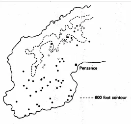
Figure 3. Sites on the Lands End peninsula where loess-rich loam horizons (closed circles) and less silty loessial horizons (open circles) were identified during soil mapping.
The most continuous loess deposits in Cornwall occur on the Lizard peninsula, where they are again mainly confined to the fiat planation surfaces. The thickest deposits (usually 0.5-1.5m, but locally up to 2.5m) are on the serpentine outcrop, where they form a nearly continuous mantle. There is little evidence of mixing with serpentine-derived material except on sloping sites near streams. Deposits on the gabbro and granite gneiss are generally thinner and less continuous.
Discussion and Conclusions
The different modal particle size and heavy silt minerals of the Late Devensian loess in Cornwall and the Scilly Isles compared with that elsewhere in southern England suggest the two are derived at least partly from different sources. As Coombe et al. (1956) noted, some of the silt
minerals in the Cornish loess could come from local igneous rocks, such as the Hercynian granites, and the slight mineralogical variation of the loess from site to site could then be explained by irregular incorporation of locally derived aeolian material. However, it is unlikely
Table 3. Proportion of soils assessed to have loessial additions on the Cornish Hercynian Granites (observations made during 1:250,000 soil survey of Cornwall).
%of soils % soils Total No
with with one of obser-
minor or more vations
accumu- stoneless
lations of silt
silt loam horizons
Scilly Isles 3 61 72 Lands End Granite 10 12 339 Carnmenellis/Godolphin
Granite 14 4 330 St Austell Granite 16 0 113
that more than a few per cent of the silt came from local rocks. As in eastern England (Cart 1978) and many other parts of the world, most of the loess in Cornwall and the Scilly Isles was probably derived from glacial outwash deposits. The most likely area of extensive Late Devensian outwash deposits that could have supplied loess to Cornwall was in the Irish Sea basin. The concentration of the loess in southern parts of Cornwall in the lee of higher ground, particularly on the Lands End peninsula, agrees with derivation from this direction (i.e. from N-NW), but mineralogical comparisons with Devensian glacial deposits in the Irish Sea area have yet to be made.
However, aeolian deposition in the lee of obstacles, such as the scarp-like hills of northern Penwith, does not account entirely for the observed distribution of loess in Cornwall. As in the Midlands and northern England (Catt, 1978), there is a definite correlation with bedrock type, the Cornish loess residing preferentially on serpentine and to a lesser extent on granites and gabbros, but hardly at all on schists and slates. Originally it must have been deposited more evenly than this, implying that the surfaces of some bedrock types were contemporaneously or subsequently subject to more intensive erosion than others. As the most continuous loess remnants occur on flat plateaux, and intervening slopes are often devoid of loess, the erosion must have been principally by mass movement on slopes.
(stream length per unit area), estimated from large scale Ordnance Survey maps, is approximately 1.5 times greater in areas of slate bedrock than on serpentine and granite, so late Flandrian removal of material could have been slightly more rapid from the slate areas. However, most Neolithic and Bronze Age occupation sites in Cornwall occur on the granites, on the Lizard peninsula and in some coastal areas. It is only since the Iron Age that slate areas have been extensively settled, and even then the extent of cultivation was much less than in eastern England.This suggests that late Flandrian colluviation was less
important than Devensian gelifluction in removing loess from the slate areas.
The ?Mesolithic flints in upper horizons of the loess profile at Lowland Point suggest that deposition here had ceased long before the late Flandrian. Patches of similar raised beach capped by loess and other aeolian sediments, often with an intervening head deposit, are common along the south Cornish coast (James, 1968, 1975) and on the Scilly Isles. However, most of the loess in such sites is either the original wind-deposited sediment or penecontemporaneously geliflucted material from nearby coastal slopes. It is not relevant to the problem of loess distribution inland, as loess eroded from the widespread slate outcrops should now occur mainly in marine and estuarine sediments well below present low tide level.
From the thickness and distribution of head deposits in Devon, Waters (1971) concluded that gelifluction removed material more efficiently from slate and sandstone outcrops than from the Dartmoor granite. This is probably because in periglacial areas ground ice accumulates more readily, and closer to the surface, in fine grained materials, including shales, than in much coarser sediments or massive bedrock (Zoltai and Pettapiece, 1973). As most of the loess on the Cornish granites and serpentine occurs on flat surfaces as a fairly distinct layer above the head deposits, there was less cryoturbation in such situations during or after loess deposition than on the shales, where any remaining loess is preserved in wedges or incorporated into patches of head. As in Devon, this implies less ground ice on massive bedrock like granite and serpentine, and consequently less gelifluction. The preferential removal of loess from Cornish slate areas thus probably dates mainly from the Late Devensian.
Acknowledgements. We thank H.C.L. James for directing us to
several important sites, and E.M. Thomson for drawing the diagrams.
References
Avery, B.W. 1980. Soil Classification for England and Wales (Higher Categories). Soil Surv. Tech. Monograph 14, 67pp.
Avery, B.W. and Bascomb, C.L. 1974. Soil Survey Laboratory Methods. Soil Survey Technical Monograph 6, 83pp.
Catt, J.A. 1978. The contribution of loess to soils in lowland Britain. pp. 12-20 In: J.G. Evans and S. Limbrey (eds.) The Effect on the Landscape: the Lowland Zone. Council for
British Archaeology Research Report 21.
Catt, J.A., Weir, A.H. and Madgett, P.A. 1974. The loess of eastern Yorkshire and Lincolnshire. Proc. Yorks. Geol. Soc. 40, 23-39.
Coombe, D.E, Frost, L.C., Le Bas, M. and Watters, W. 1956. The nature and origin of the soils over the Cornish serpentine.
J. Ecol. 44, 605-615.
Harrod, T.R., Catt, J.A. and Weir, A,H. 1973. Loess in Devon.
Proc. Ussher Soc. 2, 554-564.
James, H.C.L. 1968. Aspects of the raised beaches of south Cornwall. Proc. Ussher Soc. 2, 55-56.
James, H.C.L. 1975. A Pleistocene section at Gunwalloe fishing cove, Lizard Peninsula. Proc. Ussher Soc. 3, 294-298.
Mitchell, G.F. and Orme, A.R. 1967. The Pleistocene deposits of the Isles of Scilly. Quart. J. Geol. Soc. Lond. 123, 59-92.
Staines, S.J. 1976. Soils in Cornwall I Sheet SX 18 (Camelford).
Soil Survey Record 34, 148pp.
Staines, S.J. 1979. Soils in Cornwall II Sheet SW 53 (Hayle).
Soil Survey Record 57, 198pp.
Waters, R.S. 1971. The significance of Quaternary events for the landform of south-west England. pp. 23-31 In: K.J. Gregory
and W.L.D. Ravenhill (eds.) Exeter Essays in Geography.
Univ. Exeter.
Wintle, A.G. 1981. Thermoluminescence dating of late Devensian loesses in southern England. Nature, Lond. 289,
479-480.