Evaluation of different global navigation satellite tracking
systems and analyses of movement patterns of cattle on alpine
pastures
Jan Maxa
*, Stefan Thurner, Georg Wendl
(Institute for Agricultural Engineering and Animal Husbandry, Bavarian State Research Center for Agriculture, Germany)
Abstract:Global Positioning Systems (GPS) as one of the Global Navigation Satellite Systems (GNSS) have been applied in many studies especially focusing on wildlife but there are very few studies using GPS on domesticated animals under extensive conditions combined with extreme relief such as in the Alps. Therefore, the main aim of this study was to test, evaluate and support the development of new tracking systems based on GNSS- and GSM- technology. Furthermore, movement patterns of cattle and the workload of herdsman were analysed for a possible optimization of the management of grazing animals in mountainous areas. Two newly developed prototypes of companies GNSS_L and GNSS_M and two commercially available systems GNSS_H and GNSS_T were tested on several alpine farms (AF) over the pasture season of the year 2012 and 2013. The evaluation of GNSS devices focused on position accuracy, battery life, smartphone applications as well as availability of supportive functions and application of geo-fencing. Also a standardized dynamic accuracy test of a GPS data logger and four different tracking systems was conducted. Movement pattern analyses focused on distances walked by cattle from sequenced GNSS fixes and autocorrelation of recorded information. Parallel to the previous aims the workload management of different alpine farms was analysed to support the evaluation of advantages of using GNSS tracking systems in mountainous areas. Based on the results of a comparison of the tested tracking systems we can conclude that devices GNSS_M and GNSS_T performed better under the alpine conditions compared with GNSS_L and GNSS_H, when GSM (Global System for Mobile Communications) reception was available. The standardized dynamic accuracy test showed significant differences (P≤0.001) among most of the tested GNSS collars and the GPS data logger, except between the prototypes GNSS_L and GNSS_M (P≥0.05). On average 62% of information on the distance walked by cattle was lost when GNSS fix intervals increased from 5 to 20 min. Finally, based on analyses of the workload of herdsmen this study showed potential of using GNSS tracking systems to reduce labour time requirement and workload for farming in mountainous regions.
Keywords:alpine agriculture, cattle movement, GNSS cattle tracking, position accuracy
Citation: Maxa, J., S. Thurner, and G. Wendl. 2015. Evaluation of different global navigation satellite tracking systems and analyses of movement patterns of cattle on alpine pastures. AgricEngInt: CIGR Journal , Special issue 2015: 18th World Congress of CIGR: 326-335.
1 Introduction
1Animal tracking based on various techniques has been
practiced since many decades. The study of Craighead
(1982) using radiocollars on grizzly bears can be
accounted as one of the pioneering studies in the area of
Received date: 2014-10-20 Accepted date: 2015-04-27 *Corresponding author: Jan Maxa, Institute for Agricultural Engineering and Animal Husbandry, Bavarian State Research Center for Agriculture, Voettinger Str. 36, 85354 Freising, Germany. Email: [email protected].
animal tracking. Since GPS can be used for civilian
purposes there have been numerous studies using GPS
mounted in neck collars on wildlife such as European roe
deer (Gottardi et al., 2010) and domesticated animals,
mainly cattle (Ungar et al., 2005) and sheep (Rutter et al.,
1997). However, studies focusing on using GPS to track
the cattle under extensive pasture conditions combined
with extreme mountainous relief (Thurner et al., 2011;
A decreasing number of livestock units grazed on the
alpine pastures during the last decades resulted in
abandoned land and succession processes in many
regions of the Alps (Ellmauer, 2005). Gfeller (2010)
mentioned high labour workload on AFs influenced by
fencing and daily check-up rounds looking for the
animals as one of the reason responsible for the
mentioned situation. In the study of Handler et al. (1999)
it was shown that on AFs with young cattle the labour
input for livestock control varied between 0.4 to 21.7
h/livestock unit and season and that the total workload
varied between 4.9 to 79.5 h/livestock unit and season.
The number of livestock units on AFs had an influence on
the total labour input, but only a weak influence on the
labour input for livestock control (Handler et al., 1999).
Nevertheless the relief of the farm and the area covered
with trees might have a higher influence on the labour
input for livestock control. Labour input needed for
livestock control and searching for livestock in the Alps
could be reduced via usage of modern technology such as
GNSS tracking combined with GSM data transfer
providing the actual location information of the animals
to herdsman.
With increasing number of used GNSS tracking
systems, the research on cattle behaviour is increasing as
well (e.g. Turner et al., 2000; Spink et al., 2013).
Furthermore, combinations of GNSS data with data from
other sensors like accelerometer and magnetometer were
used to develop cattle movement and behaviour models
(Guo et al., 2009). Looking at the utilization of tracking
systems by cattle grazed on AFs the information leading
to early recognition of lameness and heat can be of
advantage.
The main aim of this study was therefore to test,
evaluate and support the development of new tracking
systems based on GNSS- and GSM- technology.
Furthermore, movement patterns analyses focusing on
distances walked by cattle from sequenced GNSS fixes
and autocorrelation of recorded information were
analysed for further determination of cattle behaviour.
This will result in optimizing of the management of
grazing animals especially in the alpine areas of Europe.
Finally, the workload of different AFs was analysed to
access the evaluation of advantages of using GNSS
tracking systems in mountainous areas.
2 Materials and methods
2.1 Study sites
The study sites were situated in the alpine areas of
southern Germany (Bavaria) and western Austria (Tyrol)
and were chosen in order to cover various management
practices and differences in the environment and relief.
The total size of an AF including pasture and sparse
forest area varied between 250 and 1,130 ha. The average
altitude ranged from 1,077 to 1,613 m. The pasture period
in the studied areas usually covers the period from May
till October with great differences among the AF (six
weeks up to six months). The majority of the grazed
cattle were young heifers of Simmental breed with a
minimum number of heifers per AF of 37 and a
maximum of 180. The young cattle were ranged freely on
the pasture area without using stable facilities for the
whole pasture season on all except one AF. Overall,
fencing was very rare (close to dangerous places like
rocks and roads) which increased the need of application
of a cattle tracking system.
2.2 Workload analysis
Analysis of workload presented in this study was
evaluated on six and five AF during the pasture season
2012 and 2013, respectively.The total workload of the
herdsman was observed and daily manually registered for
32 activities divided into five main categories:
organisation, work-farm, work-stable, work-animal and
work-forest. The most important category work-animal
consisted of five activities such as: control, driving,
searching and recovering, treatment and other related
work with animals. Furthermore, every herdsman carried
one GPS data logger (type: Qstarz BT-Q1000XT,
VarioTek) adjusted to a GPS-fix position interval of one
altitude meters walked by the herdsman to control and
search the animals on the pasture and other related
activities.
The collected data were validated and analysed using
R software (version 2.15.2; http://www.R-project.org).
Descriptive statistics were computed for the amount of
observed and registered activities of the herdsmen as well
as daily and total distances and altitude meters
determined from GPS position data.The distance (D) in
meters between two successive GPS coordinates was
calculated according to the following Equation 1 (Kompf,
2014):
D = 6378.388 × arccos(sin(lat1) × sin(lat2) + cos(lat1) ×
cos(lat2) × cos(lon2 – lon1))/1000 (1)
Where: lat1 equals latitudinal degree of the location 1,
lat2 equals latitudinal degree of the location 2, lon1
equals longitudinal degree of the location 1 and lon2
equals longitudinal degree of the location 2.
2.3 Evaluation of GNSS cattle tracking systems
The new tracking system prototypes of two companies
GNSS_L and GNSS_M were tested together with two
other commercially available GNSS systems of
companies GNSS_H and GNSS_T on five and six AF
over the pasture season of the year 2012 and 2013,
respectively. The device’s brand name can be obtained by
requesting from the authors. Three of the tracking
systems have been specially developed for animal
tracking, while the fourth one has originally been used in
telematics branch. Devices GNSS_H were provided with
their own collars and housing which was located on the
bottom of the animal’s neck. The tracking system
GNSS_M used collars and housing of the company
Nedap without fixed position on the neck. For the other
two tracking systems GNSS_L and GNSS_T
commercially available collars with counterweight to
secure the optimal position of the housing on the top of
the cow’s neck were used (Figure 1). Tracking systems
GNSS_H and GNSS_L were rechargeable whereas
devices GNSS_M and GNSS_T used non-rechargeable
batteries to supply the energy for operation.
The involved cattle tracking systems were
tested un
der field conditions with focus on positionaccuracy, battery life, user-friendly service, website
and smartphone applications as well as availability of
other supportive functions such as measurement of
temperature of the animal, extreme behaviour and
application of geo-fencing. Furthermore, device
housing and collar type, way of data transfer, type of
satellite system and final costs of the tracking system
were compared.
The position accuracy measured as the standardized
dynamic accuracy of four tracking systems and the GPS
data logger mentioned in the previous chapter were
determined in 2013, using a rotating dynamic test
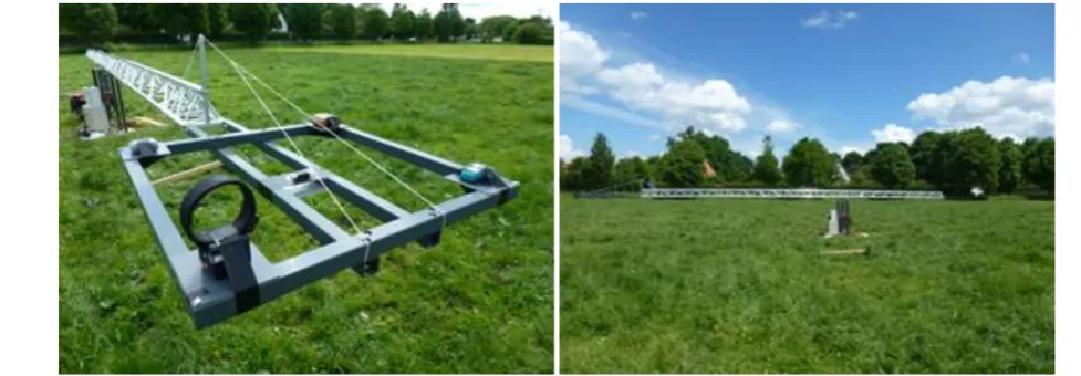
apparatus (Figure 2). The apparatus was built at the
experimental farm Grub of the Bavarian State Research
Center under open sky and level land. The data were
collected within the total test duration of four days and
the GPS collars were programmed to record positions
every 5 min. Data collection of at least 8 h daily was
considered in order to obtain at least one repetition of
ephemeris data download and retention described by
Augustine et al. (2011). Each of the tested tracking
system was placed at a pre-defined position at the end of
the apparatus’s arm (Figure 2) with a resulting radius
from 734 to 816 cm and 150 cm aboveground. The
position of four tracking systems changed based on the
test day but the GPS data logger was situated at the same,
middle position during the whole test period. The
distance between two tested tracking systems was at least
80 cm in order to minimize a possible influence of
tracking systems on each other. The average speed of the
rotational apparatus was approximately 5.65 km/h during
the whole testing period. Distances between collected
GNSS coordinates of all systems and the exactly
measured GNSS coordinates (± 1.31 cm) at the middle
point of the dynamic test apparatus were calculated using
the equation presented in equation from chapter 2.2
related to workload analysis. Datasets sent from the
tracking systems or saved by the GPS data logger
contained different type of information but the x and y
coordinates of the current position (coordinate system
WGS1984) and a time stamp were part of each dataset.
The accuracy of all systems was measured relative to the
known radius circle of the system at a certain test day.
The statistical differences in accuracy among the tested
GNSS tracking systems and the data logger were tested
with the Kruskal-Wallis-test and the
Wilcoxon-rank-sum-test using R software (version 2.15.2;
http://www.R-project.org).
2.4 Analysis of cattle movement patterns based on
GNSS data
Knowing the actual position of an animal on the
mountain pasture is one of the aims of the tracking
system based on GNSS and GSM technology.
Furthermore, categorizing of animal movements and
recognition of animal behavior such as lameness or heat
based on GNSS data are important features supporting the
utilization of such tracking systems.
In this study we focused on distance travelled by the
cow calculated from GNSS data based on different GNSS
time fix sampling intervals. Data for this analysis were
collected from six Simmental heifers which were tracked
every five minutes using GNSS_T collars during 18 days
in June and July 2013. The heifers were ranged freely at
least 14 hours per day on the AF situated in Tyrol,
Austria. Only days with at least 95% of transmitted
selected for further analyses. These criteria were met by
five out of 18 observation days and three out of six
devices. The obtained datasets were further subsampled
every 10, 20, 30, 60, 90, 120, 180, and 240 min. For each
heifer, day and subsampled dataset, the distance between
two successive GNSS fix positions were calculated.
When subsequent positions were missing, mean
coordinate values were calculated from the closest
records in the dataset. After that, the mean distances
travelled per hour in meters were calculated using the
equation from chapter 2.2. Furthermore, correlation
analyses were conducted for distances calculated between
pairs of sequential locations using Spearman correlation
in R software. The purpose of this calculation was to
obtain information on autocorrelation of the data which is
important for detailed animal movement analysis as
described in the study of Perotto-Baldivieso et al. (2012).
3 Results and discussion
3.1 Workload on studied alpine farms
As presented in Table 1, the observations of workload
on AFs pointed out that the category “work-animal” took
into account the major part of the total workload per day
at all, except for one AF. On the mentioned AF (AF 3),
58% of the total workload was used for the guest service
and the pasture area was relatively easy to overlook. The
activity “control of animals” on the pasture is one of the
most important areas for herdsman where GNSS tracking
systems could be applied. This activity accounted
between 6% to 90% of the total daily workload as shown
in Table 1. Compared to literature, Handler et al. (1999)
reported values from 11.5% to 57.8% of the total
workload on AF with young cattle for the activity
“control of animals”. The low amount of the activity “control of animals” on AF 4 can be explained by the
different management system compared to other
presented AFs. The heifers on AF 4 were driven every
morning to the stable where they stayed during the day.
This activity “driving animals” accounted for 63% of the
total daily workload on AF 4 and moreover incorporated
the activity “control of animals” as well.
As the next step of the workload analysis herdsman’s
daily and total distances and altitude meters needed to
control the animals on the pasture and other related
activities were estimated based on data from the GPS data
logger. So far no similar investigations have been
presented for the Alpine areas by other authors. As shown
in Table 1, the median of daily distances passed by
herdsman ranged from 2.7 to 9.0 km from AF4 to AF5,
respectively. Median of daily height differences passed
by herdsman are somewhat reflecting the topography of
the AF with a minimum of 426 m for AF 4 and a
maximum of 1,602 m for AF1 (Table 1). It was the
topography of AF which had the highest influence (R2 =
0.74) on the average workload in the category
“work-animal”.
The main aim of this study – to support the
development of new tracking systems based on GNSS-
and GSM- technology is aiming on optimization of
Table 1 Total workload and category with activities related to work with animals per alpine farm (AF) as
well as median of distance and height differences passed by herdsman on the alpine pasture
AF Total
workload
Category “work-animal”
Activity “control of
animals”
Median of distance
Median of height differences
No. h/d % of total
workload
% of total
workload km/d m/d
AF 1 8.2 67 24 8.5 1,602
AF 2 8.6 62 43 6.6 1,105
AF 3 6.6 29 22 4.8 432
AF 4 5.0 66 6 2.7 426
AF 5 4.7 99 90 9.0 1,446
management of grazing animals in European Alpine areas.
The results presented in this chapter showed high
workload and long distances needed to control the
animals by the herdsman. The main advantages when
tracking system has been applied in our study were:
reduction of time needed to control the animals on the
pasture, elimination of time spent to search lost animals
which can under special circumstances take the whole
day into account and better planning of the daily work
flow as a result of omission of unforeseeable tasks mainly
related to time spent to control and search the animals on
the pasture. Further described tracking system can be
used together with geo-fencing application for pastures
especially when fences are missing. Warning via e.g.
Short Message Service can be send to the herdsman when
animal with tracking system is entering an exclusion
pasture zone or dangerous area such as rocks. This
provides the herdsman advantage to briefly react and
drive the animals into desired direction. Furthermore, if
the movement data of the animals are stored in the
web-database, there is a possibility for earlier recognition
of un- or under grazed pasture areas based on
visualisation of such data. This could help to prevent
succession and degradation processes occurring in many
regions of the Alps and provide potential for optimization
of pasture management.
3.2 Performance and accuracy of GNSS cattle
tracking systems
Two newly developed tracking system prototypes
were compared with two other commercially available
GNSS systems over two pasture seasons during the year
2012 and 2013. The results of the comparison of all tested
tracking systems are summarized in Table 2.
Battery life is the most important criterion for using
tracking systems during the summer pasture period in the
Alps. Young cattle are usually grazed with a minimum
use of fencing systems, without stable facilities and the
possibility to fix the animal. Therefore, the tracking
system in such areas should be able to function at least
six months without the need of using a new set of
batteries or recharging the batteries. This is theoretically
fulfilled by most of the tested tracking systems except
GNSS_T, but none of the tracking systems reached the
full period of six months with GNSS position fixes every
20 min and sending the information via GSM or GPRS
Table 2 Comparison of four tested cattle tracking systems
Criteria GNSS_L GNSS_M GNSS_H GNSS_T
Battery life +/o +/o - o
User friendly service o + o/- +
Webpage + + - +/o
Smartphone-app o + - o
Supportive functions1
o +/o + o
Housing/Collar o + - +
Housing-Weight (g)2
550 250 665 (with collar) 220
Price Not known Not known - +/o
Transfer of data SMS SMS-GPRS SMS-GPRS GPRS
Data saving3
yes yes yes no
Satellite system GPS GPS-GLONASS GPS GPS
Accuracy information4 yes yes yes no
Note: 1 Alarm functions (geo-fencing, extreme behaviour and temperature), measurement of temperature of the animal, battery
status
2
weight of housing including batteries
3
Possibility to save the data in the tracking system in case of missing GSM/GPRS coverage
4
Information about the accuracy of the last position of the tracking system (in m) visible directly on the map of the website/smartphone app
(General Packet Radio Service) to the web-database
under practical conditions. Another very important test
criteria was the functionality. From the point of view of
functionality and user-friendly service of the tracking
systems, only two tracking systems, GNSS_M and
GNSS_T, were able to function during the whole pasture
period and give updated information about the position of
the animals on the pasture to the herdsman. Overall, the
receiver GNSS_T fulfilled best the criteria user-friendly
service. We can conclude that from the point of
robustness, weight and mounting of the housing on the
collar the prototype GNSS_M and receiver GNSS_T
performed better compared to other tested tracking
systems. A customized website was available for all
tested tracking systems but only prototype GNSS_M was
equipped with a functioning smartphone application
enabling the herdsman to see the actual position of the
animal in the season 2013. Furthermore, supportive
functions, such as measurement of temperature of the
animal, extreme behaviour and application of geo-fencing
were incorporated in the system GNSS_H. The
functionality of this tracking system was negatively
influenced by the difficult conditions in the mountains
(GSM signal, canopy, terrain) which disabled appropriate
usage of such applications.
The prototype GNSS_M received additionally to GPS
also signals of the satellite system GLONASS (Global
Navigation Satellite System; from Russia) which can be
of advantage especially in the alpine areas with complex
terrain and canopy. For the herdsman it is important to
see the actual position of the animal on his smartphone or
computer. The data transfer from the tracking system to
the database and further to the customer (herdsman) is
necessary and usually done via GSM or GPRS which
causes problems in regions with weak GSM or GPRS
coverage. Therefore, companies GNSS_H, GNSS_L and
GNSS_M used the short message service (SMS) for
transferring the information, which was supposed to work
more efficiently in such regions. At the moment there is
no favourable solution for the areas without GSM or
GPRS coverage connected with difficult topographical
conditions.
The standardized dynamic accuracy test was
conducted for the data logger used by herdsmen and four
different cattle tracking systems but no data were
obtained from the receiver GNSS_H, caused by problems
with data transfer. Significant differences in dynamic
horizontal accuracy (P≤0.001) among most of the tested
GNSS collars and the GPS data logger, except between
the prototypes GNSS_L and GNSS_M (P≥0.05) were
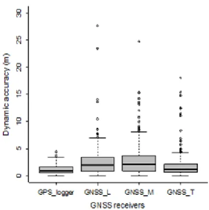
found. The median of the dynamic accuracy over the
whole test period of four days was 1.02 m for the GPS
data logger, 1.31 m for GNSS_T, 1.81 m for GNSS_L
and 2.07 m for GNSS_M (Box-Whisker Plots in Figure 3).
Furthermore, we found significant differences (P≤0.05)
among most of the testing days for each tested GNSS
receiver and GPS data logger. This was the influence of
different satellite constellations at the certain time of the
tested day. Although this study was planned to repeat
over the four testing days within the same time span,
weather influences such as thunderstorm and strong wind
on the dynamic test apparatus resulted in interruption and
postponing the test on days 1, 2 and 3. Nevertheless the
planned total interval of eight hours per tested day was
completed.
The results of this study are comparable with a similar
rotational apparatus of Stombaugh et al. (2002) who
presented the dynamic accuracy (distance between all
measured positions and the actual antenna location) of
four different GPS receivers in the range from 0.06 to
2.03 m. Other authors such as Taylor et al. (2003) and
Min et al. (2008) presented dynamic accuracies of various
GPS receivers ranging on average from 0.17 to 1.35 m
and 0.63 to 1.20 m, respectively. Nevertheless, these
authors applied a different system of dynamic testing
using railroad tracks or tractors as well as relief and
canopy. Overall it is expectable to obtain much lower
accuracy when GNSS cattle tracking systems will be used
in areas with difficult topographical and canopy
environment. On the other hand for the herdsman even
the position fixes with low accuracy are helpful for his
daily routine work with animals.
3.3 Livestock movement monitoring based on GNSS
data
One of the aims of this study was to analyse the
influence of different GNSS fix intervals (intervals of
successive positions) on the mean distance travelled by
cows on AFs. The mean distance travelled depending on
GNSS fix interval is presented in Figure 4. There is a
strong decrease of information with increasing GNSS fix
interval between two successive observations (Figure 4).
Increasing the interval even from 5 to 10 min resulted in a
reduction rate of 38% of the travelled distance (from 305
m/h to 189 m/h). If we increased the interval from 5 to 60
minutes, only 16% of information on distance travelled
was left (49 m/h). Similar results were presented in the
study of Perotto-Baldivieso et al. (2012) where the
highest reduction in rate of distance travelled by cows on
free ranged pastures in Texas and New Mexico occurred
between 5 and 60- min intervals.
Furthermore, analysis on autocorrelation problems of
successive observations, described in several studies
(Minta, 1992; Perotto-Baldivieso et al., 2012) was part of
our study as well. For proper analyses of interactions
between livestock and environment, autocorrelation
should be removed from sequential sampling datasets
(Swihart and Slade, 1985; Minta, 1992). In this study the
successive distances between GNSS locations were Figure 4 Means and standard error bars (black line) for average distance travelled by cows (in m/h) and the resulting amount of information in % (red line) for different time intervals between successive GNSS fixes-
significantly correlated when time interval was lower
than 60 min (one heifer) and 120 min (two heifers).
Similarly, Perotto-Baldivieso et al. (2012) presented
significant correlations by the time intervals lower than
90 min (Texas locality) and 120 min (New Mexico
locality) and suggested that in semiarid ecosystems of
Southwestern United States the autocorrelation between
successive observations can be minimized by intervals of
at least 2 h. Nevertheless, the environmental and
topographical conditions as well as number of animals
used in our and the mentioned study were very different.
Overall, the results concluded the antagonism among time
intervals between successive locations needed to properly
calculate distances travelled or to interpret cattle grazing
patterns and interaction with environment.
Perotto-Baldivieso et al. (2012) proposed to collect the
data within small time intervals and if needed, subsample
the data for specific statistical analyses. In this case there
is still need in improvement of battery life management in
order to reach the full pasture period on alpine pastures.
The information collected would be helpful for further
research and afterwards for development of supportive
systems helping herdsman to early recognize misbalances
in behaviour or healthy status of the grazing animals.
4 Conclusions
The main results of this study focusing on
development and test of new tracking systems based on
GNSS- and GSM- technology together with analyses of
movement patterns of cattle and the workload of
herdsman on alpine pastures showed that:
The activity “control of animals” is most time
consuming for the herdsmen on alpine farms with young
cattle.
Cattle tracking system has therefore potential for
optimizing the workload of a herdsman and the pasture
management by:
- reduction of time needed to control the animals on
the pasture;
- elimination of time spent to search lost animals;
- application of geo-fencing in unfenced areas;
- earlier recognition of un- or under grazed pasture
areas based on visualization of tracking data.
On the other side, technical improvements especially
in battery management of tracking systems are still
necessary before final implementation.
The analysis of livestock movement based on GNSS
data pointed out the antagonisms among specific
questions related to behaviour of grazing animals and
time intervals of consecutive GNSS fixes needed for such
analyses.
Further research with focus on behavioural analyses
using other sensors like accelerometers incorporated into
GNSS tracking system will be performed.
Acknowledgements
This project was funded by the German Federal
Ministry of Food and Agriculture, the Federal Office for
Agriculture and Food, project number: 28154T2110. The
authors would further like to thank the herdsmen, who
carefully recorded the labour input during the study
period and the farmers providing the alpine farms with
pasture and young cattle for the project.
References
Augustine, B. C., P. H.Crowley, and J. J. Cox.2011. A mechanistic model of GPS collar location data: Implications for analysis and bias mitigation. Ecological Modelling, 222: 3616-3625. Craighead, F. C. 1982. Track of the grizzly. New York: Random
House.
Ellmauer, S. 2005. Almen – Die grünen Dächer der Alpen,
AlpenVerein 2/05,
12-16.(http://www.alpenverein.com/portal_wAssets/z_alt/p ortal/Home/Downloads/Alpenverein_2_05/Ellmauer_aus_2 _05.pdf, last accessed 23.07.2014).
Gfeller, P. 2010. Bleibt die Milchproduktion im Berggebiet? Ausstieg Milchkontigent Schweiz – was kann Österreich daraus lernen? In: Landtechnik im Alpenraum, Feldkirch, Austria.
Guo, Y., G.Poulton, P.Corke, G. J.Bishop-Hurley, T. Wark, and D. L. Swain.2009. Using accelerometer, high sample rate GPS and magnetometer data to develop a cattle movement and behavior model. Ecological Modelling, 220: 2068-2075. Handler, F., M.Kriegler, E. Blumauer, and H. Gremmel. 1999.
Arbeitszeitbedarf auf Almen. Forschungsbericht der BLT, 44.
Kompf, M. 2014. Entfernungsberechnung. (2011-2014).
(http://www.kompf.de/gps/distcalc.html, last accessed 23.07.2014).
Min, M., R.Ehsani, and M. Salyani.2008. Dynamic Accuracy of GPS Receivers in Citrus Orchards. Applied engineering in Agriculture, 24: 861–868.
Minta, S. C. 1992. Tests of spatial and temporal interaction among animals. Ecological Applications, 2: 178-188.
Maxa, J., S.Thurner, and G. Wendl.2014. Field investigations and comparison of different GPS-GSM tracking systems suitable for cattle in European Alpine areas. Proceedings International Conference of Agricultural Engineering, Zurich, Paper Number: C0252.
Perotto-Baldivieso, H. L., Cooper, S. M., Cibils, A. F., Figueroa-Pagán, M., Udaeta, K., and Ch. M., Black-Rubio.2012. Detecting autocorrelation problems from GPS collar data in livestock studies. Applied Animal Behaviour Science, 136: 117-125.
Rutter, S. M., N. A.Beresford, and C. Roberts.1997. Use of GPS to identify the grazing areas of hill sheep.Computer and Electronics in Agriculture, 17: 177–188.
Spink, A., B.Cresswell, A. Kölzsch, F.van Langevelde, M.Neefjes, N. P. J. J. Noldus, H. van Oeveren, H.Prins, T.van der Wal, N. de Weerd, and W. Frederik de Boer. 2013. Animal behavior analysis with GPS and 3D accelerometers. European Conference on Precision Livestock Farming 2013, Leuven, Belgium.
Stombaugh, T., S. A.Shearer, and J. Fulton.2002. Elements of a Dynamic GPS Test Standard. 2002 ASAE Annual International Meeting, Paper Number: 021150.
Swihart, R. K., and N. A. Slade. 1985. Influence of sampling intervals on estimates of home range size. Journal of wildlife management, 49: 1019-1025.
Taylor, R. K., M. D.Schrock, J.Bloomfield, G.Bora, G.Brockmeier, and W. Burton. 2003. Dynamic Testing of GPS Receivers. 2003 ASAE Annual International Meeting, Paper Number: 031013.
Thurner, S., G.Neumaier, P. O.Noack, and G. Wendl.2011. Reduction of labour input by a GPS-based livestock tracking system on alpine farms with young cattle. XXXIV CIOSTA & CIGR V Conference in Vienna, Austria, 139-142.
Turner, L. W., M. C.Udal, B. T.Larson, and S. A. Shearer. 2000. Monitoring cattle behavior and pasture use with GPS and GIS. Canadian Journal of Animal Science, 80: 405-413. Ungar, E. D., Z.Henkin, M.Gutman,A.Dolev, A.Genizi, and D.