Agrogeosystems of Krasnoyarsk Krai:
Natural resource potential, environmental
stability, optimization of functioning
Alexander A. Shpedt
1,2, Alexander N. Petin
3, Yury N. Trubnikov
3,
Yulia V. Aksenova
4, Lidia G. Smirnova
3, Tatiana A. Polyakova
3 1Department of Geography, Siberian Federal University, Pr. Svobodny, 79, Krasnoyarsk, 660041, Russia, 2Department of Geography, Krasnoyarsk Agricultural Research Institute, Federal Research Center “Krasnoyarsk Scientific Center of the Siberian Branch of the RAS”, Pr. Svobodny, 66, Krasnoyarsk, 660062, Russia,3Department of nature management and land cadastre; department of geography and geoecology, Belgorod State National Research University, Ul. Pobedy, 85, Belgorod, 308015, Russia, 4Department of agrochemistry and soil sciences, P.A. Stolypin Omsk State Agrarian University, Institutskaya pl., 2, Omsk, 644008, Russia
Abstract
Aim: The article presents the estimation of natural resource potential (NRP) of agrogeosystems of taiga-forest and forest-steppe zones, environmental stability and anthropogenic transformation to further optimization of their functioning. Methods: Agrogeosystems of the typical forest-steppe possess the greatest NRP; the ones of the south taigaforest zone have middle potential. Agrogeosystems of the open forest-steppe adjoining to a large megalopolis possesses low potential. The intensification of farming determines the degree of anthropogenic transformation of the territory. Agrogeosystems of the open and typical forest-steppe are environmentally unstable, but those of the south taiga-forest zone are stable, which is determined by a small fraction of plowland in the total structure of land resources and extensive territory of subtaiga, occupied by forests of natural origin and idle lands. Result and Discussion: The integral estimation of the whole set of climatic, soil, hydrological, geomorphological, and geological components allows to state the agrogeosystem of the typical foreststeppe has the largest NRP, the one of the taiga-forest zones possesses the middle NRP, and the agrogeosystem of the open forest-steppe, located near a large megalopolis, has the lower NRP.
Conclusion: Long-term application of organic fertilizers on gray forest soils of subtaiga increases the humus content and base saturation reduces the acidity of the soil, provides a positive balance of elements of a mineral delivery, which causes an increased reproduction of fertility and stabilizes a high level of production processes in the agrolandscape.
Key words: Agrogeosystem, anthropogenic transformation, ecological stability, natural and resource potential
Address for correspondence:
Alexander A. Shpedt, Siberian Federal University, Pr. Svobodny, 79, Krasnoyarsk, 660041, Russia. E-mail: shpedtaleksandr@ rambler.ru
Received: 09-09-2017
Revised: 16-09-2017
Accepted: 20-09-2017
INTRODUCTION
A
grolandscapes are subjected to a deep anthropogenic impact. Intensity and direction of transformations depend on a farming system and their resistance to agrogenic stress.[1-5] Today an adaptive landscape system offarming is widely practiced; it has certain forms of territory organization[6-8] taking into account
vertical and horizontal transfer of energy and mass in the structural and functional hierarchy of landscapes. In the ideal form, a formation of the adaptive landscape system of farming is a design of the optimal agrolandscapes in the rational ratio with conjugated natural landscapes. According to V.V. Dokuchaev, it consists in the optimization of a ratio of plowland, meadows, forest, and water and the detailed connection of agrotechnical actions to the local conditions.[9]
Ecological state of lands depends not only on the intensity of anthropogenic load on an agrogeosystem but also on the other objects not directly related to agricultural production.[10-12]
The set and ratio of biological, geochemical, social, and other conditions form the ecological basis of the landscape, the most important characteristic of which is its positive stability. Human economic activity should be based on a harmonious combination of environmental and economic laws of nature
ORIGINAL
AR
management, which is achieved by the optimization of agrogeosystem functioning.
The aim of the work was to optimize the functioning of agrogeosystems in the taiga-forest and forest-steppe zones of Krasnoyarsk Krai on the basis of an assessment of their natural resource potential (NRP) and environmental stability.
MATERIALS AND METHODS
The objects of the research are located in the main farming zones of Krasnoyarsk Krai. SPK “Zarechenskoe” is located in the Achinsk-Bogotol natural area of the south taiga-forest zone (sub-taiga). The main arable fund consists of sod-podzolic (19.5%) and gray forest (43.0%) soils. The average yield of cereals does not exceed 1.4-1.8 t/ha. Technological orientation of the economy is extensive.
OOO “OPKh Solyanskoe” is located in the typical forest-steppe in Kansk natural district. Leached heavy loamy chernozem dominates in the soil cover. The direction of economic activity is primary seed-growing, crop production, and animal breeding. The average yield is 2.4-2.8 t/ha, the average annual yield of milk per forage-fed cow is about 5,000 kg. The technological orientation of the economy is directed to the intensification of production with an active use of chemical means (fertilizers and pesticides) and the expansion of agricultural fields.
FGBU “Minino” is confined to Krasnoyarsk natural district. The territory of the economy is a flat, open, south, warm enough part of the Krasnoyarsk forest-steppe with pronounced steppe areas convenient for plowing. The soil cover is mainly presented by chernozem leached, ordinary, and gray forest soils. The soils are actively exploited for three and a half centuries.
Agroclimatic conditions of the zones determine a set of adaptive crops and varieties, the choice of technological methods for their cultivation, which directly affects the degree of anthropogenic load on the agrolandscapes.
There are various methods for assessing the factors of the formation of agrogeosystems: Natural resource, labor resource, and investment potentials.[13-15]
Calculation and evaluation of NRP were carried out on the basis of the approach set out in the scientific publication.[15]
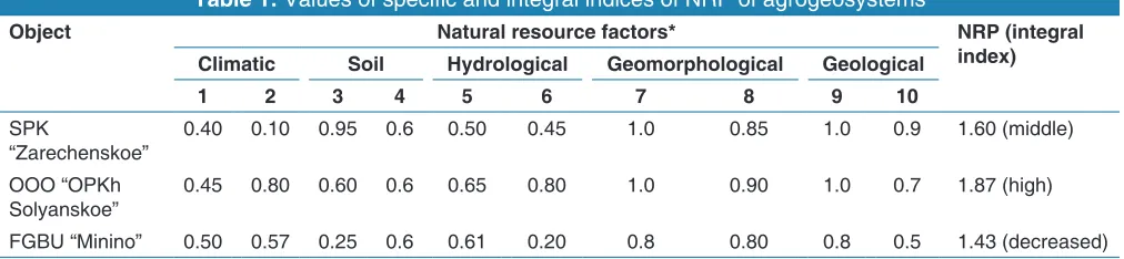
The estimation of the integral index of NRP was carried out according to the following scale: 1.27-1.41 - low, 1.42-1.56 - decreased, 1.57-1.71 - middle, 1.72-1.86 - increased, and 1.87-2.01 - high.
To assess the influence of land composition on the environmental stability of the agrogeosystem we determined
the coefficient of ecological stability (Cec.st.).[16] With
the value of Ces.st. <0.33 the territory was considered ecologically unstable. If Cec.st. was from 0.33 to 0.66 the territory had the middle stability, and with Cec.st. more than 0.67 it was considered environmentally stable.
To assess the degree of anthropogenic transformation of the agrogeosystems we used the approaches, developed by Lemeshev et al.,[17] Shchishchenko.[18] The value of
the coefficient of anthropogenic transformation (Can.tr.) varies within 0<Can.tr. <10 and characterizes the following regularity: The larger the area of the type of land use and the higher the index of transformation intensity of landscape complexes, the more the agrosystem is transformed by economic activity.
The coefficient of anthropogenic transformation was estimated according to the following scale: 2.0-3.80 - slightly transformed, 3.81-5.30 - transformed, 5.31-6.50 - medium transformed, 6.51-7.40 - strongly transformed, and 7.41-8.0 - very strongly transformed.
For a comparative analysis of morphological characteristics and agrochemical properties, the soils of personal plots (Zarechenka, Tyukhtet district) attached to the central branch of agricultural production cooperative “Zarechenskoe,” long used for monoculture of potato and soils in virgin state, were subjected to a survey, which allowed calculating the balance of nutrients against the background of application of organic fertilizers in the form of manure.
Soil profiles were located in the upper part of the watershed plateau on gray forest soil, at a distance of 20 m from each other. Soil samples were selected from each genetic horizon. Agrochemical indicators were determined by conventional methods.[19]
Removal of elements with harvest was determined taking into account the chemical composition of the main and incidental potato culture (the yield was 12 t/ha). A positive balance item of the elements was calculated taking into account the average number of animals in personal economies. Using the normative data on the output of litter manure from one head for a stabling period of 200 days and the chemical composition of various types of manure, a receipt balance sheet item was calculated. Over a 100-year period, 1500 tons of manure were applied into the soil.
RESULTS AND DISCUSSION
open forest-steppe, located near a large megalopolis, has the lower NRP [Table 1].
The distribution of NRP index in the zonal aspect is in good agreement with the model data of spring wheat productivity. According to mathematical models,[20] the greatest yield can
be obtained under typical forest-steppe conditions; the taiga-forest zone is more favorable for crop cultivation than the open forest-steppe.
It was established that the south taiga forest agrogeosystems had high ecological stability (Cec.st. was 0.69) and the least anthropogenic transformation (Can.tr. was 4.19). The agrogeosystems of the open and typical forest-steppe are not stable (Cec.st. was, respectively, 0.31 and 0.30) and strongly transformed (Can.tr. was 6.49 and 6.56, respectively). These indicators are mainly stipulated by the low share of arable land in the overall structure of land resources and the vast territory occupied by forests of natural origin and idle lands. The areas of use of sod-podzolic and gray forest soils have declined significantly, especially in districts and farms with a weak economic and social base. The current ecological situation is the result of the economic and social degradation of the subtaiga part of the region and not the implementation of the paradigm of a safe and sustainable ecosystem.
In OPKh “Solyanskoe” and FGBU “Minino” the percentage of plowed area is extremely high, 70% and 67%, respectively, which determines the strong anthropogenic transformation and ecological instability of the agrogeosystems. The indicators characterizing the agrogeosystems of the open and the typical forest-steppe are similar in their values. There is much more arable land in OOO “OPKh Solyanskoe” in comparison with FGBU “Minino,” hence the low Cec.st., but the proportion of chernozems in the structure of the soil covers is significantly larger. The predominance of some and the reduction of other elements of landscapes and lands, differing in their influence on the ecological stability of the territory in the structure of agrogeosystems, determined their almost identical ecological state.
The ratio of net primary production to total primary production is the efficiency of net production (ENP). The assessment of ENP provides the basis for correction of indicators characterizing the agrolandscape, both as the environment for the production of agricultural products and as the system that determines the ecological state of the territory. American ecologists found that ENP is 85% for perennial grasses and cereals, 77% for corn, 62% for alfalfa, 45% for pine forest, and 85% for bog (duckweed).[21] Under
conditions of Central Siberia for cereals, ENP is 82%[22] on
chernozems of the forest-steppe and 77%[23] on gray forest
soils of subtaiga agrolandscapes. Primary productivity can be estimated in tons of dry organic matter synthesized per year on an area of 1 hectare, or in calories. Thus, the primary productivity is expressed in kcal/year/m2, which allows the
comparison of different ecosystems.[24]
In our opinion, the assessment of energy resource of an agrolandscape by ENP gives a basis for differentiation of the coefficient of ecological stability used for estimation of arable land. It is advisable to use a coefficient of 0.14 only for fallow fields in the structure of the arable land, but now it is utilized for the entire area of arable lands. For sown areas, the use of the law of the ecological equivalent is justified.[25,26] In
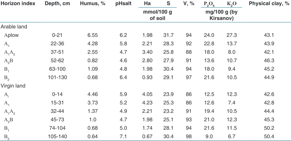
this case, the coefficient is used differentially, depending on the specific crop groups and the structure of the acreage. Such differentiation will change the rating of agrogeosystems. OOO “OPKh Solyanskoe,” which has the maximum area of arable land, and, for this reason, the minimum Cec.st., possibly, will be described as an ecologically stable agrogeosystem. As an example of an environmentally stable, and at the same time, highly transformed agrolandscape, with the transformation of physicochemical and agrochemical properties of soils that determine the production processes in agrocenoses, a private plot is represented. The task of the study was to determine the scope and direction of changes in the main indicators of fertility of gray forest soils under prolonged potato monoculture [Table 2].
Soils, coincided with different types of land, have one genetic characteristic. The content of humus in the soil for 100 years of use increased 1.5 times in comparison with the virgin
Table 1: Values of specific and integral indices of NRP of agrogeosystems
Object Natural resource factors* NRP (integral
index)
Climatic Soil Hydrological Geomorphological Geological
1 2 3 4 5 6 7 8 9 10
SPK
“Zarechenskoe” 0.40 0.10 0.95 0.6 0.50 0.45 1.0 0.85 1.0 0.9 1.60 (middle) OOO “OPKh
Solyanskoe” 0.45 0.80 0.60 0.6 0.65 0.80 1.0 0.90 1.0 0.7 1.87 (high) FGBU “Minino” 0.50 0.57 0.25 0.6 0.61 0.20 0.8 0.80 0.8 0.5 1.43 (decreased)
land, while the content of available forms of phosphorus and potassium doubled. Significant changes also occurred with physicochemical indicators. To determine the factors of formation and transformation of soil fertility and the cycle of substances as the basis for the functioning of the agrogeosystem, the balance of nutrients in gray forest soil was calculated for potato monoculture [Table 3].
Systematic application of manure for 100 years provides a positive balance of plant nutrients, which makes it possible to obtain good potato harvests and serves as a condition for enhanced reproduction of soil fertility.
CONCLUSION
Assessment of natural climatic, soil and geological conditions show that agrogeosystems of typical forest-steppe have the greatest NRP, the ones of the south taiga-forest zone have middle potential, and agrogeosystems of the open forest-steppe have decreased potential. Agrogeosystems of the south taiga forest zone are characterized by high ecological stability and the least anthropogenic transformation. Agrogeosystems of open and typical forest-steppe are not stable and are strongly transformed. Intensification of agriculture determines the degree of anthropogenic transformability of the territory. Long-term (100 years) application of manure on gray forest soils of subtaiga increases the humus content and base saturation, reduces the acidity of the soil, provides a positive balance of nitrogen, phosphorus, potassium, calcium, and magnesium, which causes an increased reproduction of fertility and stabilizes a high level of production processes in the agrolandscape.
SUMMARY
Agrogeosystems of the typical forest-steppe have the greatest NRP, of the south taiga-forest zone - the average one; and agrogeosystems of the open forest steppe have decreased potential. Agrogeosystems of the forest-steppe are unstable and strongly transformed by economic activities. A small share of arable land in the general structure of land resources and significant areas occupied by forests and idle lands provide high ecological stability and the least anthropogenic transformation of the agrogeosystem of the southern taiga-forest zone.
REFERENCES
1. Elena AK. Agricultural production as a factor of biogeochemical transformation of trace element
Table 2: Agrochemical and physicochemical properties of gray forest soil under intensive agrogenic force and
its virgin analog
Horizon index Depth, cm Humus, % pHsalt Ha S V, % Р2О5 К2О Physical clay, %
mmol/100 g
of soil mg/100 g (by Kirsanov)
Arable land
Аplow 0‑21 6.55 6.2 1.98 31.7 94 24.0 27.3 43.1
А1 22‑36 4.28 5.8 2.21 28.3 92 22.8 13.7 43.9
А1А2 37‑51 2.55 4.7 3.40 25.8 88 18.0 8.0 42.1
А2В 52‑62 0.82 4.6 2.80 27.9 91 13.6 10.7 46.3
В1 63‑100 1.09 4.8 1.98 30.4 94 18.0 9.4 45.2
В2 101‑130 0.68 6.4 0.93 29.1 97 21.6 10.5 44.9
Virgin land
Аl 0‑14 4.46 5.9 4.05 23.9 86 12.5 12.3 42.6
А1 15‑31 3.73 5.2 4.23 25.3 86 12.6 7.4 42.8
А1А2 32‑44 1.37 4.9 2.21 23.2 91 19.4 10.5 44.4
А2В 45‑73 1.0 4.7 1.98 25.1 93 21.0 12.3 45.3
В1 74‑104 0.68 5.0 1.74 28.1 94 21.6 11.5 50.2
В2 105‑140 0.64 7.1 0.67 30.4 98 9.0 6.7 50.4
Table 3: Balance of nutrients in gray forest soil,
kg/ha
Balance
characteristics N Р2О5 К2О СаО+МgО
Applied with
manure 9100 4400 13500 6900
Removal with
yield 6400 2200 10500 2900
Balance 2700 2000 3000 4000
Balance
compounds in various agroland scape soils. Ecologica 2009;2:299-302.
2. Kotlyarova EG, Cherniavskih VI, Dumacheva EV. Ecologically safe architecture of agrolandscape is basis for sustainable development. Sustain Agric Res 2013;2:11-23.
3. Opp C. Actual problems of loadability and load in agroecosystems. Ecol (CSFR) 1991;10:373-88.
4. Kalinchuk IV, Mikhailov VA, Pozachenyuk EA. Estimation of anthropogenic transformation of plain Crimean landscapes, Belgorod state university scientific bulletin. Nat Sci 2016;25:156-68.
5. Belitskaya YS, Kornilov AG. About an assessment of an ecological situation of agro-economic territories, the caused extra production anthropogenous loading, Belgorod state university scientific bulletin. Nat Sci 2012;21:140-3.
6. FAO. Guidelines for Land-Use Planning, FAO Development Series No. 1. Rome, Italy: FAO; 1993. p. 96.
7. Ozeranskaya N, Karbozov T, Bekturganova A, Zhuparkhan B, Kononova V. Optimization of land use in the agricultural landscapes of northern Kazakhstan on the basis of the landscape approach. Res J Pharm Biol Chem Sci 2016;7:1788-97.
8. Turner M, Gardner RH, O‘Neill RV. Landscape Ecology in Theory and Practice: Pattern and Process. New York: Springer-Verlag; 2001. p. 352.
9. Dokuchaev VV. Selected Works. Vol. 3. Moscow: State Publishing House for Agricultural Literature; 1949. p. 444.
10. Petersen GW, Nizeyimana E, Miller DA, Evans ВM. The use of soil databases in resource assessments and land use planning. In: Sumner ME, editor. Handbook of Soil Science. United States: CRC Press; 2000. p. 69-94. 11. Le Bas C, Jamagne M. Soil databases to support
sustainable development. Ispra, Italy: INRA, JRC; 1996. p. 150.
12. FAO. Land Quality Indicators and Their Use in Sustainable Agriculture and Rural Development Land and Water Bull 5. Rome: FAO; 1997.
13. Sarmadian F, Keshavarzi A, Rooien A, Zahedi G,
Javadikia H, Iqbal M. Support vector machines based-modeling of land suitability analysis for rainfed agriculture. J Geosci Geomatics 2014;2:165-71.
14. Doran JW, Jones AJ, editors. Methods for Assessing Soil Quality. Vol. 49. United States: SSSA Special Publication; 1996. p. 416.
15. Kurolap SA, Fedotov VI, Yu KV. Integral Assessment of Natural Resource Potential, Medico-Ecological Atlas of Voronezh Region: Monograph. Voronezh; 2010. p. 10-5. 16. Volkov SN. Land Management, Land Use Planning,
Farm Boundary Adjustment. Vol. 2. Moscow: Kolos; 2001. p. 648.
17. Ya LM, Anuchin VA, Gofman KG Scientific Basis of Socialist Nature Management, Socialism and Nature. Moscow: Mysl; 1982. p. 15-9.
18. Shchishchenko PG. Applied Physical Geography. Kiev: Vysshaya Shkola; 1988. p. 37-43.
19. Volf VG. Agrochemical Methods of Soil Investigation. Moscow: Nauka; 1975. p. 656.
20. Brylev SV. Farming system of Krasnoyarsk Krai on the landscape basis: Research and practice recommendations. Krasnoyarsk: RASTR; 2015. p. 224.
21. Ricklefs R. Ecology. Moscow: Mir; 1979. p. 424. 22. Yu NT, Chlenova TI. Efficiency of fertilizers on leached
chernozem of kan forest-steppe of Krasnoyarsk Krai. Achiev Sci Technol Agric Sec 2014;6:27-30.
23. Yu NT. Mineral fertilizers and productivity of a field crop rotation under conditions of subtaiga of Siberia of Yenisey region. Farming 2011;5:13-4.
24. Ramad F. In: Matveeva LT, editor. Basic Concepts of Applied Ecology Translated from French. Leningrad: Gidrometeoizdat; 1981. p. 543.
25. Yu O. In: Naumov NP, editor. Basic Concepts of Ecology Translated from English. 3rd ed. Moscow: Mir; 1975.
p. 309.
26. Odum E. Properties of agroecosystems. Agroecosystems: Unifying Concepts. New York: John Wiley and Sons; 1984. p. 5-11.