Dhahal structure: an example of transpression
associated with the Dead Sea transform in Wadi
Araba, Jordan
MOHAMMAD ATALLAH1, HAKAM MUSTAFA1, HANI EL-AKHAL1& MASDOUQ AL-TAJ2
1Department of Earth and Environmental Sciences, Yarmouk University, Irbid-Jordan
2Department of Earth and Environmental Sciences, The Hashemite University, Zarqa-Jordan
ABSTRACT:
ATALLAH, M., MUSTAFA, H., EL-AKHAL, H. & AL-TAJ, M. 2005. Dhahal structure: an example of transpression asso-ciated with the Dead Sea transform in Wadi Araba, Jordan. Acta Geologica Polonica, 55 (4), 361-370. Warszawa.
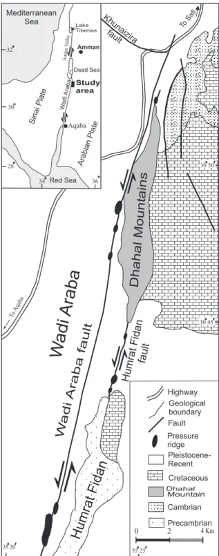
The Dhahal Mountains located at the eastern margin of the northern Wadi Araba sinistral fault represent an example of a transpression associated with the Dead Sea transform, which is a sinistral wrench fault. This structure was formed as a result of right bending of the Humrat Fidan active sinistral fault, which is a parallel strand of the Dead Sea trans-form located east of the main Wadi Araba fault. The fault bend caused uplift and squeezing of the Cretaceous and Tertiary rocks of the transpression. Positive flower structures, folds, fault-bounded wedge-shaped pop-ups and reverse faults are the main structural elements that characterized the Dhahal transpression. Folds are found as sets or as sin-gle anticlines and synclines. The major trend of the fold axes is N50°; the principal stress axis (σ1) is perpendicular to this trend (N140°). This trend deviates 26° anticlockwise from that of the Dead Sea stress system (DSS) (as obtained from fault slip data north of the study area), which is responsible for the formation of the Dead Sea transform. Evidence of active uplift in the Dhahal structure is provided by the sharp topography relative to the surrounding areas, and the low mountain front sinuosity index of the western margin of the Dhahal mountains.
Key words: Dhahal structure, Transpression, Dead Sea transform, Wadi Araba.
INTRODUCTION
The trace of a continental strike-slip fault may show a change in the strike direction. This change in strike is called a bend. In some cases, the fault trace is not con-tinuous but is composed of fault segments or steps. Depending on the sense of fault displacement (right-lat-eral or left-lat(right-lat-eral) and the direction of bend or step (right-hand or left-hand bend or step), local compression or tension is formed along the strike-slip faults. Bends or steps associated with local tension are called release bends or steps, while bends or steps associated with local compression are called restraining bends or steps. Transpressions (pressure ridges) and transtensions
transform, particularly those accompanying the forma-tion of pressure ridges, in the light of the modern trends of strike-slip tectonics.
The Dead Sea transform (DST) is a sinistral wrench fault. It is part of the 6000 km long Afro-Arabian rift
system, extending from Mozambique to Turkey, form-ing a transform boundary connectform-ing the Red Sea with the Taurus-Zagros mountains and separating the Arabian plate from the Sinai-Palestine plate. Reconstruction of offset geological formations and structural features show that lateral displacement on the DST occurred in two steps: 62 km of offset by the early Miocene, and 45 km of offset since the late Miocene (QUENNELL 1958; FREUND & al. 1970). The seismic, historical, and archaeological records of the Dead Sea region show that large earthquakes are known to have occurred along the Dead Sea transform (POIRIER & TAHER 1980; ABOU KARAKI 1987; AMBRASEYS& al. 1994). The recent seismic activity has been low, especially along the the Wadi Araba strike-slip fault. This may indicate that the recurrence of very strong earthquakes generated along the Wadi Araba fault is at long time-intervals, or the paucity of earth-quakes may be due to aseismic creep along the Wadi Araba fault. The estimated geological slip rate of 6-10 mm/yr for the DST is based on a cumulative offset of 107 km of pre-Miocene rocks (QUENNELL1958; ZAK& FREUND1966; FREUND& al. 1970). Based on an aerial photograph reconnaissance of the DST and earthquake catalogue information, GARFUNKEL & al. (1981) sug-gested that the present-day slip rate has been slower (1.5-3.5 mm/yr) than the Plio-Pleistocene rates. Recent work on offset alluvial fan surfaces and drainages along the northern Wadi Araba fault indicates a slip rate of 4.7 mm/yr (NIEMI& al. 2001) and 4 mm/yr (KLINGER&
al. 2000).The transform consists of a series of narrow
troughs, mostly 10–20 km wide, bordered mainly by normal faults (BENAVRAHAM1985). The trough basins are commonly occupied by rhomb-shaped pull-apart depressions like the Dead Sea and the Hula basin and, less commonly, by pressure ridges like the Lebanon upwarp. In Jordan, the Dead Sea transform consists of three morphotectonic segments, the Wadi Araba fault (WAF) in the south, the Dead Sea basin in the middle and the Jordan Valley fault (JVF) in the north (Text-fig. 1). Pressure ridges and pull-apart basins of variable sizes were described along the trace of the Dead Sea transform (GARFUNKEL& al. 1981; GALLI1999; AL-TAJ 2000; NIEMI& al. 2001). The exposed deformed rocks are mainly unconsolidated Pleistocene deposits, with the exception of a series of pressure ridges west of the Humrat Fidan massif, where the deformed rocks are of Upper Cretaceous limestone (GALLI1999).
The northern Wadi Araba fault and the parallel secondary Humrat Fidan fault are locally irregular; they bend to the right in many places, forming pres-sure ridges of different sizes (Text-fig. 1). The Dhahal structure in the northern Wadi Araba is one of these Fig. 1. Tectonic setting of the Dhahal structure relative to the Wadi Araba
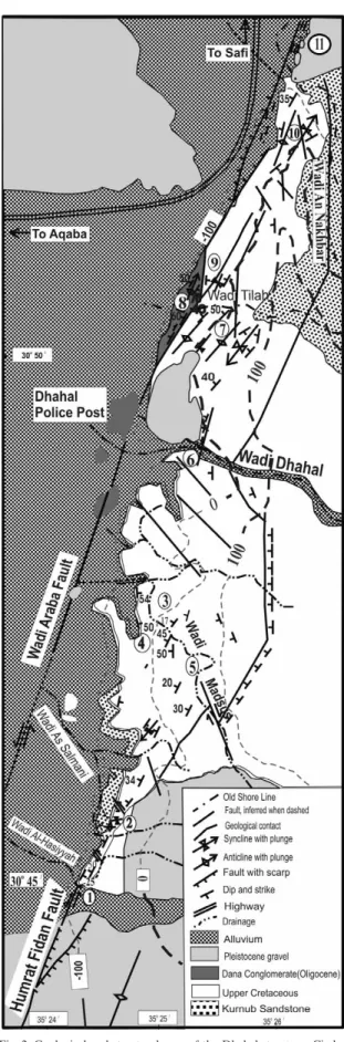
ridges. It forms the eastern margin of the rift for about 15 km. BENDER (1968) considered this structure as comprising steeply dipping strata and west-directed flexures, along which N-S striking normal faults characterize the mountain range bordering this portion of the rift. ATALLAH(1986, 1992) described N-S and NNE-N-SN-SW trending tight anticlines and syn-clines in addition to N-S flexures. The present study depends on field investigation and analysis of aerial photographs at a scale of 1:10 000 of the area extend-ing from Wadi Al-Hasiyyah in the south to Wadi An Nakhbar in the north (Text-fig. 2).
GEOLOGICAL SETTING
The wedge-shaped fault-bounded Dhahal structure is located at the northern end of the Humrat Fidan active left-lateral strike-slip fault, which commences north of Jabal Humra Fidan (Text-fig. 1). It cuts the alluvial fans and the Pleistocene surfaces. The general strike of the fault trace is N20°E; it is parallel to the Wadi Araba fault and the fault scarp faces eastwards (Text-fig. 3). Between Humrat Fidan and the Dhahal Mountains, three small pressure ridges were formed along this fault (Text-fig. 1). This fault segment is described by BOWMAN(1995) and ATALLAH& ALTAJ(2004). This fault bifurcates into two branches before it hits the Dhahal structure (Text-figs 2-3). A gentle anticline parallel and east of this fault was mapped by RABAA(1991) in the Pleistocene gravel (Text-fig. 2).
The active Wadi Araba fault is located west of the Dhahal structure; it cuts the recent washes of the valleys, forming three pressure ridges, composed of Pleistocene gravels or Dana conglomerate, the largest one of which being the Dhahal police post hill (Text-fig. 2). North of Wadi Dhahal, the Wadi Araba fault forms the western front of the Dhahal Mountains, but north of Wadi Tilah, it bifurcates into two strands: the eastern one sticks to the mountain front, and the western one cuts the fan sur-faces west of the Dhahal Mountains (Text-fig. 2). Evidence of active movement described along this fault comprise the offset of alluvial fan surfaces, offset of stream courses, formation of pressure ridges and sag ponds (ZHANG1999; NIEMI& al. 2001). This fault con-tinues to the north, crossing Wadi An Nakhbar and Wadi Khunaizira.
North of Wadi An Nakhbar, the Dhahal structure terminates as a series of pressure ridges of Pleistocene conglomerate, with preserved shorelines of the Lake Lisan (ATALLAH& al. 2002). The Dhahal structure is sep-arated from the Upper Cretaceous rocks to the east by NNE and N-S faults. A difference in the erosional
sur-Fig. 2. Geological and structural map of the Dhahal structure. Circled
faces of the Upper Cretaceous rocks outside and inside the Dhahal structure is observed on the aerial pho-tographs. The rocks outside the structure show smooth topography with dark desert varnish, while those inside the structure show sharp and fresh topography and light coloration; the mountains have pointed peaks and steep sided valleys. These features are good indications of active uplift of the Dhahal Mountains relative to the sur-rounding areas.
STRATIGRAPHY
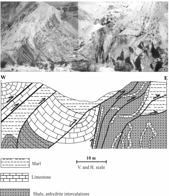
The exposed rocks in the Dhahal area are mainly of Cretaceous, Neogene and Quaternary age (Text-fig. 2). The Cretaceous rocks consist of the Lower Cretaceous Kurnub Sandstone Group and Upper Cretaceous car-bonates. The Upper Cretaceous rocks consist mainly of alternating beds of limestone, dolomite, marl, mudstone and marly limestone. The mudstone beds contain thin beds of laminated and fibrous gypsum (TARAWNEH 1992). These rocks are incompetent upon restraining, forming tight folds, while the thick limestone beds are competent, forming wider interlimb angles (Text-fig. 4). The Neogene beds consist of Dana conglomerate out-crops at the mouth of Wadi Tilah and form some pres-sure ridges along the Wadi Araba fault (Text-fig. 2). The Pleistocene sediments consist of fluviatile conglomerates and gravels. Alluvial sediments (Holocene) are differen-tiated into alluvial fans, alluvium and alluvial gravels (TARAWNEH1992)
Fig. 3. Aerial photograph at a scale of 1: 10 000 for the southern part
of the Dhahal structure. It shows the active sinistral Fidan fault
cross-ing the Pleistocene gravels and the drainage system. The fault trace in
this photograph forms an eastward facing scarp
DESCRIPTION OF THE STRUCTURE
The Dhahal structure commences in the south, where a narrow and elongated Upper Cretaceous block emerges above the Pleistocene deposits along the trace of the Humrat Fidan fault (Text-fig. 2, location 1). The beds dip to the west at 50°. Farther to the north, the Dhahal moun-tains have been affected by folding and fracturing. The folds occur either in sets or as isolated anticlines and syn-clines.
Four fold sets as well as two isolated synclines and one anticline could be distinguished in the Dhahal
structure. One left-handed high-angle fold set arranged en echelon is located at the southern end of the Dhahal structure (Text-fig. 2, location 2). It consists of two short extended anticlines and a syncline, with axes trending ENE-WSW (fig. 2, location 2; Text-fig. 3). The limbs of these folds are highly fractured. The second left-handed en echelon fold set consists of two synclines and two anticlines and is located between Wadi Dhahal and Wadi Tilah (Text-fig. 2, location 7); it trends NNE-SSW. The third fold set, consisting of one syncline and one anticline, is located northwest of Wadi Tilah (Text-fig. 2, location 9). The most northern
Fig. 5. A faulted syncline in the thick limestone beds surrounded by tight folds in the thin beds of gypsum and shale as exposed along Wadi Dhahal. The axis
fold set is located at the NE corner of the Dhahal Mountains Text-fig. 2, location 10) and trends NNE parallel to the WAF; this set consists of one syncline and one anticline.
North of the northern tributary of Wadi As Salmani, a syncline plunges to the southwest. In the area of Wadi Madsus, a major syncline trends N-S and plunges to the north (Text-fig. 2, location 3), the beds on the two limbs show steep dip angles. West of the major syncline two sinistral faults were mapped strik-ing NW-SE and NE-SW (Text-fig. 2, location 4). Another dextral fault strikes NW-SE, offsetting the eastern boundary fault of the Dhahal structure (Text-fig. 2, location 5).
East of the above-mentioned syncline a complex transpression structure is exposed along the course of Wadi Madsus (Text-fig. 2, location. 5). It consists of tight faulted anticlines and synclines developed in a sequence of gypsum and intercalations of reddish and greenish shale (Text-fig. 4). A larger faulted syncline was formed in thick limestone beds; the syncline axis trends N40°E and plunges to the NE. South of Wadi Dhahal, the beds dip gently to the west and the defor-mation is less than to the south and north. In the lower course of Wadi Dhahal (Text-fig. 2, location 6), a NNE-SSW trending thrust-fault, with a fault-plane dipping to the east, crosses the wadi. The fault is well exposed on the southern bank of the wadi (Text-fig. 5).
Along the course of Wadi Tilah complex structures are exposed. At the mouth of the wadi, the Dana con-glomerate beds dip 60° to the west. These beds were downthrown against the Upper Cretaceous beds along NNE-SSW and NNW-SSE trending faults (Text-fig. 2, location 6). The conglomerate has a wedge-shaped
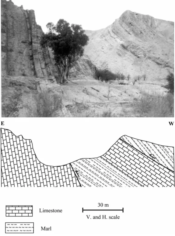
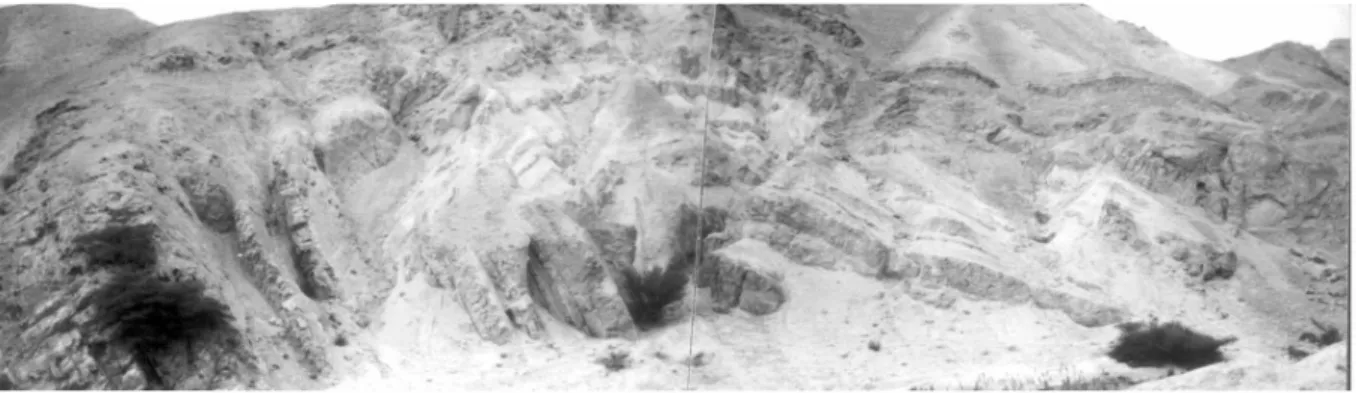
outcrop north and south of Wadi Tilah (Text-fig. 2, location 8). Farther to the east, the Upper Cretaceous beds are highly deformed; the dip angles and direc-tions change very rapidly within a short distance, and in some places the beds are vertical (Text-fig. 6). Many anticlines and synclines were formed; some of the folded beds have undulated bedding planes forming non-cylindrical folds. Text-fig. 7 shows a positive flower structure on the northern bank of Wadi Tilah. Steep bedding-planes and high-angle to vertical faults characterize these transpressions; the fault-planes are wavy and branch upwards, which is a characteristic feature of these structures. In some places, the Pleistocene conglomerate overlies the tilted Upper Cretaceous beds with an angular unconformity; the conglomerate layers also dip to the east, indicating a recent uplift of the transpressions. Text-fig. 8 shows a general cross-section along the southern side of Wadi Tilah, where a number of faulted anticlines and syn-clines were formed. Dip directions change within a short distance.
DISCUSSION
The Dead Sea transform, like other continental strike-slip faults, is associated with transpressions and transten-sions formed as a result of fault bends or steps. Many transpressions of different sizes were formed along the trace of the WAF. The Dhahal transpression is different from the other pressure ridges formed along the Wadi
Araba fault in that it is located at the margin of the form and forms part of the highlands bordering the trans-form. The Dhahal transpression was formed due to the right-hand bend of the Humrat Fidan active left-lateral strike-slip fault, which is a secondary fault parallel to the WAF. The total offset associated with this fault is very small compared with that associated with the WAF. The right-hand bend of the sinistral strike-slip fault caused the
push-up and squeeze of the Upper Cretaceous and Tertiary rocks at the transform margin, forming the fault-bounded wedge–shaped transpression. The internal struc-ture of the transpression shows the effect of compression-al stresses on the deformed rocks: folding; reverse fault-ing, minor fault-bounded wedges and positive flower structures are good indications of such stresses.
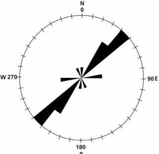
The folds occur either in sets or as isolated anticlines and synclines. Four fold sets (Text-fig. 2 locations 2, 7, 9 and 10) as well as two isolated synclines and one anticline could be distinguished in the Dhahal structure. The folds within the fold sets trend N50° and show an en echelon pattern (Text-fig. 9). The principal stress axis (σ1) is per-pendicular to the major trend of the fold axes and is cal-culated to be N140°. Fault slip data of the Wadi Araba fault were measured in Wadi An Nakhbar and Wadi Khunaizira, north of the study area (ATALLAH & al. 2002): striations on the slickenside surfaces show a major principal stress axis (σ1) of N166°. This trend coincides with the Dead Sea stress system (DSS) (EYAL1996; AL-DIABAT1999). The stress field responsible for the forma-tion of the Dhahal structure deviates locally 26° anti-clockwise from the dominating DSS. Positive flower structures are formed across strike-slip faults inside the large transpression. They can be seen along the wadi courses. The beds of the transpression are highly frac-tured. The configuration of these structural elements coincides with the results of SANDERSON & MARCHINI (1984). Active uplift of the transpression area is indicat-ed from the sharp peaks of the mountains inside the transpression in comparison with the smooth peaks out-side the transpression.
Acknowledgment
This work received financial support from Yarmouk University Research Council (Grant No. 35/99). The authors would like to thank the Jordan Valley Authority for providing accommodation during the fieldwork. Thanks to Eric BLANC, University of Cambridge, and to an anonymous reviewer for their suggestions and comments.
REFERENCES
ABOUKARAKI, N. 1987. Synth¯se et carte sismotectonique des pays de la bordure orientale de la Méditerranee: sismicité du syst¯me de failes du Jourdan-Mer Morte, Ph. D. Thesis, University of Strasbourg, France.
AL-DIABAT, A. 1999. Paleostress and strain analysis of the Cretaceous rocks in the eastern margin of the Dead Sea transform, Jordan, unpub. Ph. D. thesis, University of Baghdad, Baghdad, Iraq.
AL-TAJ, M. 2000. Active faulting along the Jordan Valley seg-ment of the Jordan – Dead Sea transform. Ph. D. thesis, University of Jordan, Amman (Unpubl.)
AMBRASEYS, N., MELVILLE, C. & ADAMS, R. 1994. The seismic-ity of Egypt, Arabia and the Red Sea: a historical review.
Cambridge University Press; Cambridge.
ATALLAH, M. 1986. Application of remote sensing and field tech-niques to structural problems of the Dead sea Rift in Jordan. Ph. D. Thesis, Technical Univ. Munich Unpublished, 154 pp.
— 1992. Tectonic evolution of the northern Wadi Araba, Jordan. Tectonophysics, 204, 17-26.
ATALLAH. M., NIEMI, T. & MUSTAFA, H. 2002. Deformation at a strike-slip, stepover zone along the southern margin of the Dead Sea pull-apart basin, Jordan. EGS Stephan Mueller
Special Publication Series, 2, 1-21.
BENAVRAHAM, Z. 1985. Structural framework of the Gulf of Elat (Aqaba), Northern Red Sea. Journal of Geophysical
Research, 90, 703-726.
BOWMAN, D. 1995. Active surface ruptures on the northern Arava fault, the Dead Sea Rift. Israel Journal of Earth
Sciences, 44, 51-59.
EYAL, Y. 1996. Stress field fluctuations along the Dead Sea rift since the middle Miocene. Tectonics, 15, 157-170.
FREUND, R., ZAK, I, GOLDBERG, M., WEISSBROD, T. & DERIN, B. 1970. The shear along the Dead Sea Rift. Philosophical Transactions of the Royal Society of London, A267, 107-130. GALLI, P. 1999. Active tectonics along the Wadi Araba-Jordan Valley transform fault. Journal of Geophysical Research, 104, 2777-2796.
GARFUNKEL, Z., ZAK, I. & FREUND, R. 1981. Active faulting in the Dead Sea Rift. Tectonophysics, 80, 1-26.
HARLAND, W. 1971. Tectonic transpression in Caledonian Spitsbergen. Geological Magazine, 108, 27-42.
Fig. 10. Rose diagram showing the major trend of the fold axes of the
KLINGER, Y., AVOUAC, J., ABOUKARAKI, N., DORBATH, L., BOURLES, D. & REYSS, L. 2000. Slip rate on the Dead Sea transform fault in northern Araba valley (Jordan). Geophys.
J. Int., 142, 755-768.
NIEMI, T., ZHANG, H., ATALLAH, M. & HARRISON, J. 2001. Late Pleistocene and Holocene slip rate of the northern Wadi Araba fault, Dead Sea transform, Jordan. Journal of
Seismology, 5, 449-474.
POIRIER, J. & TAHER, M. 1980. Historical seismicity in the Near and Middle East, North Africa, and Spain from Arabic documents (VII th-XVIII th century). Bulletin of the
Seismological Society of America, 70, 2185-2201.
QUENNELL, A. 1958. The structure and evolution of the Dead Sea rift. Quaternary Journal of the Geological Society, 64, 1-24.
RABAA, I. 1991. The geology of Al Qurayqira map sheet no. 3015 II. Natural Resources Authority, Amman, Jordan.
SANDERSON, D. & MARCHINI, W. 1984. Transpression. Journal of
Structural Geology, 6, 449-458.
SYLVESTER, A. 1988. Strike slip faults. Geological Society of
America Bulletin, 100, 1666-1703.
TARAWNEH, B. 1992. The geology of the Fifa Area. Map 3051 I. Amman, Natural Resources Authority of Jordan, scale, 1 : 50 000. 46 pp.
WILCOX, R., HARDING, T. & SEELY, D. 1973. Basic wrench tec-tonics. The American Association of Petroleum Geologist
Bulletin, 57, 74-96.
ZAK, I. & FREUND, R. 1966. Recent strike slip movement along the Dead Sea Rift. Israel Journal of Earth Sciences, 15, 33-37.
ZHANG, H. 1998. Late Pleistocene and Holocene slip rate of the northern Wadi Araba fault, dead Sea transform, Jordan. M. Sc. Thesis, University of Missouri-Kansas city, Unpublished, 128 pp.
Manuscript submitted: 10thJune 2003