ed. by Gerd Graßhoff and Michael Meyer, pp. 634–677.
Gerd Graßhoff – Elisabeth Rinner – Mathieu Ossendrijver
– Olivier Defaux – Marvin Schreiber – Emilie Villey
Longitude
Edited by Gerd Graßhoff and Michael Meyer, Excellence Cluster Topoi, Berlin
eTopoi ISSN 2192-2608 http://journal.topoi.org
Except where otherwise noted, content is licensed under a Creative Commons Attribution 3.0 License:
Defaux – Marvin Schreiber – Emilie Villey
Longitude
This study traces the development of the concept of geographical longitude: from the ear-liest known Mesopotamian evidence of geographical concepts through its incorporation into mathematical astronomy and to its transmission to ancient Greek philosophy and scholarship. We show that there is a tight connection between the observation of lunar eclipses and the development of a quantitative representation of terrestrial longitudes. It was not until Ptolemy that geographical longitude was systematically quantified through angular differences. It is demonstrated that the ancient scholars failed in their attempts to determine geographical longitude by astronomical means, and that even certain Syriac texts which specify how to determine longitude using a planispheric astrolabe were unable to resolve this scientific challenge.
Ancient astronomy; ancient geography; cardinal directions; ancient cartography; Mesopo-tamia; longitude; lunar eclipse, history of science; Gaugamela.
1 Introduction
How does one determine the definitive location of a specific place on our planet? To-day, this question can be easily answered: one points to a place on a map and uses its geographical coordinates to identify its true location on the Earth’s surface. Our modern concept of a geographical coordinate can even be taken to be a ‘natural’ way of denoting terrestrial locations. We would have no maps at all if geographical locations could not be projected on to diagrams in some form, and, without any kind of coordinates, it would be decidedly more difficult to describe the position of a geographical location, either by means of a textual description or by a map. In this contribution we trace the historical development of the concept of geographical coordinates, placing particular emphasis on the most problematic coordinate – geographical longitude – and analyse the measuring techniques used.
Coordinates were not used in the most common ancient descriptions of places.Rather, sketches or instructions with directions along roads or paths transmitted knowledge about how to find other places. Itineraries recorded parts of routes, sometimes with destinations at the coast or at sea. Cardinal directions or prominent locations, as well as mountains and rivers, characterized the travel paths, and helped to make the routes to distant places identifiable.
Claudius Ptolemy in his masterpiece, theGeography, around 160 CE. However, although in this work Ptolemy listed the locations of more than 6000 toponyms of the then-known world to which he assigned geographical longitudes and latitudes, it was not understood how these coordinates had been determined. Determining the sources of these longitudes and latitudes and the methods by which they were incorporated into Ptolemy’sGeography
is the subject of our ongoing studies.1In this contribution, we focus on the origin of the concept of geographical longitude. It is much harder to work out geographical longitudes than latitudes using astronomical observations, especially since an almost conceptual ten-sion existed between the requirements of a well-defined geometric geography and the practicalities of quantification, which even the most highly trained ancient geometers could not resolve. We examine the rise of this key geographical concept – and ultimately reveal that the great minds of antiquity were unsuccessful in their attempts to determine longitude by astronomical means.
2 Ancient Mesopotamia
The problem of accurately locating geographical places in ancient Mesopotamia shows up in a wide range of cuneiform sources covering more than two millennia. Royal inscrip-tions, scholarly composiinscrip-tions, maps, itineraries and administrative documents contain evidence of concepts that were used to record and quantify geographical information, although nothing resembling geographical longitude or latitude has yet been identified. Furthermore, there is no proof that the ancient Mesopotamians assumed that the Earth was spherical, a precondition for the emergence of these concepts. However, Mesopota-mian sources do provide qualitative and quantitative information about geographical places in the form of distance measurements and alignments to which the cardinal direc-tions were often added. A selection of these sources is discussed here. At the same time, it should also be noted that these topics cannot be analysed in isolation from developments in Mesopotamian astral science, since a number of important concepts were transferred from geography to astronomy as well as vice versa.
2.1 The cardinal directions
The oldest surviving Mesopotamian map dates from the Old Akkadian period (2400–2300 BCE) and depicts an estate in the city of Nuzi, then named Gaˇsur.2 On this map, the
names of winds (‘wind’ =im in Sumerian) denote the general cardinal directions. The top of the map is labelled im.kur, meaning the ‘mountain wind’ (east), the bottom is marked im.mar.tu, meaning the ‘wind of Amurru’ (west), and the left-hand side of the map is inscribed withim.mir, meaning the ‘north wind’.3 The ‘mountain wind’ denotes
the wind blowing from the Zagros mountains, east of Mesopotamia, while the ‘wind of Amurru’ refers to the Amorites, who then occupied the western lands, that is, the area west of the Euphrates River. The south wind, the mention of which has not been preserved on
1 The studies are part of the project,Genesis of Ptolemy’s ‘Geography’, which was launched at the University of Bern, Switzerland in 2006. See Rinner 2013.
2 Rochberg 2012, 30.
this tablet, was usually calledim.u18.lu, the literal meaning of which is unclear. Another frequently used Sumerian name for the north wind was the ‘straight wind’ (im.si.sa2).
From the Old Babylonian period onwards (1800–1600 BCE), these Sumerian terms for winds were also used as logograms in certain Akkadian contexts. For example, in Akka-dian the east wind was calledˇsadû(‘mountain’) and the west windamurru(‘[land of the] Amorites’), which are both literal translations of the Sumerian terms, although the word for ‘wind’ has been omitted. The north wind was sometimes equated with the Akkadian wordmeh
˘û(‘violent storm’) but more commonly withiˇstānu/iltānu.
4The Akkadian term
for the south wind wassūtu, a word of unknown etymology. Another set of logograms that was used to signify the cardinal winds in Akkadian texts involved numerals: IM.1 = ‘south wind’; IM.2 = ‘north wind’; IM.3 = ‘east wind’; and IM.4 = ‘west wind’.5In this instance,
the cardinal directions were not ordered in the clockwise direction of rotation but in a south–north and east–west pairing. The four principle winds were regularly translated as cardinal directions, but it is more probable that they represented 90 degree ranges, with the cardinal directions at their centre. For instance, the ‘mountain wind’ corresponded to a range of 90 degrees between the north-east and the south-east, and similarly for the other winds.6
The cardinal directions were also linked to the ancient concept of the ‘four regions of the world’.7 The Sumerian term for ‘the four corners’ wasan.ub.da.limmu2.ba, which had been used since the Old Akkadian period, when the first centralized Mesopotamian state emerged, while the corresponding Akkadian term was kibrāt arba’i/erbetti. If taken literally, this term refers to the corners of the Earth, but it more usually signifies the interior regions.8In an astrological text known asThe Great Star List, the four regions are named and connected with the winds as follows: south wind – Elam (actually located to the east); north wind – Akkad; east wind – Subartu and Gutium; west wind – Amurru.9Tablets
containing lunar eclipse omens from the second and first millennia BCE indicate that this geographical division was also used to identify parts of the Moon. Like the Earth, the Moon was divided into four quadrants, named after four canonical countries – Akkad, Elam, Amurru, and Subartu and Gutium – which allowed astrologers of the period to determine which countries were affected by an eclipse, depending on where the shadow entered or left the lunar disc. Various systems were used to distribute the country names over the lunar quadrants.10It is possible that this transfer of geographical concepts to the
Moon reflected the belief that the Earth had a similar disc-like shape. It will be shown below that other texts provide considerable evidence for such an assumption.
2.2 Geographical texts from the Third Dynasty of Ur
One of the earliest known texts in which geographical places are located in relation to the cardinal directions is the so-called cadastre of Ur-Nammu (Ur-Nammu founded the Third Dynasty of Ur [Ur III Empire], which lasted from about 2100 to 2000 BCE.). In its
4 This word might derive fromiˇstēnumeaning ‘one’, i.e. the ‘first wind’ (see Horowitz 1998, 197). However, in the numerical notation for winds (detailed in this paragraph), the south wind was regarded as the first wind.
5 Horowitz 1998, 197.
6 P. V. Neugebauer and Weidner 1931–1932. 7 Glassner 1984; Horowitz 1998, 299.
8 Glassner 1984 argues that Sumer and Akkad were not part of the four regions and that the world, therefore, consisted of five regions, with Mesopotamia at its centre, but this viewpoint has not been generally accepted. There are many examples in cuneiform literature where the term clearly refers to the entire known surface of the Mesopotamian world.
original form, this text probably described the boundaries of all the provinces of the Ur III Empire, which was known for its highly centralized and well-developed bureaucracy. Descriptions of four of these provinces have been partly preserved in two later copies from Nippur that date from the Old Babylonian period.11The best preserved tablet traces the
boundary of three of the provinces along four ‘sides’, which were named after the cardinal winds. The boundary of the second province, Apiak, is described as follows:
From the Tower of Numuˇsda to the Shrine of Numuˇsda,from the Shrine of Numuˇsda to the Tower of the Mountain [...], after you cross the Abgal Canal, from the source of the Uˇsartum [Canal] you go 9;20 UˇS, it is thecrossing point[emphasis added]12
of the boundary: its northern side.
From thecrossing pointof the boundary to Me-en-ili: its eastern side.
From Me-en-ili to the bank of the Abgal Canal at the source of the Ilum-bani Canal, after you cross the Abgal Canal, from the source of the Ida’umma Canal to the Imnia Canal: its southern side.
From the Imnia Canal to Nagarbi [...], back to the Numuˇsda Tower: [its western side].
King Ur-Namma has decreed the boundary of the god Meslamtaea of Apiak.
The four sides of Apiak province have been traced in a clockwise direction, setting out from the north-western corner, with each side composed of one or more stretches of land delimited by geographical places. No distance measurements have been given, with one exception: the north-eastern corner is said to be located at a distance of 9;20 (= 9 1/3) UˇS units beyond the preceding location, in a direction that must be roughly eastwards. Since 1 UˇS is about 360 m, 9;20 UˇS comes to approximately 3.2 km. This is perhaps the earliest attestation of the UˇS unit in connection with geographical distances.13 As we shall see,
the UˇS was later used to express time intervals and angular distances in Mesopotamian astronomy and thus it can be viewed as the precursor of the degree, the unit of geo-graphical longitude. Since most locations named in the text remain unidentified, the actual shapes of the provinces are unknown, and they cannot be assumed to form exact rectangles strictly aligned with the cardinal directions. However, the implied concepts that were used to locate places are of considerable interest. The geographical locations, including at least one position defined by a distance measurement, have been arranged in linear sequences and linked to the cardinal directions, which is, as far as we know, the earliest Mesopotamian example of its kind. The other two provincial boundaries have
11 For the published translations of these later copies, see Kraus 1955; Frayne 1997, 50–56; and Robson 2008, 63. The translation reproduced above is based on the published translations, although it has been modified in several places. Kraus suggests that the text was originally part of a monumental inscription that had been made to mark a military conquest and had been displayed at Nippur, in the main temple of the empire, and that the eleven small inscribed stone fragments held by the University of Pennsylvania Museum of Archaeology and Anthropology in Philadelphia, USA, were originally part of this inscription. 12 The published translations do not take the sign RI to denote ‘crossing point’. Kraus interprets RI as a deictic elementri, which he provisionally translated as ‘that beyond [the boundary]’, while Frayne translates it as ‘this side [of the boundary]’. Both translations are problematic, since they make little sense, while the construction ‘(deictic element)riof x’ is awkward from a grammatical point of view. However, RI can be read asdal, signifying a ‘transversal, dividing line’ (Akkadian equivalent:tallu), a meaning that is well attested in the third millennium BCE (see the entry fordalin the Philadelphia Sumerian Dictionary at http://psd.museum.upenn.edu/epsd/nepsd-frame.html). Hence,dal(‘crossing point’) may denote the point at which the northern side of the boundary touches (or crosses) the eastern side.
been described in a similar manner, except that they have been traced in an anticlockwise direction and do not include any measured distances.
The only attestations that exist for the quantitative descriptions of geographical fea-tures are for individual fields. About thirty elaborate field plans have survived from the Ur III Empire14 – perhaps because they were copied to serve as didactic models for land
surveyors. On these tablets, the fields have been divided into rectangles, triangles and trapeziums (quadrilateral shapes with parallel sides) in order to make their total area computable. Most of the drawings include cardinal directions in the form of the four canonical winds mentioned earlier. Since it cannot be assumed that the actual fields were, in general, strictly aligned with the cardinal directions, these indications should be in-terpreted as labels that were used to identify the sides of the fields. All the figures into which a field has been subdivided have been annotated with the lengths of their sides and their areas. From these numbers it is clear that the drawings were not done to scale and that they only represent the spacial relations within the field in a quantitative, topological sense. Unlike in Ur-Nammu’s cadastre, perpendicular directions, which have been defined in relation to the orientation of the field and not the cardinal points, have been used in the field plans. However, even here the concept of orthogonality was not applied, since it was not a requirement of Mesopotamian algorithms when computing the areas of rectangles and trapezoidal figures. In other words, these methods were also used to calculate the areas of rectangles without strictly perpendicular sides and trapezoidal figures without parallel sides.15
2.3
The Sargon Geography
In all the sources discussed so far, the geographical regions were located in relation to the cardinal directions and quantified through their perimeters, which was standard prac-tice in Mesopotamian mathematics and land surveying. A somewhat different approach, however, appears to have been followed inThe Sargon Geography, a description of the lands conquered by Sargon of Akkad, a legendary king of the Old Akkadian period. Even though this is a literary composition, which was created long after Sargon’s reign had ended, and the descriptions are very schematic, the preserved portions of the text are important for its geographical concepts, in particular the references to geographical distances and the empire’s total east–west extent. Most of the text is composed of two lists of place names, with sequences of neighbouring lands. Each land is located using two places on its boundary, but no indication of distance is given: “from [place] A to [place] B is Land X, from [place] B to [place] C is Land Y”, and so on. Positioned between the two lists is the following section, which extols Sargon’s role in delimiting and surveying his empire:16
120bēru [‘miles’] is the length from the Tail of the Euphrates to the border of Meluh
˘h˘a, Magan, that which Sargon, King of the Universe, when he conquered the totality of the land under heaven, defined borders for and measured thestreet
of.
40bēruis thestreetof Marh ˘aˇsi. 60bēruis thestreetof Tukriˇs. 90bēruis thestreetof Elam. 180bēruis thestreetof Akkad.
14 Rochberg 2012, 24; Liverani 1990. 15 Høyrup 2002, 230–231.
120bēruis thestreetof Subartu.
120bēruis thestreetof Amurru from the Lebanon to Turukki. 90bēruis thestreetof Lullubi.
90bēruis thestreetof Anˇsan.
Anaku and Kaptara, the lands across the Upper Sea, Dilmun and Magan, the lands across the Lower Sea, and the lands from sunrise to sunset, the total of all lands, which Sargon, King of the Universe, conquered three times.
The central and northern parts of Mesopotamia were traditionally known as Akkad and Subartu, respectively. As little is known of many of the other lands, they can only be located approximately.17Meluh
˘h˘a and Magan, usually mentioned together, were situated somewhere along the Persian Gulf. The other territories were spread across Mesopotamia’s neighbouring regions in the east (Marh
˘aˇsi, Tukriˇs, Elam, Anˇsan) and the west (Amurru, Lullubi), in no particular order. Uniquely inThe Sargon Geography, the dimensions of a land are expressed in terms of the length of its ‘street’ (ribītu). It is not entirely clear how one should interpret ‘street’ in this geographical context.18 Most probably it denoted a
linear distance across the centre of a land, analogous to a street crossing a city through its centre. Alternatively, it might have denoted a real or imagined ‘street’ that traced a section of the perimeter of the land, as in Ur-Nammu’s cadastre.19
The text gives no indication as to how the ‘streets’ were orientated. However, the cardi-nal directions do show up in the text’s ficardi-nal passage, in which the total extent of Sargon’s empire is defined from east to west. Unlike the cardinal directions in Ur-Nammu’s cadastre and in the field plans, east and west are not indicated by winds but by two astronomi-cal phenomena: ‘sunrise’ (written using the Sumerian logogram dUTU.E3, of which the Akkadian reading iss.ītSamˇ ˇsi); and ‘sunset’ (written using the logogram dUTU.ˇSU2.A, of which the Akkadian reading iserebSamˇ ˇsi), respectively. This second parallel tradition of indicating the cardinal directions east and west is attested in different genres (incantations, omens, royal inscriptions, letters, astronomical texts, and so on) from the Old Babylonian period onwards20 and can be traced back to Sumerian literary texts of the third
millen-nium BCE.21
The ‘streets’inThe Sargon Geographyare measured in ‘miles’(dannain Sumerian;bēruin Akkadian), which correspond to about 10.8 km, and is a well-attested unit of measurement from the Old Akkadian period onwards. (Note that 1bēruis divided into 30 UˇS, the unit mentioned in Ur-Nammu’s cadastre.) These two units constitute another link between the conceptual frameworks underlying the fields of geography and astronomy. From 1200 BCE onwards, thebēruand the UˇS also appear in astronomical texts, where they are the
17 Horowitz 1998, 86–88.
18 For ribītu, see the Chicago Assyrian Dictionary, Vol. R, 317–321. Only in The Sargon Geographyis this common word for ‘street’ used in connection with lands. Its first instance in the quoted passage is written logographically as SILA.DAGAL.LA, while the other mentions are written syllabically as RI-bit(status constructus, ‘street of’). Horowitz, taking RI to readtal, interprets all these instances astalbītu(meaning ‘circumference’), a word that is otherwise not attested in cuneiform texts. It is taken to be atapristu-type nominal form of the verblamû, ‘to surround’, assuming a shift fromtalmītutotalbītu. Even though this reading is theoretically possible, the literal meaning of the logogram SILA.DAGAL.LA (‘wide street’) and nearly all attestations of RI-bītuimply that ‘street’ is the more accurate translation. Furthermore, the entry “120bēruis the RI-bitof Amurru from the Lebanon to Turukki” rules out that this denotes a closed, circular path. Hence, we can reject the interpretation that RI-bit=tal-bit(circumference).
19 The large distances assigned to the ‘streets’ might speak in favour of the latter interpretation, but this argument is inconclusive, given the schematic, idealized and propagandist nature of the text.
most commonly used units of time: 1bērucorresponds to 1/12 of a day, that is, 2 modern hours – the approximate time that it takes to walk a distance of 1bēru. Thebēruof time is, likewise, divided into 30 UˇS, so that one day amounts to 360 UˇS. Astronomical time intervals were typically measured using the rising or setting of stars as they rotate in the sky. Hence, these units also correspond to the arcs that are traced by the stars and are parallel to the celestial equator. Since 360 UˇS corresponds to a full rotation, these astronomical units of time involve a notion of circularity, unlike their geographical precursors.
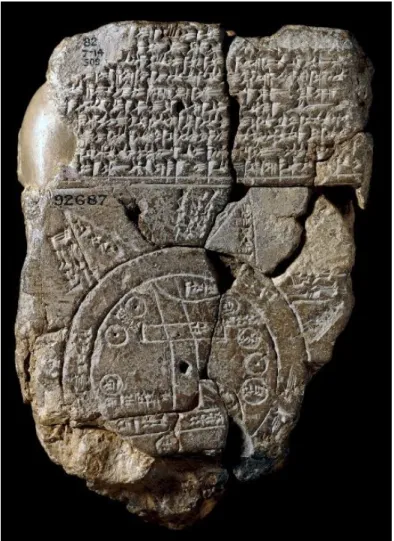
2.4 Babylonian ‘Map of the World’
Another example of a concept common to geography and astronomy is the circle. In several Akkadian literary texts, the term ‘circle (kippatu) of the four winds’ denotes the edge of the known world, which suggests that the Earth was assumed to have a disc-like shape.22The most prominent piece of evidence that this belief was held is the Babylonian
‘Map of the World’,also known as the ‘mappa mundi’,23which is a depiction of the world as known to the Babylonians (see Fig. 1). This map and the descriptions on it do not provide an accurate and complete representation of Mesopotamian geographical knowledge. As Horowitz and Rochberg argue,24it should be regarded as an ideological map with mytho-logical connotations. The tablet’s colophon (the inscription added by a scribe to the end of a text) states that it was copied from an “old exemplar”, but country names such as Assyria, Bit-Yakin, Habban and Urartu indicate that it could not have been created before the ninth century BCE.25The map depicts the Earth as a round continent that is completely surrounded by an ocean (marratu). Originally, eight triangular areas callednagûs, of which only five are preserved owing to the tablet’s damaged lower edge, radiated from the outer circle. The nagûs contain descriptions of faraway regions, with distance measurements expressed inbēru. Interpreting these descriptions poses significant difficulties:26at the top of the circular continent, there is an area labelledˇsadû(‘mountain’), which some scholars believe represents the cardinal direction ‘mountain (wind)’, that is, the east. However, the orientation of the river suggests that the top corresponds to the north or north-west.27 Moreover, neither interpretation can explain the problematic positioning of several of the countries and cities. In short, the mappa mundi is not a world map in the modern sense but an idealized depiction of a disc-shaped Earth, composed in accordance with Babylonian mythological conceptions.
2.5 Coordinates in Babylonian mathematical astronomy
Another Babylonian innovation, which contributed to Greek geographical coordinate systems, was the introduction of the zodiac around 400 BCE. Babylonian astronomers
22 Horowitz 1998, 298. 23 Horowitz 1998, 20.
24 Horowitz 1998; Rochberg 2012.
25 The provenance of the tablet is uncertain, but Sippar and Borsippa are two possibilities (see Horowitz 1998, 26). Although it belongs to a collection in the British Museum that consists mainly of tablets from Sippar, it is possible that the tablet comes from Borsippa, the likely place of origin of the scribe mentioned in the colophon.
26 According to the text, the distances measured were “in between”, which perhaps refers to the distances between neigbouringnagûs. However, why these distances are of importance remains unexplained. On the reverse side of the tablet, we again find some distance values for thenagûs, but they do not correspond to those on the obverse side.
Fig. 1 | Babylonian ‘Map of the World’ (BM 92687). Photograph courtesy of the Trustees of the British Museum.
introduced this new coordinate system in order to express the positions of celestial bodies. They did this by dividing the apparent path of the Sun, that is, the ecliptic circle, into twelve zodiacal signs, each comprising 30 UˇS. Henceforth, the UˇS was used not only to measure time and geographical distance but also to express the positions of celestial bodies and their distances along and perpendicular to the ecliptic,such that 1 UˇS corresponds to 1 (modern) degree (of an angle).28Note that thebēruwas not incorporated into this
coordi-nate system,29which became a central concept of Babylonian mathematical astronomy30
and zodiacal astrology. This coordinate system was transmitted to Greek astronomers no later than the second century BCE, most probably in the writings of Hipparchus and Hypsicles. In the second century CE, Claudius Ptolemy made it an integral part of his astronomical theories and he was probably the first to construct a related system of geographical coordinates.
28 Subdivisions of the UˇS, as indicated by subsequent sexagesimal digits of a distance or position, were not explicitly named, with the exception of 1/60 of a UˇS, which was sometimes called a ‘rod’ (nindanuin Akkadian).
29 One zodiacal sign is equivalent in length to 1bēru, but no explicit mention of this has been found. The bērudoes show up as a distance unit in a few star lists and other unusual astronomical texts, but these distances appear to be the result of mathematical or mythological speculations, since they are very large and incompatible with the angular distances that are expressed in UˇS. For a discussion of these texts, see Schaumberger 1952 and Rochberg-Halton 1983.
To sum up, several concepts related to geographical longitude can be traced back to the coordinate systems, units and definitions of cardinal directions that were developed by Babylonian astronomers. However, other concepts, such as the UˇS unit, unquestionably have their origins in traditional Mesopotamian geography.
3 The concept of longitude in ancient Greek geography
3.1 Aristotle’s picture of the world
Readers of Aristotle’s Meteorologymight be surprised to come across a short discussion about the form of the Earth and the size of the inhabited world right in the middle of a section on the theory of winds. Aristotle (384–322 BCE) succinctly describes how only a small part of the spherical Earth is habitable.31This brief digression is preceded and
fol-lowed by a detailed presentation of the causes, number, names and positions of the winds. As in Mesopotamian sources, wind directions are closely linked with spatial orientations as well as with the picture of the world at that time. The key element of Aristotle’s work, however – and which leads to major ramifications for the development of Hellenistic geography – is his affirmation that the Earth is spherical. His decisive argument, developed inDe caelo, is based solely on his astronomical knowledge:
How else would eclipses of the moon show segments shaped as we see them? As it is, the shapes which the moon itself each month shows are of every kind – straight, gibbous, concave – but in eclipses the outline is always curved; and, since it is the interposition of the earth that makes the eclipse,the form of this line will be caused by the form of the earth’s surface, which is therefore spherical.32
Observing the sky provides invaluable information about the form of the Earth, the shape of the inhabited regions and the location of specific places in the world. Indeed, believing that the Earth is spherical does imply that places, depending on where they lie on the Earth’s surface, are affected by different climates and are subject to different meteorolog-ical conditions. Hence Aristotle believes that theoikoumenē cannot be round. This fact is also confirmed by empirical estimations:
For reason proves that the inhabited region is limited in breadth, while the cli-mate admits of its extending all round the earth. For we meet with no excessive heat or cold in the direction of its length but only in that of its breadth; so that there is nothing to prevent our travelling round the earth unless the extent of the sea presents an obstacle anywhere. The observations made on journeys by sea and land bear this out. They make the length far greater than the breadth. If we compute these voyages and journeys the distance from the Pillars of Heracles to India exceeds that from Aethiopia to Maeotis and the northernmost Scythians by a ratio of more than 5 to 3, as far as such matters admit of accurate statement.33
According to Aristotle,theoikoumenē’s length runs in an east–west direction and its breadth in a north–south direction – a crucial idea for the development of the two concepts of geographical longitude and latitude. Moreover, the Aristotelian picture of the world has another important consequence: depending on the geographical latitude of their location, observers will see differences in the apparent daily motion of the sky. However, if the
31 Arist.Meteor. 2.5 (362b). The two habitable zones lie between the polar circles and the tropics. See Harley and Woodward 1987, 144–145.
observers change their location in an east–west direction, the daily phenomena remain the same. Thus, as it is harder to determine precisely the longitudinal extent of a country or the longitudinal position of a geographical place, ancient geographers needed to de-velop tools and concepts to compensate for or to solve this difficulty. Aristotle does not develop or improve geographical concepts such as meridian and parallel circles,klimata,34
or computable latitude or longitude, but he does link regular astronomical phenomena (such as lunar eclipses and star observations) to geographical representations.
3.2 Parallels, meridians and Hellenistic maps
Dicaearchus (fl. c.326–296 BCE) is commonly credited as being the first scholar to use a meridian and a parallel circle as cartographic descriptive elements, although very little is known about his map of the world.35From the few mentions and fragments of his work,
however, Agathemerus (c.1st/2nd century CE) attributes to him the creation of a straight line, which runs from the Pillars of Hercules (Gibraltar) through Sardinia, Sicily, the Peloponnese, Caria, Lycia, Pamphylia, Cilicia and the Taurus Mountains until the Imaon Mountains in the east (Central Asia), effectively splitting theoikoumenē into two parts: a northern and a southern section.36 We can, therefore, regard Dicaearchus’ line as the
archetype of the parallel through Rhodes, which Eratosthenes (c.276–c.194 BCE) would later define. This fundamental line enables Dicaearchus to arrive at an approximation of the whole length of theoikoumenē, or at least of some of its sections.37
Through his corrections to the ‘old map’38, Eratosthenes develops the concept of
par-allels and meridians, and combines it with the description of the Earth and its inhabited parts. Strabo (c.64/63 BCE–c.21 CE) later reports that Eratosthenes used a meridian that went through Meroe, Syene, Alexandria, Rhodes, Byzantium and the Borysthenes,39in
or-der to measure the circumference of the Earth and the latitudinal extent of theoikoumenē. Hipparchus (c.190–post 126 BCE) corrects some of Eratosthenes’ distance data, but other-wise preserves the latter’s alignment of places on this meridian.40It seems, however, that this line did not play the role of a reference axis, as far as the description of the inhabited world and its parts is concerned. Eratosthenes first divides the map of the known world into two zones (or northern and southern divisions), from the parallel through Rhodes. He then divides each zone into smaller sections, which he callssphragides, and likens each
sphragisto a geometrical figure, so that it can be easily represented on a map.41Thus, here
it is theparallel that plays the role of an axis and divides theoikoumenē into two, just
34 The Greek termκλίμα(pl.κλίματα) means ‘inclination’, referring to the inclination of the pole above the horizon, by which one can determine the latitude of a place.
35 Berger 1903, 367–384; Harley and Woodward 1987, 152–153; Rathmann 2013, 103–104. M. Rathmann also believes that Dicaearchus was responsible for developing the idea of degrees of latitude and longi-tude.
36 This imaginary line is the famousdiaphragma, a term that is frequently used in modern scholarly publications. There is, however, no evidence that Dicaearchus himself used this term. Agathemerus writes of a simple ‘right line’ (Agathem.Hypotyp. 1.5), while Strabo, reporting on the work of Eratosthenes, uses only ‘line’. There are few mentions in antique texts of the termdiaphragmain a geographical context. 37 Dicaearchus estimates, for example, that the distance between the Peloponnese and the Pillars of Hercules
measures 10 000 stadia (Str.Geogr. 2.4.2), which is the first evaluation of the longitudinal extent of this part of the Mediterranean Sea.
38 Str.Geogr. 2.1.2.
39 Str.Geogr. 1.4.1–2. The Borysthenes is the present-day Dnieper River. H. Berger and many modern scholars have tried to attribute the introduction of this main meridian to Dicaearchus, as it is visible on many reconstructions of the ‘Dicearchus map’. See Harley and Woodward 1987, 153. However, despite its plausibility, there is no evidence for this attribution.
40 Str.Geogr. 1.4.1–2.
as in Dicaearchus’ map, thereby providing a useful framework for organizing countries. The role of themeridianthrough Rhodes is less clear, though, and none of the surviving fragments of Eratosthenes’Geographycontains enough evidence to support the idea that the meridian was combined with the parallel in order to arrange thesphragides.42
Even in the much later geographical work of Pliny the Elder (23–79 CE), in which he describes twelve parallel circles, it is clear that a grid of meridians to locate places on the Earth’s surface has still not been developed. In his list, Pliny provides a description of the countries and cities situated under each parallel, from east to west, but he does not mention any meridians.43Consequently, the cities linked to one parallel are spatially
disconnected from the ones of the other circles, so that it is impossible to determine if, for example, Syracuse (under the 3rd parallel) is to the west or to the east of Massilia (under the 6th).
The experiences of navigators played a distinct role in this cartographic concept of places aligned on the same meridian.44 One of the most valuable sources, according to
Eratosthenes, was Timosthenes of Rhodes (fl. c.270 BCE), a navigator and author of a work on harbours,45 who developed a system of spatial orientation based on wind directions
and completed the Aristotelian compass rose.46 According to Strabo, Timosthenes also
referred to some places lying in a north–south direction.47 Therefore, we can reasonably assume that some of the north–south alignments of places used by Eratosthenes were inspired by the work of Timosthenes. The idea of a set of places aligned along a common meridian also prefigures Ptolemy’s systematization of meridians for his world map. It is, therefore, not surprising to see Timosthenes among the very few sources explicitly quoted by Ptolemy (c.90–c.168 CE).48
3.3 A geographical convention
The Greek word commonly used – by Ptolemy among others – to designate the longitude of a place is τὸ μῆκος, which originally referred to the length of an object, that is, an object’s largest dimension compared with its smaller one.49 Therefore, when the term
μῆκοςis used in a geographical text, its meaning relates to the field of geometry.50 When
commenting on thesphragidesof Eratosthenes, Strabo points out that defining the length or breadth of countries that have a complicated geometrical form can be problematic:
The fourth sphragis would be the one composed of Arabia Felix, the Arabian Gulf, all Egypt, and Ethiopia. Of this section, the length [μῆκος] will be the space bounded by two meridian lines, of which lines the one is drawn through the most western point on the section and the other through the most eastern point. Its breadth [πλάτος] will be the space between two parallel lines, of which the one is drawn through the most northern point, and the other through the most southern
42 Although Strabo refers several times to the north–south division of the Eratosthenianoikoumenē(Str. Geogr. 2.1.1; 2.1.21; 2.1.31), he never alludes to a western or an eastern part. Moreover, even if Eratosthenes had used meridian alignments of places to determine, for example, the edges of some of hissphragides(e.g. Str.Geogr. 2.1.39–40), no traces of any systematization of a meridian grid have survived.
43 Pl.Nat. Hist.6.211–220.
44 Ptol.Geogr. 1.4.2. Strabo gives a similar explanation for the Rhodes–Alexandria alignment (Str.Geogr. 2.5.24).
45 Str.Geogr. 2.1.40.
46 Harley and Woodward 1987, 153; Arnaud 2005, 53–59.
47 Such as Massilia (Marseille) and Metagonion (Ras el Ma) in modern-day Morocco (Str.Geogr. 17.3.6). 48 Ptol.Geogr. 1.15.2; 4.
49 EuclidElem. 1 Defs. 2 & 5; Arist.Phys. 4.1 (209a).
point; for in the case of irregular figures whose length and breadth it is impossible to determine by sides, we must in this way determine their size.51
Incidentally, it is Strabo who introduces the idea of alongitudinal extent as opposed to a simplelength. In the context of an oriented space (thanks to the cardinal directions), the word μῆκος designates not the largest dimension of a country but its extent from east to west, whatever the measurements of its dimensions. In order to use this term in that particular way, it is necessary to have an idea not only of the overall shape of a given country but also of its location on the Earth’s surface. It is reasonable to assume that Eratosthenes already formalized this fact in his own work – even if Strabo’s text is unclear on this point.Strabo places this cartographic convention,which was systematically decided upon and is clearly based on the Hellenistic picture of theoikoumenē, into the spotlight:
And, in general, we must assume thatlengthandbreadthare not employed in the same sense of a whole as of a part. On the contrary, in case of a whole the greater distance is calledlength, and the lesser distancebreadth, but, in case of a part, we call
lengthany section of a part that is parallel to the length of the whole – no matter which of the two dimensions is the greater, and no matter if the distance taken in the breadth be greater than the distance taken in the length.
Therefore, since theoikoumenēstretches lengthwise from east to west and breadth-wise from north to south, and since its length is drawn on a line parallel to the equator and its breadth on a meridian line, we must also, in case of the parts, take aslengthsall the sections that are parallel to the length of the inhabited world, and asbreadthsall the sections that are parallel to its breadth.52
By the time of Ptolemy, the assimilation of the termμῆκοςwith the concept of the east– west direction has become well and truly established.53
3.4 From longitudinal intervals to longitudes
With the development of a framework made up of parallels and meridians, the term
μῆκοςacquires over time the modern meaning of thelongitudeof a place. A particularly decisive innovation occurs when a description of places along parallels and the distance data between these places are combined. While Dicaearchus provides distances measured between places that lie on his main parallel,54Eratosthenes, paradoxically, does not link
the parallel through Rhodes to his own distances.55
Artemidorus (fl.c. 100 BCE) remains the major source on this topic in antiquity, being quoted later by Agathemerus, Pliny the Elder (who gives some of his distances), Strabo and Marcian of Heraclea (5th to 6th century CE). Artemidorus’ line is not explicitly presented
51 Str.Geogr. 2.1.32. Transl. H.L. Jones modified. 52 Str.Geogr. 2.1.32. Transl. H.L. Jones modified. 53 Ptol.Alm. 2.1; Ptol.Geogr. 1.6.3–4.
54 For instance, 3,000 stadia from the Peloponnese to Sicily and 7,000 stadia to the Pillars of Hercules (Str. Geogr. 2.4.2).
by Pliny as a parallel circle,56but it does match the Hellenistic parallel of Rhodes: it goes
through the Ganges, the Gulf of Issus, Cyprus, Rhodes, Astypalaia, Lilybaion (Marsala), Caralis (Cagliari), Gades (Cadiz) and the Sacred Cape (Cape St. Vincent in modern-day Portugal). The related distances – 8568 miles from the Ganges to the Gulf of Issus, then 2103 miles to Caralis and 1250 miles to Gades – were, for the most part, used to measure the length of the wholeoikoumenē.
Marinos of Tyre (fl. c.100 CE) improves the concept of meridians and in his work provides some tables of hour-intervals, on the model of the klimata, which should be understood as longitudinal sectors into which places are classified.57 Each zone, which
Marinos numbers, covers a longitudinal interval of 15◦,58 allowing Marinos to locate approximately some places at a longitudinal interval, no matter which parallel circle they occupy. Tables of bothklimataand hours-intervals are, indeed, kept separate in Marinos’ work, and it is clear that he did not use hours as a unit for the absolute longitude of places. Ptolemy, however, found Marinos’ tables unsatisfying,59and the former must be cred-ited for coming up with the idea of taking distances measured along a parallel to deter-mine the longitude of a particular place on Earth. For example, Ptolemy uses the measures established by Marinos of Tyre on the parallel through Rhodes and converts them into degrees, first, like his predecessors, in order to discuss the length of theoikoumenē,60 and then to get individual longitudes for each of the mentioned places. In Ptolemy’s work, the termμῆκοςdesignates not only the length or the longitudinal extent of a country but also the absolutelongitudeof any place, as in our modern understanding.61In order to make this possible, Ptolemy has to fix a prime meridian. He draws the first meridian through the Fortunate Isles (entered in the catalogue of localities of hisGeography), situated at the extreme western point of theoikoumenē, and gives it exactly the same function as today’s Greenwich Meridian:
[By ‘locations’ I mean] the number of degrees (of such as the great circle is 360) in longitude [κατὰ τὸ μῆκος] along the equator between the meridian drawn through the place and the meridian that marks off the western limit [of the
oikoumenē], and the number of degrees in latitude [κατὰ τό πλάτος] between the parallel drawn through the place and the equator [measured] along the merid-ian.62
This specific meaning of the termμῆκος, as well as the idea of a catalogue of localities with both longitudes and latitudes, is certainly inspired by Ptolemy’s astronomical work and his catalogue of stars.63 The influence of astronomy is also clear from the geographical vocabulary he uses. When Ptolemy needs to give an absolute longitude, a particular place always liesundera meridian, and he takes the celestial sphere as the reference point of the location:64
56 Pl.Nat. Hist.. 2.242–243. 57 Ptol.Geogr. 1.15.5. 58 Ptol.Geogr. 1.14.9. 59 Ptol.Geogr. 1.18.4–6. 60 Ptol.Geogr. 1.12.11.
61 Ptolemy was, of course, aware of the polysemy ofμῆκοςin the field of mathematical cartography. When he describes the shape of Ireland (Geogr. 1.11.8), he needs, e.g., to specify “its length [μῆκος]from east to west”, because the largest dimension of this island (itsgeometricallength) is in its north–south direction. 62 Ptol.Geogr. 1.19.2. Transl. J.L. Berggren and A. Jones modified.
63 Ptol.Alm. 7.5–8.1. See Graßhoff 1990, 6–16.
Hipparchus has transmitted to us …lists of the localities that are situated under the same parallel [ὑπὸ τοὺς αὐτοὺς παραλλήλους]; and a few of those who came after him have transmitted some of the localities that areoppositely situated …meaning those that are under a single meridian [ὑπὸ τοὺς αὐτοὺς μεσημβρινούς].65
However, in two cases meridians and parallels are taken to be the projection of celestial lines on the Earth’s surface. On the one hand, when Ptolemy and, with some exceptions, Strabo measure a location’s longitudinal distance, it is alwayson toa parallel circle:
One should follow the number of stades from place to place, set down by Marinos, …as measured onto the parallel [ἐπὶ τοῦ παραλλήλου] through Rhodes.66
It would be adequate …to divide the parallel through Rhodes, on which [ἐφ’ οὗ] most of the investigations of the longitudinal distances have been made, in proportion to the meridian, as Marinos does.67
On the other hand, when a parallel is used to list places from east to west, it always goes
throughthe cities and countries. Strabo writes:
The Sacred Cape …lies approximately on the line that passes through Gades [διὰ Γαδρείρων], the Pillars, the Strait of Sicily and Rhodes.68
And Ptolemy:
In the description of the parallels, Marinos puts the parallel through Byzantium [διὰ Βυζαντίου] through Satala [διὰ Σατάλων] and not through Trapezous [διὰ Τραπεζοῦντος].69
Theon of Alexandria later continues this practice of alternating between the prepositions ‘under’(ὑπό) and ‘on to’(ἐπί), depending on the context.70To sum up, Ptolemy establishes
in theGeographya geographical and cartographic tradition to express the longitudes of places. In order to make it possible for him to find the absolute locations of places any-where on the Earth’s surface, Ptolemy perfects the Hellenistic concept of parallels and meridians by giving the wordμῆκοςa new meaning as well as creating a set of descriptive conventions.
4 The development of methods in Greek geography
Many descriptions of the spatial relationships between distant locations within different conceptual frameworks can be found in ancient Greek texts. However, there exists no detailed information about the methods that were used to determine these relationships. What we do have, though, are some argumentative passages which contain deductions of such values as well as data sets that are the result of ancient geographical practices. In addition, there exist a number of brief statements about the general principles that are said to have been used within the process of determining these values.
Particularly with regard to the argumentative textual passages, the only sources that can be fruitfully analysed are theGeōgraphiká of Strabo (c.64/63 BCE–c.21 CE), in which the author summarizes and discusses some of the arguments of Eratosthenes (c.276–c.194
65 Ptol.Geogr. 1.4.2. Transl. J.L. Berggren and A. Jones modified. 66 Ptol.Geogr. 1.11.2. Transl. J.L. Berggren and A. Jones modified. 67 Ptol.Geogr. 1.21.2. Transl. J.L. Berggren and A. Jones modified. 68 Str.Geogr. 2.5.14. Transl. H.L. Jones.
69 Ptol.Geogr. 1.15.9. Transl. J.L. Berggren and A. Jones.
BCE) and Hipparchus (c.190–post 126 BCE),71and theGeography72of Ptolemy (c.90–c.168
CE). There is also a dearth of sources about the methods that concurred with certain conceptual developments, of which we are aware through what is known about the geo-graphical work of Artemidorus (fl. c.100 BCE) and Marinos of Tyre (fl. c.100 CE).
4.1 Path distances, the Earth’s circumference and longitudinal
relationships
Questions pertaining to longitudinal relationships are an intrinsic part of Eratosthenes’ approach to geography in which he describes the oikoumenē by means of sections and
sphragides, particularly when determining their metrical properties and orientations. For example, Strabo’s description of Eratosthenes’ third section of the oikoumenē starts by specifying its eastern, northern, western and southern sides. Strabo construes some of these sides in terms of natural linear features, such as the Euphrates River, which is used as its western side, but, as in the case of the southern side, they do not necessarily correspond to any natural outline of the landscape:
[T]he Persian Gulf breaks into the southern side, as Eratosthenes himself says, and therefore he has been forced to take the line beginning at Babylon as though it were a straight line running through Susa and Persepolis to the frontiers of Carmania and Persis, on which he was able to find a measured highway, which was slightly more than nine thousand stadia long, all told. This side Eratosthenes calls ‘southern,’ but he does not call it parallel to the northern side.73
All in all, the remaining fragments show that, at least in the words of Strabo, Eratosthenes’ system of describing the world is much more abstract than a figurative description of the shapes of parts of countries. In addition, even though terms such as the ‘southern side’ or ‘northern side’ (which could be read to mean sides that are parallel to each other and that run from east to west) are employed and countries are described using geometrical forms, Strabo states on more than one occasion that they should be taken to be solely general descriptions. So, if in this context some distances are defined in the east–west direction, these orientations are more or less the result of chance.
If Strabo is right about how he says Eratosthenes arrived at the dimensions of these geometrical figures, the text shows at least one way of determining them: in the case of the third section, they come from taking measurements of the distances along the lines that were used as the sides of this figure. Furthermore, the discussion of the western side (which is determined by the Euphrates), in particular, suggests that no additional methods were used to cancel out the elongations that arose from using the lengths of non-straight pathways rather than the direct distances between places. Owing to the lack of sources, it is impossible to establish whether the same applies to Eratosthenes’ determination of the longitudinal extent of the wholeoikoumenē.
In sum, this means that distances that run in an east–west direction neither describe the longitudinal distance between two places nor the longitudinal extent of an area, and nothing is known about how Eratosthenes determined such values, if he ever did so. Additionally, his representation of the world using the concept ofsphragides, as presented by Strabo, has much in common with the description of the provinces found in the so-called cadastre of Ur-Nammu.74
71 Especially Str.Geogr.2.1. 72 Especially Ptol.Geogr.1.
73 Str.Geogr.2.1.23. Transl. H.L. Jones.
A B A'
B'
Earth
great arc
of the sky Fig. 2 | Illustration of the methods attributed to Eratosthenes to determine the Earth’s circumference.
However, according to several ancient Greek and Roman authors, Erastosthenes used the knowledge he had about equal longitudinal positions of places far distant from the main parallel to determine the circumference of the Earth using a procedure that is attributed to him. Although there are almost as many different versions of what Eratosthenes did as there are reports about it,75 and despite the different intentions of those descriptions, all share a common principle: owing to the sphericity of the Earth and its position at the centre of the universe, the ratio of an arc on the celestial sphere to a full great circle equals the ratio of the direct distance between two placesAandBlying on the surface of the Earth beneath the two end pointsA0andB0of the aforementioned arc to the whole circumference of the Earth (Fig. 2). Even though the method, as described by Ptolemy more than 300 years later in hisGeography,76works for direct distances in any direction, the
sources agree that Eratosthenes evaluated a situation in which he is said to have believed that a pair of localities (Alexandria and Syene, according to Cleomedes, and Syene and Meroe, according to Martianus Capella) lay along the same meridian. In the case of this special spatial relationship between the localities, one has to know the length of a portion of a celestian meridian circle. Unlike the case of arcs oriented in arbitrary directions in the sky, the length of this arc can be derived either from solely knowing the geographical latitudes of the two places or from other, equivalent information. The sources name a large number of astronomical phenomena, methods and instruments that can be useful in this respect – even though it is by no means clear what Eratosthenes in actual fact did. In contrast to the descriptions of methods for determining latitudinal differences, there is not a single indication in any of the reports – even in the more didactic of the ancient texts – that explains how Eratosthenes determined which places were located on the same meridian.
It is not evident to what extent the views of Hipparchus differ from Eratosthenes with regard to concepts and terminology. At the very least, Hipparchus’ treatise,Against the
75 Extensive descriptions of his method can be found in CleomedesOn the Circular Motions of the Celestial Bodies1.7. Other sources are: VitruviusDe Architectura1.6.9; PlinyNat. Hist.2.247; CensorinusDe Die Natali13.2; and Martianus Capella 6.596–598.
Geography of Eratosthenes, as handed down through Strabo, reveals a completely different way of thinking about spatial relationships and the dimensions of the world.
According to Strabo, Hipparchus, within his critique of Eratosthenes’ description of the world, derived some distances from the information handed down by Eratosthenes. For example, he argues:
[S]ince the northern side of the Third Section is about ten thousand stadia, and since the line parallel thereto, straight from Babylon to the eastern side, was reck-oned by Eratosthenes at slightly more than nine thousand stadia, it is clear that Babylon is not much more than a thousand stadia farther east than the passage at Thapsacus.77
Such derived data provided the basis for further calculations:
[I]f we conceive a straight line drawn from Thapsacus towards the south and a line perpendicular to it from Babylon, we will have a right-angled triangle, composed of the side that extends from Thapsacus to Babylon, of the perpendicular drawn from Babylon to the meridian line through Thapsacus, and of the meridian itself through Thapsacus. Of this triangle he makes the line from Thapsacus to Babylon the hypotenuse, which he says is four thousand eight hundred stadia; and the per-pendicular from Babylon to the meridian line through Thapsacus, slightly more than a thousand stadia – the amount by which the line to Thapsacus exceeded the line up to Babylon; and then from these sums he figures the other of the two lines which form the right angle to be many times longer than the said perpendicular.78 On the basis of these considerations, Hipparchus deduced the latitudinal difference be-tween Babylon and Thapsacus.
On the whole, Hipparchus used geometrical calculations, based on some given data, to deduce the properties of the spatial relationship between places. However, it is not clear from the extant parts of his text whether he made any adjustments to allow for the sphericity of the Earth. By introducing purely abstract geometrical figures, whose sides lie in an east–west or a north–south direction, Hipparchus, in the surviving fragments of his work, for the very first time systematically considered the longitudinal and latitudinal aspects of the position of a locality separately and gave a quantitative description of the positions of places relative to abstract lines,that is,lines that do not correspond to naturally occurring linear features such as rivers, shorelines and mountains.
However, all these calculations and considerations make up Hipparchus’ criticism of Eratosthenes’ description of the world. According to Strabo, Hipparchus’ main argument consisted of drawing conclusions from Eratosthenes’ data and showing that this leads to contradictions. Whereas it is clear that Hipparchus believed that this was an appropriate way of justifying his criticisms, there is no indication that such calculations were really meant to determine the spatial relationships of places on the Earth’s surface. This, too, is attested by Strabo, who rebuked Hipparchus several times for failing to provide any corrections to his criticisms of Erastosthenes’ work.79
Ptolemy’s criticism of how Marinos of Tyre determined the longitudinal extent of the world should be read in a similar way: Ptolemy estimated the longitudinal differences between pairs of places along the coastline of India by calculating the east–west aspect of the distances of sea journeys in a multi-step procedure that included reducing distances to account for elongations arising from the shapes of coastlines and from non-straight
sea journeys, thereby arriving at direct distances. When carrying out the calculation, he also considered the effects of the Earth’s spherical shape, until he finally devised a way of representing the result by incorporating the distances between the meridian lines of the localities into a great circle.80 However, even though Ptolemy set out the calculation
with explanations of all its intermediate steps very clearly, this is not the method he used to derive his own longitudinal positions in hisGeography. As he himself explained, such calculations only served to justify his criticism of Marinos’ value of the longitudinal extent of theoikoumenē.
Byzantion
Tenedos
Chios
Rhodes M=141
2 h M=143
4 h M=15 h M=151 4 h
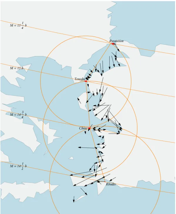
Fig. 3 | Reconstruction of the method used by Ptolemy for determining the positions of places on the west coast of Asia Minor in hisGeography.
What Ptolemy did in fact do to obtain the positions of places was make a geometrical construction on a plane map (Fig. 3). For example, on the western coast of Asia Minor, the positions of three locations that served as the starting points for finding the locations of other places were constructed successively, beginning at the island of Rhodes. The position of the next location, the island of Chios, was derived from its latitude and its distance from Rhodes. Whereas the latitudinal aspect of its position was given by the parallel of the place, which corresponds to a circle on the map, the location itself was determined by drawing a circle around Rhodes with the given distance between the two islands as the radius. This circle took the place of the actual, slightly egg-shaped curve on which localities with that distance from Rhodes lie on a map with Ptolemy’s map projection. However, if errors are made in the latitude or in the direct distances, as in the case of the position of Byzantium, this method can lead to the introduction of large inaccuracies in the longitudinal relationships.81
As we have seen, the methods referred to in the argumentation for and against single statements on spatial relationships and found as explanations of the ancient transmitted geographical data made extensive use of distances, which were given instadia(‘stades’), of latitudinal data and of the size of the Earth’s circumference. Methods that are known from astronomy also become part of the geographical toolbox, particularly where the two latter types of data are concerned. This emergence of astronomical methods in geography can be traced back to the time of Eratosthenes or earlier. The size of the Earth is crucial when determining the relative positions of localities or countries in the procedures identified above. Differing values for the circumference of the Earth, as found in the texts of ancient geographers, not only mean that a distance measured between two places corresponds to different portions of a great circle of the Earth; owing to the spherical shape of the Earth, variations in the resulting figures are generated from the combinations of distances and directions on that sphere, too. As in the case of Ptolemy’s construction of the coordinates of theGeography, this would also affect the shapes of coastlines, countries and the relative positions of localities. So, the varying values for the Earth’s circumference that were held by the ancient Greek geographers is a problematic factor of these methods, and recognised as such by the ancient scholars.82
4.2 Determining longitudinal distances without the aid of surveys
All the methods for determining the longitudinal relationships mentioned in the sources that explicate general principles are related to the field of astronomy. In the three extant cases detailed below, knowledge about longitudinal relationships was derived solely from observing eclipses:
1. According to Strabo, Hipparchus – in his treatiseAgainst the Geography of Eratosthenes
– explains that a knowledge of astronomy is essential for dealing appropriately with geographical topics. One of his reasons is that “we cannot decide accurately whether places are situated to a greater or less degree towards the east or west except by comparison of [the times of] eclipses of the sun and moon”.83
2. In hisAlmagest, Ptolemy explains why the known parts of the world cover a quarter of the Earth, stating that this area is bounded by the equator in the south and a great circle through the poles:
In the case of longitude (that is, in the east–west direction) the main proof is that observations of the same eclipse (especially a lunar eclipse) by those at the extreme western and extreme eastern regions of our part of the inhabited world (which occur at the same [absolute] time), never are earlier or later by more than twelve equinoctial hours [in local time]; and the quarter [of the Earth] contains a twelve-hour interval in longitude, since it is bounded by one of the two halves of the equator.84
Besides the reasoning, the whole statement about the size and position of the oik-oumenēcan be traced back to Hipparchus.
3. In hisGeography, Ptolemy informs his readers about the general quality of the avail-able geographical data, which was based on astronomical observations:
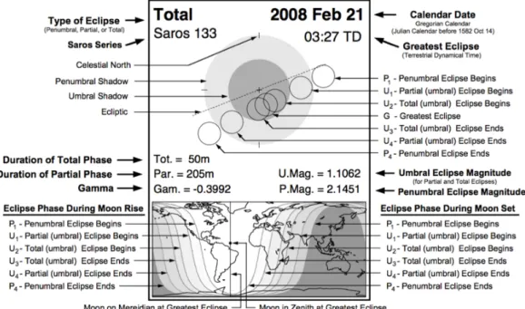
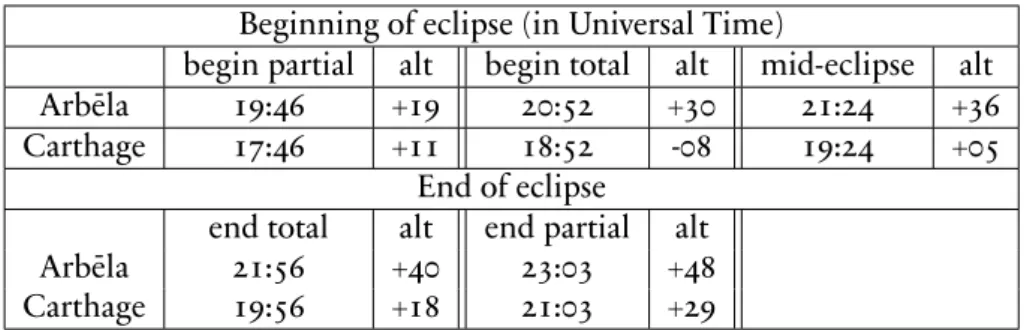
Most intervals, however, and especially those to the east or west, have been re-ported in a cruder manner, not because those who undertook the researches were careless, but perhaps because it was not yet understood how useful the more mathematical mode of investigation is, and because no one bothered to record more lunar eclipses that were observed simultaneously at different localities (such as the one that was seen at Arbēla at the fifth hour and at Carthage at the second hour), from which it would have been clear how many equinoctial time units separated the localities to the east or west.85
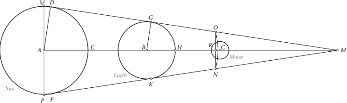
Eclipses play a central role in all three of the above sources. Explanations of lunar and solar eclipses as the effects of two special constellations of the Sun, Moon and Earth appear in extant Greek texts that can be traced back to long before Ptolemy and Hipparchus. Solar eclipses occur when the Sun, Moon and Earth are aligned, with the Moon lying between the Sun and and the Earth (we say that the Moon is in conjunction with the Sun). In lunar eclipses, the three celestial bodies are again aligned, this time with the Earth situated between the Sun and the Moon (we say that the Moon is in opposition to the Sun). Geometrical representations of this model can also be found in ancient Greek sources: for example,inOn the sizes and distances of the sun and moon86from the third century BCE, Aristarchus uses the geometry of both phenomena to determine the dimensions of the celestial bodies (Fig. 4).
A Q
P
E B H R C M
D
G
O
F
K
N
Sun
Earth
Moon
Fig. 4 | Diagram based on the geometrical explanation of lunar eclipses as used in Aristarchus’On the sizes and distances of the sun and moon, proposition 15.
The general principle of Ptolemy’s method of determining the longitudinal difference between two places as described in the Geography can be explained as follows: if it is possible to observe a lunar eclipse from two different places, the same event – the shadow of the Earth falling on the Moon – will be visible simultaneously from both places. This means that the lunar eclipse is an indicator of one and the same moment for all localities on the moon-facing side of the Earth. Through observing the local time,87as in the example of Arbēla and Carthage, at a defined moment of an eclipse, it is possible to calculate the time differences in equinoctial hours between two places, which is equivalent to a longitudinal difference.
Besides all their similarities, there are some fundamental differences between the three texts on determining longitudinal relationships:
– Whereas texts 1 and 3 refer at least to the existence of methods to dermine the spatial relationships between places, text 2 contains a statement about lunar and solar eclipses and its consequences for determining the longitudinal extent of the world.
– The results of these methods differ: in the method described in 3, one reaches an absolute value of the difference in equinoctial hours between two places, while 1 leads to a statement about which place lies more westerly or easterly, and it is not clear if the result includes a quantitative value of the difference.
– Ptolemy emphasizes that both the procedure in text 3 and the statement about the longitudinal extent of theoikoumenē in text 2 are based on comparisons of obser-vations of the same eclipses. Strabo provides no such information for Hipparchus’ procedure in text 1. Furthermore, it is not made at all clear what exactly should be observed, particularly in texts 1 and 2: the statement on the time difference also does not imply that one has to record the local times of eclipses.
– The procedure in text 3 is restricted to the usage of lunar eclipses, whereas in text 1 Strabo explicitly mentions solar eclipses. The addition of “especially a lunar eclipse” in text 2 also implies that there was at least one other type of eclipse that could be used.
Although texts 1 and 2 are unclear and differ from Ptolemy’s statement in theGeography, they may still – at least with regard to lunar eclipses – relate to the same principle.
Even though the geometrical model of lunar eclipses is probably in some way part of the reasoning of his method, Ptolemy does not propose a geometrical procedure in theGeography: his text clearly suggests that one should carry out a calculation. However, what is more important than considering a specific geometrical situation is the fact that a lunar eclipse is simultaneously visible from different places on the Earth. This, too, had been known from at least the 1st century BCE, when Geminus wrote in hisIntroduction to the Phenomena:
The eclipses of the Moon are, however, equal for all [observers]. For the coverings that occur in the eclipses of the Sun are different on account of the locations [of the observers], for which reason the magnitudes of the eclipses are different. But the Moon’s falling into the shadow is equal for all during the same eclipse.88
87 The passage does not make clear exactly what should be observed or what kind of data needed to be documented; the recording of local times fits Ptolemy’s specific example, but there are equivalent data that could have been recorded, such as the culminations of stars (see section 6).
Geminus contrasts this property of lunar eclipses with the characteristics of solar eclipses. He describes the spatial relationship of the celestial bodies and the variations in the phe-nomena, which he explains is a result of the different perspectives of the Sun and the Moon for observers at different locations:
The eclipses of the Sun occur because of covering by the Moon. Since the Sun moves higher, and the Moon lower, when the Sun and the Moon are at the same degree, the Moon, having run in under the Sun, blocks the rays leading from the Sun toward us. Therefore, one must not speak of them as eclipses in the proper sense, but rather as coverings. For not one part of the Sun will ever be eclipsed [i.e., ‘fail’]: it [simply] becomes invisible to us through the covering of the Moon. For this reason the eclipses are not equal for all [observers]; rather, there are great variations in the magnitudes of the eclipses, in accordance with the differences of the klimata. For at the same time the whole Sun is eclipsed for some, half [is eclipsed] for others, less than half for others, while for still others no part of the Sun is observed to have been eclipsed at all. For those dwelling vertically beneath the covering, the whole Sun is invisible; for those dwelling partly outside the covering, a certain part of the Sun is seen to have been eclipsed; and for those dwelling wholly outside the covering not one part of the Sun is observed to have been eclipsed.89
Since Ptolemy’s description of eclipses in hisAlmagestis very similar, we can be confident that he was familiar with these characteristics.
As a consequence, solar eclipses cannot be used as indicators of exactly the same moment for different places on the Earth. So, replacing observations of lunar eclipses with observations of solar eclipses in the method that is explained in theGeographywill not lead to the correct results. Provided that it was the simultaneous occurrence of lunar eclipses that led to Ptolemy’s method, we have to assume that he was aware of this consequence. This tallies with the text: his method explicitly uses lunar eclipses.
It is not easy to explain why Strabo, citing Hipparchus in text 1, and Ptolemy in text 2 both refer to solar eclipses. Of course, they may have just made a mistake –- Hipparchus, or Strabo, might simply have been wrong about solar eclipses, and perhaps Ptolemy’s addition of “especially a lunar eclipse” in theAlmagestwas a gentle way of pointing out Hipparchus’ error. It is also possible that the errors occurred later during the process of transmission of the various texts. However, it is striking that the reference to solar eclipses as a useful data source coincides with the determinations of more general statements about the east–west relationship between two places and not with the determinations of their absolute distance. But whether Ptolemy and Hipparchus had considered any particular method of doing so using solar eclipses is simply not known.
4.3 Problem solved?
Hipparchus and Ptolemy agreed that the best way of determining longitudinal differ-ences, both absolutely and in comparison with other methods, was to evaluate observa-tions of eclipses, a method they described as being exact (ἀκριβής)90and based on
unques-tionable (ἀδίστακτος)91 sources. According to Strabo, Hipparchus even demonstrated that it was not possible to determine these values using any other procedures.92Ptolemy
89 Gem.Phaen.5.1–5. Transl. J. Evans and J.L. Berggren. 90 Str.Geogr.1.1.12.