HOSTILE GROUND: TERRAIN, FORCE, AND CONTROL
IN THE ROMAN EMPIRE
Gabriel Moss
A dissertation submitted to the faculty at the University of North Carolina at Chapel Hill in partial fulfillment of the requirements for the degree of Doctor of Philosophy in the
Department of History.
Chapel Hill 2020
Approved by:
Richard Talbert
Wayne Lee
Jon Lendon
Fred Naiden
ii © 2020 Gabriel Moss
iii ABSTRACT
Gabriel Moss: Hostile Ground: Terrain, Force, and Control in the Roman Empire (Under the direction of Richard Talbert)
This dissertation fuses traditional military history and modern Geographic Information
Systems (GIS) technology to study the relationship between terrain, military force, and imperial
control in the Roman world. Drawing on ancient authors’ general antipathy towards warfare on
“broken ground,” I argue that Rome’s army struggled to wage war efficiently and effectively in
mountainous territory. Using GIS technology and open-access data developed by natural
scientists, we can map such rugged terrain in the ancient world on a larger scale than ever before,
and integrate military topography into broader discussions of imperial power dynamics.
The dissertation offers three case studies which demonstrate the potential use of GIS
analysis for histories of Roman imperialism. The first, on the Spanish wars of the late 3rd and early 2nd century BCE, considers how rugged terrain shaped Rome’s conquest of foreign
territory. While Rome was initially hesitant to extend its forces into the Iberian highlands, it was
compelled to adjust its strategy when the concentration of force in river valleys and coastal
plains failed to quell widespread resistance in the hills. The second case study examines the
Jewish revolt between 66 and 73 CE, in which the defensive terrain of Judaea and Galilee helped
turn local discontent into outright rebellion. The third and final case study reconstructs the
Romans’ northeastern frontier during the first two centuries CE, considering how Rome
deployed its garrisons in response to the challenges of the eastern Anatolian mountains. In this
iv
intermittent, large-scale warfare with the Parthians—and the necessity of addressing small-scale,
endemic brigandage within the frontier zone.
Overall, this dissertation highlights Rome’s fundamental pragmatism in response to
environmental challenges; the longevity of Rome’s rule depended, to a large extent, on its
willingness to balance the costs and rewards of imperial control, and to govern by compromise
where it could not efficiently dominate by force. The dissertation also suggests the importance
of GIS tools and training within the historian’s toolkit, and outlines a flexible methodology for
vi
ACKNOWLEDGEMENTS
This dissertation would not have been possible without the support of numerous people.
Thanks are due, first and foremost, to my advisor Richard Talbert, who guided me through
graduate school with kindness and humor. I could not have asked for a better mentor. Jon
Lendon went above and beyond the call of duty in providing advice and support throughout the
writing process, and the dissertation has benefited tremendously from his knowledge and
generosity. Wayne Lee, Thomas Parker, and Fred Naiden all provided valuable feedback on
drafts, and their perceptive input on the dissertation prospectus helped set this project on a
workable path.
I am grateful for the support of the UNC Digital Innovation Lab (whose Digital
Dissertation Fellowship supported research in Summer 2018), as well as the university’s Ancient
World Mapping Center and Digital History Lab. Ryan Horne and Philip McDaniel provided GIS
support at crucial junctures. My thanks as well to my many colleagues in the UNC History
Department who have provided advice and commiseration over the years: I was lucky to land in
so collegial an environment.
I would like to thank my friends and family for their love and encouragement. I thank
my writing partner, Max, for his company and support. Finally, I thank my wonderful wife,
vii
ABBREVIATIONS AND TRANSLATIONS
viii
TABLE OF CONTENTS
LIST OF FIGURES.………... x
LIST OF MAPS……… xi
LIST OF TABLES……… xiii
INTRODUCTION………. 1
Section One: Force, Control, and Military Imperialism……… 2
Section Two: Space and the Environment………. 6
Section Three: Locating Broken Ground: GIS and Historical Geography……….. 9
Section Four: Structure and Argument……….. 12
CHAPTER ONE: BROKEN GROUND AND ROMAN WARFARE………. 17
Section One: “Descending to the Plain” and Roman Ideas of the Battlefield……… 24
Section Two: Broken Ground, Heavy Infantry, and the Roman Way of War………... 31
Section Three: Home Field Advantage: Broken Ground and Evening the Odds……… 40
Section Four: Refuge: Broken Ground, Survival, and Imperial Control……… 56
Conclusion………... 68
CHAPTER TWO: TAKING CONTROL: BROKEN GROUND IN THE ROMAN CONQUEST OF SPAIN (218-179 BCE)……… 70
ix
Section Two: The Spanish Front During the Second Punic War
(218-206 BCE)……….. 82
Section Three: The First Generation of Roman Spain (205-179)………. 106
Section Four: Sequels and Implications……… 121
CHAPTER THREE: LOSING CONTROL: TERRAIN AND RESISTANCE IN THE FIRST JEWISH REVOLT (66-73 CE)………... 141
Section One: Beth Horon and the Topographical Advantages of Jerusalem………... 147
Section Two: The War in Galilee……….. 160
Conclusion………. 176
CHAPTER FOUR: HOLDING CONTROL: THE ROMAN FRONTIER IN EASTERN ASIA MINOR………... 187
Section One: The Historical Development and Strategic Context of the Northeastern Frontier………... 193
Section Two: The Geography of the Northeastern Frontier...………... 210
Sector One: Samosata to Melitene………. 214
Sector Two: Melitene to Zimara……… 227
Sector Three: Zimara-Nicopolis-Satala………. 231
Sector Four: Satala to Trapezus………. 242
Section Three: The Purpose of the Northeastern Frontier……… 248
CONCLUSION……….. 287
x
LIST OF FIGURES
xi
LIST OF MAPS
Map 2.1: Spain TRI Overview……….. 127
Map 2.2: Spain Elevation Overview………. 128
Map 2.3: Carthaginian Force Projection, 237-218 BCE………... 129
Map 2.4: Roman Force Projection, 218-211 BCE……… 130
Map 2.5: Roman Force Projection, 210-206 BCE……… 131
Map 2.6: Roman Force Projection, 205-190 BCE……… 132
Map 2.7: Roman Force Projection, 189-179 BCE……… 133
Map 3.1: Cestius Gallus’ March Towards Jerusalem………... 179
Map 3.2: Cestius Gallus’ Retreat From Jerusalem………... 180
Map 3.3: Judaean Plateau TRI Overview………. 181
Map 3.4: Least-Cost Path Analysis of Cestius Gallus’ March………. 182
Map 3.5: Josephus’ Centers of Jewish Resistance in Galilee………... 183
Map 3.6: Notable Sites Omitted from Josephus’ Fortification List………. 184
Map 4.1: Northeastern Frontier TRI Overview……… 256
Map 4.2: Sector One TRI……….. 257
Map 4.3: Sector One TRI (Generalized)………... 258
Map 4.4: Sector One Elevation………. 259
Map 4.5: Sector One Viewshed……… 260
Map 4.6: Alternative Routes and Local Strongholds in Sector One………. 261
Map 4.7: Sector Two TRI………. 262
Map 4.8: Sector Two TRI (Generalized)……….. 263
xii
Map 4.10: Sector Two Viewshed……….. 265
Map 4.11: Sector Three TRI………. 266
Map 4.12: Sector Three TRI (Generalized)……….. 267
Map 4.13: Sector Three Elevation……… 268
Map 4.14: Sector Three Viewshed….………... 269
Map 4.15: Sector Three Schematic………... 270
Map 4.16: Least-Cost Path Analysis of Sector Three………... 271
Map 4.17: Sector Four TRI………... 272
Map 4.18: Sector Four TRI (Generalized)……… 273
Map 4.19: Sector Four Elevation……….. 274
Map 4.20: Sector Four Viewshed………. 275
Map 4.21: Slope and Agricultural Suitability, Sectors One and Two……….. 276
Map 4.22: Slope and Agricultural Suitability, Sectors Three and Four……… 277
Map 4.23: Modern Ground Cover, Sectors One and Two……… 278
xiii
LIST OF TABLES
Table 2.1: Sites of Carthaginian Force Projection, 237-218 BCE……… 134
Table 2.2: Regions of Carthaginian Force Projection, 237-218 BCE………... 134
Table 2.3: Sites of Roman Force Projection, 218-211 BCE………. 135
Table 2.4: Regions of Roman Force Projection, 218-211 BCE……… 135
Table 2.5: Sites of Roman Force Projection, 210-206 BCE………. 136
Table 2.6: Regions of Roman Force Projection, 210-206 BCE……… 136
Table 2.7: Sites of Roman Force Projection, 205-190 BCE………. 137
Table 2.8: Regions of Roman Force Projection, 205-190 BCE……….... 138
Table 2.9: Sites of Roman Force Projection, 189-179 BCE………. 139
Table 2.10: Regions of Roman Force Projection, 189-179 BCE……….. 139
Table 2.11: TRI Averages by Period……… 140
Table 3.1: Josephus’ Centers of Jewish Resistance in Galilee………. 185
Table 3.2: TRI Statistics for Centers of Jewish Resistance in Galilee……….. 185
Table 3.3: TRI Statistics for Sites Omitted from Josephus’ Centers of Jewish Resistance in Galilee………. 186
Table 4.1: Sector One Sites TRI and Elevation……… 280
Table 4.2: Sector One Routes TRI and Elevation………. 281
Table 4.3: Sector Two Sites TRI and Elevation………... 282
Table 4.4: Sector Two Routes TRI and Elevation……… 282
Table 4.5: Sector Three Sites TRI and Elevation………. 283
Table 4.6: Sector Three Routes TRI and Elevation……….. 284
xiv
Table 4.8: Sector Four Sites TRI and Elevation………... 285
1
INTRODUCTION
At its core, this dissertation is a study of power and space in the Roman world.
Combining traditional techniques of ancient history with modern tools of digital mapping and
Geographic Information Systems (GIS), it explores the spatial settings of Roman imperialism,
asking how the depth and nature of empire shifted with the physical landscape. This inquiry
reveals the Romans as deeply pragmatic practitioners of power, whatever their rhetoric of
boundless imperium. While Rome’s capacity for violent conquest and political control was seldom matched in the pre-modern world, it was not limitless, and the success and endurance of
the empire depended in part on the willingness of imperial leaders to compromise their ambitions
in the face of environmental obstacles.
In its most basic form, the dissertation’s central argument can be expressed as a logical
syllogism:
1. Rome’s ability to control territory rested in large measure on military force: that is, the
threat and exercise of violence by armed agents of the state.
2. Certain types of terrain, most notably mountains, hills, and other topographically broken
ground, hampered the ability of Roman armies to exercise violence efficiently (and, by
extension, to threaten it credibly).1
1 While this dissertation will focus primarily on the ways in which rugged terrain raised the probable costs
2
3. Therefore, broken ground shaped Rome’s ability to control territory, and in consequence
the dynamics of Roman imperialism on rugged terrain were distinctly different from how
they were in the plains. The empire’s control over hilly and mountainous space was often
tenuous, and rested more on cooperation than forcible coercion.
We may thus use the physical landscape of the ancient world (as reconstructed by modern GIS
technology) as a lens to analyze the priorities and possibilities of military imperialism. By
examining the environmental challenges of Roman warfare, we can learn something new and
valuable about the empire that this warfare helped to create.
Section One: Force, Control, and Military Imperialism
While each of the following chapters touches on its own historical and historiographical
issues, this introduction sets out the basic context and methodological principles that inform the
dissertation as a whole. Before turning to the potentially less-familiar realm of historical GIS, let
us begin by framing the first principle of my argument, that Rome’s control over its empire was
won and held, in large part, through military force. To start, this claim’s central concepts—force
and control—must be defined, because they will continue to underlie the discussion of Roman
warfare and imperialism.
By “control,” I refer to the ability of the Roman state to command the obedience of a
given territory’s inhabitants; to make its people do what Rome wanted (or, perhaps more
frequently, not to do what Rome did not want).2 The term is roughly equivalent to “power” in
2 Except where questions of internal disunity matter, I typically discuss Rome in this dissertation as a
3
much of the scholarship on Roman imperialism: William Harris, in his ambitious Roman Power, bemoans the term’s ill-defined ubiquity, but uses it nevertheless.3 The Romans themselves would have expressed “control” as imperium, the right to command (though for our purposes the term need have no connotations of legitimacy or legality).4
As a category of analysis, control exists independently of any specific policy ends.
Whatever Rome’s imperial goals in a territory—acculturation, taxation, slaughter, or mere peace
and quiet—control was a necessary precondition for success. In isolation, therefore, more
expansive and intensive control was always desirable for both practical and ideological purposes,
and imperium sine fine was a certainly a cornerstone of Roman political thought.5 As the case studies here will demonstrate, however, controlling space and its inhabitants was an expensive
proposition. While Roman authors were not always willing to admit it, the empire calculated the
costs it was willing to bear to control a given territory based on the likely political and economic
rewards. Roman imperialism was thus shaped by a tension between an ideological will to power
and the practical recognition that total control was impossible; resources and power had to be
carefully managed in order to align the geography of control with the empire’s political goals.
nuances of imperial decision-making (see for instance Millar 1977, Talbert 1984), it allows a clearer focus on the power dynamics between Rome and its foreign subjects. See discussion in Morley 2010, 22-23.
3 Harris 2016, 1. “Control” both better captures the my meaning here, and avoids entanglement in the
many previous uses of “power.” Among others, see Luttwak 1976 (esp. 195-200); Landers 2003 (esp. 8-12), who also uses “spatial integration” as a rough synonym; Morris and Scheidel 2009; Ando and Richardson 2017.
4 Richardson 2008. Cic. Inv. Rhet. 2.169 gives potentia as a value-neutral alternative: “power is the
possession of things suitable to keep what is your own, and to take what belongs to others.” (potentia est
ad sua conservanda et alterius adtenuanda idonearum rerum facultas.)
5 Verg. Aen. 1.279, and see Lintott 1981. On distinctions between intensive and extensive control, see
4
If control was the necessary precursor to any of the various forms of Roman domination,
“force” was a crucial tool in achieving this goal. Drawing heavily on Edward Luttwak, I define
force as the ability of the armed agents of the Roman state to inflict violence—crudely put, to kill
people and destroy their possessions—and, crucially, to credibly threaten to do so.6 Military force thus has two distinct but related components: active force (a “wasting resource” consumed
in its use through the necessary casualties of even successful warfare) and threatened force,
which may generate control through the fear of destruction.7 As Luttwak correctly stresses, the latter variety of force is more important in the efficient maintenance of empire; indeed, he
identifies power (my “control”) as obedience caused by the fearful perception of force.8
To be sure, violence and the fear thereof are not the only factors which generated control
in the Roman world; Michael Mann’s influential The Sources of Social Power identifies military force as just one of four building blocks of state authority (along with ideological, economic, and
political power).9 This dissertation gives more attention to force than other sources of control because force, alone among the tools of the Roman state, was unilateral.10 If we consider Mann’s other forms of power in the Roman context—the acculturation of provincials; the
creation of legitimate governing rules and institutions; outright bribery—all required a degree of
local consent, a willingness of imperial subjects to accept the ideological and material “benefits”
6 Luttwak 1976, 195-200.
7 For an unusually direct description of the dynamics of force, threats, and fear: Onas. 6.11. Cf. Lee 2020,
which discusses the closely related concept of “latent” force.
8 Luttwak 1976, 197-98. For a quite different definition of power, and a thorough review of earlier
theoretical literature on the subject, see Arendt 1970.
9 Mann 1986, 1.1-33. See also Mann 1984. Mann’s other sources of social power feature more heavily in
Ando and Richardson 2017; Monson and Scheidel 2015.
5
of empire in exchange for their compliance. Force worked differently. The fear of death and,
failing that, the realities of destruction, were the final bulwark of imperial authority, and violence
the last guarantor of Roman control.
This structural outline of force and control paints an admittedly bleak picture of life under
the Romans. In narrowing our focus to the military dynamics of Roman imperialism, we should
not forget that other varieties of social power were constantly in play; in many cases, Rome’s
control over its subjects was based on more than terror alone. At the same time, this was a
violent world, both socially and politically; as Greg Woolf argues, the ideology of the Pax Romana concealed a wide variety of anti-imperial warfare both on and behind the Roman frontiers.11 Banditry was endemic: even if latrones themselves lacked a coherent political
program, their existence was an affront to ideals of imperial order, and policing was an important
task of the Roman military.12 Indeed, the size and expense of the Roman army in the imperial period speak to the importance of force in maintaining the emperors’ rule. Rome did not
maintain hundreds of thousands of soldiers idly.13 Military force, the army’s ability to commit and threaten violence, was a crucial pillar supporting imperial control.
11 On social violence: Fagan 2011. On political violence: MacMullen 1966; Dyson 1971; Woolf 2002;
Gambash 2015.
12 Shaw 1984; Fuhrmann 2012.
13 For select contributions on the grand strategy debate, discussed further in Chapter Four: Luttwak 1976;
6
Section Two: Space and the Environment
With these definitions of force and control in mind, let us consider the impact of space on
Roman imperialism. For this subject, John Landers’ The Field and the Forge provides an important methodological starting point. In this ambitious work, Landers explores “the effects
that western economies' reliance on organic sources of energy and raw materials had on the
spatial organization of human activities,” and particularly on the imposition of state control, from
the development of agriculture to the industrial revolution.14 Landers stresses the importance of “demographic space,” a conception of geography that emphasizes the relationship between
human activity and the longue durée material constraints of the pre-industrial world.15 The attempts of states to exert control over the world, to integrate space into cohesive, interdependent
units, relied heavily on the supply and movement of resources (caloric energy being the most
important in the ancient case). Centuries of statecraft and state-building can thus be envisioned
as an attempt to balance the benefits of control with the costs of pacification and resource
extraction.
Landers provides an important model for thinking through the relationship between force,
control, and space in the ancient world: as he stresses, the mechanics of power are intimately
rooted in their physical settings, and cannot be properly understood in isolation from the natural
environment. Violence, after all, is an intensely physical affair. Although scholars since the late
20th century have admirably broadened their scope of inquiry to the cultural, social, and
intellectual features of military life, combat (as Adrian Goldsworthy argues) remained the most
14 Landers 2003, 1.
15 Landers 2003, 5-6. Landers draws this intellectual framework from the Annalistes, most notably
7
important role of the Roman army, and the material, technological, and environmental conditions
of warfare exerted a profound influence on its nature and success.16
That said, The Field and the Forge is generally more interested in economic than military history, though its emphasis on the material conditions of power is naturally useful for the study
of ancient warfare as a tool of state control. Recent work by Wayne Lee applies Landers’
concepts more directly to warfare, and shares this dissertation’s interest in analyzing military
activity within its physical and ecological context.17 Lee focuses on the range of possible means for conquerors to solidify their control over captured territory, given the ability of the
environment to support its occupiers logistically and to reward them economically and
politically. This dissertation remains alert to these factors: mountains could present harrowing
challenges to ancient logistics, and were typically less lucrative spaces for imperial control.
However, I dedicate more attention to the limits which topography placed on the direct
imposition and re-imposition of control through violence, and I end to emphasize tactical and
operational factors more than strategic ones.
Drawing on the models of Landers and Lee, let us return to the second proposition of my
opening syllogism, that all space was not created equal for the purposes of Roman control.
Thinking in terms of “demographic space,” certain geographies of economic resources were
more difficult for the Romans to exploit, to the point that targeting these resources for imperial
16 Goldsworthy 1996, esp. 1-11. Goldsworthy draws this methodology from Keegan 1976 (and cf.
Hanson 1989). Among numerous works relying on the physicality and environmental setting of ancient warfare: Kromayer and Veith 1903-1931; Cary 1949; Engels 1978; Hughes 1994; Shean 1996; Erdkamp
1998; Roth 1999. For a broader overview of late 20th and early 21st century military historiography, see
Citino 2007.
8
control might not be worth the effort. In the more traditional language of military geography (for
which Donald Engels’ Alexander the Great and the Logistics of the Macedonian Army is foundational to the study of the ancient world) certain types of environments made it physically
more difficult for the Romans to project and enact military force, and thus to exercise political
control.18 Landers encapsulates how these two factors could come together to impede effective imperial authority: “logistical and other constraints...made it almost impossible to maintain a
controlling presence in thinly populated areas with difficult terrain. Whatever constitutional or
ideological fictions might be maintained, remoter areas of forest, hills, or moorland were prone
to slip outside the effective control of central or regional authorities..."19
This dissertation is interested in exactly these sorts of spaces and the dynamics of
violence and imperialism within them, and in particular in hills, mountains, and otherwise
“broken ground.”20 As Chapter One argues more fully, we know that the Romans were
traditionally uncomfortable fighting in such areas, and for good reason. By examining these
peripheral spaces of military force and political control, we can uncover patterns in both local
resistance and Roman priorities, as the empire negotiated power relationships on hostile ground.
However, in order to integrate the physical environment properly into narratives of Roman
imperial warfare, we need to be able to characterize, analyze, and “think with” terrain. The
careful employment of GIS technology allows us to do exactly that.
18 Engels 1978.
19 Landers 2003, 265, and see 250-74.
20 While forests and marshlands presented similar obstacles to Roman control (see McNeill 2004; Tucker
9
Section Three: Locating Broken Ground: GIS and Historical Geography
Historical geography, in both its traditional and digital manifestations, is composed of
two sub-fields: cultural and physical geography. While closely related, each has its own sets of
resources and challenges. When it comes to cultural geography and locating the settlements and
structures of the ancient world, this project benefits from over thirty years of sustained progress
in mapping Greco-Roman civilization. Locational data has long been important in Classics,
especially on the archaeological side of the field, and works such as Kennedy and Riley’s
Rome’s Desert Frontier from the Air demonstrate the rewards of geospatial ancient studies.21 Yet despite ambitious projects such as the Tabula Imperii Romani, a modern reference atlas for the ancient world remained unavailable until the release of the Barrington Atlas in 2000.22 Subsequent work by the Pleiades Project and the Ancient World Mapping Center at the
University of North Carolina has both expanded on the Barrington data and made it digitally available for use in GIS platforms.23 As a result, scholars today have better and more readily available resources than ever before to understand the configurations of human space in Rome‘s
world, and the cultural-geographic side of this dissertation draws extensively on datasets already
developed for classical studies.24
21 Kennedy and Riley 1990.
22 Talbert 2000. See further: Bagnall 1980, 27; Talbert 1992; 2018.
23 Ancient World Mapping Center: <awmc.unc.edu>. Pleaides: <pleiades.stoa.org>. I have served as
Director of AWMC and Co-Managing Editor of Pleiades, and maintain active ties with both organizations.
24 Other important contributions in ancient geospatial digital humanities include Stanford’s Orbis
10
We enter less well-trodden territory when it comes to physical geography, particularly
when it comes to the use of digital tools to evaluate the topographical backdrop to ancient
society. These tools and the datasets they produce were developed by the modern scientific
community for the solution of distinctly modern problems; modifying them to our ends is thus a
necessarily messy and imperfect process. When it comes to rugged terrain, however, the basics
are reasonably simple. Broken ground, in quantitative terms, can be defined by variation in
elevation: areas where elevation varies widely over a relatively small area are more “broken”
than those where elevation is more constant. The first step in building a GIS model of broken
ground is therefore a Digital Elevation Model (DEM), a dataset which associates points on the
earth’s surface with their elevation above sea-level. This dissertation relies on a DEM known as
SRTM-90: elevations were measured by sophisticated radar equipment on NASA’s Shuttle
Radar Topography Mission in February 2000, with a data resolution of approximately 90 m (that
is, 90 x 90 m grid squares on the Earth’s surface are assigned a single elevation value).25 This
resolution is detailed enough to capture the ruggedness of the landscape accurately, but not so
detailed as to be skewed by terrain changes caused by modern construction.
From our elevation dataset, we can use a variety of GIS techniques to determine a given
area’s degree of local elevation variation, the “broken-ness” of the ground.26 For our purposes,
25 Farr et al. 2007. The data used here was processed by the Consortium for Spatial Information and is
available for download at < https://cgiarcsi.community/data/srtm-90m-digital-elevation-database-v4-1>. On CSI’s processing methods, see: Reuter 2007. SRTM-90 data, along with a wide variety of other DEMs and geospatial datasets, can also be downloaded from the US Geological Survey’s EROS Data Center (<https://eros.usgs.gov>).
26 For an excellent and well-sourced survey of the various mathematical approaches to broken ground,
along with helpful tutorials on performing them using GIS software: Cooley, S.W. “Terrain Roughness:
13 Ways.” GIS 4 Geomorphology. 2016.
11
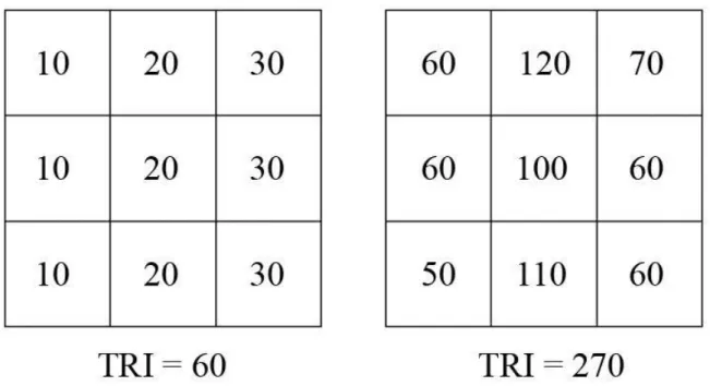
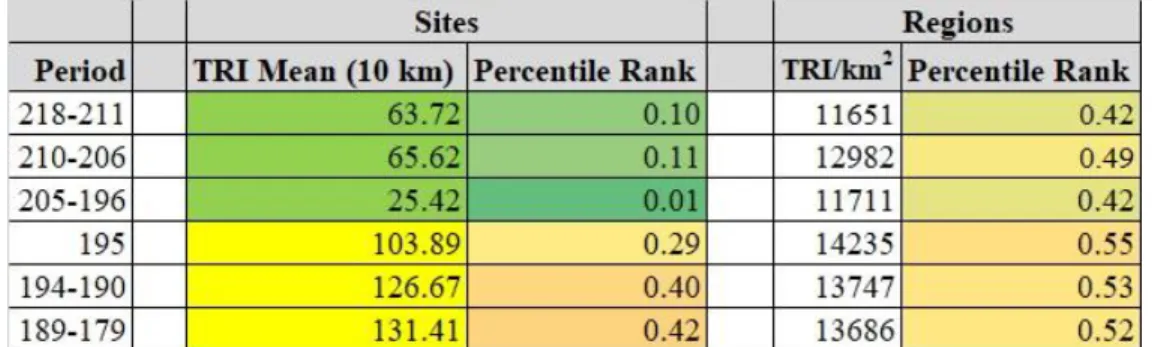
the most useful metric is the Terrain Roughness Index (TRI). This statistic, originally developed
for ecological research but applied more recently in the social sciences, is defined as the total
difference in elevation between a central grid-square and the eight squares surrounding it.27 Figure 1 shows two examples of TRI calculation; the example on the right is quantifiably more
rugged than that on the left.28
In combination, the SRTM-90 digital elevation model and TRI processing provide a
quantitative measure for the ruggedness of terrain almost anywhere on Earth. Correlating TRI
statistics with their probable impact on the Roman army is somewhat harder. Judging by
historical comparanda and personal experimentation, it seems likely that TRI values between 100
and 200 m would have started to affect Roman military performance.29 However, we cannot state with absolute confidence how broken the ground had to be for it to affect military
performance in the way we see throughout Greco-Roman military literature; there is certainly no
single TRI value below which Roman forces could always operate easily and above which they
could not. The physics of campaign and combat are multivariable, and TRI statistics are
predictive but never determinative. As a result, TRI figures are best used comparatively. Even if
we cannot pinpoint the correlation between TRI and military performance, we can still use this
metric to think through local variations in imperial power relationships.
27 Riley et al. 1999. For social-scientific applications see: Jimenez-Ayora and Ulubasoglu 2015; Nunn
and Puga 2012.
28 All figures, maps, and tables in this dissertation are located at the end of their respective chapters.
29 For instance, Gettysburg’s famous Round Top hills have TRI values between 110-120 m. Just outside
12
TRI analysis forms the methodological bedrock of Chapters Two through Four; in
combination with other techniques of digital geography and data processing, it allows us to bring
questions of space and terrain to the forefront of military history in a way that was
technologically impracticable before the 21st century. At the same time, historical GIS does not always overcome the fundamental difficulties of ancient geography: where our traditional
sources fail, technology is no panacea, and, all too frequently, we simply cannot locate a town,
tribe, or battle. This dissertation champions the inclusion of GIS among the many tools of the
historical profession (and the beginning of Chapter Two outlines some ways that digital methods
can accommodate uncertain and ambiguous data better than their analog predecessors). Yet at
the same time, it remains necessary to temper the enthusiasm of the digital humanities with the
traditional rigor of ancient studies. This dissertation seeks to turn technology on those questions
it can answer, and to openly acknowledge those it cannot.
Section Four: Structure and Argument
The dissertation’s organization roughly follows the three clauses of the syllogism laid out
above. Thus far, I have asserted the (relatively uncontroversial) opening proposition and defined
the crucial terms of power and control (along with outlining a GIS methodology for the analysis
of military terrain). Chapter One draws on ancient literary evidence to defend the syllogism’s
second proposition. Analyzing the topoi of Roman battle narratives, it reconstructs a set of perceptions and preferences concerning combat on broken ground, a cultural discourse shared by
Roman authors and their social peers in command of the army. In this military mindset, broken
ground was typically an unsuitable environment for combat. Ancient authors believed that rough
13
particularly in the foreign wars of conquest and counterinsurgency that subjected the
Mediterranean world to imperial authority.
The remaining three chapters explore the syllogism’s conclusion and implications,
presenting a series of case studies on different aspects of Roman control. Chapter Two examines
the initial imposition of control through conquest, analyzing the geography of Rome’s Spanish
campaigns between 218 and 179 BCE. It argues that while Roman behavior in these wars
reflected the same distaste for hill- and mountain-warfare which we see in Chapter Two’s literary
portrait, the Romans were capable of adaptation; over two generations of warfare, the geographic
foci of Roman operations shifted upcountry, from the coastal plains and river valleys to the more
challenging environments of the Spanish foothills and mountains. Exploring the Roman
conquest of Spain with questions of space and the physical environment firmly in mind, and with
the assistance of GIS mapping and statistical analysis, Chapter Two thus gives new insights into
how Roman deployment in the Iberian peninsula responded to a shifting strategic environment.
Chapter Three studies the failure and rejection of Roman control through rebellion,
taking as its subject the well-documented Jewish Revolt of the first century CE. Here, GIS
brings new perspectives to the military geography of Judaea during the opening months of the
revolt, giving the most direct evidence that broken ground incubated resistance against Roman
authority. Considering the military geography of Cestius Gallus’ disaster at Beth Horon and the
disposition of Josephus’ strongholds in the Galilee, we see how provincial malcontents shared
Rome’s perception that broken ground opened opportunities for successful local insurgency.
The hopes which some Jews placed in such defensive terrain helps explain local decisions
14
Chapter Four considers the long-term maintenance of Roman control through garrisoning
and frontier policy, exploring the layout of the Roman frontier in eastern Asia Minor in the first
and second centuries CE. As in Chapter Two, GIS analysis reveals a fundamental tension
between two missions: large-scale warfare against rival empires (in this case the Parthians, in
Chapter Two the Carthaginians) and small-scale counterinsurgency and policing actions against
the locals themselves. And as in Chapter Two, we see both a general Roman preference for the
former mission (and the level ground on which it was typically carried out) and a degree of
strategic flexibility: when pressed, the empire extended its garrisons up the Anatolian mountains,
accepting the risks it saw as inherent to such terrain. Though similar in some of its conclusions
to my investigation of Rome’s Spanish wars, Chapter Four considers a larger area and a much
longer stretch of time, and draws on material evidence as much as literary, taking as its basis
Timothy Mitford’s monumental survey of the Upper Euphrates frontier.30 At this spatial and
temporal scale, GIS analysis sheds light not only on the decision-making of individual Roman
commanders, but also on the hotly-debated nature and purpose of the imperial frontier system
over the course of generations.
Taken together, these case studies remind us, on the one hand, that the Romans remained
vulnerable to the structures and strictures of the natural environment, even as they possessed
military capabilities surpassing those of any of their neighbors. For all that the Romans might
push the “limits of the possible” in exceptional displays of concentrated force, their authority
remained dependent on quotidian, cost-effective military action. In literary perception and
military reality, broken ground made such operations more difficult and less desirable, shifting
15
the strategic dynamics of imperial control to the benefit of Rome’s restive subjects and
neighbors.31
On the other hand, these case studies depict the Romans as careful, calculating wielders
of power: the strength and duration of Roman rule depended in part on a more flexible
conception of control than appears in imperial panegyric and self-promotion. In the many
rugged regions of the Roman world, the empire thrived thanks not only to its capacity for
successful violence, but also to the flexibility with which it ruled mountaineers who could not be
dominated by force alone.
16
17
CHAPTER ONE
BROKEN GROUND AND ROMAN WARFARE
If pressed, most historians of Roman warfare would recognize the empire’s anxieties
about combat on mountainous, hilly, or otherwise topographically “broken” ground.1 Concern with such spaces forms a background hum in our sources, and the impact of topography on
military success was well understood during the Roman period: Polybius hypothesized that “in
the majority of land and sea battles in a war defeat is due to difference of position.”2 Centuries later, Vegetius wrote, “the good general should know that a large part of victory depends on the
actual place in which the battle is to be fought.”3 There is certainly an awareness in modern scholarship, especially in the older “battle histories” of the 19th and 20th centuries, that high
ground and defiles could shape the outcome of ancient combat.4 Meanwhile the 20th and 21st century debacles of the United States and USSR in Afghanistan have reaffirmed, for professional
1 As noted in the Introduction, terrain could also be “broken” by vegetation and hydrological factors.
While in many cases such features would have similar effects on Roman military performance as rugged terrain, I exclude them here both in the interests of space and because of the difficulties inherent in mapping ancient ecology and hydrology with modern data.
2 Polyb. 5.21: ἐπεὶ γὰρ τῶν κατὰ πόλεμον κινδύνων τοὺς πλείους καὶ κατὰ γῆν καὶ κατὰ θάλατταν
σφάλλουσιν αἱ τῶν τόπων διαφοραί.
3 Veg. Mil. 3.13: Bonum ducem conuenit nosse magnam partem uictoriae ipsum locum, in quo
dimicandum est, possidere.
4 See, among others, Napoleon III 1866; Du Picq 1880; Stoffel 1890; Delbrück 1900; Kromayer and
18
and recreational historians alike, the importance of environmental obstacles to conquest and
control.
That said, the systematic, structural impact of terrain on Roman violence and control has
not yet received a great deal of intensive study.5 Fernand Braudel opens his classic The Mediterranean and the Mediterranean World in the Age of Philip II with a discussion of mountains in the region’s longue durée history, characterizing them as a world apart from the more “civilized” plains.6 In a passing comment on the ancient world, he draws conclusions similar to this chapter on the depth of Rome’s control over the Mediterranean highlands: “even
Rome itself, in all its years of power, can have meant very little [in the mountains], except
perhaps through the military camps that the empire established for security reasons in various
places on the edges of unconquered mountain lands.”7 Yet Braudel does not particularly explain his observation of imperial authority’s fragility on rugged terrain. There is a certain
trans-historicism to his work (particularly in the early chapters that form much of the basis for the field
of historical geography): this is simply the way that mountains were.
Forty years later, Brent Shaw picked up the theme of montane imperialism in a trio of
outstanding articles on ancient Cilicia-Isauria and Mauretania Tingitana, the closest direct
parallels to what I attempt in this dissertation.8 Developing Braudel’s observations more fully,
5 Despite its promising title, Syme 1988 (“The Subjugation of Mountainous Zones”) is primarily
concerned with more limited questions of Augustan Spain.
6 Braudel 1995 (orig. 1949), 25-43
7 Braudel 1995 (orig. 1949), 34. Trans. Siân Reynolds. As we will see in Chapter Four, this statement
undervalues the degree of Roman penetration into mountainous regions.
19
Shaw argues that mountains in the ancient world were spaces of imperfect imperial authority;
rugged space was ruled loosely, and through inter-personal contacts rather than the more
enduring structures of state power. His explanation for this phenomenon hinges on the limited
technological capacity of ancient states: “the impact of mountain terrain was decisive in a
pre-modern world where the technological forces of domination were inadequate to the task of
controlling this type of topography.”9 Yet Shaw, like Braudel, does not explore these
unspecified “technological forces of domination” at any length. Moreover, his analysis is limited
by a complete lack of maps connecting the structures of Roman control to Isaurian and
Mauretanian geography on anything more than a general level. His work deserves tremendous
praise, but leaves important questions unanswered.
My goal here is to explore more rigorously the impact of physical topography on Roman
imperialism, and to push back on the trans-historical assumption that the Romans dealt with and
thought about hills and mountains in a “timeless” way, divorced from their particular cultural
and military circumstances. While there are certainly commonalities between the Romans’
approach to mountain warfare and those of comparable empires—the physical realities of rough
terrain shaped the range of available tactical and strategic responses—this chapter seeks to
outline the relationship between broken ground and military force in the Romans’ own eyes.
The ultimate target of my analysis is Rome’s “way of doing business” on rough terrain, a
culturally ingrained set of ideas and preferences about warfare and the physical environment.
Rooted in both the physical nature of ancient battlefields and Roman military tradition, this
discourse of combat on rough terrain (to borrow theoretical language from John Lynn) helped to
20
shape the course of Roman warfare and the geography of empire.10 While flexible in its application over time and space, Rome’s basic modus cogitandi for broken ground formed a crucial strategic backdrop to the conquest and rule of mountainous regions. By exploring how
the Romans thought about broken ground, we may thus lay the foundations for later chapters’
case studies of how they acted over it.
When we survey ancient military literature, it becomes evident that Roman commanders,
given the choice, generally did not like to wage war on rough terrain. Ancient authors—either
military men themselves, or members of a shared literary and cultural milieu with Roman commanders—believed with good reason that rugged terrain made Rome’s army worse at
combat, while increasing the enemy’s chances of victory (or, at the very least, of surviving to
fight another day). The political result of this dynamic, in the vision of our sources, was that
imperial control in hills and mountains tended to be shallow and tenuous, if it existed at all. In
short, we should identify the Roman army itself as key among the “forces of domination” cited
by Shaw.
***
Before substantiating these claims of Roman antipathy to combat on broken ground and
its political results, it remains to discuss briefly some matters of historiography and
methodology, outlining general principles for how to handle literary evidence on ancient combat.
In its attempt to understand the mechanics of the Roman army as a fighting institution,
this chapter shares much in common with Adrian Goldsworthy’s influential The Roman Army at
10 Lynn 2003, 331-41. On the ways in which Rome’s memory of its distant military past shaped the
21
War.11 Along with numerous other scholars (all drawing to greater or lesser extent on John Keegan’s Face of Battle), Goldsworthy revived scholarly attention on combat as the defining purpose of the Roman army.12 While Goldsworthy makes little mention of terrain and the physical environment, his goal, like my own, is to reconstruct “how the [Roman] army actually
worked on campaign,” how physics and psychology shaped its functioning as a tool of state
violence.13
Goldsworthy’s work is ambitious and thoroughly researched, and his goals are laudable
(even if I disagree with him on certain points of both substance and methodology). Yet he has
been rightly criticized for an overly credulous approach to ancient literary evidence: in short, for
taking what our sources say as unproblematic representations of the way combat actually
worked.14 The distinctive Greco-Roman methods for writing about battles did not necessarily match their ways of fighting them, and while ancient combat narratives remained tethered to
military fact, we must be careful in this case not to conflate representation and reality. Thus,
while I share Goldsworthy’s interest in the mechanics of Roman warfare, the analysis in this
chapter relies on a different methodology, one that emphasizes the importance of literary topoi in
11 Goldsworthy 1996. Goldsworthy responded to an alternative, socio-cultural historiography, best
represented a decade later in Southern 2006.
12 Keegan 1976. Keegan’s methodology made a controversial entrance to ancient studies with Hanson
1989. For the mechanics and experience of combat in the Roman world, see Lee 1996; Lloyd 1996;
Gilliver 1999; Sabin 2000; along with Wheeler 1979, less indebted than the others to the Face of Battle
school.
13 Goldsworthy 1996, 11.
14 See in particular Catherine Gilliver’s review in Greece and Rome 45.2 (1998) 230-31. Though
Gilliver’s own The Roman Art of War (1999) is somewhat better in this respect, her analysis similarly
22
historical analysis and the connection (but not necessarily the equivalence) between the discourse
and reality of Roman warfare.
Even when our ancient authors know of what they speak in military affairs—an open
question in some cases—they do not always care to depict the realities of warfare accurately in
their prose.15 As J.E. Lendon persuasively argues, battle narratives in ancient texts are heavily shaped by literary convention, “products as much of culture as of observation.”16 For any given battle, our sources blend what actually happened with what (to ancient habits of thought) was
supposed to happen, rendering our evidence a strange mixture of historical fact with stock
narratives, archetypes, and topoi.17 Recognition of the extent to which ancient military narratives were cultural products threatens to sweep the feet from beneath traditional histories of Roman
warfare. In the absence of archaeological corroboration—occasionally available at such famous
sites as Masada, Numantia, and Kalkriese—we cannot securely reconstruct the tactical ebb and
flow of any individual battle or the operational dynamics of any given campaign.
However, for understanding the structural and systematic factors that shaped the military
performance and political impact of the Roman empire, the embeddedness of ancient military
narratives within cultural and literary traditions is a benefit, not a hindrance. As Lendon writes,
“the way ancient authors describe the details of battle can tell us about the mental rigging of the
15 For an example of disagreement over an author’s basic military knowledge, see the debate over Livy,
with the condemnation of him as a military historian in Walsh 1958 (and cf. Walsh 1961), and rebuttals in Roth 2006 and Koon 2010, who give more charitable evaluations of his historical quality.
16 Lendon 1999, 274. Cf. Lendon 2017a; 2017b.
23
societies in which they lived.”18 Topoi of combat, in short, reveal a great deal about ancient culture, values, and habits of mind.19 Of particular interest in this chapter are the set of “rules” for broken ground shared by the writers of Roman military literature (and, we should suspect, by
their social peers commanding Roman armies): a common set of assumptions about the ways
rough terrain affected military operations and preferences about how the empire should best
approach these spaces.20 Thus, while the bulk of this chapter’s evidence comes from Roman battle narratives, our analytical target is not these battles as historical events, but as cultural
constructs demonstrating Rome’s mindset towards broken ground.
Reconstruction of the Roman perception of rough terrain combat, as revealed in the topoi and internal logic of ancient battle narratives, matters in more than the philological abstract.
Romans’ habits of writing and thinking about warfare on broken ground both reflected and
shaped their habits of actually fighting over such terrain. While not necessarily accurate for the
specific battle narratives in which authors deploy them, topoi surrounding the dangers of defile ambushes, the difficulties of assaulting hilltop citadels, and the near-impossibility of corralling
mountaineers into open combat reflect real facts of Roman military experience.21 Such stock descriptions resonate with a Roman audience precisely because they match the readers’ actual
experiences and understanding of combat. At the same time, shared cultural conceptions and
18 Lendon 1999, 275. Cf. Koon 2010.
19 This methodology underlies Lendon 2005.
20 These are referred to in places as “general truths” (rather than details specific to any particular battle) in
Lendon 2017a and 2017b. van Gils, de Jong, and Kroon 2019 casts this distinction in terms of specific “historicity” versus generalized “realism.” On the class-connection of Roman literary figures and political decision-makers, see Mattern 1999.
24
“rules” of warfare shaped the practices of the Roman army. The idea of mountain combat’s
difficulties and risks disinclined Roman commanders to engage on such terrain in the first place,
and mental frameworks thus made themselves felt in military reality. To return to John Lynn’s
theoretical framework, the discourse and reality of Roman warfare existed in an interdependent
and reciprocal relationship.22 We can thus use the literary structures of Roman military discourse, encapsulated in the topoi of ancient authors, to reflect on the real-world, systematic relationship between Roman force and the physical terrain.
Let us turn, then, to reconstruct the Roman understanding of combat on broken ground as
reflected in ancient military literature. We must begin with the strong current of discontent and
anxiety that underlies descriptions of rough terrain and combat: in brief, with the Roman
preconception that rough terrain was fundamentally undesirable as a space for military activity.
Section One: “Descending to the Plain” and Roman Ideas of the Battlefield
In the view of ancient authors, battles should be fought (at least by default) on the plains.
This is not to dispute that the Romans could triumph on rugged terrain (as in Livy’s account of
the victories over Philip V at the River Aous or over Antiochus III at Thermopylae).23 Nor do our sources deny that the Romans themselves at times took advantage of broken ground,
especially when outmatched by the enemy: in Livy’s heavily mythologized account of the Gallic
sack of Rome in 390 BCE, it is only a redoubt on the Capitoline hill that preserves the city from
22 Lynn 2003, 331-341.
25
complete annihilation.24 Yet on the whole, ancient authors display a marked discomfort with Roman military activity on rough terrain (indeed, whatever its tactical impact in practice, Livy
emphasizes the broken ground at Aous and Thermopylae to magnify his Roman heroes’
achievements in the face of adversity). As we will see below, this attitude was occasionally
made explicit, but is most noticeably encapsulated in a common topos of Roman military literature in which armies descend to level ground in order to signal their willingness to fight.
Our sources are rarely forthright when it comes to the systemic relationship between
rough terrain and military efficiency. Within the genre constraints of Roman military literature,
they hardly could be; we have no ancient handbooks on the practical mechanics of warfare, in
the vein of the modern US Army Field Manuals. Yet an antipathy to broken ground comes to the
surface in the campfire banter of soldiers on the march. Tacitus’ legionaries in Britain cast the
island’s rolling landscape as their enemy, bragging of their victories over “the recesses of forests
and mountains” without reference to any human opponent.25 Caesar has his troops express a similar sentiment during the Gallic Wars, as the men claim “that they were not afraid of the
enemy, but feared the narrow passages and vast forests which lay between themselves and
Ariovistus.”26 As Lendon notes, Caesar frequently refers to rugged terrain as locus iniquus, an “unfair” or “unfavorable place.”27 The same motifs appear in Livy, as he describes the Roman
24 Livy, 5.43. Polyb. 18.22 implies that the rugged field of Cynoscephalae put the Romans at an
advantage against Philip V’s ponderous phalanx.
25 Tac. Agr. 25: ac modo silvarum ac montium profunda. See also 17, 33.
26 Caes. BGall. 1.39: non se hostem vereri, sed angustias itineris et magnitudinem silvarum quae
intercederent inter ipsos atque Ariovistum,…timere dicebant.
26
march towards Pydna in 168 BCE: “although the foe threatened [the Romans] from no direction,
the roughness of the terrain harassed them like an enemy.28
A leery discomfort with warfare on broken ground similarly underlies the strategic logic
which our sources impute to Roman commanders. Narrating a Roman campaign against the Boi
in 196 BCE, Livy explains how a Roman consul chose to withdraw along a longer route in order
to avoid broken ground: “he led the army back by the same way he had come, and after a long
roundabout march through country that was open, and therefore safe, he reached his
colleague.”29 Caesar reports that he was willing to tolerate similar delay in order to avoid the risks of rough terrain.30 Similarly, when his men were eager to launch an uphill assault against Avaricum in 52 BCE, “Caesar pointed out what great loss, in the death of so many gallant men, a
victory must necessarily cost,” and refused to attack.31 Later, chiding his men for recklessness, Caesar reminds them that at Avaricum “he had given up an assured victory in order that even
slight loss in action might not be caused by unfavorable ground.”32
More common in ancient literature than explicit critique of broken ground is praise for
plains as the natural spaces of military activity. Livy writes of a battleground in Celtiberia that
28 Livy, 44.5: cum ab nulla parte hostis terruisset, locorum asperitas hostiliter vexavit.
29 Livy, 33.37: exercitum eadem via qua adduxerat reduxit et magno circuitu per aperta eoque tuta loca
ad collegam pervenit. See also 34.28.
30 Caes. BGall. 1.41. For a similar decision, see 6.34. Livy excoriates the Roman commander Manlius
for failing to take such precautions and risking his army on broken ground in Thrace (35.28, 38.46).
31 Caes. BGall. 7.19: Caesar…quanto detrimento et quot virorum fortium morte necesse sit constare
victoriam.
32 Caes. BGall. 7.52: exploratam victoriam dimisisset, ne parvum modo detrimentum in contentione
27
“the plain was entirely flat and suitable for fighting.”33 Appian similarly praises the terrain near Philippi: “the plain was admirably situated for fighting.”34 According to Tacitus, Germanicus
sought to contradict his troops’ preference for level terrain, admonishing them (contrary to the
evident stereotype) that “plains were not the only battlefield favorable to a Roman soldier.”35
Roman preferences and perceptions about “suitable” spaces for combat are encapsulated
in a common topos, in which our authors use a commander’s choice to take up a position on level ground as a symbol for confident belligerence. When armies “go down to the plain” in
ancient military literature, this action is synonymous with their willingness to attempt a decisive
battle. Thus in Appian, both Hannibal and the Romans signaled their readiness for the Battle of
Cannae when “both armies came down to the plain.”36 Livy is even more explicit when describing the Second Punic War in Spain: “as though by agreement, the signal for battle was
raised on both sides, and with all their forces they went down into the plain.”37 The same topos appears even in Plutarch—hardly our most militarily knowledgeable author, but attuned
nevertheless to the perils of hill-combat—as well as in Polybius’ accounts of the first and second
Punic wars.38
33 Livy, 40.30: Campus erat planus omnis et aptus pugnae. See also 38.3.
34 App. BCiv. 4.13.106: τὸ πεδίον ἦν ἐναγωνίσασθαι καλὸν.
35 Tac. Ann. 2.14: non campos modo militi Romano ad proelium bonos. See also 2.5.
36 App. Hann. 4.19: κατέβαινον ἐς τὸ πεδίον ἑκάτεροι.
37 Livy, 23.29: velut ex composito utrimque signum pugnae propositum est atque omnibus copiis in
campum descensum. See also 22.24, 22.30, 24.14, 25.33, 30.8.
28
In an inversion of this topos, one side signals its lack of confidence by refusing to give battle on the plains. According to Appian, Antony and Octavian tried in vain to incite combat at
Philippi, and saw cowardice in their enemies’ mountaintop fortifications. Appian’s account of
Antony’s speech to the troops reflects his own understanding of combat’s spatial logic: “It is the
clearest proof of their defeat yesterday and of their lack of courage that, like those who have
been vanquished in public games, they keep out of the arena…. they do not accept our challenge
and come down from the mountain, but trust to their rocky fastnesses instead of their arms.”39 Livy similarly uses hills and plains as metonyms, standing in for timidity and courage in war:
when Metellus took the field against Hannibal: “the consul…pitched camp near Numistro, in
sight of Hannibal on level ground, while the Carthaginian held a hill. [Metellus] added the
further appearance of confidence in being the first to lead out into battle-line.”40 At the same time, confidence could be misplaced, and Appian criticizes Curio’s leadership in the Civil Wars
when he “very imprudently led his enfeebled army down to the plain.”41
The symbolic logic of the “descent to the plains” topos was not restricted to the Romans; at least in the vision of Roman authors, it was commonly understood in the Mediterranean world
that level fields were the natural site for combat. In Livy’s (essentially fictitious) representation
of the late 4th century Etruscan wars, Rome’s enemies were so aggressive that “not only did they
39 App. BCiv. 4.16.119: ὃ σαφεστάτη πίστις ἐστὶ τῆς ἐχθὲς ἥσσης καὶ φόβου, ὅταν ὥσπερ ἐν τοῖς
γυμνικοῖς ἀφιστῶνται τοῦ ἀγῶνος οἱ ἐλάττονες…ὅταν οὖν ἡμῶν αὐτοὺς προκαλουμένων μὴ δέχωνται μηδὲ καταβαίνωσιν ἀπὸ τῶν ὀρῶν, ἀλλὰ ἀντὶ τῶν χειρῶν πιστεύωσι τοῖς κρημνοῖς…
40 Livy, 27.2: consul…ad Numistronem in conspectu Hannibalis loco plano, cum Poenus collem teneret,
posuit castra. addidit et aliam fidentis speciem, quod prior in aciem eduxit. For similar examples, see
Caes. BCiv. 1.41; Plut. Fab. 5.2-5; Polyb. 1.39, 3.91.0
41 App. BCiv. 2.7.45: ὁ Κουρίων κατέβαινεν ἀφρόνως μάλα καὶ καταφρονητικῶς, ἀσθενῆ τὸν στρατὸν
29
move forward their camp, out of the woods, but even, in their eagerness for combat, came down
into the plain at the earliest opportunity in battle formation.”42 The Samnites, Livy believed,
operated under similar mental frameworks; upon failing to ambush a Roman column, “the
Samnites—since it must ultimately come to an open trial of strength—likewise preferred to fight
a regular engagement. They accordingly descended to level ground, and committed their cause
to fortune.”43 We need not worry whether Livy correctly understood the military mindset of Rome’s opponents, nor whether any of the examples cited above matches the reality of the
specific battle it describes. What matters for our purposes is the way that the underlying topoi in these narratives reflect a broader Roman logic of space and combat, in which on the one hand
flat and open ground was where sufficiently strong and resolute armies went to wage war, and on
the other hand rough terrain was a refuge of the weak and timid, fundamentally unsuitable for
Roman combat.44
Of course, descending to the plain was not universal in practice for ancient armies, Roman or otherwise; we have already seen examples where outmatched forces refused to offer a
“fair” fight. Nor was this discourse of morally superior plains combat the only strand in ancient
military thought, even if it dominates in our historical literature. Polybius recognized that
battling in the plains on equal terms was, by his day, usually a relic of a more ethical past
42 Livy, 9.37: neque e silvis tantummodo promota castra sed etiam aviditate dimicandi quam primum in
campos delata acies.
43 Livy, 10.14: Samnites desperato improviso tumultu, quando in apertum semel discrimen evasura esset
res, et ipsi acie iusta maluerunt concurrere. itaque in aequum descendunt ac fortunae se…committunt.
Livy’s Carthaginians and Gauls share similar views: see 28.12, 34.46.
44 In this sense, the Roman military worldview is not far different from that which Hanson 2009
30
(although he notes that it survived in practice among the Romans).45 Writing in the first century CE, Onasander’s discussion of suitable battlefields carries little of the moral baggage found in
near-contemporary historians: the choice between fighting on level or broken ground is a simple
matter of whether one’s army is stronger in cavalry (lethal against infantry in the plains) or
infantry (superior to cavalry in the hills).46 By the fourth century, Vegetius not only agreed, but also strategically justified the unconventional warfare that some earlier writers called cowardice:
“if [a general] recognizes that the enemy is stronger, let him avoid a pitched battle, because
forces fewer in number and inferior in strength carrying out raids and ambushes under good
generals have often brought back a victory.”47
This alternate discourse, however, is not entirely incompatible with the broader Roman
perception of plains as a “natural” battle-space. Especially under the late republic and high
empire, Rome’s army was usually superior to that of its opponents in pitched battle (as we will
see below, this advantage did not hold as consistently in unconventional warfare).48 As they descended into the plain, Roman commanders could thus pride themselves on the virtuous
emulation of their ancestors, secure in the knowledge that they were also making a tactically
sound decision by engaging in an “even” fight.
45 Polyb. 13.3.
46 Onas. 31. On the weakness of cavalry in hills, cf. Veg. Mil. 2.1, 3.6.
47 Veg. Mil. 3.9: Si vero adversarium intellegit fortiorem, certamen publicum vitet; nam pauciores
numero et inferiores viribus superventus et insidias facientes sub bonis ducibus reportaverunt saepe victoriam.
31
Roman distaste for combat on rugged terrain was not just a moral preference but a
strategic calculation; to explain why, we must turn to the specific ways in which our literary
evidence describes combat and campaigning over rough terrain. Combining Goldsworthy’s
interest in the mechanics of combat with the subtler handling of evidence advocated by Lendon
and Lynn, we may find, within the persistent topoi of ancient battle descriptions, two basic “arguments” about the typically negative effects of rugged ground on the Roman military.49
First, as already suggested, hills and mountains hindered the Romans’ “way of war,” making it
more difficult to stage the decisive, heavy-infantry battles that were their traditional strength.
Second, literary depictions of combat on broken ground indicate a belief among ancient authors
that such terrain benefited the non- and pseudo-state opponents who formed the most common
targets of Roman imperialism (at least after the destruction of Macedon, Carthage, and the
Seleucid Empire). In the view of our sources, while such opponents were markedly inferior to
Rome in open combat, the potential which broken ground provided for defensive and guerrilla
warfare increased their ability to win in the face of an otherwise indomitable Roman army.
Section Two: Broken Ground, Heavy Infantry, and the Roman Way of War
According to ancient authors, broken ground made it difficult for the Romans to fight in
their preferred and most effective style. It was antithetical to a Roman “way of war” which
emphasized heavy infantry and decisive battle.