Navigate Mall using Advanced Apriori Algorithm
using WIFI and GPS
Akshada Arun Joshi1, Sayali Rayajirao Jadhav2, Prof. Sonali Patil3
1, 2, 3
Department of CSE, SRTTC, Kamshet
Abstract: In existing system, manual shopping is the traditional way of shopping where the customers choose their wished product and carry the products along with them. Traditional shopping is a tedious and time-consuming job. In ancient searching, the client must wait in long queues at the money counter. This consumes heap of your time and energy of each the consumer likewise as cashier. In this proposed system, we present a mobile shopping mall navigator. The main motive behind our conceptual plan of our proposed project is as we feel that when visitors often change their plan to go to other shops instead of the ones in their minds, it can be full of effort especially considering location of the navigation product. The application developed ispractical and feasible; Smart phones have become very popular these days, so we have combined the idea. Smart phone application helping you in a digital mall. We can run this application on personal network or Wi-Fi provided by mall. Indoor situating is as yet a testing issue since satellite-based methodology does not work legitimately inside structures. The QR code of the product is scanned by the customer and move to the wish list if they are interested in choice of item by using the proposed application. In this proposed system, we use Advance Apriori algorithm.
Keywords: Advance Apriori algorithm, QR code, Indoor positioning,
I. INTRODUCTION
Manual Shopping is the traditional way of shopping where the customers choose their wished product and carry the products along
with them. Traditional shopping is a tedious and time-consuming job.In ancient searching, the client must wait in long queues at
the money counter. This consumes heap of your time and energy of each the consumer likewise as cashier. To overcome this
law, the customer himself can scan the QR code using his mobile while making purchase, retrieve essential details of all products from shops database and generate bill himself. This bill can be sent to the customer’s mobile through online banking service thus the user can make quick payment and leave the shop early. The QR code of the product is scanned by the customer and move to the wish list if they are interested in choice of item by using the proposed mobile application. In order to develop an Android Application that uses a QR code scanner for the purchasing and navigation of items for store that will be self-checking and automatic payment transaction. Here comes the term indoor navigation and QR code scanning. Indoor situating is as yet a testing issue since satellite-based methodology does not work appropriately inside structures.
QR codes are pervasively used to distinguish items, products or conveyances. Devices to read QR codes are all around, in the form of pen type readers, laser scanners, or LED scanners. Camera-based readers, as another sort of QR code reader, have recently gained much attention. The interest in camera-based QR code recognition is built on the fact that numerous mobile devices are already in use, which provide the capability to take images of a fair quality. This describes the hardware system architecture for implementing the QR code reading system in mobile phones and its process. The camera device and application processors are necessary hardware components for the system. The application processors are needed to implement the camera interface, LCD controllers, DSP for image processing, and application host in CPU for real-time computations. The application processor works for displaying the menu and preview of the display and computing of code recognition and decoding in real-time. With these systems, the user can control the position of the camera of smartphone and decides the capture timing of QR code.
II. LITERATURE SURVEY
A. Accurate and Reliable Real-Time Indoor Positioning On Commercial Smartphones 1) Author: Gennady Berkovich
channel, different estimations permit tackling a lot of primary assignments. Initially, the route motor can consequently begin in wherever of a building wherever client switches on his or her cell phone. There is no compelling reason to enter beginning position physically or to begin outside where starting position can be dictated by GPS/GNSS collector. At that point, working in the following mode, the route motor gives ongoing indoor route to showing current client position either on the floor plan or on Google Indoor Map if the last is accessible for the building. Finally, the route motor can recuperate following from disappointments that are the known issue of the molecule channel happening when all particles are coincidentally disposed of. The programmed recuperation of following for this situation permits keeping following and expanding accessibility of indoor route. The route motor exits in a type of SDK that serves for building portable applications both for Android and iOS. Situating results given for various indoor conditions in a shopping centre and in a major display corridor indicate quick TTFF inside and exact and dependable continuous indoor situating with exactness of around 1-2 m.
B. Methods and Tools to Construct a Global Indoor Positioning System 1) Author: Suk-Hoon Jung; Gunwoo Lee; Dongsoo Han
A worldwide indoor situating framework (GIPS) is a framework that gives situating administrations in many structures in towns and urban communities all inclusive. Among the different indoor situating procedures, WLAN-based area fingerprinting has pulled in impressive consideration in view of the wide accessibility of WLAN and generally high goals of the unique mark based situating methods. This paper acquaints strategies and apparatuses with develop a GIPS by utilizing WLAN fingerprinting. An unsupervised learning-based strategy is embraced to build radio maps utilizing fingerprints gathered by means of publicly supporting, and a probabilistic indoor situating calculation is created for the radio maps built with the publicly supported fingerprints. Alongside these systems, gathering indoor and radio maps of structures in towns and urban communities is basic for a GIPS. This paper intends to gather indoor and radio maps from volunteers who are keen on sending indoor situating frameworks for their structures. The strategies and instruments for the volunteers are likewise depicted during the time spent building up an indoor situating framework inside the bigger GIPS. An exploratory GIPS, named KAIST indoor finding framework (KAILOS), was produced incorporating the techniques and devices. At that point indoor route frameworks for a college grounds and a huge scale indoor shopping centre were created on KAILOS, uncovering the adequacy of KAILOS in creating indoor situating frameworks. The more volunteers who take part in creating indoor situating frameworks on KAILOS-like frameworks, the sooner GIPS will be figured it out.
C. Interactive Android-Based Indoor Parking Lot Vehicle Locator Using Qr-Code 1) Author: Siti Fatimah Abdul Razak; Choon Lin Liew; Chin Poo Lee; Kian Ming Lim
QR code has been connected from multiple points of view from showcasing items, finding special things on racks, discovering stores and so forth. In this investigation, we give an account of an android based application advancement planned to give route administrations to find stopped vehicles in an indoor parking spot of shopping centres. We use the movement sensor, standardized identification scanner capacity and camera work worked in cell phones. This application can demonstrate the course from client current area to his stopped vehicle dependent on an indoor guide of the stopping zone put away in a database. What's more, it is likewise ready to consequently distinguish client's present development dependent on steps figuring. A field test was directed in a shopping centre indoor parking spot to assess the execution of the application. When all is said in done, the application has indicated promising outcomes.
D. Mitigating The Antenna Orientation Effect On Indoor Wi-Fi Positioning Of Mobile Phones 1) Author: Da Su; Zhenhui Situ; Ivan Wang-Hei Ho
E. Concept For Building A Mems Based Indoor Localization System 1) Author: Thomas Willemsen; Friedrich Keller; Harald Sternberg
Global Navigation Satellite Systems (GNSS)- based route with cell phones is extremely prominent. In any case, in territories where no GNSS flag is discovered route could be helpful. Precedents are route in shopping centres, in huge workplaces, in train stations or exhibition halls. The objective is to assess the situation in GNSS shaded zones to make route conceivable. The MEMS sensors (Micro Electro Mechanical System) introduced in current cell phones, for example, accelerometer, spinner, attractive field sensor and gauge permit now route likewise in GNSS shadowed territories. Because of the low nature of these sensors, be that as it may, support of the position gauge is required. In this work, an idea is exhibited for the development of an indoor route framework dependent on minimal effort sensors of cell phones. The position gauge from the accessible sensor information shapes the premise of the position assurance. In this way, position estimation is constantly conceivable autonomous of area. First outcomes with Kalman channel and molecule channel are appeared. The introduced idea fills in as a reason for the development of a cell phone based route answer for indoor use. Subsequently, the accessible MEMS sensors ought to be utilized as a position estimator and a wide assortment of supporting data can be handled. A first methodology for execution on a cell phone is appeared for instance.
F. Groping: Geomagnetism And Crowdsensing Powered Indoor Navigation 1) Author: Chi Zhang; Kalyan P. Subbu; Jun Luo; Jianxin Wu
In spite of the fact that an expansive number of WIFI fingerprinting based indoor limitation frameworks have been proposed, our field involvement with Google Maps Indoor (GMI), the main framework accessible for open testing, demonstrates that it is a long way from develop for indoor route. In this paper, we first report our field thinks about with GMI, and in addition analyze results planning to clarify our unacceptable GMI encounter. At that point propelled by the acquired experiences, we propose GROPING as an independent indoor route framework free of any infrastructural bolster. Grabbing depends on geomagnetic fingerprints that are unquestionably more steady than Wi-Fi fingerprints, and it misuses crowd sensing to build floor maps instead of anticipating that singular settings should supply digitized maps. In view of our investigations with 20 members in different floors of a major shopping centre, GROPING can convey an adequate precision for restriction and in this way gives smooth route involvement.
G. Indoor Positioning Of Wheeled Devices For Ambient Assisted Living: A Case Study 1) Author: Payam Nazem Zadeh; Daniele Fontanelli; David Macii; Luigi Palopoli
Indoor route is an outstanding examination point whose pertinence has been consistently developing in the most recent years pushed by extensive business interests and in addition by the requirement for supporting and controlling clients in huge open situations, for example, stations, air terminals or shopping centres. Individuals with movement or psychological impedances could see vast swarmed conditions as scary. In such circumstances, a savvy wheeled walker ready to evaluate its own position self-rulingly could be utilized to direct clients securely towards a needed goal. Two in number prerequisites for this sort of utilizations are: low arrangement costs and the ability to work in extensive and swarmed situations. The position following system introduced in this paper depends on an Extended Kalman Filter (EKF) and is broke down through reproductions in perspective of limiting the quantity of sensors and gadgets in the earth.
III. COMPARISON OF EXISTING PREDICTION TECHNIQUES
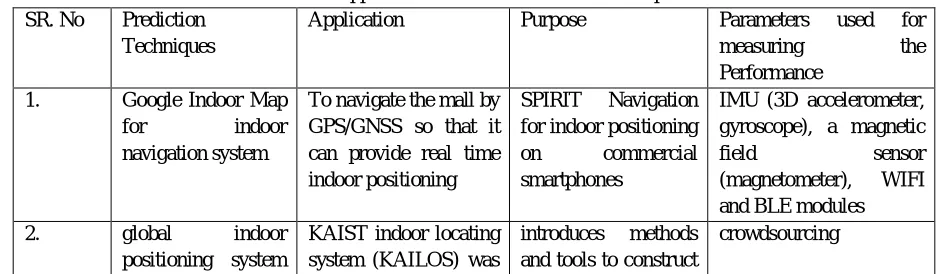
[image:3.612.69.539.592.729.2]The table below shows the discussed applications, algorithms & their purpose, parameters used for achieving prediction in each applicatio
Table 1: Applications & their Prediction Techniques
SR. No Prediction
Techniques
Application Purpose Parameters used for
measuring the
Performance
1. Google Indoor Map
for indoor
navigation system
To navigate the mall by GPS/GNSS so that it can provide real time indoor positioning
SPIRIT Navigation
for indoor positioning
on commercial
smartphones
IMU (3D accelerometer, gyroscope), a magnetic
field sensor
(magnetometer), WIFI
and BLE modules
2. global indoor
positioning system
KAIST indoor locating system (KAILOS) was
introduces methods
and tools to construct
(GIPS) using WLAN
fingerprinting
made to navigate large places using GIPS.
a GIPS by using WLAN fingerprinting
3. Android QR based
indoor parking
navigation services to locate parked vehicles in an indoor parking space
a smart wheeled
walker able to
estimate its own
position autonomously
Android app
4. the antenna
orientation effect on
indoor Wi-Fi
positioning
Using KNN algorithm and create fingerprint database
To navigate large
scale indoor
navigation
the fingerprint method and Kalman filter on Android mobile devices
5. MEMS based
indoor localization system
GNSS can’t position in shadow with the use of MEMS we can position in shadow region
To navigate in
shadow region using MEMS
Micro Electro
Mechanical
System,accelerometer,
gyroscope, magnetic
field sensor and
barometer
6. Geomagnetism and
crowdsensing
Powered Indoor
Navigation
GROPING can deliver a sufficient accuracy
for localization
provides smooth
navigation experience.
GROPING is more efficient then WIFI using GMI
Geomagnetic fingerprints
IV. EXISTING SYSTEM
Manual Shopping is the conventional method for shopping where the clients pick their wished item and convey the items alongside them. Conventional shopping is a repetitive and tedious occupation. In conventional shopping, the client needs to hold up in long lines at the money counter. This expends parcel of time and vitality of both the customer and additionally clerk.
Detriments of existing framework:
1) Existing framework is tedious.
2) In shopping centre its troublesome assignment to locate the required item
3) We can't look toss every one of the items on regular routine.
V. PROPOSED SYSTEM
The client himself examine the scanner tag utilizing his portable while influencing buy, to recover basic subtleties of all items from shops database and create charge himself. This bill can be sent to the client's versatile through web based saving money benefit in this way the client can make brisk installment and leave the shop early. The Barcode of the item is checked by the client and move to the list of things to get on the off chance that they are keen on decision of thing by utilizing the proposed portable application. Points of interest of propose framework:
1) Propose framework diminish the client shopping time
2) Provide the route to client for better experience of shopping
3) Barcode helps to distinguish item remarkably.
4) Users can investigate more items.
Fig: 5.1 Proposed System
VI. CONCLUSION
In a stage went for advancing shopping techniques and make individuals life less demanding; we will construct this portable application that could assume an imperative job in Indian culture in general. The use of Pocket PC shopping centre pilot as a shopping centre guide, notwithstanding helping the clients to discover shops productively and viably, had the ability to make mindfulness in utilizing keen cell phones for adaptability in pretty much every assignment among the shopping.
REFERENCES
[1] Ultekin, Oghuz Bay at Smart Location-Based Mobile Shopping Android Application Journal of Computer and Communications, 2014, 2, 54-63.
[2] Prof. Seema Vanjire, Unmesh Kanchan, Ganesh Shitole, Pradnyesh Patil, Location Based Services on Smart Phone through the Android Application, International Journal of Advanced Research in Computer and Communication Engineering Vol.3, Issue 1, January 2014.
[3] Mobile Technology, Applications and Systems, 2005 2nd International Conference on Bar code reading from images captured by camera phones
[4] P. E. Rybski, S. A. Stoeter, M. Gini, D. F. Hougen, and N. Papa Nikolopoulos.? Performance of a distributed system using shared communications channels.? IEEE Trans. on communication and Automation, 22(5):713727, Oct. 2002.
[5] M. Batalin and G. S. Sukhatme? Coverage, exploration and deployment by a I beacons and communication network? Telecommunication Systems Journal, Special Issue on Wireless Sensor Networks, 26(2):181196, 2004
[6] Imperial Journal of Interdisciplinary Research (IJIR)Vol.2, Issue-1, 2016 ISSN :2454-1362, www.onlinejournal.in [7] 2014, Dec). [Online]. Available: https://developer.apple.com/ibeacon/Getting- Started-with-iBeacon.pdf
[8] An indoor geolocation system for wireless LANs, in Parallel Processing Workshops, 2003. Proceedings. 2003 International Conference on, Oct 2003, pp. 2934. [9] Location _underprint analyses toward client indoor positioning, in Pervasive Computing and Communications, 2008. PerCom 2008. Sixth Annual IEEE
International Conference on, March 2008, pp. 100109.
[10] Object recognition using a tag. In 1997 International Conference on Image Processing (ICIP 97) 3-Volume Set-Volume 1, pages 877880. IEEE, IEEE Computer Society Press, 10 19