A Stacking-based Approach to Twitter User Geolocation Prediction
Bo Han,♠♥Paul Cook,♥ and Timothy Baldwin♠♥
♠NICTA Victoria Research Laboratory
♥Department of Computing and Information Systems, The University of Melbourne [email protected], [email protected],
Abstract
We implement a city-level geolocation prediction system for Twitter users. The system infers a user’s location based on both tweet text and user-declared metadata using a stacking approach. We demon-strate that the stacking method substan-tially outperforms benchmark methods, achieving 49% accuracy on a benchmark dataset. We further evaluate our method on a recent crawl of Twitter data to in-vestigate the impact of temporal factors on model generalisation. Our results sug-gest that user-declared location metadata is more sensitive to temporal change than the text of Twitter messages. We also de-scribe two ways of accessing/demoing our system.
1 Introduction
In this paper, we present and evaluate a geoloca-tion predicgeoloca-tion method for Twitter users.1 Given
a user’s tweet data as input, the task of user level geolocation prediction is to infer a primary loca-tion (i.e., “home localoca-tion”: Mahmud et al. (2012)) for the user from a discrete set of pre-defined loca-tions (Cheng et al., 2010). For instance, President Obama’s location might be predicted to be Wash-ington D.C., USA, based on his public tweets and profile metadata.
Geolocation information is essential to location-based applications, like targeted advertising and local event detection (Sakaki et al., 2010; MacEachren et al., 2011). However, the means to obtain such information are limited. Although Twitter allows users to specify a plain text scription of their location in their profile, these de-scriptions tend to be ad hoc and unreliable (Cheng
1We only use public Twitter data for experiments and
ex-emplification in this study.
et al., 2010). Recently, user geolocation predic-tion based on a user’s tweets has become popular (Wing and Baldridge, 2011; Roller et al., 2012), based on the assumption that tweets implicitly contain locating information, and with appropri-ate statistical modeling, the true location can be inferred. For instance, if a user frequently men-tionsNYC,JFK andyankees, it is likely that they are from New York City, USA.
In this paper, we discuss an implementation of a global city-level geolocation prediction system for English Twitter users. The system utilises both tweet text and public profile metadata for model-ing and inference. Specifically, we train multino-mial Bayes classifiers based on location indica-tive words (LIWs) in tweets (Han et al., 2012), and user-declared location and time zone meta-data. These base classifiers are further stacked (Wolpert, 1992) using logistic regression as the meta-classifier. The proposed stacking model is compared with benchmarks on a public geolo-cation dataset. Experimental results demonstrate that our stacking model outperforms benchmark methods by a large margin, achieving 49% accu-racy on the test data. We further evaluate the stack-ing model on a more recent crawl of public tweets. This experiment tests the effectiveness of a geolo-cation model trained on “old” data when applied to “new” data. The results reveal that user-declared locations are more variable over time than tweet text and time zone data.
2 Background and Related Work
Identifying the geolocation of objects has been widely studied in the research literature over target objects including webpages (Zong et al., 2005), search queries (Backstrom et al., 2008), Flickr im-ages (Crandall et al., 2009) and Wikipedia ed-itors (Lieberman and Lin, 2009). Recently, a considerable amount of work has been devoted to extending geolocation prediction for Twitter
users (Cheng et al., 2010; Eisenstein et al., 2010). The geolocations are usually represented by un-ambiguous city names or a partitioning of the earth’s surface (e.g., grid cells specified by lati-tude/longitude). User geolocation is generally re-lated to a “home” location where a user regularly resides, and user mobility is ignored. Twitter al-lows users to declare their home locations in plain text in their profile, however, this data has been found to be unstructured and ad hoc in preliminary research (Cheng et al., 2010; Hecht et al., 2011).
While popular for desktop machine geoloca-tion, methods that map IP addresses to physical locations (Buyukokkten et al., 1999) cannot be applied to Twitter-based user geolocation, as IPs are only known to the service provider and are non-trivial to retrieve in a mobile Internet environ-ment. Although social network information has been proven effective in inferring user locations (Backstrom et al., 2010; Sadilek et al., 2012; Rout et al., 2013), we focus exclusively on message and metadata information in this paper, as they are more readily accessible.
Text data tends to contain salient geospatial ex-pressions that are particular to specific regions. Attempts to leverage this data directly have been based on analysis of gazetted expressions (Leid-ner and Lieberman, 2011) or the identification of geographical entities (Quercini et al., 2010; Qin et al., 2003). However these methods are limited in their ability to capture informal geospatial expres-sions (e.g. Brissie for Brisbane) and more non-geospatial terms which are associated with partic-ular locations (e.g.ferryfor Seattle or Sydney).
Beyond identifying geographical references us-ing off-the-shelf tools, more sophisticated meth-ods have been introduced in the social media realm. Cheng et al. (2010) built a simple gen-erative model based on tweet words, and fur-ther added words which are local to particular re-gions and applied smoothing to under-represented locations. Kinsella et al. (2011) applied differ-ent similarity measures to the task, and investi-gated the relative difficulty of geolocation predic-tion at city, state, and country levels. Wing and Baldridge (2011) introduced a grid-based repre-sentation for geolocation modeling and inference based on fixed latitude and longitude values, and aggregated all tweets in a single cell. Their ap-proach was then based on lexical similarity us-ing KL-divergence. One drawback to the
uniform-sized cell representation is that it introduces class imbalance: urban areas tend to contain far more tweets than rural areas. Based on this observa-tion, Roller et al. (2012) introduced an adaptive grid representation in which cells contain approx-imately the same number of users, based on a KD-tree partition. Given that most tweets are from urban areas, Han et al. (2012) consider a city-based class division, and explore different feature selection methods to extract “location indicative words”, which they show to improve prediction accuracy. Additionally, time zone information has been incorporated in a coarse-to-fine hierarchical model by first determining the time zone, and then disambiguating locations within it (Mahmud et al., 2012). Topic models have also been applied to the task, in capturing regional linguistic differences (Eisenstein et al., 2010; Yin et al., 2011; Hong et al., 2012).
When designing a practical geolocation sys-tem, simple models such as naive Bayes and near-est prototype methods (e.g., based on KL diver-gence) have clear advantages in terms of train-ing and classification throughput, given the size of the class set (often numbering in the thousands of classes) and sheer volume of training data (poten-tially in the terabytes of data). This is particularly important for online systems and downstream ap-plications that require timely predictions. As such, we build off the text-based naive Bayes-based ge-olocation system of Han et al. (2012), which our experiments have shown to have a good balance of tractability and accuracy. By selecting a reduced set of “location indicative words”, prediction can be further accelerated.
3 Methodology
In this study, we adopt the same city-based rep-resentation and multinomial naive Bayes learner as Han et al. (2012). The city-based representa-tion consists of 3,709 cities throughout the world, and is obtained by aggregating smaller cities with the largest nearby city. Han et al. (2012) found that using feature selection to identify “location indicative words” led to improvements in geoloca-tion performance. We use the same feature selec-tion technique that they did. Specifically, feature selection is based on information gain ratio (IGR) (Quinlan, 1993) over the city-based label set for each word.
only the text of Twitter messages was used, and training was based exclusively on geotagged tweets, despite these accounting for only around 1% of the total public data on Twitter. In this research, we include additional non-geotagged tweets (e.g., posted from a non-GPS enabled de-vice) for those users who have geotagged tweets (allowing us to determine a home location for the user).
In addition to including non-geotagged data in modeling and inference, we further take advan-tage of the text-based metadata embedded in a user’s public profile (and included in the JSON ob-ject for each tweet). This metadata is potentially complementary to the tweet message and of bene-fit for geolocation prediction, especially the user-declared location and time zone, which we con-sider here. Note that these are in free text rather than a structured data format, and that while there are certainly instances of formal place name de-scriptions (e.g., Edinburgh, UK), they are often informal (e.g., melfor Melbourne). As such, we adopt a statistical approach to model each selected metadata field, by capturing the text in the form of character 4-grams, and training a multinomial naive Bayes classifier for each field.
To combine together the tweet text and meta-data fields, we use stacking (Wolpert, 1992). The training of stacking consists of two steps. First, a multinomial naive Bayes base classifier (L0) is learned for each data type using 10-fold cross validation. This is carried out for the tweet text (TEXT), user-declared location (MB-LOC) and user-declared time zone (MB-TZ). Next, a meta-classifier (L1 classifier) is trained over the base classifiers, using a logistic regression learner (Fan et al., 2008).
4 Evaluation and Discussion
In this section, we compare our proposed stack-ing approach with existstack-ing benchmarks on a public dataset, and investigate the impact of time using a recently collected dataset.
4.1 Evaluation Measures
In line with other work on user geolocation pre-diction, we use three evaluation measures:
• Acc : The percentage of correct city-level predictions.
• Acc@161: The percentage of predicted lo-cations which are within a 161km (100 mile)
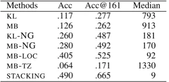
[image:3.595.333.502.62.144.2]Methods Acc Acc@161 Median KL .117 .277 793 MB .126 .262 913 KL-NG .260 .487 181 MB-NG .280 .492 170 MB-LOC .405 .525 92 MB-TZ .064 .171 1330 STACKING .490 .665 9
Table 1: Results overWORLD
radius of the home location (Cheng et al., 2010), to capture near-misses (e.g., Edin-burgh UK being predicted as Glasgow, UK).
• Median: The median distance from the pre-dicted city to the home location (Eisenstein et al., 2010).
4.2 Comparison with Benchmarks
We base our evaluation on the publicly-available WORLDdataset of Han et al. (2012). The dataset contains 1.4M users whose tweets are primarily identified as English based on the output of the langid.pylanguage identification tool (Lui and Baldwin, 2012), and who have posted at least 10 geotagged tweets. The city-level home location for a geotagged user is determined as follows. First, each of a user’s geotagged tweets is mapped to its nearest city (based on the same set of 3,709 cities used for the city-based location representa-tion). Then, the most frequent city for a user is selected as the home location.
The approximate doubling of Acc for KL -NG and MB-NG over KL and MB, respectively, demonstrates the high utility of non-geotagged data in tweet text-based geolocation prediction. Of the two original models, we can see that MB is comparable to KL, in line with the findings of Han et al. (2012). TheMB-LOCresults are by far the highest of all the base classifiers. Contrary to the suggestion of Cheng et al. (2010) that user-declared locations are too unreliable to use for user geolocation, we find evidence indicating that they are indeed a valuable source of information for this task. The best overall results are achieved for the stacking approach (STACKING), assigning almost half of the test users to the correct city-level lo-cation, and improving more than four-fold on the previous-best accuracy (i.e., MB). These results also suggest that there is strong complementarity between user metadata and tweet text.
4.3 Evaluation on Time-Heterogeneous Data In addition to the original held-out test data (WORLDtest) from WORLD, we also developed a new geotagged evaluation dataset using the Twit-ter Streaming API.2 This newLIVE
testdataset is intended to evaluate the impact of time on predic-tive accuracy. The training and test data inWORLD are time-homogeneous as they are randomly sam-pled from data collected in a relatively narrow time window. In contrast,LIVEtestis much newer, col-lected more than 1 year later thanWORLD. Given that Twitter users and topics change over time, an essential question is whether the statistical model learned from the “old” training data is still effec-tive over the “new” test data?
TheLIVEtestdata was collected over 48 hours from 2013/03/03 to 2013/03/05. By selecting users with at least 10 geotagged tweets and a de-clared language of English, 55k users were ob-tained. For each user, their recent status updates were aggregated, and non-English users were fil-tered out based on the language predictions of langid.py. For some users with geotagged tweets from many cities, the most frequent city might not be an appropriate representation of their home location for evaluation. To improve the eval-uation data quality, we therefore exclude users who have less than 50% of their geotagged tweets originating from a single city. After filtering, 32k
2https://dev.twitter.com/docs/api/1.1/
get/statuses/sample
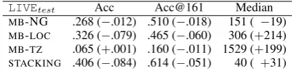
LIVEtest Acc Acc@161 Median
[image:4.595.309.522.62.113.2]MB-NG .268 (−.012) .510 (−.018) 151 ( −19) MB-LOC .326 (−.079) .465 (−.060) 306 (+214) MB-TZ .065 (+.001) .160 (−.011) 1529 (+199) STACKING .406 (−.084) .614 (−.051) 40 ( +31)
Table 2: Results overLIVEtest, and the absolute fluctuation over the results forWORLDtest
users were obtained, forming the final LIVEtest dataset. In the finalLIVEtest, the smallest class has only one test user, and the largest class has 569 users. The mean users per city is 27.76.
The results over LIVEtest, and the difference in absolute score over WORLDtest, are shown in Table 2. The stacked model accuracy numbers drop 5–8% on LIVEtest, and the median error distance increases moderately by 31km. Over-all, the numbers suggest inference onWORLDtest, which is time-homogenous with the training data (taken from WORLD), is an easier classification thanLIVEtest, which is time-heterogeneous with the training data. Training on “old” data and test-ing on “new” data is certainly possible, however. Looking over the results of the base classifiers, we can see that the biggest hit is for MB-LOC clas-sifier. In contrast, the accuracy for MB-NG and MB-TZis relatively stable (other than the sharp in-crease in the median error distance forMB-TZ).
5 Architecture and Access
In this section, we describe the architecture of the proposed geolocation system, as well as two ways of accessing the live system.3 The core structure
of the system consists of two parts: (1) the inter-face; (2) the back-end geolocation service.
We offer two interfaces to access the system: a Twitter bot and a web interface. The Twitter bot account is: @MELBLTFSD. A daemon process de-tects any user mentions of the bot in tweets via keyword matching through the Twitter search API. The screen name of the tweet author is extracted and sent to the back-end geolocation service, and the predicted user geolocation is sent to the Twitter user in a direct message, as shown in Figure 1.
Web access is viahttp://hum.csse.unimelb.
edu.au:9000/geo.html. Users can input a
Twit-ter user screen name through the web inTwit-terface, whereby a call is made to the back-end tion service to geolocate that user. The
geoloca-3The source code is available fromhttps://github.
Figure 2: Web interface for user geolocation. The numbered green markers represent geotagged tweets. These coordinates are utilised to validate our predictions, and are not used in the geolocation process. The red marker is the predicted city-based user geolocation.
Figure 1: Twitter bot interface. When the Twit-ter bot is mentioned in a tweet, that user is sent a direct message with the predicted geolocation.
tion results are rendered on a map (along with any geotagged tweets for the user) as in Figure 2.4
The back-end geolocation service crawls recent tweets for a given user in real time,5 and word
and n-gram features are extracted from both the text and the user metadata. These features are sent to theL0classifiers (TEXT,MB-LOCandMB-TZ), and theL0results are further fed into theL1 clas-sifier for the final prediction.
6 Summary and Future Work
In this paper, we presented a city-level geoloca-tion predicgeoloca-tion system for Twitter users. Over a public dataset, our stacking method — exploiting both tweet text and user metadata — substantially
4Currently, only Google Chrome is supported. https:
//www.google.com/intl/en/chrome/
5Up to 200 tweets are crawled, the upper bound of
mes-sages returned per single request based on Twitter API v1.1.
outperformed benchmark methods. We further evaluated model generalisation on a newer, time-heterogeneous dataset. The overall results de-creased by 5–8% in accuracy, compared with num-bers on time-homogeneous data, primarily due to the poor generalisation of theMB-LOCclassifier.
In future work, we plan to further investigate the cause of the MB-LOC classifier accuracy de-crease on the new dataset. In addition, we’d like to study differences in prediction accuracy across cities. For cities with reliable predictions, the sys-tem can be adapted as a preprocessing module for downstream applications, e.g., local event detec-tion based on users with reliable predicdetec-tions.
Acknowledgements
NICTA is funded by the Australian government as represented by Department of Broadband, Com-munication and Digital Economy, and the Aus-tralian Research Council through the ICT centre of Excellence programme.
References
Lars Backstrom, Jon Kleinberg, Ravi Kumar, and Jas-mine Novak. 2008. Spatial variation in search en-gine queries. In Proc. of WWW, pages 357–366, Beijing, China.
[image:5.595.81.286.352.429.2]Orkut Buyukokkten, Junghoo Cho, Hector Garcia-Molina, Luis Gravano, and Narayana Shivakumar. 1999. Exploiting geographical location informa-tion of web pages. InACM SIGMOD Workshop on The Web and Databases, pages 91–96, Philadelphia, USA.
Zhiyuan Cheng, James Caverlee, and Kyumin Lee. 2010. You are where you tweet: a content-based approach to geo-locating twitter users. In Proc. of CIKM, pages 759–768, Toronto, Canada.
David J. Crandall, Lars Backstrom, Daniel Hutten-locher, and Jon Kleinberg. 2009. Mapping the world’s photos. InProc. of WWW, pages 761–770, Madrid, Spain.
Jacob Eisenstein, Brendan O’Connor, Noah A. Smith, and Eric P. Xing. 2010. A latent variable model for geographic lexical variation. In Proc. of EMNLP, pages 1277–1287, Cambridge, MA, USA.
Rong-En Fan, Kai-Wei Chang, Cho-Jui Hsieh, Xiang-Rui Wang, and Chih-Jen Lin. 2008. LIBLINEAR: A library for large linear classification. Journal of Machine Learning Research, 9:1871–1874.
Bo Han, Paul Cook, and Timothy Baldwin. 2012. Ge-olocation prediction in social media data by find-ing location indicative words. InProc. of COLING, pages 1045–1062, Mumbai, India.
Brent Hecht, Lichan Hong, Bongwon Suh, and Ed H. Chi. 2011. Tweets from justin bieber’s heart: the dynamics of the location field in user profiles. In Proc. of SIGCHI, pages 237–246, Vancouver, Canada.
Liangjie Hong, Amr Ahmed, Siva Gurumurthy, Alexander J. Smola, and Kostas Tsioutsiouliklis. 2012. Discovering geographical topics in the twit-ter stream. InProc. of WWW, pages 769–778, Lyon, France.
Sheila Kinsella, Vanessa Murdock, and Neil O’Hare. 2011. ”I’m eating a sandwich in glasgow”: mod-eling locations with tweets. InProc. of the 3rd In-ternational Workshop on Search and Mining User-generated Contents, pages 61–68, Glasgow, UK. Jochen L. Leidner and Michael D. Lieberman. 2011.
Detecting geographical references in the form of place names and associated spatial natural language. SIGSPATIAL Special, 3(2):5–11.
Michael D. Lieberman and Jimmy Lin. 2009. You are where you edit: Locating wikipedia contributors through edit histories. InICWSM.
Marco Lui and Timothy Baldwin. 2012. langid.py: An off-the-shelf language identification tool. InProc. of the ACL, pages 25–30, Jeju Island, Korea. Alan M. MacEachren, Anuj Jaiswal, Anthony C.
Robinson, Scott Pezanowski, Alexander Savelyev, Prasenjit Mitra, Xiao Zhang, and Justine Blanford. 2011. Senseplace2: Geotwitter analytics support for situational awareness. In IEEE Conference on Vi-sual Analytics Science and Technology, pages 181– 190, Rhode Island, USA.
Jalal Mahmud, Jeffrey Nichols, and Clemens Drews. 2012. Where is this tweet from? inferring home lo-cations of twitter users. InProc. of ICWSM, Dublin, Ireland.
Teng Qin, Rong Xiao, Lei Fang, Xing Xie, and Lei Zhang. 2003. An efficient location extraction algo-rithm by leveraging web contextual information. In Proc. of SIGSPATIAL, pages 55–62, San Jose, USA. Gianluca Quercini, Hanan Samet, Jagan Sankara-narayanan, and Michael D. Lieberman. 2010. De-termining the spatial reader scopes of news sources using local lexicons. InProc. of the 18th Interna-tional Conference on Advances in Geographic In-formation Systems, pages 43–52, San Jose, USA. John Ross Quinlan. 1993. C4.5: Programs for
Ma-chine Learning. Morgan Kaufmann, San Mateo, USA.
Stephen Roller, Michael Speriosu, Sarat Rallapalli, Benjamin Wing, and Jason Baldridge. 2012. Super-vised text-based geolocation using language mod-els on an adaptive grid. InProc. of EMNLP, pages 1500–1510, Jeju Island, Korea.
Dominic Rout, Kalina Bontcheva, Daniel Preot¸iuc-Pietro, and Trevor Cohn. 2013. Where’s @wally?: a classification approach to geolocating users based on their social ties. InProc. of the 24th ACM Con-ference on Hypertext and Social Media, pages 11– 20, Paris, France.
Adam Sadilek, Henry Kautz, and Jeffrey P. Bigham. 2012. Finding your friends and following them to where you are. InProc. of WSDM, pages 723–732, Seattle, USA.
Takeshi Sakaki, Makoto Okazaki, and Yutaka Matsuo. 2010. Earthquake shakes twitter users: real-time event detection by social sensors. InProc. of WWW, pages 851–860, Raleigh, USA.
Benjamin P. Wing and Jason Baldridge. 2011. Sim-ple supervised document geolocation with geodesic grids. In Proc. of ACL, pages 955–964, Portland, USA.
David H. Wolpert. 1992. Stacked generalization. Neu-ral Networks, 5(2):241–259.
Zhijun Yin, Liangliang Cao, Jiawei Han, Chengxiang Zhai, and Thomas Huang. 2011. Geographical topic discovery and comparison. InProc. of WWW, pages 247–256, Hyderabad, India.