THE AGRO PONTINO SURVEY PROJECT
Methods and preliminary results
Editors:
A. Voorrips, S.H. Loving, H. Kamennans.
Offprint
31
THE SOILS OF THE AGRO PONTINO
J. Sevink, J. Duivenvoorden, and H. Kamermans
SUMMARY
This article describes results of a soil survey of the Agro Pontino. The soils in the region reflect the influence of parent material, drainage, slope class, and time, which are incorporated in the classification of the soils. The soil map provided a framework for the archaeological survey.
1 INTRODUCTION
1.1 General background
Between 1967 and 1985, the soils of the Agro Pontino were studied by staff and students from the Laboratory of Physical Geography and Soil Science of the University of Amsterdam. Results from this research have been published by Sevink (1977), Remmel-zwaal (1978), and Sevink et al. (1982 and 1984). These publications concerned the soils in the central and southern parts of the Agro Pontino. Other results, including those pertain-ing 10 the northwestern part of the Agro Pomino, were presented in inaccessible internal reports of the forementioned Laboratory (Dessing 1972; Kamermans et al. 1979; Kamer-mans 1980; Bouman and Rot 1982; Van Huissteden 1983; Duivenvoorden 1983a, 1983b, 1985; Snoek and Giessen 1985). This paper, which provides a broad outline of the soils in the Agro Pontino, brings together all the information gathered by these research efforts.
1.2 Climate
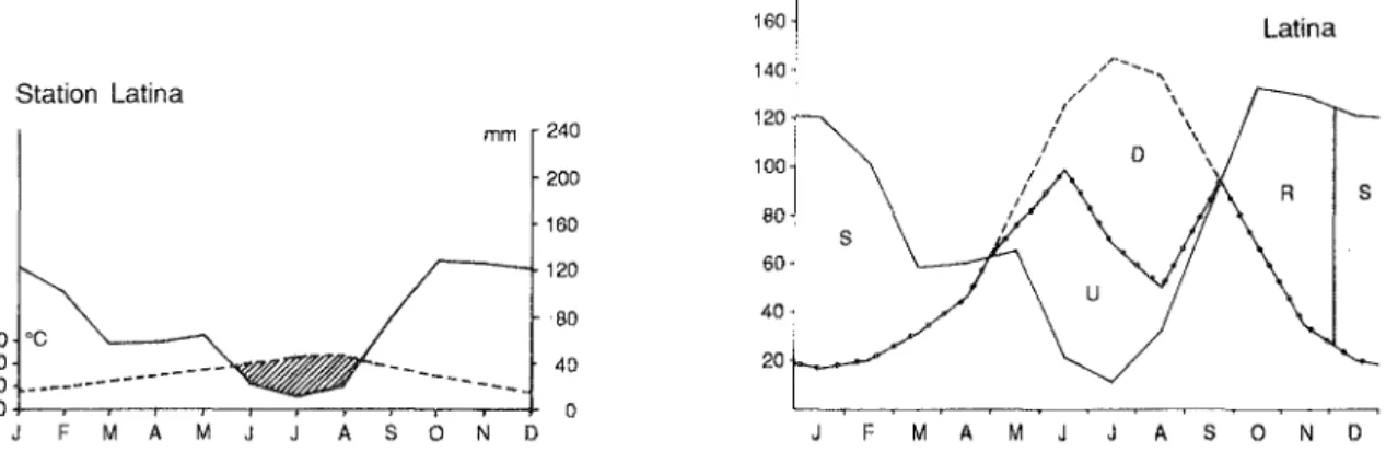
The climate of the Agro Pontino can be classified as a Csa climate according to Koppen (Koppen and Geiger 1954), which implies that it is mild and moist in autumn and winter and hot and dry in summer. According to the Bioclimatic Map of the World (UNESCO/FAO 1963), the area has a warm temperate, meso-mediterranean climate. This means that the mean monthly temperature is always above 0° C and that during the summer period 40-75 days are dry. Data from Latina airport on temperature and precipita-tion are presented in the ombrothermic diagram (Figure 1). The mean annual temperature is 15° C, the mean annual precipitation is between 800 and 900 mm, and the soil moisture regime, according to the Soil Taxonomy (Soil Survey Staff, 1975), is xeric.
160 Latina
140
Station Latina
mm 240 120
s
200 100
80
s
160
120 60
80 40
30 "C
20 40 20
10 .... ---
---a 0
J F M A M J J A S 0 N D F M A M J A S O N D
32 1. Sevink, J. Duivenvoorden, and H. Kamermans
1.3 Man, land use and vegetation
In view of the foregoing description of the history of the area (see Koot, this volume), it is not surprising that the vegetation on the whole is strongly influenced by man and closely related to land use. The only exception is the Parco Nazionale, with its semi-natural forests. In the Agro Pontino, agriculture is very intensive and flourishing. It is marked by a high degree of mechanization and frequent use of sprinkler irrigation. Wheat, maize, forage crops, sugarbeets, and many other crops are produced. An exception is a large area around Latina where soils are very unsuitable for agriculture. Here some attempts have been made to introduce modem viticulture, but abandoned fields and rough grazing land are rather common. Also rather unsuitable are the very poorly drained soils in the coastal area, which are used for pasture or planted with poplars.
The expanding industry around Latina has withdrawn large areas from agricultural use. Similar effects are produced by the tourist industry; today, holiday resorts cover the major part of the coastal area, including the entire dune area between S.Felice Circeo and Terracina.
1.4 Soil classification and soil survey
The soils of the Agro Pontino were surveyed using a physiographic approach, which pays particular attention to the relationships between the physiography and the soils, and employing rather standardized survey methods. These methods can be briefly described as follows: firstly, sample areas were selected that represented the various landscapes in the area. These sample areas were studied in the field for their soils and superficial geology, paying particular attention to the relation between the soil and the landscape. The results were used for an aerial photographic interpretation of the remaining area, which sub-sequently was checked in the field. Since it appeared that aerial photographic interpretation often provided too little infonnation about the Agro Pontino, many extra observations had to be made (several thousands of borings and hundreds of observations in pits and exposures).
The soils were described according to the Guidelines for Soil Profile Description of the FAO (1967). This system is based on the recognition of genetic soil horizons, the so-called A-B-C concept. Soil colours were estimated in the field using the Munsell Soil Color Charts (Munsell 1954).
The soils were classified according to the Legend for the Soil Map of the World (FAO/UNESCO 1974). This system makes use of diagnostic horizons and properties, which were developed for the earlier approximations of the Soil Taxonomy and later on adapted in a slightly altered fonn by the FAO/UNESCO system.
2 THE MAJOR SOIL FORMING PROCESSES AND CHRONOSEQUENCES
Soil fonnation is controlled by a number of factors, including parent material, drainage, and time. These factors, rather than their classil1cation are often used as keys for the systematic description of the soils in a specific area. The keys chosen for the Agro Pontino soils are the nature and age of the parent material, since these have the strongest control over the characteristics of the soils.
Prior to the description of the soils in the various units, some general trends in soil formation will be described. For a more extensive description reference is made to the publications of Remmelzwaal (1978), Sevink et al. (1984), and Cremaschi and Sevink (1987).
The soils of the Agro Pontino 33
formation of clay by a combination of inheritance (mainly of illitcs) and of neoformation (mainly of smectites), to clay translocation and to rubefaction. More explicitly, through time soils gradually develop a clayey argillic B horizon with a reddish colour. With increasing clay translocation and clay formation, the permeability of the argillic B horizon decreases and the soil acquires features characteristic for pseudogley, such as strong Fe-and Mn-mottling in the B horizon Fe-and a bleached Fe-and impoverished albic Eg horizon. Concurrently, the argillic B horizon acquires more or less pronounced vertic properties and may show some accumulation of carbonates in the lower part of the soil.
In highly permeable parent materials, such as gravels, sands and tuffs, leaching and weathering are more intense, and kandite is formed rather than smectite. Clay translocation and rubefaction are quite prominent and eventually produce a very thick (up to 4 m) reddish argillic B horizon. Largely because of the non-swelling nature of the clay minerals formed, the decrease in permeability with increasing age is far less pronounced and only in a very latc stage do pseudogley phenomena appear.
Soil formation in clayey parent materials is strongly determined by the mineralogy and permeability of these materials. Most marine, lagoonal, or lacustrine deposits are high in swelling clay minerals (in particular smectite) and, in the alternating dry-wet mediterranean climate, rapidly develop into Vertisols, which change very little in time. Because of their low permeability during the wet season leaching is weak and carbonates, or even gypsum, accumulate in the lower part of the soil.
Clayey parent materials of fluvial (alluvial fans) or colluvial origin and derived from volcanic soils or residual limestone soils (terra rossa) commonly have a reddish to reddish-brown inherited colour and are higher in kandite. The non-swelling nature of the clay results in a somewhat higher permeability and, concurrently, distinct clay translocation and leaching, the latter being cvidenced by the general absence of secondary carbonates. The soils, howevcr, tend to develop a distinctly vcrtic B horizon.
The above described tendencies for soils in medium to coarse textured parent materials relate to the soils with more or less uniform textures. It is only during the later stages of soil formation that these soils acquire a slowly permeable B-horizon and features related to alternating oxidation and reduction. In contrast, soils in parent materials consisting of sand or loam over clay, rapidly become slowly permeable. Such parent materials are rather frequently encountered in the lagoonal areas and probably were formed through aeolian deposition of sand on top of lagoonal clay. These soils rapidly develop a bleached and mottled albic Eg horizon and an argillic B horizon with prominent pseudogleyic features, with no intermediate stage in which a rubefied argillic B horizon is formed. The argillic B horizon generally shows strongly developed vcrtic properties, including intersecting slickensides, and, in its lower part, often contains secondary carbonates. If these soils show an abrupt textural change, they are classified as Planosols, whereas, if they exhibit a more gradual change in texture, they are classified as Albic Gleyic Luvisols. Once formed, these soils change very little in time because of their poor internal drainage.
3 THE SOILS IN MARINE-AEOLIAN DEPOSITS
As discussed .elsewhere (see Karnermans, this volume) the marine-aeolian deposits can be subdivided into a series of marine terraces of widely differing ages. These differences in age are reflected in the soils and, in fact, most of the trends described above are based on comparative studics of soils on dated marine terraces. Equally important, however, are the differences in parent materials within these terraces, which gives rise to major differences in soil development.
34
~
J. Sevink, J. Duivenvoorden, and H. Kamermans
.3'
.'i
rn
~
.'l
m ~
.3'
~---o
~
~---
~---.---~
f======_= _________________ _
_m
-,
16
bi
~ ~
z
~-
£
11
~I
E J!
~
I
D
~ "!
~
~
1
g g~
"
.
~ "i
~
~ er ~
~
~
~
§J
'" Cl ~"
j
E$
"8
~
~
i>
"
~ " []
t3
>-'='
:Cif> ] g
~~
1
~~
o~ .w
g g ]
l
~ ~
~
~
0 1:
3 it of! ~
The soils of the i\gro Ponlino 35
3.1 The soils of the Terracina level
The soils in the dune sands (soil map unit a 1; Figure 2) are very weakly developed. They have ochric epipedons which range from very weak to very well developed with a corresponding development of colour, structure, thickness, and organic C content. B horizons are virtually absent. The dominant soil type is a Calcaric Regosol. Near the transition towards the lagoonal area, where drainage is poor, the soils can be classified as Calcaric Fluvisols.
Soil formation in the (sub)recent Jagoonal sediments has also been weak (Figure 2). Most soils have an ochric epipedon which, except for its structure (hard and massive). meets all the requirements for a mollic epipedon. This epipedon is overlying a C horizon which is reduccd or, in the upper part, exhibits glcy mottling and has a weak soil structure at most, mainly resulting from alternate wetting and drying. These soils are classified as Fluvisols (soil map units b3 and b4). Where soils are better drained (for the most part artificially), B horizons are found with a slightly better developed structure and more pronounced mottling. These horizons meet the requirements for a wet cambic B, and such soils can be classified as Gleysols (soil map units b6 and b7).
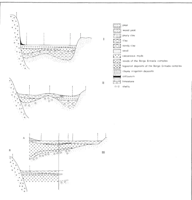
The foregoing description relates to the soils in lagoonal deposits, which are relatively low in organic matter or carbonates. In the graben, however, peats and calcareous deposits (travertincs and calcareous muds) are rather widespread. The soils developed in peat (soil map units bI, b2 and b5) tend to have a very dark topsoil with a strong crumb to subangular blocky structure. The organic material is strongly decomposed and plant remnants are virtually absent. These soils can be classified as Eutric Histosols and Mollic Gleysols (if the histic H horizon is thinner than 40 cm). On the calcareous muds and travertines, which frequently occur in association with peats, very dark fine textured and highly calcareous mollic epipedons are found, and these soils are classified as Rendzinas (soil map units b2, b8 and b9; Figure 3 and 4).
Over relatively large areas in the graben the Holocene lagoonal deposits are thin, and the underlying lagoonal clays of the Borgo Ermada level are within a depth of less than 1 metre from the surface. Soils in such deposits have been classified as Chromic Vertisols (soil map unit blO), mainly because of the presence of well developed intersecting slickensides in the top of the older Jagoonal clays. The Holocene layer can be identified by its relatively high organic matter content and very limited soil formation.
Finally, it should be stressed that soils in the lagoonal area, in between Sabaudia and the Astura, are partly anthropogenic in origin, i.e. the lower, poorly drained areas have often been raised by man. A large variety of materials have been used, including slushes from the adjacent lagoons and drainage canals, excavated materials from construction sites, and topsoils from adjacent older beach ridges.
3.2 The soils in the Early Holocene to Wurmian sands
In the southern part of the Agro Pontino extensive sheets of aeolian sands occur, partly or completely covering older marine-Iagoonal deposits. According to Sevink et al. (1984), they date from the Wiirm to Early Holocene. Although covering smaller areas, these sands also occur in the area near Foce Verde, where they rest on top of the deposits of the Borgo Ermada level.
The epipedons of the soils in these aeolian deposits tend to be thicker and darker than those in the (sub)recent dune sands. Several phases have been distinguished on the basis of the soil formation in these deposits and the presence of intercalated paleosols.
36
, 0 ' 0 '0
o 0
, ' 0
o 0 r"""-~~--'---'-~
a.
B ! 0, '
, 0 ,
o
o 0
o
ooo,~~~
1. Sevink, 1. Duivenvoorden, and H. Kamermans
~ peat
~ wood peat
C; y;;J peaty clay
[-=-J clay [-7=~J sandy clay
1:·.·· .. ·.:..:1 sand
~ calcareous muds
I:.~~,; ,0
01 sands of the Borgo Ermada complex
I:o~ 0;1 lagaonal depOSits of the Borgo Ermada complex
ITIIIJ
clayey Irrigation deposits~ calluvlum
11 @ limestone
C:J CS shells
III
Figure 3. Cross-sections I, II and III of the recent coastal plain west of Terracina. (Sevink et al.
1984). Locations of the cross-sections are shown on Figure 4.
as Eutric Regosols (soil map unit cl) or, if they have a Bw horizon, as Cambic Arenosols (soil map unit c3). In the southern part of the Agro Pontino relief in these sands may be considerable and in "interdunal depressions" Haplic Phaeozems (soil map unit cS) prevail. These soils are probably partly of colluvial origin.
In the older sands, which are largely restricted to the southern part of the Agro Pontino and in that area only locally crop out, clay illuviation is more pronounced and a distinct argillic horizon can be found. It has a sandy loamy texture and cutans in pores and on faces of the coarse prismatic to subangular blocky peds. Colours are usually 1O-7.S YR 6/6, and some coarse Mn-mottling is commonly observed. The soil type is an Orthic Luvisol or, locally, Chromic Luvisol.
The soils of the Agro Pontino 37
I
o
I
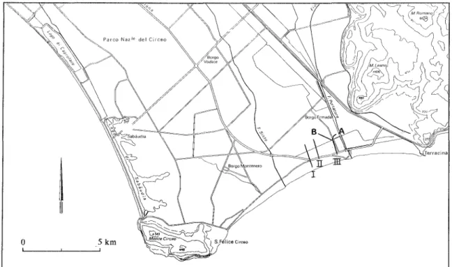
Figure 4. Location of cross-sections T, II and llT in the Agro Pontino. (after Sevink et al. 1984)
In these instances the soil development in the sandy top layer is weak (Cambic Arenosols to Luvic Arenosol) and this layer rests on a buried, stronger developed older soil (Chromic, Orthic or Gleyic Luvisol) in deposits that form part of the Borgo Ermada level. Generally, the sandy top layer is rather thin (less than 1 m), consists of albic material, and rests on a finer textured B horizon. Strati graphic hiata generally cannot be identified in these soils.
3.3 The soils of the Borgo Ermada level
The soils in the sands of the beach ridge deposits (Figure 2) have an ochric epipedon overlying a well developed argillic horizon with a colour of 7.5 YR 5/6-8. Cutans are clearly recognizable. If not eroded, these soils have an E horizon, which often meets the requirements for an albic horizon, but most soils are more or less eroded. The argillic B horizon shows clear Fe/Mn-mottling in its lower part, and the solum generally is about 2 m thick. The soils can be classified as Albic (rare) or Chromic Luvisols (soil map unit dl). Where soils have been rather strongly eroded (in particular near Foce Verde) the soils are classified as Orthic Luvisols (soil map unit d2). Furthermore, some of the soils are gravelly (soil map unit d3).
The lagoonal deposits (Figure 2) close to the former beach ridges contain sand, admixed throughout the profile or, more commonly, concentrated in a sandy top layer. Soils in these deposits have a slowly permeable clayey B horizon, covered by a sandy to loamy E horizon. The B horizon is 10 YR or yellower coloured and has pronounced hydromorphic properties (pseudogley). If there is an abrupt textural change, in which case the E horizon is strongly bleached and contains Fe-Mn nodules, the soil can be classified as a So Iodic Planosol (soil map unit e4). Soils with a more gradual textural change show less pronounced bleaching and hydromorphic properties and can be classified as Gleyic Luvisols or, locally, as Gleyic Cambisols (soil map units e2, e3 and e5).
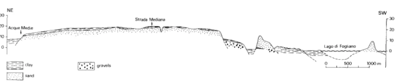
38 J. Sevink. 1. Duivenvoorden. and H. Kamermans
NE sw
30
Strada Medlana 30
I
20 ACqUet'~'d,:e=~~~;::=. C='~~:'--:-:c"""""::""':::;'T'.::.",: .. ~. ~0ry~~~~~ 20
10
---." - 10
- /
Lago dl Fogllano
I==~clay IT~ gravels C J s a n d
Figure 5. Cross-section of the Latina-Sabaudia area. (Sevink et al. 1984)
is generally a distinct nodular calcic horizon, transitional to a petrocalcic horizon, and lies at a depth of about 100 cm in non-eroded soils. The colour of the topsoil is lOYR 4/2-3. In most places the epipedon has a granular structure, while below angular blocky peds dominate. Near Borgo Podgora the lagoonal clays, with a partially preserved paleosol, unconformably rest on tuffs. In places these tuffs are within a depth of one metre, but have little effect on the soils, which invariably are Chromic Vertisols.
In the northern part of the Agro Pontino circumlagoonal deposits of the Borgo Ermada level are found (soil map unit e6). These level deposits consists of heavy textured clays, which, in places are high in volcanic material and are imperfectly drained. They have a distinct calcic horizon, which locally grades into a very thick pctrocalcic horizon. The soils have dark colours, but most arc Chromic Vertisols; Pellic Vertisols are less common.
3.4 The soils of the Minturno level
The soils in the beach ridge deposits (Figure 2) are usually more or less eroded (soil map unit 1'1). Characteristic for the less eroded soils is a thick well developed argillic horizon. Clay cutans arc prominent, and Fe/Mn nodules and mottling arc common in the lower part of the argillic horizon. They can be classifIed as Eutric Nitosols or, more rarely, as Ferric Luvisols. Where eroded, the soils can be classified as Chromic Luvisols or, if erosion has been more severe, as Orthic Luvisols or Eutric Cambisols. Their A horizons are thin and often formed in the top of the argillic B horizon.
The lagoonal deposits cover gravelly littoral deposits (Figure 2 and 5) and are more or less eroded. Non-eroded soils, which are scarce, have a thin, sandy ochric A horizon and a well devcloped but thin, sandy albic Eg horizon with some Fe/Mn nodules abruptly overlying a fine textured B horizon. The B horizon lacks clear clay illuviation phenomena and as a consequence is a cambic B horizon. The soils can be classified as Solodic Planosols. The sandy topsoil, however, is often absent or has been eroded, and the underlying B horizon is exposed (soil map unit gl), in which case those with a clayey vertic topsoil are to be classified as Chromic Vertisols and those with a less clayey topsoil, which are more common, as G1cyic Luvisols. Where erosion has been so strong that the underlying gravels are exposed (soil map unit g2), the soils have a thin ochric epipedon overlying an argillic B horizon with pronounced pseudogley and a very gravelly clay to clay loam texture. The clay translocation is not very pronounced and vertic properties and slickensides are lacking. These soils are classified as Gleyic Luvisols.
The dominant soils in heavy clay circumlagoonal deposits in the northern part of the Agro Pontino are Vertisols (soil map unit g3). They are characterized by pronounced pseudogley features. Compared with the Vertisols of the circumlagoonal deposits of the Borgo Ermada leVel, chromas and values are higher and colours of 10 YR 5-4/4-6 are common. The content of Fe/Mn concretions is rather high and they have a calcic horizon.
40 1. Se vink , 1. Duivenvoorden, and H. Kamermans
developed, probably being fonned in relatively recent aeolian sands of local ongm (soil map unit c2), which cover older strata. These soils are classified as Cambic Arenosols and Eutric Regosols.
4 THE SOILS IN ALLUVIAL DEPOSITS AND SLOPE DEPOSITS
In the Agro Pontino there is a wide range of fluvial deposits. Well sorted fluvial deposits are rare, being restricted to a few larger alluvial fans and an isolated small terrace. The further subdivision of the soils is primarily based on the sediment characteris-tics and their mode of deposition.
Fluvio-colluvial deposits are encountered in the larger river valleys that cut through the marine terraces and in the graben, where they cover large areas. All of these exhibit poor sorting and weakly expressed stratification. The bulk of the sediment, in fact, consists of aggregated soil material, which has been transported over relatively short distances and has been only slightly altered during this transport. The deposits generally have a colour that is clearly inherited from the soils and materials, from which the sediment has been derived, and have a relatively high organic matter content.
The valley fills largely consist of colluvial material derived from adjacent slopes and, consequently, lhelr composition sometimes varies over short distances. The basin fills, on the contrary, are very unifonn in texture and mineralogy.
The lower slopes of the Monte Circeo and of the Volsci Range are covered with slope deposits and alIuvial fan deposits, of which the latter locally extend far into the plain. They widely vary in age and, consequently show large differences in soil fonnation. Unlike the fans of the larger rivers, which are unifonnly composed of fan deposits, alluvial fan deposits and slope deposits often alternate and laterally grade into each other. Their composition depends on the geology of the hinterland and is high in volcanics in the western part of the Agm Pontino, and in limestone and residual limestone soils (terra rossa) in the eastern part.
4.1 The soils in fluvio-colluvial valley lllls
These soils are largely restricted to the western part of the Agro Pontino, Le. to the valleys of the Astura and Fosso di Moscarello and their tributaries (soil map unit 11). In the large valleys soils often show some stratification. They have a texture of clay to clay loam and most can be classified as Eutric and Calcaric Fluvisols. The soils in the smaller valleys have more variable textures (clay to sandy loam) and are more complex; in some places, soils have a weak camblc B. Moreover, towards the valley slopes the thickIless of the colluvial cover decreases and soils in beach ridge or lagoonal deposits may occur at a depth of less than 50 cm. Soils in these smaller vaUeys can be classified as F1uvisols or Gleysols (rare) or, if they have a thin colluvial cover, as Luvisols, which are generally Chromic (for example south of Latina). Chromic Luvisols are also encountered in the valleys filled with material derived from volcanic rocks (tuffs) in the northwest of the Agro Pontino (soil map unit 12).
4.2 The soils in lZuvio-colluvial basin fills
The soils of the Agro Pontino 39
than that of the Mintumo beach ridge. The development of the argillic B horizon in these soils is equivalent to that of soils in the Minturno beach ridge. For that reason, it is assumed that the aeolian sands are probably related to the Minturno transgressive phase. Evidently, the underlying sands, with well developed paleosols, represent older aeolian or beach ridge deposits, but these are only exposed in places, mainly in steep fluvial incisions. Unit f2 (soil map) is identical to unit f3, except for locally occurring younger (presumably Wiirmian) sands with Cambic Arenosols.
3.5 The soils of the Latina level
As described elsewhere (see Kamermans, this volume), the Latina level consists of a partly preserved beach ridge and a lagoonal plain. It is rather strongly dissected and eroded, particular along its seaward border and in the northwest, resulting in a complex soil pattern.
In the least eroded parts of the beach ridge in the northwest (soil map unit hI), soils have a very thick, reddish argillic horizon and can be classified as Eutric Nitosols (De Wit
et al. 1987). In the lower part of the solum, which may be over 4 metres thick, colours
are less red and pseudogley features are often common. Generally, however, soils are truncated, and only part of the argillic horizon is preserved. Moreover, on the steeper valley slopes along the Astura intercalated tuffitic beds or, less commonly, lagoonal clays locally crop out. If not severely truncated or if developed in tuff, soils are classified as Chromic Luvisols, whereas on steep slopes the lower, often pseudogleyic part of the argillic B horizon may be exposed and soils are Orthic or Gleyic Luvisols, or even Luvic Arenosols.
Chromic Vertisols, often with carbonate nodules in the lower part of the solum, are characteristic for the level, clayey lagoonal deposits. Over large areas, however, these clays are covered by a sandy layer of variable thickness. In some instances, for example immediately north of Borgo Bainsizza, the sands form dune-shaped ridges. There they reach a thickness of more than 1 metre, but generally the sandy top layer is less than 50 cm thick. Transitions to the underlying clays may be gradual, but they are more usually abrupt.
Areas in which the sands are more than 1 metre thick are too small to be mapped at a 1: 100.000 scale. Soils in these sands are Chromic Luvisols, Orthic Luviso]s, and Gleyic Luvisols, depending on their drainage, i.e. the depth to the lagoonal clay. Where thinner, the sandy top layer has the characteristics of a strongly developed albic horizon, while in the clays a strongly vertic Bg horizon occurs, usually with carbonate nodules in its lower part. Soils with an abrupt textural change are classified as Solodic (or Eutric) Planosols (soil map unit j2), and those with a more gradual change as Gleyic Luvisols (soil map unit j 1). The topsoil texture in these Luvisols ranges from loamy sand to saIldy clay lOfull.
The pattern is even further complicated by local, mainly subrecent, erosion of the sandy top layer and by the fluvial incision of the rivers draining the Latina level and cutting through the lagoonal clays into the underlying sands. Erosion of the sandy top layer produces Chromic Vertisols or Glcyic Luvisols (soil map unit j3) with a clayey, strongly hydromorphic B horizon. In the incisions Glcyic Luvisols with a loamy textured argillic B horizon prevail, but where slopes are steep even Luvic Arenosols may occur.
Finally, in a number of small depressions on the Latina level deep Pellic Vertisols (soil map unit j4) occur, which are developed in heavy clays. These clays are more recent than those of the Latina level and probably were deposited as a result of lateral transport of clay from the adjacent highly slowly permeable soils into the depressions.
The soils of the Agro Pontino 41
second group (soil map unit m7) is much older and presumably dates from shortly after the Borgo Ermada transgressive phase.
The recent basin fills are predominantly fine to very fine textured and brown to reddish-brown scdiments connected to distinctly artificial water courses, presently filled in with well stratified sandy to gravelly sediments, high in volcanic material. The sediments were initially described as irrigation deposits (Sevink et al. 1984). Later it was suggested (Sevink 1985) that these are 'colmatage deposits', i.e. sediments resulting from man's redirecting river channels to deliberately silt up marshy areas. Thicknesses of these sediments are evidently highly variable; where the sediments extend into the marshy lagoonal area, thickness is closely related to the distance to the canal/river.
The soils in the western part of the Agro Pontino have an ochric epipedon and a generally reddish brown B horizon with a moderate structure and more or less pronounced clay illuviation. In the more downstream areas (soil map unit m2), textures are very clayey and soils have weakly developed vertic properties. Because they also have gleyic properties in the lower part of the solum, they are classified as Vertic Gleyic Cambisols. In the area to the north of Latina, the soils show more pronounced clay illuviation, have a brown colour, and are classified as Orthic Vertic Luvisols to Vertic Cambisols (soil map unit m4). These features are probably due to the relatively high content of volcanic material of the sediments in which the soils have been formed. More upstream, drainage is slightly better and textures are 1ess clayey (soil map unit m5). The soils show slightly more pronounced clay illuviation and less cracking, and are classified as Chromic Luvisols. Poorly drained Calcaric Glcysols (soil map unit m1) have developed where springs that cause local high groundwater levels emerge.
In the eastern part of the Agro Pontino the scdiments (3 to 4 m abovc the adjacent lagoonal plain) are generally better drained (soil map unit m3). Moreover, they contain less volcanic material. The soils also exhibit more or less pronounced clay illuviation and most arc classified as Chromic Vertic Luvisols and Chromic Vertic Cambisols. Similar soils, having slightly more pronounced clay translocation and weakcr vertic properties are northwest of Terracina (soil map unit m6).
The deposits of unit m7 (soil map) are brownish, texturally uniform clays, probably depositcd through shcct floods or related phenomena on top of lagoonal deposits of the Borgo Ermada level, prior to its dissection during the later part of the Wiirm. The soils have a dark coloured A horizon overlying a brown cambic B horizon with a strong angular blocky structure and intersecting slickensides. These soils can be classified as Chromic Vertisols.
4.3 The soils in alluvial fans and in slope deposits
The deposits may contain smaller or larger amounts of gravel to stone size limestone fragments, but havc a fine earth fraction which is clayey. Loamy textures are rare and restricted to beds high in (reworked) volcanics in the northern of the Agro Pontino. In deposits derived from limestone of Mid-Pleistoccne or earlier age, identified as such by their physiographic position and soil development, petrocalcic horizons are common and generally consist of cemented limcstone brcccias or conglomerates.
Irrespective of their age and composition, thc soils are clayey and have a reddish brown (5-7.5YR) B horizon. Soil development generally increases with increasing age, but soils on older surfaces often have been truncated to a greater or lesser extent or have been buried by more recent sediments, resulting in the occurrence of complex soils.
42 1. Sevink, .l. Duivenvoorden, and H. Kamermans
If high in limestone derived material, soils show less prominent clay translocation and have an ochric epipedon. In more recent deposits, these soils have vertic properties and can be classified as Chromic Vertic Cambisols (where of recent age) (soil map unit 01) and as Chromic Vertic Luvisols (soil map unit 02). Older (pre-Holocene) deposits generally have deep Chromic Luvisols (soil map units n2, n5, 03 and 04), in which intersecting slickensides usually occur in the lower part of the solum, but the topsoil is non-vertic. Some of the soils are Chromic Vertisols (soil map unit n4), which is probably due to erosion of the non-vertic topsoil. Calcrete is relatively common in these soils and may occur at or near the surface if they have been subject to severe erosion (soil map units n5 and 04).
4.4 The soils in fluvial terrace deposits
In the extreme NW of the Agro Pontino a small unit of well sorted fluvial sands and gravels occurs, largely composed of reworked volcanites (soil map unit pl). Soils in this deposit have a thin ochric A horizon and a well developed reddish brown argillic B horizon with a texture of clay loam. The soils show moderately developed cracks and are classified as Chromic Vertic Luvisols; they strongly resemble those developed in the tuffs (see 6).
5 THE SOILS OF THE TRAVERTlNE PLATEAUS
These soils resemble the classical residual limestone soils (terra rossa) in that they consist of reddish-brown clayey soil material, are low in or free of carbonates and have an inegular and abrupt boundary with the underlying calcareous rocks. Particularly on the higher plateaus the karstic nature of this boundary is very evident. Strata of weathered lapilli tuff and flint artefacts in the clayey fills of the solution cavities, however, testify to the allochthonous nature of the clayey soil material.
On the two highest plateaus (soil map unit q2) the soils are generally shallow and are probably formed in locally reworked volcanic material, whereas on the lower plateau (soil map unit ql) the soils are somewhat deeper. According to Duivenvoorden (1985), this is due to the presence of a colluvial layer on top of the traverlines and lacustrine limestone.
The soils are well to somewhat excessively drained and are often partially truncated. They consist of a thin ochric epipedon overlying a distinct, reddish brown argillic horizon, which has a strongly developed structure and a clayey texture. The thickness of the argillic B horizon is highly variable. If thin, soils are classified as Calcaric Lithosols and are stony and bouldery at the surface. Elsewhere soils are classified as Chromic Vertic Luvisols.
6 THE SOILS IN VOLCANIC ROCKS
Among the volcanic rocks in the area, a distinction can be made between the dense lithoid tuffs, which are relatively resistant to erosion, and the porous, slightly to moderate-ly lithified tuffs and pozzolanes. The latter are much more susceptible to weathering and soil formation and are marked by the abundant presence of intercalated paleosols ("paleo-sol tUffs").
The soils of the Agro Pontino 43
Soils in the "paleosol tuffs" (soil map unit r2) invariably show prominent clay illuviation and are complex. They consist of a series of reddish brown argillic horizons, developed in successive tuff layers. Where the tuff layers are thin, the individual layers and palcosols are difficult to discern because the present soil and paleosol constitute a single, very thick argillic horizon. Such soils are classifIed as Eutric Nitosols. Intercalations of lithoid tuffs or thick, less weathered tuff strata are relatively common, however. These soils are shallower and are classified as Chromic Luvisols. All soils have a texture of clay to clay loam and are well structured and well drained. They all have been truncated and have an thin ochric epipedon, which still closely resembles the argillic B horizon from which it has been formed.
7 THE SOILS OF THE LIMESTONE MOUNTAINS
Since these soils have been described in detail by Sevink et al. (1984) we will only mention a few of their properties here.
The soil pattern on the limestones (soil map unit s) is very complex because of the highly irregular and discontinuous presence of residual limestone soils (terra rossa), which fill the solution cavities in the limestone. These soils have a conspicuous reddish brown colour, usually a texture of heavy clay and can be classified as Chromic Luvisols. On slopes, the surface covered by these soils is generally small compared to the area where limestone crops out or is close to the surface. Epipedons of these shallow soils generally meet the colour requirements for the mollic A, but are often too thin, particularly on steeper slopes, to classify as mollic epipedons. Consequently, they are usually classified as Lithosols or Rendzinas.
8 CONCLUSIONS
A general conclusion which can be drawn is that in the area studied soil development through time can be described in terms of changes in internal drainage and the impact of these changes on soil forming processes. Soils that remain well drained gradually go through a number of stages (from Regosols through Luvic Arenosols, Orthic Luvisols, Albic Chromic Luvisols to Eutric Nitosols and, finally, Podzoluvisols). Soils that have an internal drainage that rapidly deteriorates or is poor from the start change little through time and only a few stages can be distinguished (for example, Eutric Gleysol-Vertic Cambisol-Chromic or Pellic Vertisol).
This knowledge of soil development through time and its relation to the nature of the parent material and external drainage allows soil conditions in the past to be reconstructed. This is particularly important for assessing the ecological conditions and spatial patterns in these conditions during a prehistoric period. Moreover, it also allows the impact of erosion and sedimentation on the landscape io be determined, which is essential for the proper interpretation of the results from archeological surveys.
REFERENCES
Arnoldus-Huyzcndvcld, A., M. Ketting, and J. Scvink, 1985.
lndagine comparativa pedogenetica sui tardo quaternario nel Lazio meridionale. E.N.E.A. Progetto Sicurczza degli impianti a Fronte di Eventi Naturali.
Bouman, D., and G. Rot, 1982.
44 1. Sevink, 1. Duivenvoorden, and H. Kamermans
Cremaschi M., and J. Sevink, 1987.
Micromorphology of paleosols chronosequences on gravelly sediments in northern and central Italy. In: N. Fedoroff, L.M. Bresson and M.A. Courty (eds.), Soil Micromorphology. APES, Plaisir, France, p. 577-583.
Dessing, M., 1972.
Bodem en lands chap in de Agro Pontino, Latina, Italic. Internal report Fysisch Geografisch en Bodemkundig Laboratorium, Universiteit van Amsterdam.
Duivenvoorden, J., 1983a.
Marien-littorale sedimentatiecycli vanaf het Midden-Pleistoceen, in het NW deel van de Agro Pontino, Latium, Italic. Internal report Fysisch Geografisch en Bodemkundig Laboratorium, Universiteit van Amsterdam.
Duivenvoorden J., 1983b.
Een bodemkaart in de omgeving van Borgo Montello, Latium, Italic. Internal report Fysisch Geografisch en Bodemkundig Laboratorium, Universiteit van Amsterdam.
Duivenvoorden, J., 1985.
Soils and landscape development of the area NW of Latina, Agro Pontino, Italy. Internal report Istituto Olandese. Roma.
FAO, 1967.
Guidelines for soil profile description. Land and Water Development Division, FAO, Roma.
FAO/UNESCO, 1974.
Soil Map of the World 1 : 5 000 000 volume 1. Paris.
Huissteden, K. van, 1983.
Bodemkaart omgeving Borgo Bainsizza- Borgo Piave. Internal report Fysisch Geografisch en Bodemkundig Laboratorium, Universiteit van Amsterdam.
Kamermans, H., 1980.
Verslag fysisch geografisch onderzoek omgeving Le Ferriere. Internal report Istituto Olandese. Roma.
Kamermans, H., A. Stierman, P. Vos, and W. Westerhoff, 1979.
Bodemgesteldheid in de Agro Pontino ten Z.W. van Latina, Midden Italic. Internal report Fysisch Geografisch en Bodemkundig Laboratorium, Universiteit van Amsterdam.
Koppen, W., and R. Geiger, 1954.
Klima der Erde. Darmstadl.
Munsell, 1954.
Munsell soil color charts. Munsell Color Company. Baltimore.
Remmelzwaal, A., 1978.
Soil Genesis and Quaternary Landscape Development in the Tyrrhenian Coastal Area of South-Central Italy. Amsterdam.
Sevink, J., 1977.
Het bodemonderzoek in de fysische geografie. KNA.G. Geografisch TiJdschrift 11:189-194.
Sevink, J., 1985.
Physiographic soil surveys and archaeology. In: C. Malone and S. Stoddart (eds.), Papers in Italian Archaeology IV. BAR International Series 243:41-52.
Sevink, J., P. Vos, W.E. Westerhoff, A. Stierman, and H. Kamermans, 1982.
Sequence of marine terraces near Latina (Agro Pontino, Central Italy). Catena 9:361-378.
Sevink, J., A. Remmelzwaal, and O.c. Spaargaren, 1984.
The Soils of Southern Lazio and Adjacent Campania. Amsterdam.
Snoek, G.P., and A v.d. Giessen, 1985.
Genese, bodems en bodemgebruik van cen strandwallensysteem in Latium, Italic. Internal report Fysisch-Geografisch en Bodemkundig Laboratorium, Universiteit van Amsterdam.
Soil Survey Staff, 1975.
Soil Taxonomy. A basic system of soil classification for making and interpreting soil surveys.
V.S. Dept. Agric., Washington. VNESCO/FAO, 1963.
Bioclimatic map of the Mediterranean zone. Explanatory notes. Arid Zone Research XXI. Paris.
Wit, H.E. de, J. Sevink, P.A.M. Andriessen, and E.H. Hebeda, 1987.
The soils of the Agro Pontino 45
APPENDIX 1: LEGENDS FOR THE SOIL MAP OF THE AGRO PONTINO (LAZIO, ITALY)
Soils in marine-aeolian deposits
The Terracina level
BEACIlRIDGE
al Calcaric Regosol
LAGOONAL
bI Eutric Ristosols
b2 Complex of Eutric Histosols, Rendzinas b3 Calcaric Fluvisols
b4 Eutric Fluvisols b5 Mollic Glcysols b6 Calcaric Gleysols b7 Eutric Gleysols b8 Rendzinas b9 Rendzinas b 10 Chromic Vertisols
THE EARLY ROLOCENE TO WURMIAN SANDS
cl c2 c3 c4 c5
Eutric Regosols
Association of Cambic Arenosols, Eutric Regosols Cambic Arenosols
Association of Raplic Phaeozems Cambic Arenosols
Raplic Phacozems
The Borgo Ermada level
BEACHRIDGE
d1 d2 d3
Chromic Luvisols
Association of Orthic Luvisols, Albic Luvisols, Gleyic Luvisols Chromic Luvisols
LAGOONAL AND CIRCUM-LAGOONAL
l/5-6/a-c 3/l-2/a 3/1-2/a 1/2-3/a 3/1-2/a 3/l-2/a 3/1-2/a 3/l-2/a 3/1-2/a 2-3/0-3/a 3/I-2/a l/2-3/a l/4-5/a-b 1/5-6/a-b l/4-5/a 1/4-6/a-b 1/3-4/a 2/4/a 1/2-3/a 2/4-5/a
el Chromic Vertisols 3/1-2/a
e2 Glcyic Cambisols 2/1-2/a
c3 Association of Glcyic Cambisols, Gleyic Luvisols 1-2/2-3/a
e4 Solodic Planosols 1/1-2/a
e5 Complex of Gleyic Cambisols, Gleyic and Albic Luvisols, Solodic Planosols 1/1-2/a
e6 Chromic Vertisols 3/2/a
The Minturno level
BEACHRIDGE AND AEOLIAN SANDS
f1 f2
f3
Chromic Luvisols
Association of Cambic Arenosols Chromic Luvisols
Chromic Luvisols
46 1. Sevink, 1. Duivenvoorden, and H. Kamermans
LAGOONAL AND CIRCUM-LAGOONAL
gl g2 g3
G1cyic Luvisols Gleyic Luvisols Chromic Vertisol
The Latina level
BEACHRIDGE
hI Chromic Luvisol
LAGOONAL
jl j2 j3
j4
Gleyic Luvisols Solodic Planosols
Complex of Chromic Vertisols Gleyic Luvisols
Pellic Vertisols
AEOLIAN
kl Chromic Luvisols
Soils in alluvial deposits and slope deposits
Fluvio-colluvial valley fills
11
12
Association of Eutric Fluvisols, Chromic Luvisols Chromic Vertic Luvisols
Fluvio-colluvial basin fills
ml Calcaric Gleysols m2 Vertic Gleyic Cambisols
m3 Association of Chromic Vertic Luvisols, Chromic Vertic Cambisols m4 Orthic Vertic Luvisols to Vertic Cambisols
m5 Chromic Luvisols
m6 Complex of Vertic Luvisols, Chromic Luvisols m7 Chromic Vertisols
Soils in alluvial fans
ul n2 n3 n4 u5
Luvic Phaeozems Chromic Luvisois
Association of Chromic Luvisols and Luvic Phaeozems Chromic Vertisols
Complex of Chromic LuvisoIs and Lithosols
Soils in slope deposits
01 02 03 04
05
Chromic Vertic Cambisols Chromic Vertic Luvisols Chromic Luvisols
Complex of Chromic Luvisols and Lithosols
Chromic Luvisols
Soils in fluvial terrace deposits
pI Chromic Vertic Luvisols
3/2/a 3/2-3/a 3/2/a 2/4-5/b 1-2/2/a 1/2/a 3/1-2/a 2/2-3/a 3/1-2/a 2/4/b-c 2/l-4/a-b 3/3-4/a 3/I-2/a 3/3/a 3/4/a 3/3-4/a 3/4-5/a 3/4/a 3/2-3/a 3/4-5/a I") lA ~ I~
The soils of the Agro Pontino
Soils of the travertine plateaus
ql q2
Chromic Vertic Luvisols, rarely Calcaric Lithosols Chromic Vertic Luvisols, Calcaric Lithosols
Soils in volcanic rocks
rl r2
Orthic to Chromic Luvisols
Chromic Vertic Luvisols, Eutric Nitosols
Soils on limestone
s Various soils
3/4-5/a 3/4-5/a
2/3-4/a-bN 2/4/a-bN
47
APPENDIX 2: LEGEND OF THE SYMBOL.,) FOR TEXTURE, DRAINAGE, SLOPE, AND SPECIAL FEATURES
Textural classes:
1 coarse textured 2 medium textured 3 fine textured
Drainage classes:
o
very poorly drained 1 poorly drained 2 imperfectly drained 3 moderately well drained 4 well drained5 somewhat excessively drained 6 excessively drained
Slope classes:
a level to gently rolling b rolling to hilly
c steeply dissected to mountainous
Special features: