Finding
New
Solutions
in
Planning
with
Sustainable
Development:
A
Case
Study
in
Atlanta
and
Charlotte
The purpose of
thisstudy
is to describehow
sustainabledevelopment
offersa
new
visionfor
planning.
The paper
defines the vision, explains the principlesof
sustainabledevelopment,
and
evaluates the
plans
of
the Charlotteand
Atlanta metropolitanareas
todetermine
how
well theirpolicies
support sustainable development.
The
Atlanta
and
Charlotte
metropolitan
areas
were
chosen for
the evaluationbecause
thesetwo
citiescontinue
toexperience rapid
economic growth
and
are
dominated
by
sprawl
styledevelopment.
Through
the
explanation of
sustainable
development
and
itsapplicationasa
new
vision,and
through
theuse
of
principlesof
sustainability inanalyzing
theplanning
practice intwo
casestudies, this articledemonstrate
how
thesustainabledevelopment
concept
offers thebreadth
and
analytical capability tolead
the field intoa
new
directionthatwill
enable
planning
tobringlifeand
healthtoour
communities.
The
articleconcludes
with
recommendations
for
how
to betterincorporatea
more
balanced
representationof
sustainabledevelopment
values.Bradley
P.Decker
Introduction
Planning
needs
anew
vision. Planningneeds
abroad picture
of
how
thingscouldbe ifwe
applynew
toolsand
techniquestoour
environment. Thisnew
picture is not a Utopiandream
thatcould befeasible if
there
were
no
political, social,environmental, or
economic
constraints.The
new
vision will
have
to incorporate these constraintsinto a largegoal
of
how
our
future could beifwe
work
togethertocreateinnovativestepsto live inBradley
P.Decker
isa
May
2002
graduate of
the University
ofNorth Carolina
sDepartment
of
City
and
Regional
Planning.He
is currentlya
land
useplanning
consultant living inNew
YorkCity.
communities
thatbalancetheeconomic,
social,and
environmental values
and
bringahigherqualityof
livingtopresent
and
futuregenerations.Planninginfluences thestate
of
ourcommuni-ties through
many
differentmechanisms
such asregulations, incentives, standards,
and
require-ments.
Planning
uses thesemechanisms
toorga-nizeland uses, design
development
patterns,pro-vide mobility
and
accessibility,provideand
protectpublic
goods and
services,and encourage and
man-age
growth. Plannerswork
toward
these goals inan attemptto create
and
maintainahighqualityof
livingwithin a
community.
In actuality. planning"s impact has
been
bothpositive
and
negative.The
positive attributesthatthe fieldhas contributed includeplanned
commu-nities,parks,regionalplans,affordablehousing,
and
public participationprograms.
Examples
of
theseare
new
towns
such
as Reston,VA, which
arehighaccessibility to residents;innercityparks such
asCentral Park in
New
York,NY;
regional planssuch as those created
by
the Regional PlanningAssociation
of
America
inthe 1920s;and
publicparticipation
programs
thatarean integral part ofmost
urbandevelopment
plans. Allof
theseex-amples have
made
astrongimpacton
ourbuiltand
human
environment
and have
successfullyin-creased people'squality
of
living.The
planningfieldhasalsogreatlycontributedtothe current type
of
development
pattern that isthe
most
common
inthe UnitedStates-sprawlingdevelopment. Sprawl
ischaracterizedaslow-den-sity, single-use
development
thatislinkedby
roadsand
interstates.This typeof development
isanin-efficientuse
of
landand
hasmany
negativeexter-nalities.
These
effects includedependency on
theautomobile, traffic congestion, excessive public
expenditures
on
infrastructure,depletionof
open
space, social isolation,lack
of
affordablehousing
and
many
other problems. Beatleyand
Manning
describe
how many
traditionalplanningtoolshave
negativelyaffectedour
towns and
cities:This
type
of
development
has
plagued
our
landscape
and
planners
have
been
unable
tosignificantly
encourage
a
healthier
type
of
development
pattern.Planners
continueto rely
on
thesame
tools that facilitatedsprawl such
aszoning
regulations thatmandate
land
uses tobe low-density
and
completely separated,development
regulations that require large
parking
lots
and
large
setbacks,
and
comprehensive plans
thatencourage
economic growth
at the costof
socialequity
and
environmental
protection.Overall,
planning
has failed
tobring
health to
our communities
and
insome
cases
actually
exacerbated
theirdecline.
The
planningfield needsanew
vision forthe21stCentury. Planning
needs
to regroupand
de-fine a
new
common
good
orpurpose
towork
to-wards.
The
purpose
must
be centeredon
creatingcommunities
thathave
thelong-termability tosus-tainhealthy
and
fairecological,economic,and
po-liticalsystems. Planningcan
work
towards
creat-ing
communities
thatengage
residentstolivewithin a naturalsetof
boundariesthat willallowthecom-munity
tocontinuetoprovideawide
range ofop-portunitiestoitsresidentsfor
many,
many
genera-tions. Since planning hasstruggledtoprovidethis
in the past, the field
needs
todevelop
new
toolsand
strategies towork
towards
thisnew
vision.Planningneedstoanalyzetheshortfallsinthe tools
A
NEW
PLANNING
VISION
There
areseveral differenttheoriesthatcom-pete for the status asthe
new
paradigm
for plan-ning. Thispaper
selects amodel
developed by
Berke and
Manta-Conroy
(2000) for sustainabledevelopment
(SD).Berke
and Manta-Conroy
sSustainablePlanning
Berke
and
Manta-Conroy
defineSD
as"a pro-cessinwhich communities
anticipateand
accom-modate
the needsof
currentand
futuregenera-tions in
ways
thatreproduce
and
balancelocalso-cial,
economic,
and
ecological systems,and
linklocalactionstoglobalconcerns"(Berke
and
Manta-Conroy
2000). This definition is basedon
threeconceptual
dimensions of
sustainability:system
reproduction;balance
among
environmental,eco-nomic
and
social values;and
linkageof
local toglobal
and
regionalconcerns
(Berke 2001).Sus-tainable
development combines
these threecon-ceptstocreatea vision that is
comprehensive and
holistic.
From
these threeconceptseight principleswere
derived that enablecommunities and
plan-nerstobegincreating
new
methods
toimplement
thesustainable
development
vision.The
first concept,"system
reproduction", isbased
on
the idea that urban areas are livingsys-tems
thatare constantlychanging
(Berke 2001).These changes
are createdfrom
flows enteringthesystem,flowscirculating withinthesystem,
and
flows exiting the system.
These
flows arefrom
the urban system being
imbedded
within a largerecosystem.
Once
leadersand
thepublic understandthe city's relationship with the larger
ecosystem
and
understand that the city isdependent
on
thestriveto livewithinthe natural boundariesofthat
systemandnotdegradeit.
By
operating within theseboundaries or withinthe abilityofthe larger
sys-tem
toabsorbthe urban area's impacts, thelead-ers
and
public willthenbeable todiscover meth-odsto dealwithchange
in orderto maintainand
increase the qualityof
living forboth the presentgeneration
and
futuregenerations(Berke
200
1).The
second
concept, '"balanceamong
envi-ronmental,
economic, and
social views", is theabilityofthe leaders
and
thepublictofindan"ap-propriate balance
among
thesesometimes
com-peting,
sometimes complimentary
values"(Berke2001).
These
threeviews
are the foundationof
the
community
and each of
thesevalues hastoberepresented in planning forthe
community
tobeabletodevelop
and
grow
ina positive direction.Ifone of
the values is not represented during planmaking,
thecommunity
will not be able togrow
holistically,inclusively,
and
within thenaturalbound-aries
of
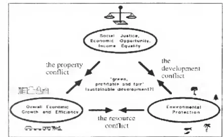
our ecosystems.Campbell
illustratesthebalanceof
these threevaluesinthe
"The
Planner'sTriangle" (Figure 1),a triangle
composed
of
thethree conflictinggoalsforplanning:
economic
growth,equitabledistribu-tion
of
thegrowth,and
environmentalprotection.The
axesof
the triangle are the three conflictsthat
communities and
plannersmust
deal with: the propertyconflict,theresourceconflict,and
thede-"Jie property
^f
\^
conflict '
^f
T^
*grft#n, prcf»taiilp 3rnJ fair"
f
llUltaU-libl* JiMKrot. nwilM/
the
development
conflict
\
;-&*-*&&&&.
theresource
conflict
FigureI. Thetriangle ofconflictinggoals for planning,
and
the threeassociated conflicts. The ideal ofsustainable development is in the
center. Source:
Campbell
1996.velopment
conflict.Campbell
states that thebal-ance
of
all three goals, themiddle of
the triangle,representssustainabledevelopment.
T
hereforeone
of
themethods
to achieve a sustainabledevelop-ment
visionistofindmethods and
ways
tobalancethese goals in plan
making
and
manage
thecon-flicts
(Campbell
1996).The
thirdconcept
of
sustainability."linklocal toglobaland
regionalconcerns",callsfor commu-nities towork
to solve regionaland
global prob-lemsatthelocal leveland
totake responsibility forimpacts theycreateoutside
of
themselves(Berke
200
1).Forthebroadervisionofsustainabledevel-opment
tobesuccessful,communities need
toco-operate with each otherto beginaddressing
con-cernsthatare
beyond
theircapabilityof
solving. Ifwe
continueon
thecommon
"each fortheirown"
view,
everyone
willexperiencethe"tragedyof
thecommons"
scenariowhere
each person pursuestheir
own
self-interest untilthepublicgood
iscom-pletelydestroyed. Regionallevelcooperation
would
greatlyhelppreventthistypeof
tragedy.Commu-nitiescould create external linkages
and
create a regional levelof
decision-making. Regionalgov-ernments
orcommissions
willbeabletosolveim-portant issues that
would
beextremelydifficultorimpossiblefor local
governments
tosolvebythem-selves.
The
second
aspect oftheconcept
is forcom-munitiesandindividualpolluters to
takeresponsibility for theirimpacts
(Berke
2001). Decisionsand
eco-nomic
valuations currentlydo
notfullyaccount forexternalities. In
order to
implement
this conceptinto our plans,
communities
willhave
toreviseplanning techniquesand
tools.Leaderswillhavetoholdthelocal
government and
theresi-dents responsiblefor theiractions
through
making
surethatallexter-nalitiesare
known
beforedevelop-ment
decisions aremade.
Plannersmust
incorporate externalitiesintomarket-orientedtechniques suchas
impact
fees,taxes,and
capital in-vestments.From
the three concepts.Berke
and
Manta-Conroy
derivedsixsustainabledevelopment
prin-ciples.
Each
ofthe principleshasacommon
notionand
can bemeasured
systematically.The
principleshelpthe plannertranslate the vision into practice
and
they allow the plannerto evaluatehow
sus-tainable current practices are.
The
following areBerke and Manta-Conroy"s
operational principles:ronmentalhealth
and
human
dignity.Equitableac-cesstosocial
and
economic
resourcesis essential foreradicating povertyand
in accounting fortheneeds
of
leastadvantaged.5. Polluters
pay
. Polluters (orculpableinter-ests)thatcause adverse
community
wide
impactsshouldberequiredtobearthecost
of
pollutionand
otherharms, with
due
regardtothepublicinterest.1 .
Harmony
with nature.Land
useand
devel-opment
activitiesshould
support the essentialcycles
and
life support functionsof
ecosystems.Whenever
possible,theseactivitiesshouldmimic
ecosystem
processes, ratherthanmodify
them
tofit urban forms.
These
activitiesmust
respectand
preserve biodiversity, as well as protect
and
re-store essential
ecosystem
services that maintainwater
quality, reduce flooding,and
enhance
sus-tainableresourcedevelopment.
2. Livable built
environment
.The
location,shape, density,mix.proportion,
and
qualityshouldenhance
fitbetween
peopleand
urbanform by
creatingphysicalspacesadaptedtodesired activi-tiesof
inhabitants,encourage
community
cohesionby
fosteringaccessamong
land uses;and
supporta sense
of
place to ensure protectionof
any
spe-cial physical characteristics
of
urbanforms
thatsupport
community
identityand
attachment.3. Place-based
economy
.A
localeconomy
shouldstrive tooperate withinnatural
system
lim-its. Itshouldnotcausedeterioration
of
the naturalresource base,
which
serves asacapitalasset forfuture
economic development.
Essentialproductsand
processesofnatureshould be usedup no
more
quickly than nature can
renew
them.Waste
dis-charges shouldoccur
no
more
quickly than naturecanassimilatethem.
The
localeconomy
shouldalsoproduce
builtenvironments
thatmeet
locally de-fined needsand
aspirations. It should createdi-verse housing,
and
infrastructure thatenhances
community
livabilityand
the efficiencyof
localeconomic
activities.4.Equity.
Land
usepatternsshould recognizeand improve
theconditionsof
low-income
popula-tions
and
notdeprivethem
of
basic levelsof
envi-6.
Responsible
regionalism.Communities
should not act in their
own
interests to thedetri-ment
of
the interestsofothers,and
they shouldberesponsible
of
theconsequences of
their actions.Just as individualdevelopersshould besubject to the principlethatpolluters (orculpable interests)
pay.a localjurisdiction hasanobligationto
mini-mize
theharm
itimposes
on
otherjurisdictions inpursuit
of
itsown
objectives(Berke
and
Manta-Conroy2000).
Reasons for Using
theBerke
and Manta-Conroy
Model
Berke
and
Manta-Conroy"s
definitionof
sustainable
development and
theaccompanying
principles providethe best
framework
for anew-planningvision.
Berke
and
Manta-Conroy*s
theoryis both
comprehensive
and
holisticwhile
theprinciples
provide
a practicaland
specificapplication.
Their three concepts strengthen planning so
thatitiscomprehensive,analytical,
and
long-term.This theoryasanoverarching
theme
forplanningprovidesanorganizationalconceptthatbrings
con-sensus
among
planningprofessionalsand
providesguidance
in the practiceof
making
and
applyingplans.
The
underlyingpurposeof
the theory isto protectthenaturalenvironmentand
promote
amore
equitable distribution
of
resources whilecreatingeconomic development
thatbringsvitalityand
liv-abilitytoa
community.
This typeof
visionengages
planningto
have
broad goalsthat thoroughlyad-dressall aspects of ourbuilt
and
naturalenviron-ment.
The
theory's principlescombined
w
ithpub-licparticipationandinputprovidethematerialthat
can be usedtocreatea precise
and
proactiveagenda
for leading
communities
into a livableand
equi-o
z
o
z
m
§
w
o
r~
c
H
O
z
a>
03
<
"0
D
m
O
m
tablefuture.
Methodology
The
Atlantaand
Charlotte metropolitan areaswere chosen
forthe evaluationbecause
they aretwo
cities thatcontinue
toexperience
rapideconomic
growth andaredominated
by sprawlstyledevelopment.
These two
citieshave conditionsthatare very
conducive
to thedevelopment of
sprawlsuch as high growth,
no
naturalhindrances
togrowth
such as the coast or mountains,and
thedominance
of
theautomobile
asthemain form of
transportation.
The
differencebetween
thetwo
isthat they are at different stages in their growth.
Atlanta
isalready
experiencing
serious
repercussions
of
sprawl i.e. highlydegraded
airquality,
heavy
traffic congestion,and
continuedpopulation lossin thecity.Charlotteis atanearly
stagein
growth and
hasnotfullyexperiencedtheseproblems. Leaders in the Charlotte metropolitan
area are trying to
develop
plans thatprevent
Charlotte
from developing
intheway
Atlantahas.The
comparison
of
thesetwo
cities will helpdiscover
how
well theyare incorporatingthe ideaof
sustainabledevelopment
intotheirapproaches
tostopsprawl
and
buildcommunities
thatcontainahighqualityofliving.
The
purposeof
the profile informationgath-ered
on
each metropolitanareaistohighlightsimi-larities
and
differences in the historyand
atmo-spherethat willinfluenceanddifferentiatethe
prob-lems
and approaches
that the cities take.The
profilessetageneral understanding
of
thecitiessothatthese characteristicscan belinkedtothe plans.
Example
I:WithinARC's
2025 Regional TransportationPlan,thepolluterspayprincipleisidentifiedthroughapolicywithin theTransportation EmissionsControlsection.
The
policystates "promotecost-effectiveInspectionand Maintenance(I/M)testingdesignedtominimizeemissionsfromgasolineanddiesel
powered
on-roadvehicles" (AtlantaRegionalCommission
1999).Thispolicyattemptstoensurethatdriversmaintaintheirvehiclestoprevent excessive emissions;thus, thisprinciple isclassifiedasforcing polluters to pay.
Sincedriverswillonly be allowedto usetheirvehiclesifthey passthetest,thedevelopment
management
regulationthatisused withthispolicy iswithinthe"permitted use"category.
The
terminologythatthe plan uses in presentingthe policy is "promote"; therefore the actionis suggestedand notmandatory andtheplanisawarded onepoint.
The
inputted informationisshown
below.Polluters
Pay
POLICY
/.
Land
Use Regs1.2 PermittedUse
Transportation
Code
Pg
Example
2: WithinCharlotte'sCenter City201 VisionPlan, apolicystatedintheurban designsectionsupportsthe livablebuiltenvironmentprinciple.
The
policystates"heightenrequirementsfordemonstrating financinganddesign intentpriortothe issuanceofdemolition permitsforpropertiesdetermined 'locally significant'bytheHistoricLandmarks
Commission"
(CityofCharlotte,MecklenburgCounty,andCharlotte Center CityPartners2000).This policyfulfillstheSD
principlebyprotecting a special featurethatsupports"community
identityandattachment"(Berke2001).The
developmentmanagement
regulationthatisusedisStandardsforRetrofittingExisting Buildings. Sincetheplan uses no mandatorylanguageinpresentingthe policy, theplan isawarded onepoint.
The
inputted informationisshown
below.Livable Built
Environment
POLICY
5. Bldg Codes
and
Stds5.2StandardstorRetrofittingExistingBldas
Urban Design
Code
Pa
I 44
1.
Land
Use Regulation 4. Financial IncentivesDenisty Impact Fees
Permitted use Generalfinancialorotherincentive
Specialstudyzone Reducedtaxation
Sensitivearea overlay Bonuszoning
Setbackbuffer Exaction
Subdivision Land trust funds
Sitereview
Local environmental impact statement 5.Building
Codes
and StandardsStandardsfor
new
buildings2.PropertyAcquisition Standardsforretrofittingexisting
Transferof developmentrights buildings
Acquisition ofland
Acquisition ofdevelopment rights 6 PublicEducation
and
AwarenessLand
bank BuilderworkshopsAcquisitionof developmentunits Publiceducationprogram
Tl
RealEstateDisclosure r—
]
3.CapitalFacilities
2
Phased growth
o
z
Concurrency
m
Locationofcapitalfacilities en
O
Urban service boundary r—
C
Annexation
O
Designofpublicfacilities
2
enro
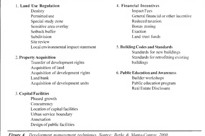
Figure4. Development
management
techniques. Source: Berke&
Manta-Conroy, 2000.5
o
policies,
and
the overallrecommendations
for us- analysisoftheentireplanningdocument
to identifyr
-m
-<
ing sustainable
development
asanapproach
inplanhow
many
timesthe principles areappliedand
ifm
o
making. theyare
mandatory
orencouraged.Theirapplica-m
tionis
shown
throughdifferentdevelopment
man-3D
Through
applying sustainabledevelopment
agement
techniqueswhich
arethe overallapplica-principlestoplans,an understanding can be gained tiontoolsplanningusesto
implement
policies.The
of
how
wellcitiesareincorporatingand
balancing principlepolicy evaluationwill allow planstobeenvironmental,
economic
and
social values.The
measured
basedon
theiradvancement
of
thesus-principlepolicyevaluation
method
usedthe prin- tainabledevelopment
principles.Then
plans canciples ofsustainable
development
for evaluating beanalyzed comparativelyand
asawhole
todeci-how
well plans supportsustainabledevelopment.
pherwhich
principlesarebeingleftoutand which
The
evaluationsprovided empirical evidencethat citiesaremore
activelyadvancing
the concept.isusedto
compare
and
contrast the plansaccord-ingtotheir
promotion of
theSD
principles. Inter-The
first step in the evaluation process is toviews
withkey
stakeholderswere used
toidentify identifythe sustainabledevelopment
principlepro-any
specific context orcomponents
in the devel-moted by
the policiesinthe plan.The
principleisopment
ofthe plan thatform
a basis for the suc- identified basedon
the goal that is linked to thecess or failure
of
the plan topromote
SD
prin- policy or thereasoning forthe policy as it isde-ciples.
The
findingsfrom
thesetwo
steps will pro- scribed in thetextof
the plan.Second
thepracti-vide the informationandanalysisforcreatingoverall cality
of
thepolicyisevaluatedby
determiningifitconclusions
and
recommendations
concerninghow
usesone of
the listeddevelopment
management
well citiesarerepresenting
SD
values. techniques(seeFigure4).The
listof
techniquesisPrinciple Evaluation a
comprehensive
listof
current toolsplannersuse.management
techniqueusedandisaward
additional points ifthetechnique ismandated
ratherthanen-couraged.
Examples
of
themethod
areshown
inFigure3.
Interviews
The
interviewswere conducted
withprofes-sionalsthat
were
involvedin eitherthe creationorimplementation
of
the plan.The
intervieweesranged
from
a planning director to aconsultant.The
questions in the surveywere
created to 1)
gather informationaboutthepolitical
atmosphere
and
supportforthe plan. 2) the special interestthatshaped
the planand
3) the interviewee'sopinionon
the strengthsand
weaknesses.With
thisinsight,theempirical evidence
from
theevaluationson
thesustainable
development
principlescan
becom-pared to the interview information to determine
why
certainvalueswere emphasized
in plansand
why
certain valueswere
avoided. Interviews withkey
stakeholderspresentedimportantinsightsintothe impetus forthe plans.
The
intervieweeswere chosen based on
theirability togive objective
and
conceptualinforma-tion
on
the plan.There were
a totalof
fiveinterviewees.
Each
intervieweewas
askedques-tionsabout
one
ormore
of
the six plans.The
ques-tions
were
focusedon
all threeof
theabove
sub-jects.
Background
of Studied Plans
Atlanta
Plans
The
Atlantaplansthatwere chosen
forevalu-ation
were
ametropolitan land useplan, ametro-politan transportationplan,
and
thecomprehensive
development
plan for the Cityof
Atlanta.These
threeplansform
abroadand thorough view
oftheplanningactions that theregionistakingtocorrect
the
problems
and
enhance
the strengths that aretaking place.
Two
major
factors thathave
a largeinfluence
on
the plans fortheAtlantaMetro
areaare that 1)in 1999. 13counties coveringthe
metro
areadid not
meet
the federal airqualitystandardsand
thereforewere
not eligible for federalhigh-way
transportation fundingand
2) in1996
a ninesquaremile area withintheCity
of
Atlantabecame
a federal
empowerment
zoneand
receives asig-nificant
amount
of
grant fundingand
tax incen-tives to assistlow-income
residentsand
encour-age job development. Both of
these factors areheavily considered in establishingall three plans.
The
Cityof
AtlantaCDP
designedmany
of
itspoli-cies
and
projects in conjunction with theadvan-tages that are contained within the Atlanta
Em-powerment
Zone.The
RegionalDevelopment
Planand
the Regional Transportation Planhave
meet-ing federalairqualitystandardsas
one of
theirtopgoals increating the plans: therefore,
many
of
theirpoliciesreflectthis.
The
AtlantaRegionalCommission (ARC),
theMetropolitan Planning Organization for the
ten-county
Atlanta Region, createdtwo
of
the evalu-ated plans forthemetropolitan area whilethe Cityof
Atlantacreated thecomprehensive
development
plan.
The
ARC
agency
is responsible for carrying out a public participation process to identifyre-gionalgoals
and
createstrategies to attainthegoals.State
and
localauthoritiesusethegoalsand
strat-egiestoguide public investments
and
regulations.The
agency
isan advisoryagency
withno
regula-tory power.
The
agency does have
access to alarge
amount
of
federaland
state fundingwhich
it uses as "the carrot" toencourage
localgovern-ments
toabideby
thestandardsARC
establish. Inaddition to the incentives
ARC
uses, theagency
hasan excellent reputation for understandingthe current
and
futureproblems
that the region willface.
They
are alsoknown
forcreating solutionsthat will allow various municipalitiesto
work
to-gether to alleviate these
problems
and
create ahigherquality
of
livinginthearea.Regional
Development
Plan
ARC"s
RegionalDevelopment
Plan"A
Frame-work
FortheFuture"was
adoptedinOctober
1999.The
1999 version is an updatetoa priordevelop-ment
plan.The
plan presents 14newly
revisedpoliciesintendedtoserve as aguideforfuture
re-gionalgrowth.
The
RDP
"formsthefoundationforexamining
future water supplyand water
qualityissues,providesinsightintopopulation
growth and
ser-vicesprograms,
and
outlinesthe future regionalre-quirementsfor
job
skillstrainingand
economic
de-velopment programs"
(AtlantaRegional
Com-mission-
RDP
1999).The
overall purpose oftheplan is to correct the destructive
growth
pattern that iscurrentlytaking placeand
replace itwithapattern that decreases auto
dependency,
encour-ages higher densities, protects natural areas,
and
enhances
qualityof
living.The
creationof
theRDP
startedwithVISION
2020,a project thatutilizedpublic participationto
create a set
of
development
issues.The
develop-ment
issues are the foundationof
theRDP.
The
RDP
was
also closely coordinated with theRe-gional Transportation Plan
(RTP)
thatwas
beingdeveloped
atthesame
time.This coordinational-lowed
both planstodevelop
policiesthatincorpo-ratedthelanduse/transportationlink.Thislink
al-lows
land use strategiestocomplement
transpor-tationstrategiestoattain
optimum
gains.Thisvitalcoordination allows better usage
and
sustenanceof
a public transportation system, greateropen
spaceprotection,theefficientusageofpublic
mon-ies
and
many
otherbenefits thatwould
notbepos-sible
by
regulatingonlyone
sector.Once
theVISION
planning effortwas
com-pleted in
1996
and
a setof
goal statementswas
established toguidethe
RTP
and
RDP,
ARC
thenanalyzed fourdifferent
growth
scenarios.The
firstwas
ano-buildanalysisthat"assessedexistingand
future transportation conditions,
assuming no
addi-tionalmajor improvements
tothe transportation"(Atlanta
Regional
Commission
-RTP
1999). Thisscenarioindicated thatcongestion
would
increasewhileair quality,mobility,
and
accessibilitywould
continuetodegrade.
ARC
thenanalyzedthreeotheralternatives: 1)thecontinuationofexisting
growth
patternswith increased alternativemodes
oftran-sitalong
major
travelcorridors, 2)focusingfuturegrowth
inexistingdevelopedand
heavilypopulatedareas
of
the Atlanta Region.3) acombination
ofscenarios1
and
2.After considerableresearchand
debate, the taskforces identifiedscenariothree as the preferredoption
and
presented a setof
strate-giestoachievethisgoal.
The
RDP
focusedon
theland use
and
development
alternativesthatwould
achievethisgoal
and
aid thetransportation policiesand
projects.The
RDP
iscomposed
of
14 policies,asetof
land use, transportation,environmental,
and
hous-ing practices,
and
a short sectionon
implementa-tion.
The
policiesareverybroad
and
mostly focuson
encouragingmixed
use,dense development
thattransit can serve.
The
best practices are a verypractical application
of
the policies.These
prac-tices mostly concentrate
on
different designele-ments of promoting
anew
styleand
patternof
growth and development.
Regional
TransportationPlan
ARC's
RTP
is a detailedand comprehensive
policy
document
that sets forth goalsand
strate-gies that
aim
toreducedependence on
single-oc-cupancy
vehicle traveland
promote
alternativeforms
of
transportation.The
RTP
conforms
tothe federaland
state air quality standards formobile
sourceemissions as outlined in the State
Imple-mentation Plan(SIP).
To
meet
theserequirementsthe
RTP
had
todemonstrate
thattheoutlinedstrat-egies
would
reduce expected daily emissions tolessthan
224
tonsof
Nox
and
132 tonsof
VOCs.
The
projected emissionsof
bothof
these fallbe-low
budgetby 2003
withtheimplementationof
theRTP
policiesand
projects.The
RTP
was
produced
using thesame
pro-cess as theRDP,
which
isdescribed above.There
are four transportation goals thatwere
identifiedinthe
VISION
2020
projectand form
the basisof
the
RTP.
The
goalsare: 1)accessibilityand
mobil-ityforpeople
and
goods,2)attainregionalairqual-itygoals, 3)
improve and
maintainsystem
perfor-mance
and
systempreservation,and
4) protectand
improve
theenvironment
and
the qualityof
life.The
nextstep inthe planning processwas
toana-lyze the four different
growth
scenarios for the region.Once
the preferred scenariowas
chosen,the
ARC
staffand
board selected a setof
strate-gies in
accordance
with the2025
Performance
Targets.The
targetsranged
from
40%
populationwithin0.4miles
of
transitto 1.3vehiclehourstrav-eledpercapita.
The
RTP
stakeholdersestablished the targets as acceptableand
desirable standardsthatthe strategiesshould
work
to attainby
2025.The
policiesarecategorizedintoeight categories:z
o
GO
o
r-c
H
O
z
CO
CD
-<
o
m
O
35
new/expanded roadways,
transit, land use.trans-portation
demand
management,
emissionscontrol,environmentaljustice,design,
and
safety (AtlantaRegional
Commission
-RDP
1999).City
of
Atlanta2002 Comprehensive
Development Plan
The
City of AtlantaCDP.
adopted
inAugust
2001, is a lengthy planthat covers a
wide
rangeof
issues.The
purpose of
the plan isto "be usedasa guide forthe
growth and development
oftheCity
and which
will identifyitspresentand
plannedphysical,social
and economic development"
(Cityof
Atlanta200
1).The
wide
rangeof
issueswithinthe plan is divided into sections.
They
includeeconomic
development, housing,human
services, transportation,environmental
facilities, natural resources,historicresources,parksand
recreation,arts
and
cultural affairs, libraries,education, publicsafety,general
government
design,urbandesign, land use,and
a sectionon
specific study areas.Each
of
these sectionscontains
the currentconditions, anticipated future conditions, current
policies,current
programs and
projects,and 2002
CDP
currentprograms and
projects.The
plan alsocontainsthreeattachments: 1)a fifteen-year land
use
map.
2) a water supplywatershed
protectionordinance,
and
3) awetlandprotectionordinance.The
plan's policiesand
projects
areimplemented
throughtheCity'szoningordinance,the subdivision regulation,
HUD
grants,and
economic
development
incentives.The
City'seconomic development
incentives include theAtlanta
Empowerment
Zone
funding, theUrban
Enterprise
Zone
taxabatement and
tax creditprogram,tax incrementfinancing,
and
impactfeeexemptions.
During
the creationof
the plan theplanning departmentreliedheavily
on
the in-depthresearch that
was
conducted by
theBrookings
Institution
Center
on
Urban
and
MetropolitanPolicy
which
was
included in"Moving
Beyond
Sprawl:
The
ChallengeFor MetropolitanAtlanta."The
planningdepartmentreliedon
thisinformationtounderstandtheregional forces
and
effectsthatareoccurring instead
of
justfocusingon
thecitylimits.
The
Brookings
Institute researched intohow
the largeeconomic,
demographic and
policytrends
were
affecting theCityof
Atlantaand
themetropolitanarea.
The
CDP
gives detailedinformation
in asystematic form.
Each
issue is presented with anextensive
amount
of
informationon
the existingconditions.
Then
future projections are presentedand
they arecompared
to determine ifthe needsare met.
Once
needs
are identified the goals are statedandpoliciesarepresentedtomeet
the goals.The
mere
breadthand depthof
theanalysis intheplan
makes
itverystronginaffecting thesocial,economic,
and
physical aspectsof
Atlanta.The
detailed
knowledge
basethat is presented first in eachplanelement
makes
the policiesveryrelevantand
applicabletoaddressingtheseriousproblems.The
strengthof
the plan also lies in the specificpolicies that are applied through
programs and
projects.Each
planelement
ends
with a chartstating the
CDP
program
and
project, thecompletion
yearand
theresponsibleparty.
Charlotte
Plans
The
Charlotte-Mecklenburg
Planning
Commission
is the planningagency
that createsand
monitors all planningactivity in the Cityof
Charlotte
and
Mecklenburg
County.The
agency
has
produced
threeimportant planningdocuments
that createvisions
of
different scopes forguidingdevelopment and
investmentsin theirjurisdiction.The
20
15 Plan.Center
City20
1 Vision Plan,and
the
2025
Transit/LandUse
Planare thethreemost
currentanddefinitiveplansthatforma unified vision
of
where
and
how
Charlotte residentswant
togrow.
These documents
forma significant influenceon
Charlotteand
guidethemany
smallerarea plansthatcontain
more
specific,place-basedstrategies.2015
Plan
The 2015
Plan"Planning
forOur
Future",adopted
inNovember
of 1997. is a productof
anextensivepublic participation processthat
identi-fied the
most
importantcommunity
issues thatneeded
to be addressed.The
creationof
the plan startedwiththe20
15View document
thatupdatedthe
growth
projections to the year2015
and
as-sessedthe current
growth
patterns.With
thisap-proximately 1
50
citizens, identifiedkeyissues,ex-amined
the current statusoftheCounty,and
cre-ated goalsand
objectivesof
how
toachieve"where
they
want
togo"
(Cityof
Charlotte&
Mecklenburg
County
1997).The
citizens identified seven issueareas: landuse
and
design;neighborhoods;parks, recreationand open
space: transportation; region-alism;education;and
economic
development.The
plan isbroken
intosectionsdevoted toeach issuearea.
The
sections start with a descriptionof
the issueareaand
thenstateverybroad goalsinwhich
the citizenswould
liketohavehappen
withinthese issue areasand
thenmore
specific objectives are stated to help achievethe goals.The
last sectionof
theplanis theimplementationstrategy forcar-ryingoutthese goals.Thissectionassignstasks to
different
government
agenciesand
proposesa costestimate
and
sourceof
funds for each issue.The
planisvery
comprehensive
intheissuesitaddressesand
contains a healthy balanceamong
land use.economic,
and
social issues.Even
though
theplanis nota land use plan with
development
policies,theplan "servesasa
framework
and
organizationtool to ensure that priority issues are addressed"
(City
of
Charlotte&
Mecklenburg
County
1997).2025
Transit/Land
Use
Plan
Numerous
privateand
public organizationsworked
togethertoform
arevolutionaryvision fortheCity
and
County.The
plan,adopted
inOctober
of
1998, presentsa largevisionofa strongdown-town
with concentrated,mixed-use
nodes of
de-velopment
intheperipherythatareservedby
lightrailtransit.
The
planisaboldmove
tostopsprawl-ing
development and
createastrongalternative tothe automobile.
As
a land useand
transit plan, itfocuses
on
the physicaldevelopment of
the area.The
feasibilityof
the planwas
strengthened withthe passage
of
the one-halfcent sales tax that issolely
devoted
tothe fundingforthepublic trans-portationsystem.The
overall strategyof
theplan is "tocoordi-nate theplanning
of
landuseand
transittoachievemaximum
benefitsinguidingand
servicingexist-ing
and
future landdevelopment
with transitin-vestments"
(Cityof
Charlotte&
Mecklenburg
County
1998).The
planstatesoverall landuseand
transit
recommendations
that willenablethevisionto be achieved.
Most
of
theserecommendations
aim
to increase transit ridershipand
create adif-ferent
development
pattern in the regionthat willimprove
the qualityof
living.The
recommenda-tions
aim
torevise currentpolicies,plans,and
zon-ing to allow increased densities
and
mixed
useswithinTransitDistricts(TDs).
TDs
are thedesig-nated
nodes of
development
thatwillbe servedby
transit.
To
bemore
precise, the plan divides theregion intofivedifferentcorridors
and
statesspe-cificland actionsforeacharea.
The
planassigns a varietyof
transitmodes
totheareasdepending
on
the area's characteristics.For
example
the planrecommends
busrapidtransitwith bus only lanesfortheIndependence Corridor
due
tothelow
capitalcost per rider for this
low
density stripdevelop-ment dominated
area.Each
sectionends with
phased
implementation steps forthe first5years,6to 1 years,
and
11 to25 years.The
2025
Land
Use/Transit Plan presents abold scenario
of
drasticallychanging
currentde-velopment
policiesand
ordinancestomaximize
the benefits thata largeinvestmentintransitwillcre-ate.
The
plan isdesignfocused withstrategiesforspecific locations in the region.
Even
though
the plandoesnotexplicitlyaddresssocialand
environ-mental issues,the
implementation
of
the"Centersand
Corridors Vision" hasthe possibilityofcreat-ing large social
and
environmentalbenefits.Center
City2010
VisionPlan
Adopted
inMay
2000. theCenter
City2010
Vision Plan is a
comprehensive
plan that isde-voted tothe physical structure
of
the centercity.The
boundaries set forthe centercity areshown
inFigure 16.
The
planwas
produced
throughthreecommunity
workshops
thatinvolvedover700
citi-zens. Inthe
workshops
the participants identifiedavisionstatementthat
would
be thetheme of
the plan:"To
create a livableand
memorable
Center Cityofdistinctneighborhoods connected by uniqueinfrastructure" (City
of
Charlotte.Mecklenburg
County,
and
CharlotteCenter CityPartners2000).The
three goals thatthe citizenswanted
to focuson were
making
theCenter Citymore
viable,liv-able,
and memorable.
The
residents agreed thatthe
most
challenging goalwould
betomake
Char-lottea
more memorable
place.To
make
thecentero
o
I—
c
H
o
Z
01
CD
<
O
m
O
7\
m
city
memorable
theyformed
seven general prin-ciplestoguidethe entire process.Inthe plan theystated "to create a
memorable
city,each
futuredevelopment, program,renovation,funding
initia-tive
and
cityimprovement
should be evaluatedon
itssuccess inachievingthefollowingcriteria:
pe-destrian, mixed, balanced, leveraged, varied, de-signed,
and connected"
cities (Cityof
Charlotte.Mecklenburg
Count),and
CharlotteCenter
CityPartners 2000).
the principlestothecentercitythrough anoverall
new
designofthedowntown
and
throughtargetingspecific locationsforprojectsthat
encompass
theguidingprinciples. Itis
more
likelythatthesespe-cificactionswill
occur
since theplanalso used anintensivepublic participationprocessthat
formed
a strongsupportand
focus forthedowntown.
Findings
The
planisdividedinto fivedifferent sections:land use.
growth and
city form;open
space, parksand
recreation; transportation, streetsand
park-ing; catalyst projects;
and neighborhood
plans.Each
section consistof broad
goals,recommendations
witha
diagram
identifyingexact locationsfortherecommendations,
and
lastlyimplementationsteps.The
goals are actually the applicationof
threeof
the principlestothe specific section.
For
example
thegoals forthe
Land
Use,Growth
and
CityForm
section are to
encourage
amix
of
uses; create abalanced ratio
of
residential units, office space,stores
and
entertainment facilities;and
commit
toa specificdesign inthe
downtown
that isdistinctly Charlotte.Even
though
the plan lacks specificity inde-velopment
policies,theplancreatesguiding prin-ciples forten years into the futureand
states tenpriorityprojectsthat will
make
the centercitymore
memorable.
As
shown
in Figure 16theplan appliesEvaluation
Findings
The
resultsof
the evaluation reveal a clear pictureof
how
plans concentrateon enhancing
thebuilt
environment
tomake
amore
efficientand
enjoyable placeforpeople.
The
livablebuiltenvi-ronment
principleisthe closest principletothe his-toric rootsof
planning field.The
humanistic ideaof
creatingand
manipulatingbuiltstructurestoen-courage
identity, aesthetic appeal, comfort,eco-nomic
productivity,and
efficiencyamong
landuseshas
been
at the coreof
planning since its birth.The
idea that this notion continues reveals plan-ners fascination withthe subject.Results
Once
theevaluationwas
completed
thenum-ber
of
pointsfrom
eachprincipleforeachplanwere
totaled.
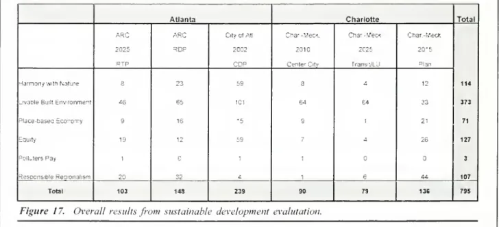
The
results areshown
in Figure 17.The
results for the plans are that the City of Atlanta
Comprehensive
Development
Planscoredthemost
pointsby
averylargemargin.The
ARC
RegionalAtlanta Charlotte Total
ARC ARC City otAtL Char -Meet Char-Week. Char.-MecK
2025 3DP 2002 2010 2025 20-5
.. zc
-CenterCity Trans 'A J "lan
114
HarmonywithNatire 3 23 59 a - 12
UvaoleBuiltEnvronme"t 45 65 1C1 64 64 33 373
Place-basecScoron-y 9 16 •5 c 1 21 71
Equity 19 12 59 7 4 26 127
PollstersPay 1 Q 1 1 3
HesocnsifcieRegionalism 20 32 £. 1 6 44 107
Total 103 148 239 90 79 136 795
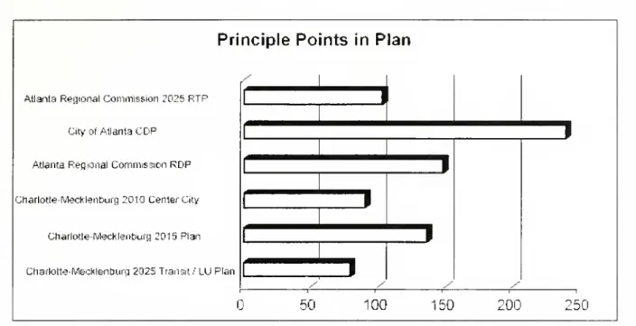
Principle
Points
in
Plan
AtlantaRegionalCommission 2025RTP
City ofAtlanta
CDF
AtlantaRegionalCommission
RDP
Charlotte-Mecklenburg2010 CenterCity
Charlotte-Mecklenburg2015Plan
Charlotte-Mecklenburg2025Transit/LUPlan
i
/
50
100
150
:oo
150o
CO
o
o
z
CO
CD
a
r-m
-<
"D
D
m
o
Figure 18.
A
comparison oftotalscoresfor eachplan.Development
Plan scoredthesecond
most
pointsnomic
issues in thesecommunities"
(Cityof
At-and
theCharlotte-Mecklenburg
2015
Plancame
lanta 2001).The
plan benefitedby
intertwininginthird.
The
Charlotte-Mecklenburg
Transit/Landmany
of
their policies with the federalprograms
Use
Plan scoredtheleastpoints outofalltheplans.and
policies.The
comprehensive
development
plan is theplanthatscoredthehighest
number
of
points.Thisreveals theabilityoftheplantobalancethe
com-petingvalues
of
sustainabledevelopment and
thuscreateaholistic
approach
toplanning.The
Cityof
Atlanta
CDP
scoredvery highpointsinequityand
harmony
with natureand
thusemphasizes
socialand
environmental valuesmore
stronglythan theotherplans.
The 2002
CDP
scoredthemost
points in theequity principle
by
alargemargin.The
plancon-tainedextensive
and
aggressiveprograms
forpro-moting
equity.One
of
the reasons the Citywas
able to
do
this, besidesthe significantamount
of
attention that the City has historically placedon
equity, isthattheCitywas
awarded
anEmpower-ment
Zone
designationin 1994.The
City receiveda grant
award of $250
millionfrom
the U.S.De-partmentof
Housing and
Urban Development.
The
purpose of
the grantis to"empower
selectedin-ner-city
low
income communities and
theirresi-dentsthrough
economic and
community
develop-ment
programs,public safetyprograms,and
socialservice
programs
tosolvedifficultsocialand
eco-An
example
ofapolicywithintheplanthatislinked to the
Empowerment
Zone
is theEmpow-erment
Zone
Down
Payment
AssistanceProgram.
The
program
assistsfirst-timehomebuyers.
withinthe
empowerment
zone, withup
to80%
of
theirdown
payment.
Another
example
of
an equity policythatwas
included inthe
2002
CDP
isdevelopment
feeex-emptions.
The
policy states that developerswho
arebuilding affordable
housing
unitsoreconomic
development
projects areexempt
from
thepay-ment
of development
impact fees. Eligibleeco-nomic
development
projects are projects locatedwithin designated
low-income
areas.The
2002
CDP
planalsowent
intogreatdetailon
environmentalpolicies,which
directlysupportedthe
harmony
with natureprinciple.The
plancon-tained specific policies that
aim
toprotect natural resources.These
policies rangefrom
permitteduses withinthe subdivision regulations to
educa-tionalprograms.
An
example of
apolicyis"restrictrecreationalelementsthatprotect
and
preservetheresource"(Cityof Atlanta
200
1).Another example
isthepolicythat states"support
and promote
op-portunitiesforestablishingconservationeasements
as authorized in Section
10-2044 of
the Cityof
AtlantaTree
Ordinance"
(Cityof
Atlanta200
1).There
arenumerous
policieswithin the planthatsupportequity
and
naturalresources.The
planalsorepresents other
SD
values through separatesections
on economic
development,transportation, historicresources, landuseand
urbandesign.The
planthatscoredthesecond
highest pointsis the
ARC
RegionalDevelopment
Planwhich
despitescoringa large
amount
pointsinthe livable builtenvironment category
also significantlystressedregionalism,environment,
and
economy.
The
plancoversallof
theSD
principlesexceptforthe polluterspayprinciple.Besidesthe livablebuilt
environment
principle, the plan scored high pro-portionallyintheharmony
withnature,place-basedeconomy, and
responsibleregionalismprinciples.The
plan'sconciseformatstartswithpolicies, statesbestpractices foreachpolicy area,and ends
with a section
on
implementation. Best practiceswere
not used byany of
the other plans in the study. Best practices arean excellentmethod
forrevealing
how
policiesshould be appliedand
made
intoactionsteps.
Many
of
theseaction stepsillus-trate
how
theSD
principles are representedand
supported within the plan. For
example
the planscored relativelyhigh inthe
harmony
with natureprinciple.
The
policy relatedtoharmony
with na-tureprincipleintheplanispolicy 10:protectenvi-ronmentally sensitive areas.
The
policy is veryvague
until it isbroken
down
into bestenviron-mental practices.
There
areeleven best practicesthatexplainexactly
what
areastoprotectand
how
to best protect them. Principle three is to
"pre-serve patchesofhigh-qualityhabitat,as large
and
circular as possible, feathered at the
edges
and
connected
by
wildlife corridors,stream corridors offergreat potential"(AtlantaRegional
Commis-sion-
RDP
1999).Thisprincipleexplainswhat
ar-easthe local
governments
should attempttopro-tect
and
how
todesignthe protection areas.Prin-cipleeight isto"detain runoff with open, natural
drainage systems,the
more
naturalthesystem
themore
valuableitwillbeforwildlifeand
waterqual-ity"(Atlanta Regional
Commission
-RDP
1999).These
principlesshow
how
development and
pres-ervationeffortsshouldmimic
ecosystemprocesses,which
is exactlywhat
theharmony
with natureprinciple advocates for. Therefore the best
prac-tices section
was
akey element
within the planthat revealed
how
the policies supportSD
prin-ciples.
The
planthatscoredthe leastamount
of
pointswas
themost
specialized plan.The
Charlotte-Mecklenburg
2025
Transit/LandUse
Plancontaineda large
amount
of
informationand
policiesbuttheywere
almost all concentratedon
making
a betterfit
between
peopleand
theurbanform, livablebuiltenvironment
principle,with verylittleconcern
fortheenvironment, regionalism orequity.
The
focusof
the planwas
on promoting
thecenters
and
corridorstheme
tothe public.The
planfocuses
on
how
thismajor
public investmentwillbe designed
and
sited. Therefore the majorityof
the plan is
composed
of
how
the land useregula-tions surrounding
each
corridorwill bechanged,
what
typeof
transitsystem
will be developed,thephasing
of
the system,costs,and
issuesand
stepsinvolved.
The
planstresseshow
accessibilityand
mobilitywill increase
and
how
quality residentialand
officedevelopment
surrounding the stationswill occur.
The
plan avoids integratingany
other values or concerns.The
livablebuiltenvironment
principlerepre-sented
81%
of
theSD
principleswithin the plan,whilethe equity
and
harmony
withnature principlescombined
represented10%
of
theSD
principleswithintheplan.
There
arenumerous
proposedpoli-cieswithinthe planthatsupportcreating a livable
builtenvironment.
Most
of
these dealtwitheitherthe urban design or the transportation facilities.
Some
examples of
theseproposed
policiesare cre-atingtransitdistricts(TD)
thathave:minimum
den-sities, density
bonuses
for clusterdevelopment,
accessoryapartmentsallowedofright,
and
stream-linedpermitprocesses.
Another proposed
policyis"creatingincentives(includingtaxbreaks)for
fa-cilitiesorprovideotherdefinabletransitsupporting
features" (CityofCharlotte
&
Mecklenburg
County
1998).There were
onlyafew
principles or policies that dealt with equity or protecting naturalre-sources.
Some
of these are"added
servicesby
theDepartment of
SocialServicesto transport the elderlytoand from non-medical
tripsand
thedis-abledtojobs
and
increasedspecializedtransitser-vice for the disabled-accessible buses" (City
of
Charlotte
&
Mecklenburg
County
1998).The
onlyproposed
policyforenvironmentalprotectionwas
density
bonuses
for clusterdevelopment
within-creased
open
space.There
were
a greatnumber
of
opportunitieswithintheplantoaccountforsocial,
environmen-tal,
and
regional valuesand
create strategies toprotect each oftheseelements but
none of
theseopportunities
were
takenadvantage
of.For
ex-ample, the plan could
have
recommended
meth-ods
forpreventingthe centersand
corridorsfrom
encouraging development
inenvironmentallysen-sitive areas.
The
plan couldhave
created astrat-egyforcreating
economic development
withinlow-income
neighborhoods.The
plan couldhave
alsoidentified
ways
to preventlow-income
residentssurrounding proposedtransitstops
from
beingdis-placed.
There
were
agreatnumber
of missed
op-portunitiesinthisplan.
forequity
and
urbanenvironmental protectionand
cleanup.
The
ARC
Regional
Development
Planused best practicesto
exemplify
how
the policiesshould be applied.
The
plans thatperformed
theworstinthe principlepolicy
examination were
theplansthat
were narrowly
focusedon development
and
didnot includeany
typeof
method
forrepre-senting othervalues.
The
principlepolicyexamination
revealsthatplanners
and
their plansmust
create holisticand
creative strategies that
move
beyond
the fixationwith buildingbetter structurestoinfluencing
pro-cesses
and
social structures.As
shown
throughthe
narrow
scopethat plans use, planners'under-standing
of
all the aspects that can be positivelyaffectedthroughtheplanningfieldisnotfully real-ized.Planning has ignoredthe effect thatplanscan
have
on
the socialand
economic
realm whileal-most
completely
emphasizing
development
ap-proaches that
make
the builtenvironment
more
compatible
to people.The more
planningmoves
beyond
itshistoricparametersintocreatively work-ingtosolvesocietalproblems
holistically.themore
thesustainable
development
philosophywillmate-rializeinourcommunities.
Interviews
The
followingisasynopsisof
theinformationgathered inthe interviews:
D
z
o
z
m
s
CfJ
o
r
-C
H
O
z
w
CD
<
"0
m
O
Overall
Plan Evaluations
The
results forthe principles are that theliv-ablebuilt
environment
principlewas
promoted
inthe plans significantly
more
thanany
otherprin-ciple.
The
livablebuiltenvironment
principleac-counted
foralmost halfof
all the principlespro-moted
inthe plan.Each
of
theotherprinciplesac-countedfor
16%
orless inthe plans.The
polluterspay
principlerepresented lessthanone
percentof
thesustainabledevelopment
principles.These
re-sults are consistent with thecomprehensive
planevaluation results
from
theBerke and
Manta-Conroy
studycompleted
in2000.The
plansthatbalancedmore
SD
valuesuseda specific
method
todo
this.The 2002
CDP
useda federalprogram
that provided the resourcesand
momentum
fordevelopingpoliciesand
strategiesCity
of
Atlanta2002 Comprehensive
Develop-ment
Plan
The
plan isamandated
yearly update fortheCity
of
Atlanta.The
plan containsabroad baseof
support including multiple
governmental
depart-ments,citycouncil,
and
theneighborhood
planningdistricts.
The main
issues addressed in the planare gentrification.urban design
and
land uses,and
development
plans fortheEmpowerment
Zones.The
strategy forthese issues areto use subsidies,densitybonuses,etc. toprovideincentives for
af-fordable housing
and
landuse controls(J. Heath,personal interview.
March
12.2002).The 2002
CDP
scored the highest overall inthe
SD
principles.The
plan alsocontained the highestproportionofpointsdevotedtotheequity principle
and
thehighestproportionofpointsdevotedtothei