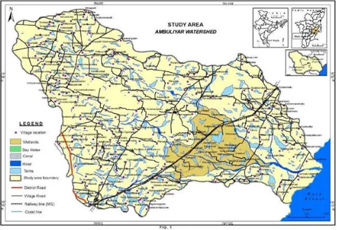
Land use land cover change detection using remote sensing and gis techniques A case study of ambuliyar watershed in 2003 and 2012
Full text
Figure
Related documents
The present paper has argued that excessive general impairment of gene expression can be expected to manifest as abnormality of behaviour and appearance, with certain
This layer consist of the core IPV6 network of 4G and other heterogeneous access networks such as GSM (Global System for Mobile communications), CDMA( Code Division
Summary of joint analysis of variance for plant height (PH, cm), average boll weight (ABW, g), lint percentage (LP, %), seed cotton yield (SCY, kg/ha), fiber length (FL, mm),
Using mass equivalent and stiffness of beam and spring, we can calculate natural frequency of the system having Static deflection of 25mm.. Mass equivalent of the system
The results reveal that CNT-CdSe composite exhibit excellent photocatalytic activity for degradation of MB solution under visible- light irradiation.. Authors
Wu Z, Dong F, Zhao W, Wang H, Liu Y, Guan B: The fabrication and characterization of novel carbon doped TiO 2 nanotubes, nanowires and nanorods with high visible light
CpGs whose modi fi cation levels negatively correlated with gene expression levels were signi fi cantly enriched in 5 9 ends of transcripts (Figure 3C, Figure S2 C, and Table S3
ABSTRACT: The present paper presents the results of an experimental investigation carried out to study the effect of Hydrochloric acid on High performance concrete with
