The London School of Economics and Political Science
Essays in planning policy and urban economics
Elisabetta Pietrostefani
Declaration
I certify that the thesis I have presented for examination for the PhD degree of the London School of Economics and Political Science is solely my own work other than where I have clearly indicated that it is the work of others (in which case the extent of any work carried out jointly by me and any other person is clearly identified in it).
The copyright of this thesis rests with the author. Quotation from it is permitted, provided that full acknowledgement is made. This thesis may not be reproduced without my prior written consent.
I warrant that this authorisation does not, to the best of my belief, infringe the rights of any third party.
I declare that my thesis consists of 58,100 words. (excluding appendices and literature references).
Statement of conjoint work
Paper I “The politics of conservation planning: a comparative study of urban heritage making” is joint work with Dr. Nancy Holman. My contribution to this research includes work relating to: framing the research question; review of institutional frameworks, theories and existing literature; review of legislative documentation; carrying out interviews and related fieldwork, data analysis; write up of paper. I presented the research at the AESOP Annual Conference 2017 and the LSE Urbanisation, Planning and Development Seminar 2017.
This statement is to confirm I contributed a minimum of 50% of this work as agreed by the undersigned.
Nancy Holman
Paper III “The economic effects of density: a synthesis” is joint work with Dr. Gabriel
Ahlfeldt. Paper III was based on work on the effects of compact urban form done for the OECD (Organisation for Economic Co-operation and Development) and the WRI (World Resources Institute). Our subsequent research paper significantly developed on the original report both theoretically and empirically. My contribution to this research includes work relating to: structuring the theoretical framework of the research question; review of existing literature; research design; data collection, collation and preparation; statistical analysis; write up of paper. I presented the research at the Urban Economics Association 7th European Meeting 2017 and the LSE Work-in-Progress Seminar 2018.
This statement is to confirm I contributed a minimum of 50% of this work as agreed by the undersigned.
Gabriel Ahlfeldt
Statement of use of third party for editorial help
Abstract
This thesis consists of four independent chapters. Although the chapters are distinct works, they are related by their focus on urban policy and aim to contribute to the understanding of how planning policies and urban development affect specific
outcomes in space. The chapters can be divided into two distinct parts. The first part comprises two studies on conservation planning. The first chapter investigates the complexities at play between conservation planning systems, their applications and how these vary between contexts. Based on a survey of conservation planning systems in 5 countries, focusing on 5 city case-studies, it considers how conservation compares
between planning systems of the Global North and Global South and what this suggest about heritage value. The second chapter exploits the Italian context to examine to what extent non-compliance undermines conservation effects given that despite stringent planning regulation, the conditions of the urban environment vary widely
throughout Italy, including within protected areas. This study is closely linked to the urban economics literature through an explicit consideration of housing markets and spatial issues.
The second part of this thesis comprises two further chapters that focus on the effects of two distinctly urban occurrences: economic and morphological density. The third chapter investigates the costs and benefits of a widely supported policy paradigm:
‘compact urban form’. It asks to what extent even higher densities within cities are
desirable by assessing the effects of density on a broad range of outcomes ranging from wages, innovation, rents, various amenities, the cost of providing public services, transport- and environment-related outcomes to health and wellbeing.
The final chapter focuses on deregulated planning using Beirut, Lebanon as a case-study
given the city’s conspicuous transformations which have dramatically altered the city’s
landscape, housing stock, and people-space relations. This chapter specifically investigates how morphological densification affects values residents attach to both
Contents
Abstract _________________________________________________________________ 4
List of Tables _____________________________________________________________ 7
List of Figures ____________________________________________________________ 9
Acknowledgements _______________________________________________________ 11
1 Introduction ________________________________________________________ 14
1.1 Overview of Thesis _______________________________________________ 17 1.2 Methods and Data ______________________________________________ 23 1.3 Themes and Overall Contributions _________________________________ 27 1.4 Limitations and Extensions to the Research _________________________ 29 1.5 Policy Implications ______________________________________________ 30 1.6 References ____________________________________________________ 31
2 Paper I: The politics of conservation planning: a comparative study of urban heritage making _________________________________________________________ 35
2.1 Introduction ___________________________________________________ 35 2.2 Conservation planning in the North: England (London), France (Paris) and Italy (Milan) _________________________________________________________ 46 2.3 Conservation planning in the South: Lebanon (Beirut) and Brazil (Rio de Janeiro) _____________________________________________________________ 69 2.4 Conclusion ____________________________________________________ 87 2.5 References ____________________________________________________ 89 2.6 Appendix: The politics of conservation planning ______________________ 99
3 Paper II: Conservation Planning and Informal Institutions __________________ 100 3.1 A story of heterogeneity ________________________________________ 100 3.2 Data and Institutional Setting ____________________________________ 105 3.3 Empirical Framework ____________________________________________ 113 3.4 Estimation Results ______________________________________________ 118 3.5 Conclusion ____________________________________________________ 131 3.6 References ____________________________________________________ 132 3.7 Appendix : Conservation Planning and Informal Institutions ___________ 138
4.3 The evidence base _____________________________________________ 169 4.4 Density elasticity estimates in the literature _________________________ 173 4.5 Original density elasticity estimates _______________________________ 178 4.6 Recommended elasticity estimates ________________________________ 181 4.7 Monetary equivalents __________________________________________ 183 4.8 Conclusion ___________________________________________________ 189 4.9 References ___________________________________________________ 190 4.10 Appendix : The economic effects of density: A synthesis ______________ 194
5 Paper IV: A permanent (re)construction site? Changing Urban Form and Resident Value of Urban Amenities ________________________________________________ 270
List of Tables
Paper I
Table A1 List of Interviews ... 99
Paper II Table 1 Descriptive Statistics ... 119
Table 2
Overall average effects ... 121
Table 3
AB effect on price premiums ... 128
Table 4
Neighbourhood Level estimates ... 130
Table A1 Content of the ads dataset ... 146
Table A2 Summary Statistics ... 150
Table A3 Summary of variables by LA and HC: price, structural, social and urban environment tendencies. ... 151
Table A4 Comparison of mean sales between by urban heritage areas and geographical location ... 152
Table A5 Baseline results ...155
Table A6 Distances ... 156
Table A7 First Step full estimates ... 157
Table A8 Abusivism’s effect on price premiums – full regression unweighted ... 158
Paper III Table 1 Variation in density ... 165
Table 2
Distribution of analyses by attributes I ... 172
Table 3 Density elasticity estimates in the literature ... 175
Table 4
Meta-analysis of density elasticity estimates ... 178
Table 5
Original elasticity estimates ... 180
Table 6
Recommended elasticity estimates by category ... 183
Table 7 Present valuea of a 1% increase in density I: Category-specific effects ... 185
Table 8
Present valuea effects of a 1% increase in density II: Accounting ... 188
Table A1 Organisation of keyword search ... 195
Table A2 Evidence base by collection stage and research topic ... 198
Table A3 All analyses vs. elasticity estimates sample ... 199
Table A4 Adjusted citations by paper vs. Scopus journal measures ... 203
Table A5 Citation measures vs. scientific methods scale ... 204
Table A6 Estimates of the elasticity of density with respect to population ... 208
Table A7 Estimates of the elasticity of density with respect to population by country 209 Table A8 Estimates of the density elasticity of construction costs I ... 215
Table A9 Estimates of the density elasticity of construction costs II ... 216
Table A10
Estimates of the density elasticity of construction costs ... 219
Table A11 Average density elasticity estimates- high-income and non-high-income 225 Table A12
E
lasticity estimates of patents per capita ………...226Table A13
Elasticity estimates of broadband ………...227
Table A15 Elasticity estimates of Gini coefficient ... 228
Table A16 Elasticity estimates of poverty rate ... 228
Table A17 Elasticity estimates of homicides p.c. ... 229
Table A18 Elasticity estimates of vegetation density density ... 229
Table A19 Elasticity estimates of green area density density ... 230
Table A20 Elasticity estimates of green area per capita density ... 230
Table A21 Elasticity estimates of air pollution concentration ... 231
Table A23 Elasticity estimate of speed ... 233
Table A24 Elasticity estimate of speed ... 234
Table A25 Elasticity estimate of standardised mortality rate ... 234
Table A26 Elasticity estimate of life expectancy at birth ... 235
Table A27 Elasticity estimate of mortality in transport p.c. ... 235
Table A28 Elasticity estimate of subjective well-being ... 236
Paper IV Table 1 Summary Statistics... 283
Table 2
Results of Neighbourhood Belonging logit analysis ... 293
Table 3 Respondent’s reasons for not making WTP bids ... 297
Table 4
Results of WTP logit analysis ... 299
Table A1 Final Sample ... 314
Table A2 Statement ... 316
Table A3 Survey questions ... 317
Table A4 Other Summary Statistics ... 320
List of Figures
Paper I
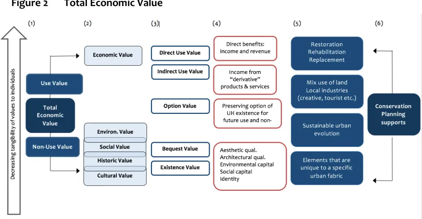
Figure 1 Intrinsic and economic values ... 44
Figure 2 Total Economic Value ... 45
Figure 3 London ... 58
Figure 4 ‘Grand Paris’ and Central Paris ... 60
Figure 5 Milan ... 61
Figure 6 Rio de Janeiro ... 79
Figure 7 Beirut ... 80
Paper II Figure 1 Examples of the Italian conservation planning system ... 108
Figure 2 Evolution of un-authorised vs. authorised building ... 111
Figure 3 North-South divide in non-compliance ... 112
Figure 4 Distribution of house prices offers by price ... 120
Figure 5 Discontinuities in Prices at Historic Centres boundaries by AB rates ... 122
Figure 6 Discontinuities in Prices at Landscape Area boundaries ... 123
Figure 7 Border Price Premium versus Non-Compliance Measures ... 124
Figure 8 Summary of border effects ... 126
Figure A1 Evolution of Landscape Area designation by year ... 140
Figure A2
Landscape areas per Region ... 141
Figure A3 Evolution of Illegal Building by Geographical location ... 142
Figure A4
Abusivism Policy map and comments ... 142
Figure A5
Examples of posts ... 144
Figure A6
Example of geo-localised location of one advert ... 144
Figure A7
Insert Image of location of posts ... 145
Figure A8
55 provincial capitals ... 147
Figure A9
LAs, HCs and Census Unit Boundaries ... 149
Figure A10
Visualising border discontinuities ...153
Paper III Figure 1 Distribution of study period and quality of evidence... 172
Figure 2 Normalised elasticity estimates vs. publication year ... 174
Figure 3 Distribution of normalised elasticity estimates by attributes ... 176
Figure A1 Cumulated citation counts vs. years since publication ………..201
Figure A2
Google Scholar vs. Scopus adjusted citation indices... 202
Figure A3
Quality measures: Methods-based vs. citation-based by discipline ... 205
Figure A4
Population vs. population density ... 206
Figure A5
Elasticity of density with respect to population ... 208
Figure A6
Distribution of buildings in micro-data by number of floor ... 211
Figure A7
Height, construction cost, and density within metropolitan areas ... 212
Figure A8
Household accommodation by structure ... 218
Figure A9
Density, dwelling type, and the cost of construction ... 218
Paper IV
Figure 1 Sampling grid ... 280
Figure 2 Neighbourhood Perception... 285
Figure 3 Building Conditions ... 287
Figure 4 Architectural amenities and sidewalk descriptive analysis ... 289
Figure 5 Average Neighbourhood Belonging ... 292
Figure 6 WTP by neighbourhood and BC rate... 295
Figure 7 WTP Predicted Probabilities ... 298
Figure 8 WTP to improve sidewalks ... 298
Figure A1 Open Spaces in Hamra (Ras Beirut) ... 307
Figure A2
K-densities of constructions according to number of new constructions 309 Figure A3
K-densities of constructions according to area of new constructions...309
Figure A4
Number of new constructions by year brackets ... 310
Figure A5
Defining Ras Beirut ... 311
Figure A6
Defining Mar Mikhael ... 311
Figure A7
Sampling Ras Beirut ... 313
Figure A8
Sampling Mar Mikhael ... 313
Figure A9
Buildings Surveyed Ra Beirut 2009 & 2019 ...315
Figure A10
Buildings Surveyed Mar Mikhael 2013-2013 ...315
Figure A11
Images building change ... 318
Figure A12
Images Sidewalk change ... 318
Figure A13
Safety, Stress, Happy, Satisfied ... 320
Figure A14
Building Condition ... 321
Acknowledgements
The PhD has been a challenging and enriching journey. I am grateful for the countless learning opportunities this journey has given me. I never thought I would have gained so many skills, which all started when my supervisors suggested I pursue an interdisciplinary PhD across the Economic Geography and Urbanisation, Planning and Development clusters.
Over the course of writing my PhD I have been supported by many people whom I wish to thank here. First, I thank my supervisors Nancy Holman and Gabriel Ahlfeldt for their
constant support. Nancy’s insightful comments and suggestions have always helped me
refocus my work, and her guidance along the way has been invaluable, especially in the most frustrating moments of the process. Gabriel, both as a co-author and a supervisor, has played a huge role in my development as an academic and in my understanding of urban economics; I am immensely grateful for his ideas and input. I would also like to
thank Christian Hilber who has made many important suggestions both in meetings and seminars over the years, and Mona Fawaz, for having been a huge inspiration, which pushed me to run a large-scale household survey on the ground in Beirut. Moreover, I would like to thank the LSE for supporting my thesis with a full LSE PhD Studentship.
For each individual chapter, I have gathered comments and suggestions from many individuals in numerous seminars and conferences and I am very grateful to everyone who has ever commented on my presentations or working papers. Special thanks for
each of the chapters are as follows.
For Paper I, I would like to thank all the interviewees who participated in the study, thereby greatly enriching the analysis. I also thank seminar participants in Gothenburg
(AESOP 2018), London (LSE Economic Geography WIP) and London (Writing the World Seminar), in particular Austin Zeiderman, Alan Mace, Claire Mercer and Megan Ryburn for valuable feedback.
For Paper II, I would like to thank my supervisors, Gabriel Ahlfeldt and Nancy Holman, for their guidance throughout the various research stages of this paper. I would also like to thank Christian Hilber and Olmo Silva for their support and advice. I also thank
Erica Pani for more general comments and suggestions. For this paper special thanks also goes to my husband Nicolas, as this paper would not have been possible if he had not one Sunday afternoon taught me how to scrape data when I thought all was lost.
For Paper III,I acknowledge the help of 22 colleagues who contributed by suggesting relevant research, assisting with quantitative interpretations of their work, or providing additional estimates, including David Albouy, Victor Couture, Pierre-Philippe Combes,
Paul Cheshire, Gilles Duranton, Patrick Gaule, Christian Hilber, Filip Matejka, Charles Palmer and Abel Schumann. I also thank conference participants in Bochum (German regional economist meetings), Barcelona (IEB workshop), Copenhagen (UEA), New York (UEA) and in particular David Albouy, Felipe Carozzi, Paul Cheshire, Jorge De la Roca, Pierre-Philippe Combes, Gerard Dericks, Steve Gibbons, Stephan Heblich,
Christian Hilber, Walker Hanlon, Hans Koster, Andrei Potlogea, William Strange, Olmo Silva, Jens Südekum, Sevrin Waights, Jordy Meekes and two anonymous referees for more general comments and suggestions. This work was financially supported by the OECD and the WRI.
For Paper IV,I would like to thank my supervisors, Nancy Holman and Gabriel Ahlfeldt, for their guidance, especially in the survey and sampling conception, and the participants of the LSE Urbanisation, Planning and Development seminar, especially
Sylvia Chant, Austin Zeiderman and Ryan Centner, for their comments. I thank researchers and activists in Beirut who guided me at different stages of the project, including Mona Fawaz, Robert Saliba, Mona Khechen and Public Works Studio. Special thanks to Mona El Hallak, Hayat Gebara and the AUB Neighbourhood Initiative for being such wonderful hosts for the duration of the data collection and for providing much
help and guidance. This research would not have been possible without Mariam Bazzi, Mariam Dandachi, Mikhael Daher, Ghadir Ghamrawi, Aya Itani, Diala Makki, Aline Tashjian and Yara Younes and their excellent research assistance. This was financially supported by the Royal Geographical Society (with IGB) and the London School of
Economics RUPS Discretionary Travel fund.
To my fellow PhD colleagues, those in my cohort, those who finished before me and
those who started after me, in particular the ‘Econ Geo Latinos’, Eduardo, Alexandra
I dedicate this work to Nicolas, who has been there for me at every stage, pushing me to expand my horizons, embrace technology and giving me so much happiness along the way.
1
Introduction
If we agree, like many scholars do (Boyko & Cooper 2011; Smith 1978; Storper & Manville 2006; OECD 2010), that living in urban areas provides something valuable to an increasing number of people across the globe, then understanding issues that impact
cities becomes paramount.1 The question then is one of perspective. Many different disciplines tackle urban questions, each using its own viewpoint. This thesis approaches the topic from the theoretical underpinnings of both urban planning and urban economics, to support the contention that interlacing both disciplines provides a fuller
picture of urban processes and can improve the implementation and adaptation of urban policies.
Urban planning has been advocated as ‘critical thinking about space and place as the
basis for action or intervention’ (RTPI 2004). Urban planning is argued to ground knowledge in sociospatial processes, and cement critical thinking about these processes (Friedmann 1998). Making contributions about spatial interrelationships is, however, common to many geographic disciplines. What is often, if not exclusively,
characteristic of planners is specifically seeking to connect sociospatial knowledge to forms of action in order to bring about change in the public domain (Davoudi & Pendlebury 2010; Friedmann 1987). It is this interventionist nature of planning which underlines its normative dimension and brings the issues of values to the foreground.
Urban economics also tackles urban questions, using economic theory and applied economic methods to study cities and their development. In an urban economic model, individuals and firms are assumed to behave rationally, choosing locations based on
costs and benefits. Urban economic models assume that markets – in which agents interact – are in spatial equilibrium, where prices adjust to ensure that supply equals demand for each location. Such models are then used to predict how urban areas function, and in many cases reveal what individuals consider valuable within their cities.
Data on factors such as house prices, wages and firm performance2 are analysed to understand differences in urban economic performance and the potential effects of urban policy. Housing and land markets are key as they reveal differences across
1Today, more than 50% of the world’s population live in urban areas (United Nations 2014). This
share is expected to reach 70% globally by 2050, with 86% in OECD countries (OECD 2010) and more than 90% of new urbanities located in low-income countries (United Nations Population Fund 2007).
locations. Real wages inversely mirror amenities, while house prices capture amenity differences at local level after controlling for housing quality and wages. Locations with high levels of amenities, such as transport access, good schools or access to green spaces, will thus have high prices.
Urban planning and urban economics frequently seem to be at odds. Planners often think economists are too narrowly focused on productive cities and prices, while
economists often consider planners attach too little importance to real world markets
and focus too narrowly on their contexts of study.3 The role of planners is tied to adding value to the particulars of place, and although place matters to urban economists, it is
seldom their area of focus. Divisions are also increasingly marked by the adoption of qualitative analytical methods by urban planners and quantitative statistical approaches
by urban economists, often argued as antagonistic by one discipline or the other.4 These
divisions are more widely present in wider geography, and have stimulated debate on the epistemological values geography should achieve (Overman 2004; Brooks et al.
2012; Rodríguez‐Pose 2001). Such methodological and epistemological debate is not unique to geography. Disciplines such as political science have experienced long-running debates about the trade-offs between statistical ‘large-N’ analyses and in-depth
‘small-N’ approaches (Lieberman 2005).
Brooks et al.’s (2012) Handbook of urban economics and planning attempted to
underscore the fruitfulness and importance of opening pathways of communication between economists and planners. This thesis contributes to this call. Although these disciplines differ in their approach in terms of methods and sometimes in terms of philosophy, this thesis supports the consideration of their mutual interests as their objectives are in many ways complementary. While economists often talk about cause
and effect (what is – positive economics), many applied urban economists also express normative judgements following their evaluations in an effort to advance policy (what ought to be – normative economics). The latter ties into planning’s normative
dimension, supporting spatial policies or urban interventions to better urban living. Both urban economists and planners thus work towards an improved implementation
of urban policy and both are often interested in socio-economic and environmental
3 Although it must be noted that planning education has made considerable efforts to
incorporate understanding of economic trends in city growth and sharper appraisal of competitive urban land uses, starting with Harvard in the 1930s (Davoudi & Pendlebury 2010).
4 One of the greatest challenges within my PhD ‘process’ has been understanding both
goals. While urban economists assess general patterns (large-N) and the essential economic logic of a situation, planners are usually concerned with place-making issues in one or a few case-studies (small-N). Planning can therefore offer an important substantive contribution to urban economics analysis, while urban economics is necessary to provide a reality check on the claims planners make about the overall
effects of urban policies and development.
In an effort to help overcome methodological and epistemological deadlocks, this thesis also calls for the mixed use of both quantitative and qualitative research methods. While the chapters within it are distinct works, they use quantitative, qualitative and mixed methods to contribute to the understanding of how planning policies and urban development affect specific outcomes in space. This thesis rejects
the view that qualitative and quantitative research techniques are incompatible and instead follows methodological pluralism – that is, the use of different techniques to uncover different facets of the same social phenomenon (Johnson et al. 2007; Greene
2007; Elwood 2010).5 The interdisciplinary approach of this work presents an
opportunity to help achieve a more complete picture, since it incorporates elements that might not be taken into account if one were to adopt a conceptual lens which relied entirely on one discipline. It predominantly traverses the disciplines of urban planning
and urban economics but is also tied to other fields of study, including planning law, development studies, conservation studies and environmental psychology.
The remainder of the introduction is organized as follows. Section 1.1 presents an
overview of the thesis. Section 1.2 discusses the methods and data used in the thesis papers. Section 1.3 presents the common themes running through the different papers while sections 1.4 and 1.5 give an overview of limitations and policy implications.
5 Despite the significant divisions described, Elwood (2010) argues how social scientists have
1.1
Overview of Thesis
1.1.1
Structure of the thesis
This thesis consists of four independent papers.
Paper I: The politics of conservation planning: a comparative study of urban heritage making
Paper II: Conservation planning and informal institutions: heterogenous patterns in Italian cities
Paper III: The economic effects of density: a synthesis
Paper IV: A permanent (re)construction site? Changing urban form and resident value of urban amenities
Although the chapters are distinct works, they are related through their focus on urban policy and their aim of contributing to the understanding of how planning policies and urban development affect specific outcomes in space. The papers investigate urban
policy from a legislative standpoint, through meta-analytic research, and test theoretical predictions in empirical settings by examining data on individuals and spatial market prices. The chapters can be divided into two distinct parts. The first part comprises two studies on conservation planning, while the second part encompasses two further chapters focusing on the effects of two distinctly urban occurrences:
economic and morphological densification. In the following I provide brief summaries
of each paper’s context, contribution, method and results.
Part I
Paper I: The politics of conservation planning: a comparative study of urban heritage making
My first paper, co-authored with Nancy Holman and currently under review in Progress in Planning, investigates the complexities at play between conservation planning
structures, their applications and how these vary between contexts. Urban heritage is the category of heritage that most directly concerns the environment of every individual. Conservation, or the integration of the built historic environment, is typically
does conservation compare between planning systems of the Global North and Global South and what does this suggest about heritage value?
Although some studies have compared conservation planning in neighbouring countries, as far as we are aware a comparative survey of the progress of conservation planning systems has not to date been undertaken. Based on a survey of conservation planning systems in five countries (England, France, Italy, Brazil and Lebanon) and
focusing on five city case studies (London, Paris, Milan, Rio-de-Janeiro and Beirut), this paper contributes to the literature by examining the position of conservation within planning in current urban policy in different contexts. The paper analyses how different planning systems have adopted and integrated definitions of urban heritage and, accordingly, how zoning techniques, governance levels and planning constraints have
resulted in quite varied conservation planning outcomes, not only between the North and South but between European examples alone. In examining contexts where the desirability of conserving and enhancing the historic environment is overlooked, overturned or simply ignored, despite the existence of conservation policies, this paper also explores the limitations of regulation in pinning down heritage values (Ashworth &
Tunbridge 1996; Lowenthal 1985).
This paper takes an interpretive approach, addressing the question through textual
analysis of official documents, semi-structured in-depth interviews and mapping of both North and South cities (Hamin 2003; Bevir & Rhodes 2006; Holman 2014). This method, following Bevir and Rhodes (2006, p. 89), was chosen in order to come to terms with complexity, as it rests on a philosophical analysis of meaning – value – in formalized actions – legislation. The paper limits itself to these formalized processes to facilitate an
effective comparative exercise, bearing in mind that legislation is often known to follow some way behind public or societal attitudes (Larkham 1992, p. 96).
The paper shows that there is no simple conservation planning model that is particularly Northern or Southern. All of the cases considered began their journeys from similar points of departure, but each then proceeded in slightly different directions based on local contexts. This is perhaps not unexpected, but it lends further weight to studies
to preserve them, the concept of heritage emerges as a factor in opposition to prevailing urban development models.
Paper II: The politics of conservation planning: a comparative study of urban heritage
making
Following from Paper I, the second paper investigates urban heritage value taking a different methodological approach, although continuing thematically by analysing how
conservation planning plays out in practice. Conservation planning solves an economic coordination problem by internalizing positive externalities i.e. preserving urban heritage. Non-compliance compromises conservation effects, but little is known about how much harm it actually does.
This paper exploits a novel data set of property prices for 55 Italian cities. Despite the stringent planning regulations in this context, the conditions of the urban environment
vary widely throughout the country, including within protected areas. I concentrate on property prices as an outcome measure of economic value, following a long tradition of research using hedonic methods to estimate capitalization effects of a wide range of local public goods or policies (Cellini et al. 2010; Eriksen & Rosenthal 2010; Gibbons & Machin 2008; Gibbons et al. 2013). Abusivism (AB) – illegal or informal building – is used
as a measure of non-compliance. AB is widespread in Italy to such an extent that it has assumed social and political importance (Biffi, Ciafani, Dodaro & Muroni 2014; Trentini 2016), and can be described as a type of informal institution, given that it goes beyond simply ad hoc informal building behaviour, and refers to practices which are widely followed and embedded within Italian societies.
To estimate the effects of non-compliance on the hypothesized capitalization effects of conservation, this paper uses a two-step econometric strategy. The first step explores
the variation in price premiums across 933 Landscape Areas (LAs) and 236 Historic Centres (HCs) using a boundary discontinuity design. The second step uses an instrumental strategy to substantiate estimates and confirm that, at least partially, AB rates reduce heritage price premiums. In line with model predictions, heterogeneous patterns in premiums are found across Italian cities, with trends according to region and
geographical location. By examining discontinuities at the boundary, I find a capitalization effect of about 6.5% (€160 extra per square metre) for LAs, and an
step of the analysis reveals that a 1% increase in AB is associated with an expected depreciation effect of 0.64 percentage points in HC price premiums, while a 1% increase in AB is associated with an expected depreciation effect of 0.14 percentage points in LA price premiums.
The results thus suggest that, at least partially, places with higher AB are less compliant with conservation planning and consequently experience lower external benefits. The
important implication from these findings is that planning policies capable of solving the free-market coordination problem related to architectural externalities are undermined in the Italian context by illegal practices. This underlines the necessity to either re-address policies limiting AB or, and perhaps jointly, to remove some of the
administrative burdens (‘red tape’) within conservation areas.
Part II
The following two papers in the thesis address urban densification. While the third paper takes a large-scale approach in examining the effects of population and economic density on 16 distinct outcome variables across multiple countries, the fourth paper focuses on a single case study to assess how living in areas with different rates of morphological densification affects the value residents place on their urban
environment. Although these two papers have different foci and thematic approaches, they both aim towards a better understanding of possible outcomes of densification.
Density is closely tied to the ‘compact city’ paradigm, which originates from the critique of modernist planning approaches (Jacobs 1961), supporting both density and mixed use in line with a European discourse of inner-city spaces for a more efficient use of
urban resources (Dantzig & Saatay 1973). The concept supports the idea of a city that is distinctively urban in general terms of density, but also in more specific terms such as a contiguous building structure, interconnected streets, mixed land uses, and the way people travel within the city. As discussed in Ahlfeldt & Pietrostefani (2017),6 it is
characterized by economic density, morphological density and mixed use. While the third paper of this thesis focuses on economic density, the fourth and last paper discusses outcomes of morphological density when it is not integrated in wider sustainable city objectives (World Bank 2010; OECD 2010).
Paper III: The economic effects of density: a synthesis
The third paper, co-authored with Gabriel Ahlfeldt and recently published in the Journal of Urban Economics, synthesizes the state of knowledge on the economic effects of
density. The first contribution of this paper is to provide a unique summary of the quantitative literature on the economic effects of density. We consider 347 estimates from 180 studies of density elasticities of a broad range of outcomes ranging from wages, innovation, rents, various amenities, the cost of providing public services, transport- and environment-related outcomes to health and well-being. More than 100
of these estimates have not been previously published and have been provided by authors on request or inferred from published results in auxiliary analyses. We also attempt to identify differences in density elasticities between non-high-income and high-income countries.
The paper then contributes original estimates of density elasticities of 16 distinct outcome variables that belong to categories where the evidence base is thin, inconsistent or non-existent. This analysis uses data from the OECD functional urban
area and regional statistics database. Along with a critical discussion of the quality and quantity of the evidence base, we then present a set of recommended elasticities. Our aim is to provide a compact and accessible comparison of density effects across categories and, where possible, we acknowledge cross-country differences. However,
the quality and quantity of the evidence base are highly heterogeneous, and the baseline results are best understood as referring to high-income countries.
Applying the recommended elasticity estimates to a scenario that roughly corresponds
to an average high-income city, we find that in per-capita present value terms (at a 5% discount rate) a 1% increase in density implies an increase in wage and rent of $280 and $347 respectively. The decrease in real wage net of taxes of $156 is partially compensated for by an aggregate amenity effect of $100 and there is a positive external
Paper IV: A permanent (re)construction site? Changing urban form and resident value of
urban amenities
Through the urban renewal process driven by a well-resourced Lebanese diaspora and foreign investment, Beirut has undergone conspicuous morphological densification, characterized by parcel aggregation and increasing building height. The state and planning agencies have contributed to these transformations, involving deliberate
temporary suspensions of the law and contributing to deregulated and unplanned urban development. As argued by Fawaz (2017), although ‘exceptions’ cannot amount to a lack of planning, they are one of Beirut’s principal planning strategies, originating in continuities between the realms of the legal and the illegal, given the entanglement of the political elite and the real-estate industry. These dynamics have dramatically
altered the city’s landscape, housing stock, and people-space relations (Gebara et al. 2016).
The fourth paper of this thesis asks whether morphological densification affects the
values residents attach to their urban environments using Beirut as a case study. Although recent work has considerably furthered our understanding of deregulated planning in Beirut (Krijnen & Fawaz 2010; Fawaz 2017; Bou Akar 2018; Krijnen 2010), little is known of the preferences of local residents in regard to the urban development
process. The paper focuses on both physical and immaterial amenities, as morphological change may influence both objective (visual, aesthetic) and subjective (social or symbolic) dimensions of neighbourhood satisfaction (Young et al. 2004). Specifically, this paper investigates how changing urban form affects how residents value architectural amenities, open space (specifically sidewalks) and neighbourhood
belonging.
This study uses a novel data set and a mixed-methods strategy of qualitative and
quantitative research techniques. Mixed methods were chosen as a triangulation methodology (Greene et al. 1989; Greene 2007; Johnson et al. 2007) to obtain a comprehensive appreciation of the complex relationship between changing urban form and how residents value their urban environments in Beirut. In line with predictions, we
find contradictions between resident satisfaction with the city’s morphological
with both infrastructural and social uses present a higher local value. I also find no evidence that morphological change affects neighbourhood belonging, which instead is positively correlated with years lived in a given area, and with locations showcasing better building conditions, confirming a role for the built environment.
1.2
Methods and Data
1.2.1
Methodology
Empirical research has the potential to inform policymakers, public officials, private sector producers, community-based organizations and other actors involved in urban transformations. This can be done in various ways: describing problems, comparing policy definitions and outcomes, evaluating costs and benefits or revealing unintended effects of urban changes. Different research methodologies have been shown to be
more adept at tackling different approaches.
Both qualitative and quantitative researchers have to overcome a number of different barriers to achieve their objectives. Qualitative methodologies often face difficulties in gaining access to relevant stakeholders or actors, developing rapport, maintaining boundaries, following ethical practices, and then leaving the field (Clifford et al. 2010; Dickson-Swift et al. 2007). Quantitative methodologies face challenges such as
overcoming identification concerns and sourcing data at a small enough geographical level as well as generating findings which are relevant beyond a specific study (Gibbons et al. 2014). An interdisciplinary approach, using the contributions of both planners and urban economists to shed light on different aspects of urban policy, presents an opportunity to help create a more complete picture by incorporating elements usually
ignored by purely quantitative or qualitative methodologies. The papers presented in this thesis not only use different methods to understand how planning policies and urban development affect specific outcomes in space, but attempt to bridge the qualitative-quantitative ‘divide’ by adopting this multiple-methods approach to urban research (Philip 1998).
An eclectic approach certainly entails challenges. Theoretical and terminological variation between planning and urban economics often hampers the discussion of
vocabulary.7 The different underlying theories of these disciplines result in diverging views of the relationships between theory and empirical evidence, leading to different approaches in research design. Differences in methodological approaches can make it difficult to interpret empirical results in a way that is understood and accepted across disciplines. Moreover, specific concepts are often associated with diverse meanings
according to discipline – potentially undermining the clarity of an eclectic framework. While acknowledging these challenges, the decision to adopt a multidisciplinary approach for this thesis is grounded in the conviction that the benefits associated with
the added insights gained from several disciplines outweigh the potential ‘costs’.
Following McKendrick (1996), this thesis follows methodological pluralism by adopting both mixed and multiple methods. Mixed methods refer to a study where two or more
methods are used to address a research question ‘at the same stage in the research
process, in the same place, and with the same research subjects’ (McKendrick 1996). Mixed methods are adopted in Papers I, III and IV in different ways. Multiple methods are understood as a number of complementary methods employed to address different facets of a research question, or to address the same question from different
perspectives. In this thesis, Papers I and II address different facets of related research questions addressing conservation planning, while Paper IV touches on some of the problematics brought forth in the second part of Paper I. Papers III and IV, moreover, address different facets of related research problems.
The first and second papers are rooted in the understanding of the outcomes of conservation planning. The first paper uses the analysis of legal texts, elite semi-structured interviews and visual analysis of geolocalized data to survey conservation
planning systems in five countries. The analysis of case studies, where in some cases conserving the historic environment was undermined by urban actors, motivated the research question of the second paper: to what extent does non-compliance undermine conservation effects? In order to accurately identify the overall patterns of such a
question, the second paper takes advantage of an econometric strategy carried out on a data set covering 55 Italian cities between 2011 and 2018. A complete understanding of the Italian context, leading to an acceptable identification strategy of the second paper would not have been possible, however, without the contextual nuance gained from the interviews of the first paper (Brooks et al. 2012). The third paper relies on
7 Brooks (2012) advocates the understanding of microeconomic foundations as a key step for
multiple research methods including meta-analytic analysis, regression analysis and
monetary evaluation. Although the paper’s strategies may appeal more to urban
economists than to planners, the outcomes of density analysed in this paper include both traditional economic areas of interest, such as productivity and innovation, and areas closer to planners’ interests, such as green spaces and well-being. This paper also
presents the overall effects not just in terms of the magnitude of their net benefit, but also in terms of the distribution of the losses, in many ways following Brooks et al.’s
(2012) call for such approaches. Finally, the fourth paper features a mixed methodology. It draws on the regression analysis of a household survey and, in the absence of panel
or other cross-section comparisons with the variables of interest to control for endogeneity, the triangulation of quantitative and qualitative data is used to complement, validate and develop the results obtained from that analysis (Lieberman 2005; Greene 2007). In fact, given the limitation of data availability in Beirut, the fourth paper partly involved making use of a single method of data collection to generate both
quantitative and qualitative data (Philip 1998).
1.2.2
Data and context
Another contribution made by this thesis has been to collect, construct and bring forward new data. The resulting data sets represent a considerable research effort that not only brings forward the findings of these papers but provides valuable new sources
of information for future research. The papers in this thesis, while taking different data-collection approaches, attempt to bring fresh evidence to policy-relevant issues in planning by generating new data sets for different contexts. Indeed, rather than focusing on one specific place, this PhD thesis combines empirical analyses drawing on data from both Global North and South case studies.
Within the scope of the first paper, interviews were conducted and geolocalized data (shapefiles) was collected or created according to availability for five cities (London, Paris, Milan, Rio-de-Janeiro and Beirut) for visual analysis. Paper II collected over 60,000
geolocalized property prices with a wide range of attributes through online scraping techniques from Immobiliare.it, the largest online portal for real-estate services in Italy. Geolocalized policy boundaries and a long list of locational controls were also obtained
each study in order to generate a citation index. For the final paper, a household survey was conducted in Beirut (Lebanon), targeting 4,900 households and resulting in over 1,000 household observations. Interviews and open-ended questions were also conducted for this last paper.
By using data sets from a variety of contexts, this thesis seeks to uncover complementary insights into the potential effects of urban policy in a world
characterized by interdependencies. By covering different parts of the world, this thesis aims to broaden understanding of its core themes (discussed in more detail below). Although Papers I and III present comparative elements, the design of the thesis as a whole does not follow the structure of a comparative study. Accordingly, the approach chosen here does not aim to provide a basis for an in-depth comparison of the role of a
specific factor in different contexts. Instead, this thesis examines two main topics, conservation planning and densification, using different data sets and methodologies. By doing so, it hopes to provide a more comprehensive view of the challenges and dynamics to be considered by scholars and policymakers when addressing these topics.
A related question concerns the weight attributed to contextual factors in this thesis. In geography and related disciplines, there is a debate about the extent to which an emphasis on universalizing logics, or in-depth understanding of context-specific
distinctions, should dominate the conduct of research. The papers in this thesis are characterized by scepticism towards both extremes. Although this thesis underlines the importance of context-specific factors, rather than assuming ‘it is all different
everywhere’, it assumes that findings based on data from a city or a set of cities can be
carefully used to improve our understanding of situations in places with similar
characteristics, e.g. regarding recent economic history, urban policy evolution, real-estate markets. The degree of transferability of paper findings depends on the precise research question and the type of empirical finding under consideration. The papers in this thesis discuss context in order to understand policy differences, further
identification strategies and understand urban residents’ reactions to urban
transformations. This is most easily witnessed in Papers II and IV as they present applied presentations of local context, both papers concentrating on precise locations. Papers I and III acknowledge contextual importance in different ways. The first paper utilizes a comparative policy approach, following a line of research that critiques planning that
explaining similarities and differences between them. The third paper, although recommending density elasticity estimates across multiple outcome categories, cautions against using estimates beyond high-income countries and presents some geographical heterogeneity in estimates when possible. The nuanced discussion of the results in the third paper is meant to help the reader assess the extent to which the
findings may have implications for specific places.
1.3
Themes and Overall Contributions
While the papers in this thesis are independent and should be read as such, to varying degrees, cross-cutting themes run through them. The themes correspond to the areas to which this thesis seeks to make a contribution.
1.3.1
Shaping cities: outcomes of urban planning
Planning can take different forms and appear in many different ways (Rydin 2011). Urban
planning, as both a technical and a political process (URBAN@IT 2018), helps shape the cities we live in both in conjunction and in opposition to free urban markets. Planning policy consequently affects a long list of economic, physical and subjective outcomes in urban life.
The papers address this broad theme in different ways. Paper III presents the effects of density on a large range of outcomes: productivity, innovation, value of space, job accessibility, service access, efficiency of public services, social equity, safety, open space, pollution reduction, energy efficiency, traffic flow, modal choice, health and
well-being. The paper appeals to different disciplines in the understanding of how cities are shaped, from urban economics in its consideration of how urban development increases productivity (Henderson 2003; Rosenthal & Strange 2001)8 to environmental psychology through its examination of the subjective effects of density on outcomes such as well-being (Young et al. 2004). Paper I looks at the physical outcomes of
conservation planning, analysing how similar policies can have very different outcomes
in space, relating back to planning’s parent profession of architecture and design, while
Paper II examines the capitalization effects of conservation planning through house prices, closely tied to urban economic studies investigating policy effects on the value
of usable space (Alonso-Mills-Muth model; Rosen-Roback). Paper IV, on the other hand, looks at both physical and subjective outcomes of deregulated planning by focusing on
residents’ stated preferences, tying into emphases on the involvement of communities and stakeholders for a better understanding of planning outcomes (Rydin 2011).
1.3.2
Undermining planning policy?
Regulation and the market are frequently described as mutually exclusive realities where, as described by Ahlfeldt and Holman (2015), ‘an increase in performance of one
necessarily implies an underperformance of the other’. However, in many contexts, the
interplay of regulation, markets and other forces are far more complex. Informal or illegal building practices occur in conjunction with more generalized urban trends. Three papers in this thesis directly or indirectly address ways in which planning policy is undermined by different forms of urban illegality.
The second paper looks at abusivism – illegal building and construction – and the extent to which it undermines positive heritage externalities preserved by conservation planning. This study thus adresses on how non-state actors, residents or local tactical
groups – from landlords to mafiosi – can affect planning policy outcomes. The first and last papers of this thesis, on the other hand, address contexts where state policies and market forces converge to make profit-driven real estate a pillar of the neoliberal economy. In these cases, state authorities and planning agencies are often deliberately
involved in the production of illegality (Fawaz 2017; Roy 2005), contributing to deregulated urban development and often leading to negative externalities, such as the exclusion of local stakeholders and communities. In investigating whether rates of morphological change affect the value residents place on urban environments, the last paper accounts for confidence in local government given the recognized overlap
between real-estate and political practices in the Lebanese context. This thesis thereby contributes to different understandings of urban illegalities, both when they attempt to evade stringent planning policies and when they are embedded in the planning process.
1.3.3
Resident value
In tackling issues of space and place, planners and urban geographers often bring issues of local value to the fore (Davoudi & Pendlebury 2010; Friedmann 1998). Planning is never far from a discussion of how to balance the many different impacts of new development, ensuring that new development meets the needs and expectations of local communities (Rydin 2013; Rydin 2011). This thesis explores different aspects of local
local values (Paper I) and by assessing how urban environments are valued locally (Papers II, III and IV).
The first paper compares planning systems of the North and South to discuss what they suggest about heritage value. It navigates the complex relationships between regulations and values, starting from the argument that regulation is a way of pinning down local values (Holman et al. 2018; Bevir et al. 2003). The second paper adopts a
revealed preferences methodology grounded in urban economic theory which shows that, at the local level, price differences reveal amenity differences, in this case preferences for heritage areas. In evaluating a wide range of outcomes, and revealing which density outcomes are positive, the third paper also indirectly addresses value. In light of the absence of price micro-data for Lebanon, the final paper uses stated
preferences to investigate how the value attached by residents to their urban environments changes according to rates of morphological change.
1.4
Limitations and Extensions to the Research
As with all research, there is a series of limitations to this thesis, which offer a number of areas for future explorations. The limits of the first paper are closely tied to the
limitations of its scope. Indeed the paper does not address civil society as a part of the governance system directly, in order to make the cases more easily comparable. This presents a limitation especially in contexts where state governance is lacking and is therefore often taken over by alternative entities such as community-based or
non-governmental organizations. A possible extension to this research would be to consider the link between heritage value and non-formalized planning systems in future investigations. The third paper presents different challenges, including the difficulty of separating the effects of density from unobserved factors that determine density. Moreover, compared to wages and modal choice, the evidence base for the other
density outcomes is generally underdeveloped. While high-quality contributions are available for some outcome categories, the nature of the evidence is at best preliminary for others, warranting a cautious interpretation of certain elasticity estimates but also presenting opportunities for further research into the effects of density on urban green, income inequality, health and well-being.
(Overman 2010; Murphy 1991). In an ideal world, empirical researchers would have access to data that allows them to track variables across time and space indefinitely, thus being able to observe key variables (e.g. house prices) at multiple spatial scales and different points in time. This would allow for far more accurate identification of spatial boundaries, proving especially useful in quantitative strategies. In practice, however,
the availability of key variables is limited in many countries.
Although this thesis has made considerable research efforts to develop new data sets as illustrated in section 1.2.2, it was conditioned by time and resources constraints, as is most research. For example, although the spatial precision of the constructed hedonic
Italian data set allowed for the boundary discontinuity design used in Paper II, the time-period constraint limited the scope of the study which was not able to disentangle policy and heritage effects as done in Ahlfeldt & Holman (2017). However, the constructed data set presents opportunities for the evaluation of other recent urban
policies in the Italian context. Moreover, although the household survey data collected in two Beirut neighbourhoods only allowed for cross-section descriptive analysis in Paper IV in regard to questions of urban value of urban amenities, the survey also replicated questions that had been run in the same areas regarding confidence in government and sociopolitical activism. The data collected will thus be used beyond the
work within this thesis towards other studies.
1.5
Policy Implications
This thesis has shed light on different aspects of urban policy by exploring four research questions related to conservation planning and urban densification in both Global North and Global South countries. Each of the findings of this thesis has implications for
policymakers. While sensitivity to place-specific factors is important, the policy relevance of the empirical results presented in the second and fourth papers go beyond the specific context discussed in the individual papers. Without attempting to identify universally applicable regularities, one can carefully consider potential implications with respect to places which share similar contextual characteristics. For example, the
empirical analysis of the Italian data (Paper II) would be relevant to policymakers in emerging economies that are experiencing similar non-compliance trends with spatial policies, whether related to conservation policy or other stringent urban policies. Similarly, the empirical analysis of the Lebanese data (Paper IV) would be relevant to
unrestrained morphological densification may be resulting in negative externalities for its residents of origin.
Although using very different methodologies, the first and third papers’ multi -contextual approaches aim to make it easy for policymakers to interpret the relevant
findings. This is an area this thesis seeks to improve on, to better inform policy making. When the ultimate scope of the first paper was explained to interviewees, many indicated that the final comparative output would be useful to inform the limits and advantages of their own conservation planning practices. Although the third paper finds that density seems to be a net amenity associated with positive external welfare
effects in average high-income cities, it also cautions that densification policies may not benefit everyone. Renters may be net losers because of rent effects that exceed amenity benefits. Failure to account for these unintended effects could overstate welfare estimates. An insight from these analyses is that policies often have unintended
consequences, benefitting certain groups at the expense of others or achieving policy objectives by incurring some costs. Moreover, by revealing assumptions and limits of planning systems, Papers I and III support the formulation of new lines of inquiry and more situated accounts, ultimately encouraging systems to learn from one another.
1.6
References
Ahlfeldt, G.M. & Holman, N., 2018. Distinctively Different : A New Approach to Valuing Architectural Amenities. Economic Journal, 128(608), pp.1–33.
Ahlfeldt, G.M. & Holman, N., 2015. No escape? The coordination problem in heritage preservation. Environment and Planning A, 47(1), pp.172–187.
Ahlfeldt, G.M. & Pietrostefani, E., 2017. The compact city in empirical research: A quantitative literature review. SERC discussion paper 215.
Ashworth, G. & Tunbridge, J., 1996. Dissonant Heritage: the Management of the Past as a Resource in Conflict Wiley, ed., Chichester.
Bevir, M. & Rhodes, R.A.W., 2006. Governance stories - London School of Economics and Political Science Routledge, ed., London ; New York.
Bevir, M., Rhodes, R.A.W. & Weller, P., 2003. Comparative governance: prospects and lessons. Public Administration, 81(1), pp.191–210.
Bou Akar, H., 2018. For the war yet to come : planning Beirut’s frontiers, Stanford, California: Stanford University Press.
Boyko, C.T. & Cooper, R., 2011. Clarifying and re-conceptualising density. Progress in Planning, 76(1), pp.1–61.
Brooks, N., 2012. Teaching Urban Economics to Planners and the Role of Urban Planning to Economists. In N. Brooks, K. Donaghy, & G. Knaap, eds. The Oxford handbook of urban economics and planning. Oxford University Press.
planning, Oxford University Press.
Cellini, S.R., Ferreira, F. & Rothstein, J., 2010. The Value of School Facility Investments: Evidence from a Dynamic Regression Discontinuity Design. Quarterly Journal of Economics, 125(1), pp.215–261.
Choay, F., 1992. L’allégorie du patrimoine Seuil., Paris.
Clifford, N., French, S. & Valentine, G., 2010. Key Methods in Geography, Sage.
Dantzig, G.B. & Saatay, T.L., 1973. Compact city : a plan for a liveable urban environment, San Francisco: Freeman and Co.
Davoudi, S. & Pendlebury, J., 2010. The evolution of planning as an academic discipline. Town Planning Review, 81(6), pp.613–645.
Dickson-Swift, V., James, E.L., Kippen, S. & Liamputtong, P., 2007. Doing sensitive research: What challenges do qualitative researchers face? Qualitative Research, 7(3), pp.327–
353.
Elwood, S., 2010. Mixed methods: thinking, doing, and asking in multiple ways. In D. DeLyser et al., eds. The SAGE handbook of qualitative geography. London: Sage Publications, pp. 94–114.
Eriksen, M.D. & Rosenthal, S.S., 2010. Crowd out effects of place-based subsidized rental housing: New evidence from the LIHTC program ☆. Journal of Public Economics, 94, pp.953–966.
Fawaz, M., 2017. Exceptions and the actually existing practice of planning: Beirut (Lebanon) as case study. Urban Studies, 54(8), pp.1938–1955.
Friedmann, J., 1987. Planning in the Public Domain, Princeton, NJ: Princeton University Press. Friedmann, J., 1998. Planning theory revisited*. European Planning Studies, 6(3), pp.245–253. Gebara, H., Khechen, M. & Marot, B., 2016. Mapping New Constructions in Beirut
(2000-2013). Jadaliyya. Available at: http://www.jadaliyya.com/Details/33751/Mapping-New-Constructions-in-Beirut-2000-2013 [Accessed January 12, 2018].
Gibbons, S. & Machin, S., 2008. Valuing school quality, better transport, and lower crime: evidence from house prices. Oxford Review of Economic Policy, 24(1), pp.99–119. Gibbons, S., Machin, S. & Silva, O., 2013. Valuing school quality using boundary discontinuities,
Academic Press.
Gibbons, S., Overman, H.G. & Patacchini, E., 2014. Spatial Methods. Handbook of Regional and Urban Economics, 5, pp.115–168.
Greene, J.C., 2007. Mixed methods in social inquiry, San Francisco: Jossey-Bass.
Greene, J.C., Caracelli, V.J. & Graham, W.F., 1989. Toward a Conceptual Framework for Mixed-Method Evaluation Designs. Educational Evaluation and Policy Analysis, 11(3), p.255.
Hamin, E.M., 2003. Mojave lands : interpretive planning and the national preserve, Johns Hopkins University Press.
Henderson, J.V., 2003. Marshall’s scale economies. Journal of Urban Economics, 53(1), pp.1–
28.
Holman, N., 2014. Like Mixing Oil and Water? The Take-Up of Sustainability in Hard-to-Reach Places--An East Texas Case Study. Journal of Planning Education and Research, 34(4), pp.420–432.
Holman, N., Mossa, A. & Pani, E., 2018. Planning, value(s) and the market: An analytic for
Jacobs, J., 1961. The death and life of great American cities, New York: Random House. Johnson, R.B., Onwuegbuzie, A.J. & Turner, L.A., 2007. Towards a Definition of Mixed
Methods Reserch. Journal of Mixed Methods Research, 1(2), pp.112–133.
Krijnen, M., 2010. Facilitating real estate development in Beirut: A peculiar case of neoliberal public policy. American Univeristy of Beirut.
Krijnen, M. & Fawaz, M., 2010. Exception as the Rule: High-End Developments in Neoliberal Beirut. Built Environment, 36(2), pp.245–259.
Larkham, P.J., 1992. Conservation and the changing urban landscape. Progress in Planning, 37(PART 2), pp.83–181.
Lieberman, E.S., 2005. Nested Analysis as a Mixed-Method Strategy for Comparative Research, Lowenthal, D., 1985. The past is a foreign country, Cambridge University Press.
Marshall, A., 1920. Principles of Economics; An Introductory Volume, London, UK: Macmillan and Co.
McKendrick, J.H., 1996. Why bother with multi-method research? In Multi-method Research in Population Geography: A Primer to Debate compiled by J McKendrick. Royal Geographical Society, p. 1.
Murphy, A.B., 1991. Regions as social constructs: the gap between theory and practice.
Progress in Human Geography, 15(1), pp.23–35. OECD, 2010. Cities and Climate Change, OECD Publishing.
Overman, H.G., 2004. Can we learn anything from economic geography proper? Journal of Economic Geography, 4(5), pp.501–516.
Overman, H.G., 2010. “Gis a job”: What use geographical information systems in spatial
economics? Journal of Regional Science, 50(1), pp.165–180.
Philip, L.J., 1998. Combining quantitative and qualitative approaches to social research in human geography-An impossible mixture? Environment and Planning A, 30, pp.261–
276.
Rodríguez‐Pose, A., 2001. Killing Economic Geography with a “Cultural Turn” Overdose.
Antipode, 33(2), pp.176–182.
Rosenthal, S.S. & Strange, W.C., 2001. The Determinants of Agglomeration. Journal of Urban Economics, 50(2), pp.191–229.
Roy, A., 2005. Urban informality: Toward an epistemology of planning. Journal of the American Planning Association, 71(2), pp.147–158.
RTPI, 2004. Policy Statement on Initial Planning Education, London.
Rydin, Y., 2013. The future of planning : beyond growth dependence, Bristol: Policy Press. Rydin, Y., 2011. <