1 Article
Are spatial planning objectives reflected in the
evolution of urban landscape patterns? A framework
for the evaluation of spatial planning outcomes
Simona R. Grădinaru
1. Swiss Federal Research Institute WSL, Landscape Dynamics Research Unit, Zürcherstrasse 111, CH-8903 Birmensdorf, Switzerland
2. Centre for Environmental Research and Impact Studies, University of Bucharest,1 Nicolae Bălcescu, 010041 Bucharest, Romania. Email: [email protected]
Cristian Ioan Iojă
3. Centre for Environmental Research and Impact Studies, University of Bucharest,1 Nicolae Bălcescu, 010041 Bucharest, Romania. Email: [email protected]
Ileana Pătru-Stupariu
4. Institute of Research of University of Bucharest, ICUB; Transdisciplinary Research Centre Landscape-Territory-Information Systems, CeLTIS, Splaiul Independentei nr. 91-95, 050095 Bucharest Romania
5. Department of Regional Geography and Environment, Faculty of Geography, University of Bucharest, Bd. N. Bălcescu, 1, 010041 Bucharest, Romania. Email : [email protected]
Anna M. Hersperger
6. Swiss Federal Research Institute WSL, Landscape Dynamics Research Unit, Zürcherstrasse 111, CH-8903 Birmensdorf, Switzerland. Email: [email protected]
*. Corresponding Author: Cristian Ioan Iojă
Permanent address: Centre for Environmental Research and Impact Studies, University of Bucharest, Nicolae Bălcescu 1, 010041 Bucharest, Romania. Email: [email protected]
Abstract: The evaluation of spatial planning results, or outcomes, has been rather neglected by scholars and practitioners. The causes of this neglect are linked to the characteristics of the planning systems in use or difficulties in quantifying results. To advance the state of the art of outcome evaluation, this paper focuses on assessing the implementation of national spatial planning objectives in urban landscapes, through the use of an evaluation framework that makes use of spatially explicit information. The framework is built on four
dimensions which reflect the main domains of spatial planning: efficient built-up development, conservation of agricultural land, landscape preservation, and human perception. Indicators capable of capturing landscape changes in both time and space are used to verify degree of conformance between adopted objectives and actual development patterns. We make use of spatially explicit data and assess whether and where landscape changes occurred, by integrating the framework into a multi-criteria analysis.In the present study, the framework is tested in two study areas in Switzerland and Romania, and the results are interpreted from the perspective of spatial planning approaches in the two countries. The efficiency and utility of the framework is demonstrated by its ability to provide valuable information facilitating improvement in the performance of planning processes, such as identifying where the implementation of objectives is less effective, and the domains of spatial planning that are affected. Our findings highlight that the distance between objectives and outcomes can be attributed to differences in countries’ spatial planning approaches, particularly regarding landscape
preservation and management. Our study provides valuable insights for the integration of time series of spatial data into the evaluation procedure.
Key words: planning evaluation; spatial planning objectives; urban landscape; spatial multi-criteria analysis; romania; switzerland.
Highlights:
Preprints (www.preprints.org) | NOT PEER-REVIEWED | Posted: 30 May 2017 doi:10.20944/preprints201705.0207.v1
© 2017 by the author(s). Distributed under a Creative Commons CC BY license.
2
•
We propose a framework to verify conformance between planning intentions
and outcomes
•
Planning objectives are partially reflected in land change patterns
•
The distance between intentions and outcomes is attributed to national
planning approaches
•
Results show the efficiency and utility of the framework in a case study
analysis
1. Introduction
Most countries make firm policy statements at the national level about the need to achieve sustainable development. Policy statements for spatial development are often expressed through enacting laws, and become part of spatial planning objectives at the national level [1]. By enacting them, governments assure that they are binding, and apply to all levels of governance which play a role in managing spatial development [2]. Spatial planning objectives become the basis upon which decisions regarding the actions of governments, the private sector and communities are taken.
Conformity between intended the type of development, as expressed by spatial planning objectives, and actual development is expected [3]. Faludi [4] refers to this as conformance between intentions and outcomes. The term outcome is used to express the effects on socio-economic and environmental changes brought about by the planning system and other forces [5].
The degree of conformance between expressed objectives and the actual development pattern is revealed during the planning evaluation procedure [6]. Evaluation plays a key role in the planning cycle as it helps planners assess the progress made through the implementation of the objectives [7,8]. Hence, it is a means to improve the planning process by providing information for further evidence-based policy making [9].
The evaluation of outcomes has been rather neglected by scholars and, especially, by practitioners [10,11]. The causes of this neglect are related to the difficulties in quantifying the results or the characteristics of the planning systems. As objectives are, at times, not clearly defined, or are framed terms of holistic concepts (e.g., sustainable development). the evaluation of outcomes becomes a difficult task. Moreover, development patterns are not only influenced by planning practices, thus any explanation needs to be placed within the broader socio-economic and political context [12]. Even if planning objectives are clearly formulated, it is difficult to establish clear boundaries that delineate the influence of all factors. Outcome evaluations may also be lacking because the planning system is not mature enough to focus on evaluation, or are intentionally avoided because they could highlight failures in the planning process [11]. Most previous research efforts on outcome evaluations focus on individual planning instruments [13], such as conformance of development with urban growth boundaries [14,15] or the distance between planning intentions in local plans and the city’s actual development pattern [16]. Less attention has been payed to developing frameworks suitable for large scale assessments, such as the national level. A notable exception to the lack of research in this field is the set of indicators proposed by Hersperger, Mueller, Knöpfel, Siegfried and Kienast [6] to evaluate planning outcomes on landscape characteristics.
Wong and Watkins [5] present an interesting methodology for the evaluation of outcomes of national policy statements in England. The spatial dimension of land-use management is highlighted as the main aspect to be considered in this outcome evaluation, as it lays at the heart of the spatial planning system. For measurement purposes, the authors recommend the use of indicators, based on their ability to capture changes over time. Such indicators can make the link between objectives and both positive and negative outcomes [17].
3 Although the methodology proposed by Wong and Watkins [5] offers useful information on how evaluation should be performed, it does not explicitly cover the effects of planning practices on landscape patterns, and little information is given on the potential application of the proposed framework in areas outside the British context. Furthermore, as highlighted by Opdam, et al. [18], planning evaluation should also make use of spatially explicit tools to assess whether landscape changes have occurred, and where they are located.
In order to contribute to the literature on outcome evaluation, this paper focuses on assessing the implementation of spatial planning objectives in the urban landscape. In particular, we examine the conformance between adopted objectives and observed development patterns. We begin by proposing an indicator-based framework for outcome evaluation. We then explore the integration of the framework into a spatial multi-criteria analysis. Finally, the framework is tested in two study areas in Romania and Switzerland, paying particular attention to understanding the results from the perspective of spatial planning approaches in the two countries. Since the two countries have similar landscape characteristics but different planning approaches, the case studies should provide useful insights on how to apply the framework and interpret the results based on concrete situations. Moreover, findings are expected to improve our knowledge of the relationship between landscape patterns and spatial planning objectives on sustainable development.
Spatial multi-criteria analysis “transforms and combines geographical data and value judgments (the decision-maker’s preferences) to obtain information for decision making” [19]. It is a method used by spatial planners to help decide which alternatives to implement [20], evaluate the quality of decision-making processes [21], or evaluate the consequences of implementation, such as potential land-use conflicts [22].
The two case studies selected to test the proposed framework are located in countries with different attitudes towards planning evaluation. In Romania, evaluation procedures implemented over the last two decades have been inconsistent and inconstant [23]. Only recently have studies been conducted to verify the outcomes of the planning process, with a focus on trade-offs between public and private interests in urban planning [24], and between-countries policy transfer on flood-risk planning [25]. Given the pressure put on the planning system by private actors, and the poor coordination among planning [26], it is useful to see the extent to which actual results are in conformity with adopted objectives. In contrast, in Switzerland the evaluation procedure, known as controlling, was initiated in the 1990s, and has constantly been improved [9]. The analysis of the Swiss case could highlight those aspects that lead to the conformance between intentions and development patterns. To facilitate the understanding and interpretation of the two case studies, a comparative analysis of the Swiss and Romanian planning approaches was conducted through a review of legislative and planning practices.
2. Framework for evaluating the implementation of spatial planning objectives
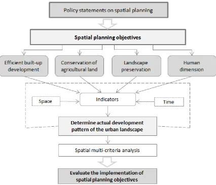
We propose a framework for evaluating the implementation of spatial planning objectives in the urban landscape (Figure 1). The framework has four dimensions — efficient built-up development, conservation of agricultural land, landscape preservation, and the human dimension — which reflect main domains of spatial planning. The dimensions were conceptualized based on the national spatial planning objectives of Switzerland and Romania (i.e., stated in the national legislation, as of December 2013), and represent common concerns of spatial planning. We limited their selection to include objectives that have direct impact on the spatial development patterns in urban areas, and could be spatially quantifiable (Table 1).
Preprints (www.preprints.org) | NOT PEER-REVIEWED | Posted: 30 May 2017 doi:10.20944/preprints201705.0207.v1
4 Figure 1. Framework for evaluating the implementation of spatial planning objectives
Following the recommendations of Wong and Watkins (2009), we made use of indicators capable of capturing both spatial patterns and dynamics over time to measure outcomes. For each dimension, we proposed a set of 2 - 4 indicators as recommended by Kienast, et al. [27] for landscape assessments (Table 2) and by Hersperger, Mueller, Knöpfel, Siegfried and Kienast [6] for evaluating planning outcomes. Indicators quantify changes between two moments in time and represent unique information at the grid/raster level.
5 Table 1. Dimensions for the assessment of the degree to which spatial planning objectives are reflected in the actual development pattern
1
Dimension Planning objectives as expressed in spatial planning
laws Category of indicators Indicator
A.
Efficient built-up development
Rational use of land, through controlled built-up development (RO a) and restricted land consumption
(CH a); orientation towards desired spatial
development (CH)
limit land uptake by built-up development
A1. built-up development rate due to private initiative
A2. built-up development rate due to public initiative
limit scattered built-up development
A3. changes in fragmentation of built-up areas
B.
Conservation of agricultural land
Protection of cultivable land (CH) and conservation of fertile agricultural land (RO)
reduce loss of agricultural land
B1. rate of loss of arable land B2. rate of loss of permanent crops
C. Landscape preservation
Preservation of landscape through maintaining public recreational areas (CH, RO); conservation of natural landscapes and recreational areas (CH)
Elimination of land-use conflicts (RO); appropriate location of homes and workplaces (CH); protection of residential areas against pollution (CH)
conserve natural landscapes and recreational areas
C1. forest area changes
C2. loss (gain) of public open space b
C3. loss (gain) of public green areas c
avoid land-use conflicts C4. changes in adjacencies between conflicting land uses d
D. Human dimension
Good accessibility of public and leisure facilities (RO, CH); ensure a good human habitat (RO); improve quality of life (RO)
improve communities’ quality of life
D1. changes in accessibility of nearest recreation areas
D2. changes in share of urban derelict land D3. changes in landscape diversity e
a The letters in brackets represent the country where the objective was adopted: CH - Switzerland; RO - Romania
2
b River banks and other small open spaces which are not considered urban parks
3
c Urban parks and public gardens
4
d Potentially conflicting land uses considered within the analysis: industrial - residential, derelict land - residential
5
eThe indicator was calculated as changes in the number of patches representing different land uses, within a 500 m radius
6
Preprints
(www.preprints.org) | NOT PEER-REVIEWED | Posted: 30 May 2017
doi:10.20944/preprints201705.0207.v1
Peer-reviewed version available at
6 The Efficient built-up developmentdimension addressessprawling built-up development in a direct 7
manner, as it has been identified as one of the pressing issues affecting the European urban landscape 8
[28-30]. The differentiation between built-up dynamic indicators (i.e., A1 and A2) was made in order to 9
draw attention to the driving forces behind landscape transformation. The two indicators highlight the 10
capacity of public and private actors to support urban development. Indicator A3. changes in
11
fragmentation of the built-up areas was introduced to evaluate the dispersed pattern of urban expansion. 12
The Conservation of agricultural land dimension is complementary to the expansion of built-up area. 13
The two indicators on agricultural land dynamics (i.e., B1 and B2) capture the way diversity of 14
agricultural activities is affected. Moreover, the two indicators can be used to assess which agricultural 15
land uses are more vulnerable to loss, as studies have pointed out that urban expansion affects them 16
differently [31]. 17
Landscape preservation dimension addresses the management of green and open spaces, and 18
potentially conflicting land uses. Urban forests and public green spaces are landscape features that 19
provide a wide range of urban ecosystem services, such as climate regulation, heat island reduction [32] 20
and the provision of leisure facilities for the local community [33]. Moreover, their protection is closely 21
related to the sustainability of cities [34]. In urban environments, the presence of open spaces indicates 22
the potential for nature-oriented recreation, and increases the perceived naturalness of the landscape 23
[35]. Management and avoidance of potentially conflicting land-use adjacencies are important aspects 24
of spatial planning [36]. Cities which experience a rapid increase in built-up areas are even more 25
exposed to the occurrence of conflicting situations [37]. 26
We considered it necessary to include the Human dimension because the way people use and 27
perceive urban landscapes should be an important component of spatial planning [38,39]. The role of 28
planning is to increase the quality of landscapes, including ordinary landscapes where communities 29
carry out their daily activities [40]. The D1 indicator refers to the availability of recreational areas. These 30
areas are connected to nature experiences [41,42], and provide a wide range of psychological and 31
physical health benefits. Indicators D2 and D3 indicators address landscape perception which is 32
evolutionarily determined [27,43], the two indicators being independent of cultural influences. Presence 33
of derelict land is perceived as being associated with desolation and a lack of activity [44], and 34
landscapes which are more diverse receive higher scores in landscape-preference ranking [45]. The D2 35
and D3 indicators were chosen because they express the preferences of both residents and experts. 36
3. Integration of the framework into a spatial multi-criteria analysis 37
In this section, we describe the integration of the developed framework (Figure 1) into a spatial 38
multi-criteria analysis. As decisions on how development should be performed may involve the 39
management of conflicting goals, multi-criteria analysis has proven to be a good method for exploring 40
and solving complex problems [20]. In multi-criteria analysis, a criterion expresses the degree of 41
achievement of an objective. Criteria are therefore measurable parameters, and their analysis can be 42
supported by resorting to indicators [46]. For urban areas, these indicators should measure the 43
functional and liveable dimensions of an area [47]. We assigned the criteria of the spatial multi-criteria 44
analysis as defined by the indicators of the framework (Table 1). 45
3.1.Criteria weights
46
To determine the weights of the criteria, we performed a pair wise comparison using Saaty’s [48] 47
nine point scale. To assign weights, we addressed the following question: given a pair of criteria, which 48
criterion has been identified in case studies as having more negative effects on efficient implementation 49
of spatial planning objectives? For example, when criteria A1. built-up development rate due to private
50
initiative and A2. built-up development rate due to public initiative were compared, a higher weight was 51
7 given to the A1 criterion, as studies [49,50] have shown that urban sprawl is mostly triggered by private 52
initiative. 53
We performed the pair wise comparison of the criteria within each dimension. We considered this 54
approach appropriate because the dimensions represent different aspects of spatial planning policy. The 55
sum of the weights was set to equal a value of 1 for each of the dimensions. 56
3.2.Calculation and standardization of indicators
57
Indicators were calculated as change rates between two moments in time. We used a 100 m × 100 58
m cell grid to calculate values, as this method has proven to be effective in avoiding redundancy in 59
spatial-based multi-criteria analysis [46]. Moreover, the cell size is reasonable when capturing urban 60
landscape characteristics. 61
As the selected indicators have different measurement scales and ranges, they cannot be compared 62
directly. A standardization to a dimensionless value is required. We used Mathematical Programming
63
[51] to transform the values to percentages. The worst values are set to equal 1 and the best values equal 64
to 100. The standardized values were calculated using the following formulas: 65
( ) =
∗
+
( ∗ – ) ( ∗ ),
66
(1)
67when the maximum expresses the worst value, and
68( ) =
∗
+
( ∗ ) ( ∗ ),
69
(2)
70when the minimum expresses the worst value. Zi represents the value of a criterion for cell i, max 71
represents the maximum value for the criterion, and min the minimum value for the same criterion [22]. 72
4. Testing the proposed framework 73
4.1. Selection of test areas and analysis period
74
We screened for potential study areas to test the proposed framework, by focusing on common 75
physical features. The common features of the case studies enable generalization [52] and allow for the 76
comparison of results. The following features were taken into consideration: relief, land use, 77
functionality of built-up areas, presence of public green areas and water bodies. Two cities – Zürich and 78
Bucharest – were chosen due to their relative importance at the national level, and high urbanization in 79
the past decade. An area of 33 km2 was chosen at the periphery of Bucharest, and an area of 42 km2 in
80
Zürich’s suburbs (Figure 2.). Boundaries of the study areas correspond to administrative borders and 81
water bodies. 82
Data on land cover/land use was obtained at the patch level by digitizing aerial images from Google 83
Earth, representing the years 2003 and 2012 for Zürich, and 2005 and 2013 for Bucharest. In addition, 84
we consulted urban plans and GIS information on land use provided by the Canton of Zürich [53] and 85
the Municipality of Bucharest [54],and conducted field visits. 86
Preprints (www.preprints.org) | NOT PEER-REVIEWED | Posted: 30 May 2017 doi:10.20944/preprints201705.0207.v1
8 87
Figure 2. Land cover of study areas in Switzerland (year 2012) and Romania (year 2013) 88
The analysis period was set so that it could be meaningful in terms of outcome evaluation. I was 89
necessary to take into account changes in spatial planning legislation, while maintaining similar 90
timeframes for the two countries. Baseline years (2003 – Switzerland, 2005 – Romania) were selected 91
based on planning legislation stability (i.e., no major planning legislation changes before or after the 92
selected years). Final years were chosen to be as close to the present as possible, and based on aerial 93
image availability. 94
4.2 Comparison of planning approaches in Romania and Switzerland
95
We compared Swiss and Romanian planning approaches in order to facilitate the understanding 96
of the results from the test areas. The comparison was conducted by analysing the legislation and 97
planning practices of the two countries. Although both countries have common objectives (as outlined 98
in the Table 2), information on how planning is performed could provide details regarding the reasons 99
behind the success or failure of the implementation. 100
5. Results 101
5.1 Results of the spatial multi-criteria analysis
102
Within the timeframes under study, built-up area developed due to private initiative increased 103
significantly in both study areas, whereas public built-up increased slightly in Switzerland and 104
decreased in Romania (Table 2). Fragmentation of built-up areas was rather similar in the two study 105
areas. Both study areas registered a reduction in agricultural land, notable being the dramatic loss of 106
arable land in Bucharest as agricultural activities were abandoned. There were no significant changes 107
in forest area, public open spaces or public green areas. However, there was a significant increase in 108
adjacencies between conflicting land uses in Romania. Accessibility of recreation areas, overall higher 109
in Switzerland, remained constant in both countries. Derelict land expanded significantly in Bucharest, 110
9 and overall the areas are much larger than in the Swiss case study. Landscape diversity decreased 111
slightly in Switzerland, but the amount of diversity is still higher than in Romania. Criteria weights 112
were assigned after a pair wise comparison, within each dimension. Higher weights were attributed to 113
criteria on fragmentation of built-up areas, changes in areas of permanent crops, and accessibility of 114
recreation areas (Table 2). 115
The average standardized scores show that there are not large discrepancies between the two study 116
areas (Table 3). However, the scores for each of the dimensions and their total value highlight that the 117
implementation of spatial planning objectives in Romania is less effective than in Switzerland (i.e., 118
indicated by the lower average scores). The higher standard deviation of standardized scores in 119
Romania also indicates the presence of areas with more extreme values (e.g., areas prone to experience 120
situations where actual development patterns are not in conformance with adopted objectives). 121
Partial score maps (Figures 3a and b) show, in a spatially explicit manner, the evaluation of the 122
implementation of spatial planning objectives. High scores (light colours) indicate a good fit between 123
policies and outcomes. The efficiency of built-up development wasevaluated based on Dimension A
124
scores. The results show that the Bucharest study area (Figure 3b) has was highly dynamic in terms of 125
built-up development. Compared to the Swiss study area (Figure 3a), development and fragmentation 126
rates were much higher. The conservation of agricultural land was affected in large compact areas in 127
Bucharest (Figure 3b) and small scattered areas in Zürich (Figure 3a), as indicated by the low scores in 128
Dimension B.Landscape preservation was under pressure in attractive areas nearby water bodies and 129
forests —in Bucharest (Figure 3 b), and in small and dispersed areas in the Swiss study area (Figure 130
3a)—as reflected by the distribution of Dimension C scores. The way in which people potentially use and 131
perceive the landscape is reflected in the scores of Dimension D. Although the study areas register both 132
high and low scores, the extent of lower scores is greater in Bucharest. Total scores reflect the overall 133
conformance with adopted spatial planning objectives. Compared to the Swiss study area—which 134
exhibits only values of greater than 30—values of less than 30, and a few cells with values of less than 135
20 were found in the Bucharest study area. In other words, these lower scores suggest that adopted 136
spatial planning objectives had less impact on actual urban area development in Romania. 137
Preprints (www.preprints.org) | NOT PEER-REVIEWED | Posted: 30 May 2017 doi:10.20944/preprints201705.0207.v1
10
Table 2.
Values of the corresponding indicators for each time step, and weight within the spatial multi-criteria analysis 138Analysed aspect Measurement
unit
Values for Corresponding
indicator/ criterion
Weight of the criterion
Switzerland Romania
2003 2012 2005 2013
built-up area due to private initiative m² 3901.548 5809.234 1690.427 4279.347 A1 0.218 built-up area due to public initiative m² 3096.057 3439.260 2758.007 2218.891 A2 0.091 fragmentation of built-up patches no. of edges 0.004 0.004 0.003 0.004 A3 0.691 area of arable land m² 2781.178 2686.142 2503.651 266.024 B1 0.355 area of permanent crops m² 87.328 83.922 687.418 434.389 B2 0.645
forest area m² 2009.594 2009.594 1935.586 1917.426 C1 0.323
area of public open spaces m² 298.839 288.008 61.059 59.538 C2 0.108 area of public green areas m² 0.000 0.000 147.078 147.078 C3 0.341 adjacencies between conflicting land uses meters 8.054 8.789 4.590 12.946 C4 0.228 accessibility of nearest recreation areas meters 190.126 190.126 290.505 290.405 D1 0.683 area of urban derelict land m² 64.174 35.369 712.648 2568.961 D2 0.200 landscape diversity no. of patches 13.139 12.676 9.333 10.366 D3 0.117 139
Table 3. Descriptive statistics of standardized scores per dimension 140
Switzerland Romania
Average score Standard deviation Average score Standard deviation
Dimension A 77.744 4.794 74.947 17.706
Dimension B 18.453 1.146 14.291 3.140
Dimension C 31.148 1.762 29.671 3.668
Dimension D 78.858 15.249 72.458 18.714
TOTAL 51.067 3.981 47.355 7.369
141
(www.preprints.org) | NOT PEER-REVIEWED | Posted: 30 May 2017
doi:10.20944/preprints201705.0207.v1
Peer-reviewed version available at
Sustainability
2017
,
9
, 1279;
11
a. b.
142
Figure 3. Partial scores for each dimension and total score for study area in a. Switzerland, and b. Romania. The lower the scores (and the lighter the colours), the 143
more development patterns are in conformance with planning objectives. Values can range between 0 and 100. 144
Preprints
(www.preprints.org) | NOT PEER-REVIEWED | Posted: 30 May 2017
doi:10.20944/preprints201705.0207.v1
Peer-reviewed version available at
Sustainability
2017
,
9
, 1279;
5.2 Planning strategies in Romania and Switzerland
Based on the Ahern’s [55] classification of planning strategies, we identify Romania as having a defensive planning strategy, as it seeks to react to the negative effects of spatial development. In contrast, Switzerland has a more protective planning strategy, since planning is used as an instrument to guide or orient development towards a desired spatial pattern. Through its legislative framework and planning practices, Romania promotes development while trying to control the negative outcomes of urban landscape change. The Romanian planning system attempts to arrest processes such as landscape fragmentation or urban sprawl, rather than to prevent them. A certain difference exists between what the legal framework’s aims are—in terms of landscape conservation, urban built-up containment, and preservation of recreational facilities and green areas—and how the legislation is enforced. In contrast, in Switzerland, space is considered a limited resource and its efficient management plays a central role in the planning system. Spatial planning aims to foresee urban dynamics and develop strategies to adapt to societal changes. Landscape preservation, urban sprawl prevention, and conservation of recreational areas are at the core of the planning system. If we could summarize each of the planning approaches in only two words, for Switzerland we would choose anticipate andprotect, whereas for Romania, develop and control.
6. Discussion
The present paper aims to contribute to the literature on the evaluation of planning outcomes. We developed a framework to evaluate the implementation of spatial planning objectives, with the use of spatially explicit information.
The framework and its integration into a spatial multi-criteria analysis allowed us to verify the conformance between adopted objectives and actual development patterns. Since most European countries have adopted similar spatial planning objectives [2], the framework can be used to extend between-states comparisons. Furthermore, the framework can be downscaled to within-state analyses (e.g., of cities or regions).
The indicators met the requirements identified by Opdam, Foppen and Vos [18], Wong and Watkins [5], and Wong [17] as being essential in outcome evaluation. They were able to capture landscape changes over time and space, and reflect both positive and negative aspects of these transformations. Since objectives are mostly expressed in terms of outcomes which are desired [17], the use of change indicators helped us overcome issues related to expressing only positive aspects. This way, indicators can be better used to track progress made, and signal issues regarding policy implementation [6].
The efficiency and utility of the framework was demonstrated by testing it in two study areas. The results provided valuable information that can be used to improve the performance of the planning process, such as locating where implementation of objectives is less effective, and domains of spatial planning which are affected. The use of the framework may increase planners’ accountability during the planning process, and strengthen public confidence in public institutions [56].
The scores of the spatial multi-criteria analysis showed that the implementation of spatial planning objectives is more convincing in Switzerland. Observed data can be explained by the protective planning strategy adopted in Switzerland. In contrast, the Romanian planning strategy encourages development, but the planning system is not very effective at controlling its negative impact. The dissimilarity between the planning approaches of the two countries has also been observed by Tudor, et al. [57], who point out that in Switzerland, land-use conflict resolution is more successful due to the focus on economic sustainability and equity among the actors involved, whereas in Romania conflict resolution is oriented towards landowner benefit, and planning regulations are poorly enforced. Particularly for Bucharest, our results are similar to those of Ianoş, Sorensen and Merciu [26] who note that land changes overrun the planning process.
In Switzerland, the efficient expansion of built-up areas and the conservation of agricultural land are considered priorities of the planning system [58], as space is a limited resource. The Romanian planning system is not mature enough [59] to enable efficient control of urban sprawl, and to avoid
2 of 18
2 fragmentation of agricultural land. Moreover, national policies sometimes contradict the objectives of spatial planning [60], as the need to encourage and support economic development could override other land management strategies.
The difference in scores on landscape preservation can be explained by the distinct approaches of Romania and Switzerland. Switzerland first adopted a law on landscape protection over 40 years ago [61], and has recently developed policy documents, such as Landscape 2020, to establish its landscape management vision [62]. Moreover, changes are monitored under the Swiss Landscape Monitoring Programme, as they are considered decisive in natural resource management and spatial planning [27]. In contrast, in Romania landscape protection is closely linked to the ratification of the Landscape Convention in 2002 and the designation of protected areas included in the Natura 2000 Network. Romania did not adopt policies that explicitly address landscape protection and management, and does not use landscape management plans.
The areas with low scores in the Human dimension in Bucharest are consistent with those identified by Grădinaru, Iojă, Onose, Gavrilidis, Pătru-Stupariu, Kienast and Hersperger [31] as being prone to experience land abandonment, and by Iojă, et al. [63] as having low accessibility to public green areas. In the Swiss study area, the low scores resulted mainly from the fact that recreation areas are located further away from the settlements. However, during the evaluation process, one should take into account that, in Switzerland, the network of trails and roads in agricultural areas are often used for recreational purposes [27].
For the evaluation procedure to be reliable and valid, certain aspects should be taken into consideration. Using spatially explicit indices to analyse landscape change patterns has proven useful, and their integration into a spatial multi-criteria analysis allowed us to evaluate conformance with desired outcomes. However, researchers and practitioners should be cautious in characterizing landscape functions, as a clear understanding of the relationship between the value of indicators and ecological processes is needed [64]. Planning evaluation should rely on additional measures of landscape performance, such as field observations and landscape perception surveys. Moreover, it should be taken into consideration that within this study, the criteria weights were subjectively assigned based on the authors` experience and knowledge. To improve this analysis step, further research could include the opinions of planning theoreticians and practitioners or the public.
7. Conclusions
We have shown that the developed framework is a powerful evaluation method. The results highlighted the framework’s ability to verify the conformance between spatial planning objectives and actual development patterns of the urban landscape. Due to the focus on spatial planning objectives—which are common to most European countries—the framework could easily be applied in both between-states, and between-cities outcome evaluations.
The results of the spatial multi-criteria analysis revealed a greater distance between objectives and outcomes for Romania, compared to Switzerland. These observations were attributed to the planning approaches of the two countries and to the different way they deal with landscape preservation and management.
Our study contributes to the current debate on the use of spatially explicit data for the purpose of verifying the degree of conformance between intentions and outcomes. As the volume and detail of available spatially explicit datasets is increasing, future research could focus on methodological advances for the integration of GIS and spatial information into the planning evaluation procedure, with a focus on various landscape scales and time series.
Acknowledgements: This work was supported by the Scientific Exchange Programme NMS-CH, Project number 13.263 “MUSELP – Modelling urban sprawl and its impact on landscape pattern”, the Swiss National Science Foundation ERC TBS Consolidator Grant BSCGIO 157789, and by a grant of the Romanian National
Preprints (www.preprints.org) | NOT PEER-REVIEWED | Posted: 30 May 2017 doi:10.20944/preprints201705.0207.v1
3 of 18
3 Authority for Scientific Research, PN-III-P4-ID-PCE-2016 -0635 - Nature-based solutions for increasing cities resilience and sustainability.
Author Contributions: Simona R Grădinaru, Cristian I. Iojă, Anna M. Hersperger conceived and designed the study; Simona R Grădinaru analysed the data and wrote the first draft of the paper; Anna M. Hersperger, Cristian I. Iojă and Ileana Stupariu offered guidance, support, and feedback for improving the paper.
Conflicts of Interest: The authors declare no conflict of interest.
References
1. Stead, D.; Nadin, V.M. Spatial planning: Key instrument for development and
effective governance with special reference to countries in transition. United Nations Economic Comission for Europe. Comittee on Housing and Land Management: Geneva, 2008.
2. Abrantes, P.; Fontes, I.; Gomes, E.; Rocha, J. Compliance of land cover changes with municipal land use planning: Evidence from the lisbon metropolitan region (1990– 2007). Land Use Policy 2016, 51, 120-134.
3. Alexander, E.R. Evaluating planning. What is successful planning and (how) can
we measure it? In Evaluation for participation and sustainability in planning, Hull, A.; Alexander, E.R.; Khakee, A.; Woltjer, J., Eds. Routledge: Abington, 2011; pp 32-46. 4. Faludi, A. The performance of spatial planning. Planning practice and Research 2000,
15, 299-318.
5. Wong, C.; Watkins, C. Conceptualising spatial planning outcomes: Towards an
integrative measurement framework. Town Planning Review 2009, 80, 481-516. 6. Hersperger, A.; Mueller, G.; Knöpfel, M.; Siegfried, A.; Kienast, F. Evaluating outcomes in planning: Indicators and reference values for swiss landscapes.
Ecological Indicators 2017, 77, 96-104.
7. Steiner, F. The living landscape. An ecological aproach to landscape planning. 2nd Edition
ed.; Island Press: 2008.
8. Guyadeen, D.; Seasons, M. Evaluation theory and practice comparing program
evaluation and evaluation in planning. Journal of Planning Education and Research
2016, 0739456X16675930.
9. Mueller, G.P.; Hersperger, A.M. Implementing comprehensive plans: Indicators for
a task-sheet based performance evaluation process. Journal of Environmental
Planning and Management 2015, 58, 2056-2081.
10. Carmona, M.; Sieh, L. Performance measurement in planning - towards a holistic view. Environment and Planning C: Government and Policy 2008, 26, 428-454.
11. Laurian, L.; Crawford, J.; Day, M.; Kouwenhoven, P.; Mason, G.; Ericksen, N.; Beattie, L. Evaluating the outcomes of plans: Theory, practice, and methodology.
Environment and Planning B 2010, 37, 740.
12. Talen, E. Do plans get implemented? A review of evaluation in planning. Journal of
planning literature 1996, 10, 248-259.
4 of 18
4
13. Lyles, W.; Stevens, M. Plan quality evaluation 1994–2012: Growth and
contributions, limitations, and new directions. Journal of Planning Education and
Research 2014, 34, 433-450.
14. Gennaio, M.-P.; Hersperger, A.M.; Bürgi, M. Containing urban sprawl - evaluating effectiveness of urban growth boundaries set by the swiss land use plan. Land Use
Policy 2009, 26, 224-232.
15. Long, Y.; Han, H.; Tu, Y.; Shu, X. Evaluating the effectiveness of urban growth boundaries using human mobility and activity records. Cities 2015, 46, 76-84. 16. Slaev, A.D.; Nedovic-Budic, Z. The challenges of implementing sustainable
development: The case of sofia’s master plan. Sustainability 2016, 9, 15.
17. Wong, C. Decision-making and problem-solving: Turning indicators into a
double-loop evaluation framework. In Evaluation for participation and sustainability in
planning, Hull, A.; Alexander, E.; Khakee, A.; Woltjer, J., Eds. Routledge: Abington,
2011; pp 14-31.
18. Opdam, P.; Foppen, R.; Vos, C. Bridging the gap between ecology and spatial planning in landscape ecology. Landscape Ecology 2001, 16, 767-779.
19. Malczewski, J. Gis-based multicriteria decision analysis: A survey of the literature.
International Journal of Geographical Information Science 2006, 20, 703-726.
20. Nijkamp, P.; Rietveld, P.; Voogd, H. Multicriteria evaluation in physical planning. Elsevier: 2013.
21. Kamruzzaman, M.; Baker, D. Will the application of spatial multi criteria
evaluation technique enhance the quality of decision-making to resolve boundary conflicts in the philippines? Land Use Policy 2013, 34, 11-26.
22. Iojă, C.I.; Niţă, M.R.; Vânău, G.O.; Onose, D.A.; Gavrilidis, A.A. Using multi-criteria analysis for the identification of spatial land-use conflicts in the bucharest metropolitan area. Ecological Indicators 2014, 42, 112-121.
23. Ianăși, L. Priorități pentru agenda legislativă în urbanism și amenajarea teritoriului. Editura Universitară Ion Mincu (in Romanian): București, 2008.
24. Marin, V.; Popescu-Criveanu, I. Audit al dezvoltării urbane în bucurești 1990-2010. Definirea unor direcții de dezvoltare din perspectiva medierii interesului public cu cel privat. Primaria Municipiului București (in Romanian): București, 2011.
25. Vinke-De Kruijf, J.; Augustijn, D.C.; Bressers, H.T. Evaluation of policy transfer interventions: Lessons from a dutch-romanian planning project. Journal of
Environmental Policy & Planning 2012, 14, 139-160.
26. Ianoş, I.; Sorensen, A.; Merciu, C. Incoherence of urban planning policy in bucharest: Its potential for land use conflict. Land Use Policy 2017, 60, 101-112. 27. Kienast, F.; Frick, J.; van Strien, M.J.; Hunziker, M. The swiss landscape monitoring
program - a comprehensive indicator set to measure landscape change. Ecological
Modelling 2015, 295, 136-150.
28. Couch, C.; Leontidou, L.; Petschel - Held, G. Urban sprawl in europe. Landscapes,
land-use change & policy. Blackwell Publishing: 2007.
Preprints (www.preprints.org) | NOT PEER-REVIEWED | Posted: 30 May 2017 doi:10.20944/preprints201705.0207.v1
5 of 18
5
29. EEA. Landscape fragmentation in europe. European Environment Agency:
Copenhagen, 2011.
30. Artmann, M. Institutional efficiency of urban soil sealing management – from raising awareness to better implementation of sustainable development in germany. Landscape and Urban Planning 2014, 131, 83-95.
31. Grădinaru, S.R.; Iojă, C.I.; Onose, D.A.; Gavrilidis, A.A.; Pătru-Stupariu, I.; Kienast, F.; Hersperger, A.M. Land abandonment as precursor of built-up development at the sprawling periphery of former socialist cities. Ecological Indicators 2015, 57, 305-313.
32. Gill, S.; Handley, J.; Ennos, A.; Pauleit, S. Adapting cities for climate change: The role of the green infrastructure. Built Environment (1978-) 2007, 115-133.
33. James, P.; Tzoulas, K.; Adams, M.D.; Barber, A.; Box, J.; Breuste, J.; Elmqvist, T.; Frith, M.; Gordon, C.; Greening, K.L., et al. Towards an integrated understanding of green space in the european built environment. Urban Forestry & Urban Greening
2009, 8, 65-75.
34. Chiesura, A. The role of urban parks for the sustainable city. Landscape and Urban
Planning 2004, 68, 129-138.
35. Walz, U. Monitoring of landscape change and functions in saxony (eastern germany) - methods and indicators. Ecological Indicators 2008, 8, 807-817.
36. Hersperger, A.M.; Iojă, C.I.; Tudor, A.C.; Steiner, F. Comprehensive consideration of conflicts in the land use planning process: A conceptual contribution. Carpathian
Journal of Earth and Environmental Sciences 2015, 10, 5-13.
37. Li, X.; Yeh, A.G.-O. Analyzing spatial restructuring of land use patterns in a fast growing region using remote sensing and gis. Landscape and Urban Planning 2004,
69, 335-354.
38. Ahern, J. Spatial concepts, planning strategies, and future scenarios: A framework method for intagrating landscape ecology and landscape planning. In Landscape
ecological analysis, Klopatek, J.M.; Gardner, R.H., Eds. Springer: 1999.
39. Kienast, F.; Degenhardt, B.; Weilenmann, B.; Wäger, Y.; Buchecker, M. Gis-assisted mapping of landscape suitability for nearby recreation. Landscape and Urban
Planning 2012, 105, 385-399.
40. CE. The european landscape convention. Council of Europe: 2000.
41. Kaplan, R.; Kaplan, S. The experience of nature: A psychological perspective. Cambridge University Press: Cambridge, NY, 1989.
42. Fan, P.; Xu, L.; Yue, W.; Chen, J. Accessibility of public urban green space in an urban periphery: The case of shanghai. Landscape and Urban Planning 2016. 43. Hunziker, M.; Buchecker, M.; Hartig, T. Space and place –two aspects of the
human-landscape relationship. In A changing world. Challenges for landscape research, Kienast, F.; Wildi, O.; Ghosh, S., Eds. Springer: 2007; pp 47-62.
6 of 18
6
44. Ruskule, A.; Nikodemus, O.; Kasparinskis, R.; Bell, S.; Urtane, I. The perception of abandoned farmland by local people and experts: Landscape value and
perspectives on future land use. Landscape and Urban Planning 2013, 115, 49-61. 45. Dramstad, W.E.; Tveit, M.S.; Fjellstad, W.; Fry, G.L. Relationships between visual
landscape preferences and map-based indicators of landscape structure. Landscape
and Urban Planning 2006, 78, 465-474.
46. Geneletti, D. An approach based on spatial multicriteria analysis to map the nature conservation value of agricultural land. Journal of Environmental Management 2007,
83, 228-235.
47. Sze, M.N.M.; Sovacool, B.K. Of fast lanes, flora, and foreign workers: Managing land use conflicts in singapore. Land Use Policy 2013, 30, 167-176.
48. Saaty, T.L. Multicriteria decision making. RWS Publ.: 1990.
49. Pojani, D. Urban and suburban retail development in albania`s capital after socialism. Land Use Policy 2011, 28, 836-845.
50. Sýkora, L.; Ourednek, M. Sprawling post-communist metropolis: Commercial and
residential suburbanization in prague and brno, the czech republic. In Employment
deconcentration in european metropolitan areas, Springer: 2007; pp 209-233.
51. Munier, N. Multicriteria environmental assessment: A practical guide. Springer Science & Business Media: 2004.
52. Stake, R.E.; Savolainen, R. The art of case study research. Sage publications Thousand Oaks, CA: 1995; Vol. 95004979.
53. Kanton Zürich. Das geografische informationssystem des kantons zürich.
Baudirektion: 2015.
54. Municipality of Bucharest. Urbonline. Www.Pmb.Ro. www.pmb.ro (June 2015),
55. Ahern, J. Theories, methods and strategies for sustainable landscape planning.
From landscape research to landscape planning. Aspects of integration, education and
application. Springer, Dordrecht, NL 2006, 119-131.
56. Kaiser, E.J.; Godschalk, D.R.; Chapin, S.F. Urban land use planning. University of Illinois Press: Urbana and Chicago, 1995.
57. Tudor, C.A.; Iojă, I.C.; Pǎtru-Stupariu, I.; Nită, M.R.; Hersperger, A.M. How successful is the resolution of land-use conflicts? A comparison of cases from switzerland and romania. Applied Geography 2014, 47, 125-136.
58. Nazarnia, N.; Schwick, C.; Jaeger, J.A. Accelerated urban sprawl in montreal, quebec city, and zurich: Investigating the differences using time series 1951–2011.
Ecological Indicators 2016, 60, 1229-1251.
59. ESPON. Governance of territorial and urban policies from eu to local level. Final report; INTERREG III ESPON Programme: 2006.
60. Munteanu, M.; Servillo, L. Romanian spatial planning system: Post-communist
dynamics of change and europeanization processes. European Planning Studies 2013,
22, 2248-2267.
Preprints (www.preprints.org) | NOT PEER-REVIEWED | Posted: 30 May 2017 doi:10.20944/preprints201705.0207.v1
7 of 18
7
61. Rudolf, S.C.; Grădinaru, S.R.; Hersperger, A.M. Impact of planning mandates on local plans: A multimethod assessment. European Planning Studies under review. 62. Niţă, A.; Buttler, A.; Rozylowicz, L.; Pătru-Stupariu, I. Perception and use of
landscape concepts in the procedure of environmental impact assessment: Case study - switzerland and romania. Land Use Policy 2015, 44, 145-152.
63. Iojă, C.I.; Grădinaru, S.R.; Onose, D.A.; Vânău, G.O.; Tudor, A.C. The potential of school green areas to improve urban green connectivity and multifunctionality.
Urban Forestry & Urban Greening 2014, 13, 704-713.
64. Corry, R.C.; Nassauer, J.I. Limitations of using landscape pattern indices to evaluate the ecological consequences of alternative plans and designs. Landscape
and Urban Planning 2005, 72, 265-280.