PIN 5101.53.121 US Route 219 Construction Section 5
Phase 3 Data Recovery Plan
Dorothy Scott 1 Site (NYSM 11338, UB 3640) Dorothy Scott 4 Site (NYSM 11341, UB 3643) Blackmar-Eaton (MDS 1001) Site (NYSM 11358, UB 3660)
Village of Springville and Town of Concord Erie County, New York.
By Ryan Austin, M.A. James Hartner, M.A., RPA
and
Douglas Perrelli, Ph. D., RPA
Douglas Perrelli, Ph.D., RPA Principal Investigator
Reports of the Archaeological Survey, Volume 37, Number 28 Department of Anthropology, State University of New York at Buffalo
October 2005
Prepared for
Ecology and Environment Inc. Lancaster, New York
TABLE OF CONTENTS
Page
Introduction 1
Site Identification 1
Site Location and Setting 1
Summary of Phase 1 Archaeological Reconnaissance Survey 6
Dorothy Scott 1 Site 6
Dorothy Scott 4 Site 8
Blackmar-Eaton (MDS 1001) Site 9
Summary of Phase 2 Site Examinations 12
Dorothy Scott 1 Site 12
Dorothy Scott 4 Site 17
Blackmar-Eaton (MDS 1001) Site 19
Site Descriptions 22
Dorothy Scott 1 Site 22
Dorothy Scott 4 Site 24
Blackmar-Eaton (MDS 1001) Site 25
Data Potential 32
Dorothy Scott 1 Site 32
Dorothy Scott 4 Site 34
Blackmar-Eaton (MDS 1001) Site 35
Research Objectives 36
Dorothy Scott 1 Site 36
Dorothy Scott 4 Site 38
Blackmar-Eaton (MDS 1001) Site 39
Research Topics 41
Dorothy Scott 1 and Dorothy Scott 4 Sites 41
Blackmar-Eaton (MDS 1001) Site 42
Field and Laboratory Methods 44
Dorothy Scott 1 Site 44
Dorothy Scott 4 Site 46
Blackmar-Eaton (MDS 1001) Site 47 Analysis Methods 48 Prehistoric 48 Historic 51 Curation Policy 55 Public Programs 56 Schedule 57 Fieldwork 57 Laboratory Processing 57 Analysis 57 Reporting 57
Human Remains Policy 58
List of Figures
Figure 1. General location of PIN 5101.53.121 Construction Section 5 in western New York. 2 Figure 2. PIN 5101.53.121 Construction Section 5: Locations of Phase 3 Sites shown on the 3 1954 Springville, New York and the 1979 photo-revised edition of the 1964 Ashford Hollow,
New YorkUSGS 7.5 Minute Series Quadrangles.
Figure 3. Dorothy Scott 1 Site (NYSM 11338, UB 3640): Results of Phase 1 surface inspection. 7 Figure 4. Dorothy Scott 4 Site (NYSM 11341, UB 3643): Site limits based on 8 results of Phase 1 fieldwork.
Figure 5. Blackmar-Eaton (MDS 1001) Site (NYSM 11358, UB 3660): Results of 10 Phase 1 surface inspection and shovel test pit grid.
Figure 6. Scott 1 site (NYSM 11338, UB 3640): Site limits based on results of Phase 1 and 2 fieldwork. 15 Figure 7. Scott 1 site (NYSM 11338, UB 3640): Phase 1 and 2 fieldwork in high density artifact area. 16 Figure 8. Limits of Scott 4 site (NYSM 11341, UB 3643) based on Phase 1 and 2 fieldwork. 18 Figure 9. Blackmar-Eaton (MDS 1001) Site (NYSM 11358, UB 3660): Phase 2 Site Limits 21 showing test unit and shovel test pit locations.
Figure 10. Blackmar-Eaton (MDS 1001) Site (NYSM 11358, UB 3660): First Occupation Period 27 Artifact Density Distribution (Blackmar, McKinney, & Darling Tenancies, c.1838-1857).
Figure 11. Blackmar-Eaton (MDS 1001) Site (NYSM 11358, UB 3660): Second Occupation Period 28 Artifact Density Distribution (Eaton & Oaks tenancies, c.1857-1900).
List of Tables
Table 1. Blackmar-Eaton (MDS 1001) Site (NYSM 11338, UB 3660) Phase 1 Artifact Summary. 11 Table 2. Scott 1 Site (NYSM 11338, UB 3640) Summary of Phase 2 13 Prehistoric Artifacts by Test Unit.
Table 3. Scott 1 site (NYSM 11338, UB 3640) Phase 2 Shovel Test Pit Artifact Summary. 13 Table 4. Scott 1 site (NYSM 11338, UB 3640) Phase 2 Surface Inspection Artifact Summary. 14 Table 5. Scott 4 site (NYSM 11341, UB 3643) Summary of Phase 2 Prehistoric Artifacts by Test Unit. 17 Table 6. Scott 4 site (NYSM 11341, UB 3643) Summary of Phase 2 Surface Artifacts. 18 Table 7. Scott 4 site (NYSM 11341, UB 3643) Summary of Phase 2 by Shovel test Pit. 18 Table 8. Blackmar-Eaton / MDS 1001 Site (NYSM 11358, UB 3660): Phase 2 Artifact Summary 20 Sorted by Functional Context.
Table 9. Blackmar-Eaton Site First Occupation Period Artifact Summary (c.1838 – 1857). 29 Table 10. Blackmar-Eaton Site Second Occupation Period Artifact Summary (c.1857 – 1900). 30 Table 11. Historic Artifact Functional Categorization System. 51 Table 12. Known Historic Records Describing the Blackmar-Eaton (MDS 1001) site. 53
List of Photos
Photo 1. Dorothy Scott 1 site (NYSM 11338, UB 3640), facing northwest at site’s location 4 on well drained knoll.
Photo 2. Dorothy Scott 4 site (NYSM 11341, UB 3643), facing southwest at the site’s location 4 on a low ridge.
Photo 3. Blackmar-Eaton (MDS 1001) site (NYSM 11358, UB 3660) during Phase 2 STP excavations, 5 facing north-northeast.
INTRODUCTION
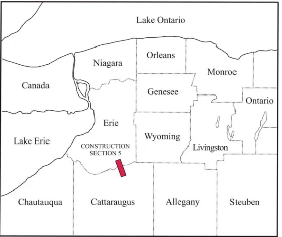
This document outlines a Phase 3 data recovery plan for three archaeological sites situated within the PIN 5101.53.121, Construction Section 5 project area limits. These include the prehistoric Dorothy Scott 1 (NYSM 11338, UB 3640) and Dorothy Scott 4 (NYSM 11341, UB 3643) sites and the historic Blackmar-Eaton (MDS 1001) site (NYSM 11358, UB 3660). All three sites are National Register eligible. They will be impacted by the federally funded construction of a 6.8 km (4.2 mi) segment of US Route 219; a divided four-lane highway with limited access. All the sites are located in the Town of Concord, Erie County, New York (MCD 02910).
The Phase 3 data recovery will be conducted under the US Route 219 programmatic agreement between the New York State Department of Transportation (NYSDOT), the Federal Highway Administration (FHWA), the New York State Office of Parks, Recreation and Historic Preservation (OPRHP), the National Advisory Council for Historic Preservation (NACHP) and the Seneca Nation of Indians (SNI). The Phase 3 study is designed to assure compliance with Section 106 of the National Historic Preservation Act of 1966 and complies with Title 36, Code of Federal Regulations, Part 61.
All aspects of this archaeological reconnaissance survey conform to the New York State Education Department's (SED) Work Scope Specifications for Cultural Resource Investigations (2004) and the New York Archaeological Council's (NYAC) Standards for Cultural Resource Investigations (1994). The Phase 3 investigations will be conducted by the Archaeological Survey, Department of Anthropology, University at Buffalo (SUNY Buffalo). The UB Archaeological Survey has been retained by Ecology and Environment Inc. (E&E), Lancaster, New York to conduct the Phase 3 archaeological investigations for Construction Section 5. Mr. Leonid Shmookler, Senior Archaeologist, E&E will work with the UB Archaeological Survey to develop appropriate testing strategies based on the results of the Phase 1 and 2 studies and will oversee all aspects of the Phase 3 investigations.
Other parties involved with the Phase 3 study include Mr. Thomas Donohue; Project Engineer, Parsons Transportation Group, Mr. Peter Nixon; High Priority Projects Group, NYSDOT Region 5 and Ms. Kathy Mitchell; Tribal Historic Preservation Office (THPO), Seneca Nation of Indians (SNI). The SNI will provide observers who will be present during the Phase 3 fieldwork.
Site Identification
The Dorothy Scott 1 and 4 sites, and the Blackmar-Eaton site, were first recorded by the archaeological reconnaissance survey conducted for PIN 5101.53.121 in 2002 (Hartner and Perrelli 2003). Subsequent Phase 2 site examinations completed in 2003 (Austin, Hartner and Perrelli 2004). Based on the results of these investigations, all three sites were all determined to be eligible for nomination to the National Register of Historic Places. Each site is eligible under Criterion D of the Secretary of the Interior's Standards and Guidelines for Archaeology and Historic Preservation (Federal Register 48[190], 1983). All have the potential to yield important information on either the prehistory or history of southwestern New York. Because the project plans can not be altered to avoid the three sites, a Phase 3 data recovery is proposed for each.
Site Locations and Setting
The three Phase 3 sites examined by this study are situated in southwestern New York state. The Construction Section 5 project area extends from southern Erie County into northern Cattaraugus County (Figure 1). The sites are all located near its northern end. Figure 2 shows their locations on the 1954 Springville, New York and the 1979 photo-revised edition of the 1964 Ashford Hollow, New York USGS 7.5 Minute Series Quadrangles. Detailed site maps and site photos are presented later in this report with the individual site descriptions. Photos 1-3 present views of each site’s setting at the time the Phase 2 fieldwork was conducted in 2003. They have remained unchanged and were still used as agricultural fields in the summer of 2005.
Photo 2. Dorothy Scott 4 site (NYSM 11341, UB 3643), facing southwest at the site’s location on a low ridge. Scott 1 site is located in the distance to left and the Scott 2-3 sites lie beyond the Scott 4 site to the right.
Photo 3. Blackmar-Eaton (MDS 1001) site (NYSM 11358, UB 3660) during Phase 2 STP excavations, facing north-northeast.
Summary of Phase 1 Archaeological Reconnaissance Survey
The three sites to be investigated by the Phase 3 data recovery projects were first recorded in 2002 during the Phase 1 archaeological reconnaissance survey for PIN 5101.53.121 (Hartner and Perrelli 2003). The Dorothy Scott 1 and 4 sites, and the Blackmar-Eaton site, were all identified as lying entirely within the Section 5 project limits. The Phase 1 work at each site is summarized below.
Dorothy Scott 1 Site (NYSM 11338, UB 3640). The Dorothy Scott 1 site is located in the Town of Concord, Erie County, New York (MCD 02910). The site lies about 600 m (1968 ft) south of NY Route 39 and 375 m (1230 ft) west of the existing alignment of US Route 219 (Figure 2). The Scott 1 site was identified during a surface inspection of a plowed field (Figure 3). This work indicated the site extended over a 65x100 m (213-328 ft) area, including a 20x40 m (65x131 ft) core area yielding about 75% of the artifact assemblage. The remaining site area represented a diffuse lithic scatter. Several outlying flakes were also recorded. Following the surface inspection, a 15 m (50 ft) shovel test pit grid was excavated encompassing the core artifact concentration and areas slightly beyond it. Two of these 56 STPs yielded a single flake each. Both finds were recovered at the outer edge of the STP grid, outside the artifact concentration recorded by the surface inspection.
Situated 180 m (590 ft) from a stream, the Scott 1 site lies in a landform classified by the NYSM background research as Stratum 5 (Hart 1998: Table 1). This stratum was assigned a high sensitivity given that it lies on a well drained upland ridge less than 250 m (820 ft) from a water source. The Scott 1 site lies at an elevation of 416-417 m (1364-1368 ft) above mean sea level on gently sloping terrain. West of the site, the topography becomes gently rolling as the ground surface begins to slope downwards. The headwaters of an unnamed tributary of Spooner Creek lie 125 m (410 ft) to the south; the ground surface gradually decreasing in elevation as the stream is approached. This stream flows southwest into Cattaraugus Creek about 1.8 km (1.1 mi) to the south. Cattaraugus Creek is the largest drainage in this part of western New York and drains much of the surrounding plateau as it travels westward to Lake Erie. Terrain to the north and east of the site is gently sloping and lacks prominent topographic features.
The Scott 1 site lies on deep, moderately well drained Castile gravelly loam soils (Owens et al. 1986: 38, Plate 127). This soil series is typically associated with elongated terraces, remnant beach ridges and undulating deltas. It has a high sand and gravel content. A broad area that bounds Cattaraugus Creek, including the Dorothy Scott 1 site, lies within the Chenango-Castile-Varysburg soil association (Owens et al. 1986). These soils form in glacial outwash deposits that tend to be well drained. Examination of the soil profiles of the 56 shovel test pits excavated in and around the site revealed two soil strata. The A-horizon plowzone is about 25-30 cm (12-14 in) thick. It is comprised of a dark grayish brown sandy or silty loam with numerous gravel inclusions. The upper part of the B-horizon subsoil is a dark yellowish brown silty sand or sandy silt with similar inclusions. Environmental conditions at the site are not appropriate for the formation of deeply buried archaeological deposits.
The Phase 1 results indicated the Scott 1 site is a low to moderate density lithic scatter. The prehistoric assemblage includes 61 artifacts. None was culturally or temporally diagnostic. Tools include an intact drill, a biface fragment, an end scraper and two utilized flakes. A large primary flake was also found. It is characterized as a suitable blank or chert piece for the manufacture of a formal tool. The remaining 55 finds consist of unmodified debitage. All are derived from Onondaga chert. Some of the debitage represents bifacial thinning flakes. Others are shatter or blocky fragments. The debitage includes two flakes with burnt, pot-lidded surfaces.
Indirect evidence of possible prehistoric feature(s) was observed in the form of two burnt flakes only. No other soil anomalies, charcoal fragments, fire-cracked rock or burnt soils were observed during the Phase 1 fieldwork. All the artifacts recovered at the Scott 1 site were found in plowzone soils.
Phase 1 investigations also recorded several small lithic scatters in the same plowed field as the Dorothy Scott 1 site. The Dorothy Scott 2-4 sites (UB 3641-3643) lie about 60-80 m (197-262 ft) to the west. Work there identified only a few artifacts at each location. A drill fragment found at the Dorothy Scott 4 site is similar to an intact example found at the Scott 1 site.
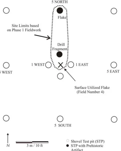
Dorothy Scott 4 Site (NYSM 11341, UB 3643). The Dorothy Scott 4 site is located in the Town of Concord, Erie County, New York (MCD 02910). It lies about 525 m (1722 ft) south of NY Route 39 and 560 m (1837 ft) west of the existing alignment of US Route 219 (Figure 2). The Phase 1 fieldwork first identified the Dorothy Scott 4 site during a surface inspection of a plowed field. This procedure recorded a flake findspot (FN 13). Twelve shovel test pits were subsequently excavated around this location at 1 and 5 meter (3.3 and 16 ft) intervals (Figure 4). Two STPs yielded additional artifacts consisting of a flake and a drill fragment. The Phase 1 results indicated the site encompassed a 5x5 m (16x16 ft) area. No testing subsurface testing was conducted beyond the 5 m (16 ft) STP grid.
Figure 4. Dorothy Scott 4 Site (NYSM 11341, UB 3643): Site limits based on results of Phase 1 fieldwork.
The Scott 4 site lies near a small stream in a landform classified by the background research as Stratum 5 (Hart 1998: Table 1). This stratum was assigned a high sensitivity given its well drained setting on an upland ridge less than 250 m (820 ft) from a water source. The site lies at an elevation of 415 m (1361 ft) above mean sea level. Environmental conditions are not appropriate for the formation of deeply buried deposits. Just west and south of the site, the surrounding topography becomes gently rolling as the ground surface begins a down slope trend. The headwaters of an unnamed tributary of Spooner Creek lie 210 m (689 ft) to the south. It flows southwestward into Cattaraugus Creek, which lies about 1.8 km (1.1 mi) to the south. It is the largest drainage in this part of western New York and drains much of the surrounding plateau into Lake Erie. Terrain north and east of the site is level to gently sloping and lacks prominent topographic features.
The site is situated on deep, moderately well drained Castile gravelly loam soils. This soil series is typically associated with elongated terraces, remnant beach ridges and undulating deltas. It has a high sand and gravel content. A broad area that bounds Cattaraugus Creek, including the Scott 4 site, lies within the Chenango-Castile-Varysburg soil association. These soils form in glacial outwash deposits that tend to be well drained. The soil profiles of 12 STP reveal two soil strata. The A-horizon plowzone is about 25-30 cm (10-12 in) thick. It is comprised of dark brown or brown sandy silt with numerous gravel inclusions. The upper B-horizon subsoil is yellowish brown with similar texture and inclusions.
The results of the Phase 1 study indicated that the Dorothy Scott 4 site represents a low density lithic scatter in close proximity to other small lithic scatters (Scott 1-3 sites). The prehistoric assemblage includes three artifacts. An unmodified flake was recovered on the ground surface (FN 13) and another was found in STP 49/5N. A drill fragment was found in STP 49/1N. All the artifacts are made of Onondaga chert. No evidence of prehistoric features was observed during the Phase 1 investigations. All three artifacts recovered by the Phase 1 study were found in plowzone soils.
Blackmar-Eaton (MDS 1001) Site (NYSM 11358, UB 3660). The Blackmar-Eaton (MDS 1001) site (UB 3660, NYSM 11358) was identified during the Phase 1 reconnaissance survey for PIN 5101.53.121, the proposed construction of US Route 219 section 5 (NYS Route 39 to Edies Road) in the Village of Springville and Town of Concord, Erie County, New York and the Towns of Ashford and Ellicottville, Cattaraugus County, New York (Hartner and Perrelli 2003).
The site is situated along the north side of Zoar Valley Road on the outskirts of the Village of Springville within Lot 68 B2 of Township 6, Range 7 of Joseph Ellicott’s 1797 survey of Holland Company Lands in Western New York. The project area lies within the Town of Concord, Erie County, New York, and encompasses the southern half of the small 2 acre lot. This property and all other properties will hereafter be referred to by a shortened version of the above property description (e.g. Lot 68 B2 [6/7]). The Phase 1B reconnaissance survey included the surface collection of a 55 x 80 m (180 x 262 ft) area according to a 5 m (16.4 ft) inspection grid. Phase 1 testing also included the excavation of 40 shovel test pits (STPs 672.1 to 672. 40) along a 15 m (50 ft) grid overlying the surface inspection area. A graphical representation of site and project area limits showing the location of surface inspection cells and STP locations is presented in Figure 5.
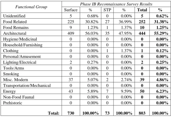
A total of 803 historic artifacts were recovered from the Blackmar-Eaton (MDS 1001) site during the Phase 1B survey, including 730 artifacts from the surface collection and 73 artifacts from 19 shovel test pits. Sorted according functional category, the assemblage includes a total of 5 (0.62%) unidentified artifacts, including examples of burnt glass ceramics, as well oxidized metal artifacts; 252 (31.38%) food related artifacts, including ceramic and glass tableware, glass bottles and metal can container fragments.; 10 (1.25%) food remains eco-facts, including mammal bone and shell; 444 (55.29%) architectural artifacts, including brick, cut and wire nails, mortar and flat glass; 1 (0.12%) clothing group artifact, a leather fragment; 2 (0.25%) lighting / electrical artifacts, both identified as ceramic electrical insulators; 39 (4.86%) miscellaneous modern artifacts, consisting of plastic objects; and 50 (6.23%) energy group artifacts, including coal, charcoal, coal ash, and slag. A tabular summary of the functional categorization of the Phase 1 artifacts is presented below in Table 1.
The 5 m (16 ft) surface inspection grid data revealed that the high density portion of the scatter encompasses about a 25 x 30 m (83 x 100 ft) area within the project limits. It lies just east of the western edge of the small lot line indicated on the historic maps. Relatively few finds occurred west of the lot line. Slightly greater numbers of finds occurred north of the artifact concentration. Whether this represents debris disposal patterns, the effects of plowing on site micro-stratigraphy could not be determined. The shovel test pit data indicates that a low density scatter extends slightly beyond the boundaries of the surface inspected area to encompass an area of about 75 x 90 m (246 x 295 ft). Few artifacts were found in environs outside of main artifact concentration (Hartner and Perrelli 2003:205).
Figure 5. Blackmar-Eaton (MDS 1001) Site (NYSM 11358, UB 3660), Results of Phase 1 surface inspection and shovel test pit grid.
Table 1. Blackmar-Eaton (MDS 1001) Site (NYSM 11338, UB 3660) Phase 1 Artifact Summary.
Phase IB Reconnaissance Survey Results Functional Group Surface % STP % Total % Unidentified 5 0.68% 0 0.00% 5 0.62% Food Related 225 30.82% 27 36.99% 252 31.38% Food Remains 9 1.23% 1 1.37% 10 1.25% Architectural 409 56.03% 35 47.95% 444 55.29% Hygiene/Medicinal 0 0.00% 0 0.00% 0 0.00% Household/Furnishing 0 0.00% 0 0.00% 0 0.00% Clothing 0 0.00% 1 1.37% 1 0.12% Personal/Amusement 0 0.00% 0 0.00% 0 0.00% Lighting/Electrical 2 0.27% 0 0.00% 2 0.25% Tools/Arms 0 0.00% 0 0.00% 0 0.00% Smoking 0 0.00% 0 0.00% 0 0.00% Misc. Modern 37 5.07% 2 2.74% 39 4.86% Transportation/Mechanical 0 0.00% 0 0.00% 0 0.00% Energy 43 5.89% 7 9.59% 50 6.23% Non-Food Faunal 0 0.00% 0 0.00% 0 0.00% Prehistoric 0 0.00% 0 0.00% 0 0.00% Total: 730 100.00% 73 100.00% 803 100.00%
Possible evidence of a historic feature was located during the Phase 1 investigations. The soil profile of STP 672.17 displayed deep organic soils along the south wall of the excavation. It contrasted sharply with the yellowish brown subsoil. This anomaly began just below the plowzone soils and extended to the bottom of the shovel test pit at 71 cm (28 in) below the ground surface. Two modern brown bottle glass shards, two U-staples and four brick fragments were found in the stain. This shovel test pit lies near the high-density portion of the artifact scatter, near the lot line dividing the small house lot MDS 1001 was once located on from the adjacent corn field to the west. STP 672.17 also lies just a few meters north of Zoar Valley Road. The limited evidence presented in this single STP precluded its direct association with the nineteenth to early twentieth century domestic occupation of MDS 1001. It is possible that the ‘feature’ could also be related to a later twentieth disturbance resulting from utility line excavation or road construction.
Except for the soil anomaly observed in STP 672.17, all the artifacts recovered by the Phase 1 study were found on the ground surface or in plow-zone soils. This soil stratum is between 25 and 35 cm (10 and 14 in) deep based on shovel test pit soil profiles. Artifacts were found throughout this soil stratum. The limited subsurface testing completed as part of the Phase 1 investigations is considered a preliminary examination of the site. Additional work is required to determine the extent, if any, of intact deposits within the subsoil. Such deposits could potentially occur in a cellar hole, well or a midden pit associated with domestic and agricultural activities that occurred during the site’s the nineteenth and early twentieth century domestic occupation.
Summary of Phase 2 Site Examinations
Fieldwork for the Phase 2 site examinations for PIN 5101.53.121 were conducted by the SUNY Buffalo Archaeological Survey in the summer of 2003. This study examined 12 prehistoric sites and one historic site. Based on the results of this work, Phase 3 investigations were recommended for the Dorothy Scott 1, Dorothy Scott 4 and Blackmar-Eaton (MDS 1001) sites.
Dorothy Scott 1 Site (NYSM 11338, UB 3640). A Phase 2 site examination was recommended because the Scott 1 site represents a small, upland site in a region where few such sites have been previously recorded or systematically investigated. It offers an opportunity to study its role in regional and local settlement patterns and to further the understanding of the use of prehistoric lithic technology in this environmental niche. Increased knowledge of the site will provide insights into the subsistence strategies of its occupants and help determine its relationship, if any, with the nearby Dorothy Scott 2-4 sites.
The primary goal of the Phase 2 site examination of the Scott 1 site was to gather sufficient data to determine the site’s National Register eligibility. The investigations assessed the integrity and extent of prehistoric archaeological deposits within project limits. Research objectives included refining the horizontal and vertical limits of the site, documenting soil stratigraphy, identifying buried cultural features, and determining whether the site possesses sufficient integrity and research potential. Examination of the site could potentially reveal important information about logistical camps, base camps or habitation sites along Cattaraugus Creek and could yield data on site type, size, landscape utilization and resource exploitation for one or more periods of prehistory. Pit and hearth features, if present, will offer insights into resource utilization, subsistence and dietary practices, and specific types of activities that occurred at this location. Based on data recovery and research potential, a Phase 2 site examination was proposed for the prehistoric component(s) of the site to determine National Register eligibility.
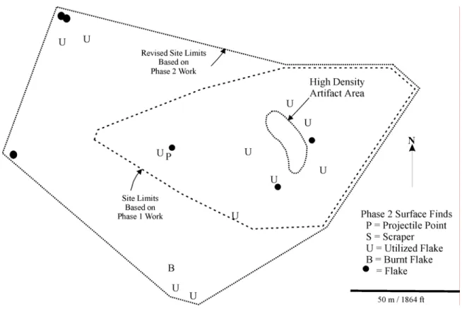
Given the plowed field setting of the Scott 1 site, the Phase 2 investigations began with a surface inspection (Figures 6-7). This work complimented previous Phase 1 surface inspection. The site was inspected for a minimum distance of at least 30 m (100 ft) beyond the Phase 1 site limits. The Phase 2 artifact locations were recorded using the relocated Phase 1 site datum and baseline.
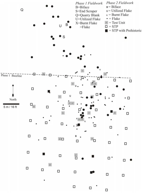
The subsurface testing included both shovel test pits (STPs) and test unit excavations (TUs). Work began with a series of 52 shovel test pits excavated at a five meter (16 ft) interval. These complimented the Phase 1 STP grid. The Phase 2 shovel test pit grid was followed by a series of test unit excavations to further define the horizontal and vertical limits of the site and assess its integrity. Phase 2 investigations included 17 block excavations with most measuring 1x1 m (3.3x3.3 ft) in area. A few were slightly larger. Most were placed in and around the high-density core of the surface scatter. Several were located in low-density areas.
Phase 2 excavations recovered 620 lithic artifacts (Tables 1-3). No ceramics or other non-chert artifacts were found. The site yielded a diverse formal tool assemblage, including a projectile point fragment, four bifaces, seven flake tools, 36 utilized flakes and 572 unmodified flakes. Many stages of a formal, bifacial tool manufacturing sequence are represented ranging from a pre-form or quarry blank that shows minimal preparation of raw chert to nondescript late stage bifaces. The presence of debitage indicates a bifacial reduction sequence took place at the site either for the manufacture of stone tools, the maintenance of an existing tool kit or perhaps both.
Finds include 58 burnt artifacts suggesting the presence of hearth features or other areas where burning occurred throughout the site. One pit feature was identified by the Phase 2 excavations. Feature 5 yielded a radiocarbon date from feature in the undisturbed B-horizon subsoil of TU 31. The core of the feature was floated resulting in the recovery of numerous small flakes and charred material, mostly wood charcoal. This sample yielded a conventional radiocarbon age of 2480 +/- 40 BP that firmly dates the charred material to the Meadowood Phase of the Early Woodland period based. The Phase 2 work also recovered the medial section of a projectile point probably dating to the Meadowood Phase.
Table 2. Dorothy Scott 1 Site (NYSM 11338, UB 3640) Summary of Phase 2 Prehistoric Artifacts by Test Unit. TU# Projectile Point Biface Utilized Flake Burnt Flake
Core Debitage Other FCR Total
10 - - 2* - - 20 - - 22 11 - - - 1 - 12 - - 13 12 - - 1 1 - 12 - - 14 13 - - 1 1 - 13 - - 15 14 - - - - - 1 - - 1 15 - - 1 - - 3 - - 4 16 - - 1 2 - 23 - - 26 17 - - - - - 19 - - 19 18 - - - - - 1 - - 1 19 - - - 1 - 19 - - 20 20 - - - - - 12 - - 12 21 - - - - - 5 - - 5 22 - - - - - 3 - - 3 23 - - - - - 1 - - 1 24 - - - - - - - - 0 25 - - 3* 1 - 47 - - 51 26 - - - - - 17 - - 17 27 - - 1 3 - 40 - - 44 28 - - - - - 6 - - 6 29 - 1 8* 35 - 145 - - 189 31 - 1 2* 3 - 54 - - 60 32 - - - - - - - - 0 34 - - - - - - - - 0 Total 0 2 20 48 0 452 0 0 522 FCR = Fire-cracked rock
• = utilized flakes identified as part of detailed lithic analysis
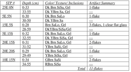
Table 3. Dorothy Scott 1 site (NYSM 11338, UB 3640) Phase 2 Shovel Test Pit Artifact Summary.
STP # Depth (cm) Color/ Texture/ Inclusions Artifact Summary
25E 0N 0-33 Dk Brn SiSa, Grl 1-flake
33-55 Dk YBrn Sa, Grl ---
5E 5N 0-30 Dk Brn SaLo 1-flake
30-50 Dk YBrn Sa ---
15E 5S 0-28 Brn SaLo, Grl 3-flakes, 1-clear flat glass 28-59 DkYBrn/SiSa/Grl ---
5E 15S 0-32 Dk Brn SaLo, Grl 1-flake
32-55 Dk YBrn SiSa, Grl ---
20E 15S 0-31 Dk Brn SaLo, Grl 2-flakes
31-52 YBrn SaSi, Grl ---
20E 20S 0-29 Dk Brn SaLo, Grl 1-flake
29-49 YBrn SiSa, Grl ---
10E 15N 0-34 GBrn SaSi 2-flakes
34-55 RBrn SiSa ---
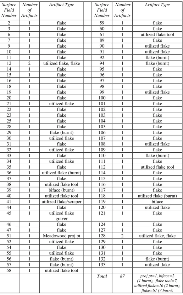
Table 4. Scott 1 site (NYSM 11338, UB 3640) Phase 2 Surface Inspection Artifact Summary. Surface Field Number Number of Artifacts
Artifact Type Surface Field Number Number of Artifacts Artifact Type 2 1 flake 59 1 flake 3 1 flake 60 1 flake
6 1 flake 61 1 utilized flake tool
7 1 flake 89 1 flake
9 1 flake 90 1 utilized flake
10 1 flake 91 1 utilized flake
11 1 flake 92 1 flake (burnt)
12 2 utilized flake, flake 94 1 flake (burnt)
14 1 flake 95 1 flake
15 1 flake 96 1 flake
16 1 flake 97 1 flake
18 1 flake 98 1 flake
19 1 flake 99 1 utilized flake
20 1 flake 100 1 flake
21 1 utilized flake 101 1 flake
22 1 flake 102 1 flake
23 1 flake 103 1 flake
25 1 flake 104 1 flake
28 1 flake 105 1 flake
29 1 flake (burnt) 106 1 flake
30 1 utilized flake 107 1 flake
31 1 flake 108 1 utilized flake
32 1 utilized flake 109 1 flake
33 1 flake 110 1 flake (burnt)
34 1 utilized flake 111 1 flake
35 1 flake 112 1 utilized flake tool
36 1 utilized flake (burnt) 114 1 flake
37 1 flake 115 1 flake
38 1 utilized flake tool 116 1 flake
39 1 biface (burnt) 117 1 flake
40 1 utilized flake tool 118 1 utilized flake (burnt)
41 1 utilized flake/scraper 119 1 biface
44 1 flake 120 1 utilized flake
45 1 utilized flake
graver
121 1 flake
46 1 flake 124 1 flake
47 1 flake 127 1 flake
51 1 Meadowood proj pt 128 2 utilized flake, flake
52 1 utilized flake 129 1 flake
54 1 flake 130 1 flake
55 1 utilized flake 131 1 flake
56 1 flake (burnt) 132 1 flake (burnt)
57 1 flake (burnt) 133 1 utilized flake
58 1 utilized flake tool
Total 87 proj pt=1, biface=2 (1 burnt), flake tool=7, utilized flake=16 (2 burnt),
Dorothy Scott 4 Site (NYSM 11341, UB 3643). A Phase 2 site examination was recommended because the Scott 4 site represents a small, upland site in a region where few such sites have been previously recorded or systematically investigated. It offers an opportunity to study its role in regional and local settlement patterns and to further the understanding the use of prehistoric lithic technology in this environmental niche. Increased knowledge of the site will provide insights into the subsistence strategies of its occupants and help determine its relationship, if any, with the nearby Dorothy Scott 1-3 sites.
The primary goal of the Phase 2 site examination of the Scott 1 site was to gather sufficient data to determine the site’s National Register eligibility. The investigations assessed the integrity and extent of prehistoric archaeological deposits within project limits. Research objectives included refining the horizontal and vertical limits of the site, documenting soil stratigraphy, identifying buried cultural features, and determining whether the site possesses sufficient integrity and research potential. Examination of the site could potentially reveal important information about logistical camps, base camps or habitation sites along Cattaraugus Creek and could yield data on site type, size, landscape utilization and resource exploitation for one or more periods of prehistory. Pit and hearth features, if present, will offer insights into resource utilization, subsistence and dietary practices, and specific types of activities that occurred at this location. Based on data recovery and research potential, a Phase 2 site examination was proposed for the prehistoric component(s) of the site to determine National Register eligibility.
Given the plowed field setting of the Scott 1 site, the Phase 2 investigations began with a surface inspection (Figures 8). This work complimented previous Phase 1 surface inspection. The site was inspected for a minimum distance of at least 30 m (100 ft) beyond the Phase 1 site limits. The Phase 2 artifact locations were recorded using the relocated Phase 1 site datum.
The subsurface testing included both shovel test pits (STPs) and test unit excavations (TUs). Work began with a series of 16 shovel test pits excavated at a five meter (16 ft) interval. These extended the Phase 1 STP grid. An outlying Phase 2 surface find was examined at 1-5 m (3.3-16 ft) intervals. The Phase 2 shovel test pit grid was followed by a series of test unit excavations to further define the horizontal and vertical limits of the site and assess its integrity. Phase 2 investigations included four 1x1 m (3.3x3.3 ft) excavations.
Phase 2 excavations recovered 20 lithic artifacts (Tables 4-6). No ceramics or other non-chert artifacts were found. Despite its small size, the site yielded a diverse tool assemblage, including a projectile point fragment, a biface and three utilized flakes. The remaining 15 finds represent unmodified flakes. The ratio of tools to debitage suggests a variety of tasks were occurring there, but that formal, bifacial tool reduction was not one of them. The debitage would appear to represent the manufacture of expedient flake tools or the maintenance of an existing tool kit, perhaps both.
The Phase 2 surface inspection that resulted in the recovery of three additional flakes in the same general area as the Phase 1 finds. The shovel test pit grid yielded one additional flake. Test unit excavations were then placed in the artifact concentration identified by the Phase 1 and 2 finds. This work yielded the remaining part of the Phase 2 assemblage, including the projectile point. The only temporally diagnostic artifact was recovered from the site. This a relatively small Vosburg projectile point dating to the Late Archaic period (circa 4200-4800 BP).
Table 5. Scott 4 site (NYSM 11341, UB 3643) Summary of Phase 2 Prehistoric Artifacts by Test Unit.
TU# Projectile Point Biface Utilized Flake Burnt Flake
Core Debitage Other FCR Total
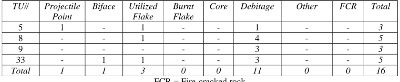
5 1 - 1 - - 1 - - 3 8 - - 1 - - 4 - - 5 9 - - - - - 3 - - 3 33 - 1 1 - - 3 - - 5 Total 1 1 3 0 0 11 0 0 16 FCR = Fire-cracked rock
Table 6. Scott 4 site (NYSM 11341, UB 3643) Summary of Phase 2 Surface Artifacts.
Surface Field Number Artifact Type
65 flake 66 flake 67 flake
Total flake=3
Table 7. Scott 4 site (NYSM 11341, UB 3643) Summary of Phase 2 by Shovel test Pit. STP # Depth (cm) Color/ Texture/ Inclusions Artifact Summary
FN 66 / 5E 0-28 Brn SiSa, Grl 1-flake 28-47 Dk YBrn Sa, Grl ---
Total 1-flake
Blackmar-Eaton (MDS 1001) Site (NYSM 11358, UB 3660). The Blackmar-Eaton (MDS 1001) site encompasses a two acre parcel located the northeastern corner of Lot 68B of Township 6, Range 7 of the original Holland Land Survey Area, within the present-day Town of Concord (MCD 02910), Erie County, New York and the Village of Springville (MCD 02957). The Phase 2 site limits were defined during the Phase 1 archaeological reconnaissance survey conducted in 2002 by the Archaeological Survey of the State University of New York at Buffalo (Hartner and Perrelli 2003:204-207).
A Phase 2 site examination was recommended because the Blackmar-Eaton (MDS 1001) site represents a small nineteenth and early twentieth century tenant farmstead in a region where few such sites have been previously recorded and/or systematically investigated. The results of the Phase 1 study indicated that the site offered evidence for changes in material culture acquisition, use and deposition by historically documented site occupants throughout the course of the nineteenth and early twentieth centuries. During this period, improvements made to transportation, infrastructure, market access and manufacturing facilitated the development of a rural agricultural economy characterized by an ever increasing reliance on regional commerce and mass produced consumer products. Not only would further excavation of the site examine how the daily lives of site occupants were affected by their participation in the local and regional economy, but how their own personal identities and histories impacted the site development.
The MDS 1001 site lies entirely within the Construction Section 5 project area and will be impacted by the proposed US Route 219 Freeway Alternate. The research potential of the site is enhanced because the entire domestic portion of the former tenant farmstead is located within the project limits. This will allow for relationships between the MDS 1001 location and artifact concentrations, features, outbuildings and the like to be studied in detail. Further investigation of these deposits is likely to yield important information on the history of southwestern New York. Therefore, a Phase 2 site examination was recommended in order to ascertain the site’s eligibility for nomination to the National Register under Criteria D.
The archaeological sampling strategy included a combination of surface inspection, shovel testing and test unit excavation within the Lot 68B2 site property, as well as in the adjacent field to the west. While concentrated within the site property, archaeological testing was conducted within the adjacent field in order to further define the western site limits. The Phase 2 site measures 48 m (157.48 ft) east-west (SW-NE) along Zoar Valley Road by 77 m (252.62 ft) North – South, a total area of 3,696 sq. meters (12,125.98 sq. ft), and is confined to the southern half of Lot 68 B2 (6/7). A Phase 2 site map is presented below in Figure 9 depicting project area limits, site limits and archaeological testing locations.
One hundred and seventy-seven 5 sq. m (16.5 sq. ft) surface inspection cells were collected across both historic properties, a total area of 855 sq. m (2,821.5 sq. ft). One hundred and forty-nine 50 sq. cm(1.64 sq. ft) shovel test pits were excavated along eleven transects; a total area of 74.5 sq. meters (244.4 sq. ft). The STPs were excavated according to natural soil levels. Finally, 10 test units, a total area of 10 sq. m (32.8 sq. ft) were excavated with Lot 68 B2. The TUs were positioned in areas that were determined to possess high concentrations of artifacts, intact features and intact historic fill and subsoil strata during surface inspection and shovel testing. TU soils were excavated in arbitrary 10 cm (ft) levels in order to record intra-level depositional patterns. Finally, all site soils examined by STP and TU excavation were sifted through 6 mm (1/4 in) wire mesh screens in order to maximize artifact recovery.
A total of 8,790 artifacts were recovered during the Phase 2 Site Examination, including 3,109 artifacts from test unit excavation, 2,842 artifacts from shovel testing and 2,839 from surface inspection (Table 8). Sorted according to function, the Phase 2 site assemblage includes 200 (2.28%) unidentified artifacts; 1,547 (17.60%) food related artifacts; 88 (1.00%) food remains eco-facts; 6,042 (68.74%) architectural objects; 1 (0.01%) household/furnishing artifact (a mirror fragment); 8 (0.09%) clothing related items, 5 (0.06%) personal/amusement artifacts; 2 (0.02%) lighting/electrical artifacts; 5 (0.06%) tools/arms related objects; 16 (0.18%) smoking group items; 172 (1.96%) miscellaneous modern artifacts (plastic); 78 (0.89%) transportation/mechanical related objects; 530 (6.03%) energy group items (coal, coal ash, slag, charcoal); and 96 (1.09%) non-food faunal skeletal elements.
Table 8. Blackmar-Eaton / MDS 1001 Site (NYSM 11358, UB 3660): Phase 2 Artifact Summary Sorted by Functional Context.
Phase 2 Site Examination Functional Group TU % STP % Surface % Ph II % Unidentified 112 3.60% 69 2.43% 19 0.67% 200 2.28% Food Related 502 16.15% 552 19.42% 493 17.37% 1,547 17.60% Food Remains 75 2.41% 0 0.00% 13 0.46% 88 1.00% Architectural 2,082 66.97% 1,944 68.40% 2,016 71.01% 6,042 68.74% Hygiene/Medicinal 0 0.00% 0 0.00% 0 0.00% 0 0.00% Household/Furnishing 0 0.00% 1 0.04% 0 0.00% 1 0.01% Clothing 1 0.03% 4 0.14% 3 0.11% 8 0.09% Personal/Amusement 4 0.13% 0 0.00% 1 0.04% 5 0.06% Lighting/Electrical 0 0.00% 0 0.00% 2 0.07% 2 0.02% Tools/Arms 1 0.03% 2 0.07% 2 0.07% 5 0.06% Smoking 9 0.29% 3 0.11% 4 0.14% 16 0.18% Misc. Modern 9 0.29% 35 1.23% 128 4.51% 172 1.96% Transportation/Mechanical 0 0.00% 10 0.35% 68 2.40% 78 0.89% Energy 253 8.14% 187 6.58% 90 3.17% 530 6.03% Non-Food Faunal 61 1.96% 35 1.23% 0 0.00% 96 1.09% Prehistoric 0 0.00% 0 0.00% 0 0.00% 0 0.00% Total: 3,109 100.00% 2,842 100.00% 2,839 100.00% 8,790 100.00%
Artifacts were unevenly distributed horizontally throughout the project area. A high density artifact concentration was observed within the site’s southwest quadrant, in the area located between the western boundary line of Lot 68B2 (6/7) and Zoar Valley Road. Though a dense concentration in this area was noted in AP-, B21-,
B22- and B23-Horizon soils, the majority of associated artifacts were recovered from the plough-zone, and to a lesser extent, B21-Horizon subsoil and historic fill soils. Furthermore, all artifacts identified in B21-, B22- and B23-Horizon soils and in second strata fill soils were found in the Blackmar-Eaton site’s southwest corner.
In addition, six (6) historic features were also recovered during the Phase 2 Site Examination. Features 1, 2, 4 and 5 were identified as posthole/post-molds. Identified as postholes, Features 1 and 2 were located near the site’ Zoar Valley Road frontage in TU 5, at the transition between Ap- and B21-Horizon soils. Nine (9) artifacts were recovered from Feature 1, while only a single (1) artifact was recovered from Feature 2, all of which were identified as charcoal. Features 4 and 5 were located along the site’s western property line, within TU 6. Both features, also identified as postholes, were found at the transition between B21- and B22-Horizon soils. Both of these features were positioned just outside of Feature 3, a deeply buried pit midden/privy feature. It is yet not clear how Features 3, 4 and 5 are related, though it is possible that the former posts were part of a small outbuilding associated with the pit. Feature 6 was the only historic feature located outside of the high density scatter, in the northwestern corner of the project area, and was identified as the fully articulated skeleton of a juvenile pig (Sus scrofa). No evidence of butchery or gnaw marks were observed, suggesting that the animal may have been diseased, killed by dogs, or intentionally buried as a pet.
Figure 9. Blackmar-Eaton (MDS 1001) Site (NYSM 11358, UB 3660): Phase 2 Site Limits showing test unit and shovel test pit locations
Site Descriptions
Individual site descriptions are presented below for the three sites where Phase 3 work is proposed: the prehistoric Dorothy Scott 1 (NYSM 11338, UB 3640) and Dorothy Scott 4 (NYSM 11341, UB 3643) sites, and the historic Blackmar-Eaton (MDS 1001) site (NYSM 11358, UB 3660). The site descriptions are based on the results of the Phase 1 and 2 excavations.
Dorothy Scott 1 Site (NYSM 11338, UB 3640)
Context. Temporally diagnostic evidence associated with the Scott 1 site indicates it represents a Meadowood Phase occupation dating to the Early Woodland period (circa 2300-2900 BP). The results of the Phase 2 site examination indicate the Scott 1 site has provided important information about the prehistoric occupation of the Cattaraugus Creek valley and the Allegheny Plateau during this period. Sites of this age are more numerous on parts of the Erie lake plain region of western New York and relatively few have been recorded in upland settings. The Scott 6 site (UB 3725) is the nearest Meadowood period site to the Scott 1 site. This projectile point findspot is located on similar well drained soils, about 200 m (656 ft) west of the Scott 1 site limits. The two sites may be associated. Elsewhere in the Construction Section 5 project area, the Miller 1 site yielded evidence of an Early Woodland occupation. This artifact findspot is located on well drained soils in a rolling plain setting similar to that of the Scott 1 and 6 sites.
There is little specific knowledge of the subsistence and settlement strategies employed on small, upland sites of the Early Woodland period. Previous investigations of sites dating to this period in the Allegheny Plateau are limited in both number and scope. Elsewhere in the plateau region of southwestern New York, a small number of Meadowood sites are recorded along the Allegheny River and Conewango Creek valleys to the south. Nearer to the Scott 1 site, the SUNY Buffalo site files lists only four previously recorded Meadowood sites in the Cattaraugus Creek valley. Three lie about 10 km (6 mi) upstream from the Scott 1 site, while the fourth lies downstream.
Site Size / Site Limits. Given its plowed field setting, the horizontal limits of the Scott 1 are defined by the Phase 1 and 2 surface inspections, as well as shovel test pits and test unit excavations. The results of the Phase 2 investigations increased the Scott 1 site limits to encompass a 100x180 m (328x590 ft) area (Figures 6-7). The Phase 1 work had earlier indicated that the site extended over a 65x100 m (213x328 ft) area with a moderately dense 20x40 m (66x122 ft) core. The results of the Phase 2 surface inspection indicated that the size of the core area corresponds well with the Phase 1 work. The second surface inspection recovered material from a slightly smaller 20x35 m (66x115 ft) area. The expanded site limits also includes scattered finds throughout the 100x180 m (328x590 ft) area, as well as a several small clusters of findspots consisting of just a few finds.
The site’s vertical limits are defined by the results of the Phase 1 and 2 shovel test pits and the Phase 2 test units (Appendix B: Tables 37-38). These data indicate most prehistoric finds occur in the upper part of the soil profile corresponding to the Ap-horizon or plowzone. The excavation profiles indicate this level is a relatively uniform 30 cm (12 in) deep across the site. The few flakes recovered in the deeper parts of the B-horizon are associated with the prehistoric feature and/or rodent disturbances. No evidence of either a buried or a partially formed A-horizon was observed in any of the excavations.
Integrity. The primary disturbance to site deposits is the effects of repeated plowing. Much of the prehistoric assemblage was recovered from the upper part of the soil profile representing to the Ap-horizon plowzone. This stratum is a uniform 30 cm (12 in) across the site. Prehistoric artifacts were recovered from below the plowzone in four of the test units. None were found in this level during the Phase 1 investigations. A relatively small number of these finds are associated with Feature 5, the pit feature recorded in TU 31. Elsewhere, nearly all of the remaining prehistoric artifacts recovered from below the plowzone were found in association with a soil anomaly observed in TUs 25 and 29, part of which is a sinuous rodent disturbance. This material includes a biface fragment and most of the burnt flakes recovered by the Phase 2 investigations. The soil anomaly extends into an unexcavated area to the north. Further investigation of this location may provide insights as to its origin and function. Two flakes were recovered from the subsoil of the block excavation at TUs 13-26-28, while a single flake was reported in TU 19.
Artifact Summary. The Phase 1 and 2 excavations recovered 682 artifacts, not including the material, mostly micro-flakes, found through flotation processing of feature soil samples. The assemblage includes formal tools such as a Meadowood projectile point fragment, an intact drill, five bifaces and seven flake tools such as scrapers. Expedient tools are represented by 38 utilized flakes. A quarry blank was also recovered indicating possible source of some of these lithics. The remainder of the finds are characterized as debitage.
Features. Two prehistoric features, and several soil anomalies possibly representing features, were documented by the Phase 2 study. None were recorded by the Phase 1 fieldwork. Plowzone soils across the site have disturbed the upper part of the soil profile to depth of approximately 30 cm (12 in). Consequently, only the lower parts of features remain intact.
Features were identified in Test Units 27 and 31. The first indication that this location was sensitive was the relatively large numbers of flakes recovered in the plowzone soils of both test units. Stains were noted at the Ap/B-horizon interface. A probable post-mold (Feature 3) was observed in the northeast quadrant, and a pit (Feature 5) was partly exposed in the northwest corner of the TU 27 excavation. A sample of charred material from Feature 5 was submitted and yielded a radiocarbon date of 2480 +/- 40 years BP.
Two soil anomalies possibly of prehistoric origin were also investigated. Both are shallow 3-5 cm (1-2 in) deep stains (Features 1-2) were recorded just below the plowzone in the block excavation at TUs 13-26-28. Feature 1 lacked any internal structure and consisted of mottled areas of dark brown soil with small amounts of ash and charcoal. The silty sand feature fill contained much less gravel than the surrounding subsoil. Feature 2 is a somewhat large area just below the plowzone. It did not become apparent until TU 13 had been excavated. Like Feature 1, it was shallow and lacked internal structure.
Significance. The site is significant because it presents considerable data recovery and research opportunities afforded by high artifact density and diversity, feature potential and good site integrity. The prehistoric feature documented thus far indicates the site retains a degree of subsurface integrity. The presence of several tool types is evidence of variety of functions occurred here and the feature evidence is likely an indication the site was occupied for at least a short duration.
Little is known specifically about the Early Woodland occupation of the uplands of southwestern New York and its associated subsistence strategies, settlement patterns and social organization. The data from the Scott 1site provides some initial insights into this period. While there are some larger and better documented Early Woodland sites elsewhere in western New York, the role of the small Scott 1 site in a regional context is not clearly understood. The Phase 1 and 2 work conducted to date provides data from a professionally excavated context in a region where relatively few such studies have been completed. In addition to the remaining portion of Feature 5 in TU 31, other parts of the site not yet studied are likely to yield additional artifacts and preserved features. This potentially includes Features 1 and 2 and in TUs 13-26-28 and the soil anomaly in TUs 25-29. Such evidence could contribute significantly to our understanding of prehistoric subsistence, settlement and technology in the uplands of southwestern New York. Further investigations will help determine the relationship between the Meadowood sites in this region and those on the Erie-Ontario lake plain, the Genesee River valley and the other regions of the Northeast.
Dorothy Scott 4 Site (NYSM 11341, UB 3643)
Context. Temporally diagnostic evidence associated with the Scott 4 site indicates it represents a Vosburg Phase occupation dating to the Late Archaic period (circa 4200-4800 BP). The results of the Phase 2 site examination indicate the site has provided important information about the prehistoric occupation of the Cattaraugus Creek valley and the Allegheny Plateau during this period. Few sites of this age have been recorded in western New York. There is little specific knowledge of the subsistence and settlement strategies employed on small, upland sites of this early phase of the Late Archaic period. Previous investigations of sites elsewhere dating to this period are limited.
There are no settlement pattern models for western New York that focus specifically on Late Archaic sites in the Allegany Plateau uplands. The site appears to be a small resource gathering/processing site associated with a hunter-gatherer subsistence strategy. Settlement pattern models suggest such sites often occur in areas where deer congregate in the winter, as well as on the drier soils preferred by the trees that produce nuts. Oak groves were favored locations given that they provided food for both prehistoric peoples, as well as their game animals. The well drained setting of the Scott 4 site is consistent with this description. Such soils might be associated with nut bearing trees like red oaks, as well as black cherry and sugar maple, but there is no evidence to suggest what season the site may have been occupied.
Site Size / Site Limits. Given its plowed field setting, the horizontal limits of the Scott 4 are defined by the Phase 1 and 2 surface inspections, as well as shovel test pits and test unit excavations. The results of the Phase 2 investigations increased the Scott 4 site limits to encompass about 10x10 m (33x33 ft). It was initially identified by a single flake (FN 13) found on the surface of a plowed field during the Phase 1 investigations. Additional two additional finds were made in two Phase 1 shovel test pits. Phase 2 finds were recovered on the ground surface and in both shovel test pits and test unit excavations.
The site’s vertical limits are defined by the results of the Phase 1 and 2 fieldwork. All the prehistoric finds from the Scott 4 site were recovered from the plowzone soils, except for a single flake recorded in the uppermost part of the subsoil of TU 5 at the interface with the plowzone. The plowzone is typically 30 cm (12 in) deep, but reached as much as 40 cm (16 in) in some areas.
Integrity. The primary disturbance to site deposits are the effects of repeated plowing. Nearly all of the prehistoric assemblage was recovered from the upper part of the soil profile representing to the Ap-horizon plowzone. This stratum is a uniform 30-40 cm (12-16 in) across the site.
Artifact Summary. The Phase 1 and 2 excavations of the Scott 4 site recovered 23 lithic artifacts. No other artifact types were recovered. Although small, the assemblage consists of three formal tool fragments; a biface, an awl/drill and a Late Archaic period Vosburg projectile point (ca. 4200-4800 BP). Expedient tools include three utilized flakes. The remainder of the assemblage is comprised of 17 unmodified flakes and flake fragments.
Features. No evidence of prehistoric features was encountered at the Scott 4 site during the Phase 1 and 2 fieldwork. While the site’s small assemblage might suggests it represents an ephemeral occupation, the presence of at least three tool types suggests a range of activities occurred here and implies it may have been occupied for a sufficient period of time to have created features not yet identified. While some Late Archaic features, such as pits and postmolds, might be difficult to recognize given the length of time they have weathered, others such as hearths with charcoal or other evidence of burning may still be evident. Only a small part of the site has been sampled by the Phase 1 and 2 fieldwork. Exposure of broad areas around the tool and debitage findspots would increase the likelihood of detecting such features should additional investigations be conducted. Because this location has been used for agricultural purposes since the mid-nineteenth century, the effects of plowing makes it less likely that shallow features will be preserved.
Significance. The Phase 1 and 2 investigations of the Scott 4 site revealed that this small site has the potential to make important contributions towards understanding the prehistory of the Cattaraugus Creek valley and the uplands of southwestern New York. Despite its small assemblage, finds include temporally diagnostic evidence in the form of a Vosburg projectile point dating to the Late Archaic period (circa 4200-4800). Its presence suggests the site is associated with hunting. A biface and an awl/drill found at the site are further evidence of other types of activities occurring there. These finds are indications the site’s general function is associated with the extraction and processing of resources in this environmental niche. The small nature of the Scott 4 site suggests it was briefly occupied. As a single component site, it has greater research potential. The Scott 4 site represents a spatially discrete area of prehistoric occupation whose interpretation is not complicated with evidence of multiple occupations. As such, it offers important insights into the prehistoric settlement patterns and subsistence strategies of its prehistoric occupants. While no preserved features were documented, the recovery of at least one find in the uppermost part of the undisturbed soil suggests parts of the site might remain intact.
The Phase 1 and 2 work at the Scott 4 represents an important contribution to the understanding of regional prehistory. Few sites dating to the early phase of the Late Archaic period have been studied. A sufficient portion of the Scott 4 site has been examined to demonstrate its research potential. The work completed to date indicates that further investigations are likely to produce additional useful data. The knowledge already gained from the Scott 4 site will gain greater importance when synthesized with knowledge of similar sites elsewhere.
Blackmar-Eaton (MDS 1001) Site (NYSM 11358, UB 3660)
Context. Two discrete historic occupation periods and associated archaeological materials have been identified at the Blackmar Eaton (MDS 1001) site. The first occupation period (c.1838 – 1857) is associated with the Blackmar, McLean and Darling Tenancies. During this period, the site was owned by two different landlords, Lester Brace (c.1838-1853), and William W. Blackmar (c.1853-1857). In addition to being the second landowner, Blackmar was also the first recorded tenant of MDS 1001, which was likely built at this time. The 2002 orthographic site photo revealed a rectangular shaped soil-mark located over 5 m (16 ft) from the shoulder of Zoar Valley road. The feature is oriented parallel to the road and measures 5 x 12 m (16 x 39 ft). Based on the size, shape and position of this soil-mark, it is likely representative of the former location of MDS 1001.
Blackmar and his family occupied MDS 1001 until some time prior to 1850. The second documented occupation is associated with James McKinney and his family, between c.1850 and 1854. In 1853, the former tenant, William W. Blackmar, purchased Lot 68B2 (6/7) and maintained it as rental farmstead. The 1855 federal census shows that MDS 1001 was rented to a widow, Emiline Darling, her children and several of her younger siblings.
Archaeological evidence for the first occupation period was recovered from B 21- and B 22-Horizon soils, several historic fill layers, and Feature 6. Artifacts recovered from these layers are diagnostic of a mid-19th century site, and are relatively older than period 2 deposits (Austin, et. al 2005). Artifacts associated with the first occupation period were unevenly distributed throughout the site (Figure 10). Several moderate to high density concentrations were identified, including a dense sheet midden containing 200 +/- artifacts found in the area surrounding Feature 3, a deep pit midden associated with the second occupation period. Additional moderate density deposits (50-100 +/- artifacts) were identified along the site’s western property line. An additional moderate density deposit (50 +/- artifacts) was recovered in the sites northeast corner in association with Feature 6, an articulated pig skeleton. A moderate to low density broadcast scatter was also observed along the site’s southern road frontage and eastern property line.
The second occupation period (c.1857 – 1900) is associated with the Eaton and Oakes tenancies. In 1857, Blackmar sold the property to his nephew, Luzerne Eaton. At this time, it is postulated that several of the older agricultural buildings associated with the first occupation period tenancy were razed, as the site’s function changed from a tenant farm to a retirement home for Luzerne’s parents, Elisha and Betsey Eaton. The Eaton family had owned and resided at the adjacent farmstead (Structure 1007) located immediately east of MDS 1001, since 1838. In 1851, Luzerne acquired the family’s farmstead, including the Structure 1007 lot, and by 1857, had taken over the operation of the family farm. It is likely that Luzerne purchased the MDS 1001 property in order to creating additional space for his growing family. During this period, that Luzerne, his wife and children lived at the main
farmhouse, Structure 1007, while his aging mother and father resided next door at MDS 1001 within a secondary domestic residence for his parents (USBC 1860, 1870). Similar land tenure patterns of co-generational domestic occupation have been documented in 19th century farmstead contexts elsewhere in western of New York and western Pennsylvania (Austin et. al 2005; Rotenstein 1995).
Luzerne Eaton left Structure 1007 during the first part of the 1870s, Elisha stayed at MDS 1001/Structure 1007 until some time prior to 1880, when he and his wife moved in with their son Luzerne and his family who at this time were residing just north of the Village of Springville. Following his Elisha’s death in 1881, Luzerne sold all of his family’s former land holdings associated with the Structure 1007 farm complex, including MDS 1001, to his son-in-law Walter J. Allen, who worked as a grocer and druggist at a local store. Neither Allen nor his family ever lived at the site, and instead rented-out both residential structures. During the 1880s and 1890s, MDS 1001 was rented to Hyam Oaks, a farm laborer, his wife Caroline and their two daughters. Allen sold the property to Hannah McAleese in 1882, who moved into Structure 1007 (USDC 1892), though continued to rent MDS 1001 to Oaks.
In 1896, McAleese sold the Structure 1007 / MDS 1001 farmstead complex to Elizabeth Shead. No documentary evidence could be found for any occupation at MDS 1001 after 1892. Though no exact date for the structure’s razing could be found, it is likely to have occurred prior to 1909. For ease of description, an arbitrary razing date of 1900 has been assigned until more specific information becomes available. In 1903, Shead sold the property to William S. Hufstader, who is known to have arrived at the site with his family by at least 1910. The Hufstader residence is depicted in the location of MDS 1001 on the 1909 New Century Atlas map of the Town of Concord, while Structure 1007 is now missing. Based on aerial photographs taken during the 1920s, it is likely that the structure described within the project area is actually located within the neighboring Lot 7 (6/6), and corresponds to Structure 1007, as no visible traces of MDS 1001 can be observed within the site property. No documentary evidence for the Hufstader family can be found after 1910. By 1951, the entire Lot 68B2 (6/7) property was being utilized as cultivated land. Currently, the property planted in maize.
Archaeological evidence of the second occupation period was identified within Ap-Horizon soils and Features 1, 2 and 3. Artifacts recovered from the Ap-Horizon soils revealed dense architectural debris along the sites western property line, near the site’s Zoar Valley road frontage (Figure 11). While it was initially assumed that this dense (1000+) artifact deposit was evidence for MDS 1001 razing debris, the identification of a ghost foundation near the sites eastern property line suggests otherwise; it would appear that the dense concentration is located too far away from the foundation to be contextually associated. Another interpretation for the high density scatter suggests that it is related to the removal of agricultural outbuildings when the site was converted into a secondary domestic residence. Following their destruction, the area was likely used as the primary refuse disposal area for inhabitants of MDS 1001. A moderate to low (15 to 50 +/- artifacts) sheet midden deposit was identified outside of the dense concentration zone, and includes artifacts discarded during household production and refuse disposal related activities.
Features 1 and 2 were identified in a position just behind the ghost foundation, suggesting that the two may be contextually related. It is possible that these posthole features are associated with a semi-permanent outbuilding or fence located immediately behind MDS 1001. Feature 3 was identified cut into Ap-, B21- and B22- horizons within the high density artifact scatter. Feature 3 is deep pit midden that contained artifacts diagnostic of late 19th century household debris. While it is possible that Feature 3 is a garbage disposal pit, it is possible that a privy was once located at this position. This interpretation is likely based on Feature 3’s position near the western margins of the MDS 1001 house-lot / Structure 1007 complex, and was associated with the high density sheet midden refuse disposal area.
Figure 10. Blackmar-Eaton (MDS 1001) Site (NYSM 11358, UB 3660): First Occupation Period Artifact Density Distribution (Blackmar, McKinney, & Darling Tenancies, c.1838-1857).
Figure 11. Blackmar-Eaton (MDS 1001) Site (NYSM 11358, UB 3660): Second Occupation Period Artifact Density Distribution (Eaton & Oaks tenancies, c.1857-1900).
Site Size / Limits. The majority of archaeological deposits associated with the Blackmar-Eaton Site are located within the Town of Concord (MCD 02910), Erie County, New York. A small section located on the eastern end of the site is situated just within the village limits of Springville (MCD 02957). The Blackmar-Eaton (MDS 1001) site limits were revised between Phase 1 and phase 2. Whereas in the Phase 1 site limits extended west, past project limits into Lot 68 B1, testing conducted during the Phase 2 results re-defined the site limits as ending at the Lot 68 B2 property line. The revised site limits lie between 10 and 90 m (33 and 295 ft) north of the Zoar Valley Road centerline, with the northern project area limits running parallel to the north boundary line of Lot 68. The project area lies approximately 485 m (1591 ft) west of the existing alignment of US Route 219 and is located entirely within the Construction Section 5 project area.
Integrity. The majority of site soils were deemed to be relatively intact, despite the effects of plow-mixing compromised the integrity of AP-Horizon micro-stratigraphy. It also appears that B21-Horizon soils may have also
been affected by deep plowing. Historic artifacts were recovered from AP-Horizon soils, though lesser amounts
were found within the B21-, B22- and B23-horizons. Six archaeological features were also identified within natural horizon soils. Though accurate archaeological dates could not be calculated for B22-, B23-, Fill- and buried AP
-Horizon soils due to small sample size, both AP- and B21-Horizion assemblages yielded mid-nineteenth century
dates. Furthermore, artifacts found within the B21-Horizon assemblage were relatively older mean production date than those found within plowzone contexts, the existence of two distinct occupational contexts. Historic fill soils were observed in the site’s southwest corner and along the western property line, and may represent disturbances caused by the demolition of agricultural outbuildings associated MDS 1001 during the initial years of the second occupation period (c.1857+/-). These historic disturbances do not detract from the site’s integrity, but add to our understanding of mid 19th century land use practices. Modern disturbances were observed along the Zoar Valley Road frontage, within 5 m (16 ft) of the pavement’s edge, and therefore this area has been assigned a moderate integrity. However, because the majority of site deposits were found north of the road, it is unlikely that this disturbance negatively impacts the overall site’s subsurface integrity.
Artifact Summary. A combined total of 11,127 artifacts have been recovered during Phase 1B and Phase 2 archaeological testing at the Blackmar-Eaton (MDS 1001) site, including 919 artifacts from deposits associated with the sites’ first occupation period (c.1838-1857; Table 9) and 10,208 artifacts from the sites second occupation period (c.1857-1900; Table 10).
Table 9. Blackmar-Eaton (MDS 1001) Site First Occupation Period Artifact Summary (c.1838 – 1857).
Occupation Period I Artifacts Functional Group
B21-Horizon B22-Horizon Feature 6 Fill Levs Total %
0 Unidentified 15 0 0 5 20 2.20% 1 Food Related 73 0 0 11 84 9.24% 2 Food Remains 49 0 0 0 49 5.39% 3 Architectural 452 2 0 66 520 57.21% 4 Hygiene/Medicinal 0 0 0 0 0 0.00% 5 Household/Furnishing 0 0 0 0 0 0.00% 6 Clothing 1 0 0 0 1 0.11% 7 Personal/Amusement 0 0 0 0 0 0.00% 8 Lighting/Electrical 0 0 0 0 0 0.00% 9 Tools/Arms 0 0 0 0 0 0.00% 10 Smoking 0 0 0 0 0 0.00% 11 Misc. Modern 0 0 0 0 0 0.00% 12 Transportation/Mechanical 1 0 0 0 1 0.11% 13 Energy 157 10 0 7 174 19.14% 14 Non-Food Faunal 0 0 60 0 60 6.60% 15 Prehistoric 0 0 0 0 0 0.00% Total: 748 12 60 89 909 100.00%