9953 9951 9952 9952 9954 9954 9949 9981 9981 9950 9954 9981 9981 9954 9995 9993C 9997A 9993B 9993A 9993D 9997A 9993 9993E 99 81 9981 9980A 9980 9980 9980 9981 9985 9984 998 1 9986D T ABLE MESAROAD 9988B 9988C 9988B 9988 9988 9987 9987A 9986A 9988B 9986 A 9986D 9986A TV-3 TV-5 TV-2 TV-6 TV-6 9988A 9956 9949 9986A TV-6 99 82 9993 9987 9986C 9947 9990 99 91 9983A TV -3 9949 9954 9 9 5 2 9950 9998 9995 999 9 9997 9994 9992 9951 9982 9991 9980 99 5 3 9 9 9 0 9989 99 96 9999 D 9993 9985 99 84 99 58 9951A 9998A 9982A 9981 C 9953C 999 4A 9959 9954A 9948 A 998 3 9980B 995 6 9948 9999F 99 9 7A 9999E 9999C 9999A 99 50A 9999 99 99 9994 A 99 82 9999 99 99 99 95 9990 99 49 9952 9999 99 81 9981 A 9957 99 57A 9981B TV -1 TV-2 TV-3 .000000 .000000 3756000 .000000 3756000 .000000 3757000 .000000 3757000 .000000 3758000 .000000 3758000 .000000 3759000 .000000 3759000 .000000 3760000 .000000 3760000 .000000 3761000 .000000 3761000 .000000 3762000 .000000 3762000 .000000 3763000 .000000 3763000 .000000 3764000 .000000 3764000 .000000 3765000 .000000 3765000 .000000 3766000 .000000 3766000 .000000 3767000 .000000 3767000 .000000 3768000 .000000 3768000 .000000
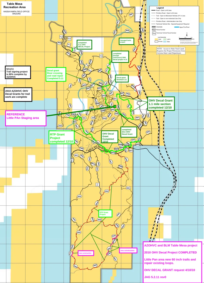
HASSAYAMPA FIELD OFFICE ARIZONA Table Mesa Recreation Area
NOTE: Access to State Trust Lands Requires the Proper Permission from Arizona State Land Department.
Not intended as a route access map. No warranty is made by Bureau of Land Management for use of this map for purposes not intended by BLM.
0 0.2 0.4 Miles Land Ownership BLM State USFS Private Legend
Technical Vehicle Site - Special Equipment Required Trail - Open to Motorized Vehicles 24" or Less Trail - Open to non-motorized Use Only Road - Open to All Uses Primitive Road - Open to All Uses
Primitive Road - Administrative Use Only
Interstate
9xxxRoute Number
TV-xTechnical Vehicle Route Number
Agua Fria River
completed 4.11 OHV DECAL Project Damaged lands project completed (except restrictors) OHV Decal project 4.11 completed 3/11 OHV Decal Grant OHV Decal Grant Completed 12/10 RTP Grant Project completed 12/10 RTP Grant Project Decal grant finished 5.11 new construction new construction
OHV Decal Grant 1.1 mile section completed 12/10 Decal grant
River crossing and road repair Completed 5.11 5/11/11
Trail signing project is 80% complete by AZOHVC
AZOHVC and BLM Table Mesa project 2010 OHV Decal Project COMPLETED Little Pan area new 60 inch trails and repair existing loops.
2010 AZOHVC OHV Decal Grants for trail work are complete
REFERENCE
___________________________________________________________________ AZOHVC
C/O Jeff Gursh Exec. Director Grants and Agreements 5402 East Grovers Ave. Scottsdale AZ 85254
BLM Assistance Agreement AZOHVC work
2010 BLM Table Mesa OHV DECAL Grant
OHV Decal Project completed
Services provided-
Work done, materials purchased or service provided:
Initial Grant project projected work
:-Construct 9 miles of new ATV /MC 50 inch route for Little Pan trail loop. -Construct 1 mile of Jeep Road to access rock crawler route closed by private property issues( upper terminator)
-Repair existing route that forms loop as machine accesses new route construction (22 mile total loop)
-install trail signs on loop and new routes.
-relocate plants disturbed in construction and replant at Little Pan staging area. Rehab 2 shooters dumps that are in new route vicinity.
Actual work completed:
*Construct 9miles of new 60 inch ATV/UTV/ MC route for little Pan trail loops. *Repair an additional 27 miles of existing jeep route in this trail area to allow safe connecting to new route. ( added the 9995, 9980,9981,9986A,9998 jeep routes to work)
*Construct 2.5 miles of Jeep Road to access 2 rock crawler routes ( upper *Terminator TV3 and added Lower Colateral Damage TV6)
*added Build access road to western River Crossing (9980A)
*added Rebuild the river crossing road at 9981 near the Gillette Mine .7 miles *added Rebuild the river access road 9986A. .5 miles
*Re-vegetate 2.4 acres of closed cherry stem road and shooting areas. Added 1.4 acres to rehab.
Project Costs:
Initial Grant project projected costs:
Requested funds for the BLM OHV Decal Grant project:
$32,380.00
Actual match for project:
OHV Decal Funds of $32,380.00 +
AZOHVC- $10,500.00 operator and worker labor$1000.00 additional Fuel Costs (4x4 club donation) BLM- $4000.00 Damaged lands fund to cover equipment rental Total Match to OHV Decal Grant this project $15,500.00
REF: Total project VALUE, including grant and donations = $47,880.00
PICTURE HISTORY
11/3/10…BLM AA DECAL project. Starting on reflag of new routes surveyed over 1 year ago for this project, start at Asco mine road and work west to the first staging area for reflag of 60 inch trail for Multiuse.
From staging area work west to BCT staging area flagging existing old sections and new tie in sections for this loop.Route #s9993 A,B,C,D. Layout the new river crossing off of 9995 and flag areas of the existing road to repair and add water controls.
9hours, 100 miles on truck 4 Runner. 2 volunteers 10 hrs
River crossing route flagging Trim tree and flag in
11/4/10…Meet with Tom B at Cemex mines. Cemex will allow storage of tractor trailer when needed for overnite safe location.
Back Down to river crossing at 9995. Chainsaw and brush out route for new road to river crossing. Will need additional signs at BCT trail intersection and courtesy sign for yield
Before brushing and limbing After 9hours , 100 miles on truck, chainsaw and loppers,
11/5/10… BLM AA DECAL project. Move in Sutter to recontour and close shooting are that over looks the BCT trail. Recontour main parking area BUT NOT the area with shell casings. Recontour road from Table Mesa in and plant cactus. See pictures
At same location , close hill climb and recontour the U shaped turn around off of Table Mesa road. AS of this date , blade can not be dropped on shell casing site to move any
dirt or add any dirt to change site. BLM Hazmat . 7 volunteers 12 hr
11/5/10 continued… Pictures (see map for location )
Shooters site before Start recontour
roll terrain to look more natural allow for drainage to continue to change contours.
Before rehab After rehab
As areas are rehabbed, ground is “tilled” to allow planting of cactus and native seed. This is done by hand. Barricades are used on Table Mesa road to warn of tractor work.
11/5/10 continued…
Hill climb before Hill climb after rehab
11/6/10… BLM AA DECAL project. Table Mesa cleanup. As part of the Table Mesa Cleanup, and BLM AA project, rake rehabbed areas from 11/5/10 tractor work and add
native seed ( 1 bag). 7 volunteers 8 hrs
Add local cactus, hedgehog , paddle and cholla, to area rehabbed.
Native seed , like everything in AZ, are needles that stick to everything!
11/6/10 continued…
Final , plants and seed rehab what it started as! 110 truck, hand tools, 8 hours labor (2) , 1 bag native seed
Clean up had over 450 volunteers work this day to haul trash and fill 4 dumpsters.
11/8/10… BLM AA DECAL project. move in Sutter Trail tractor from valley. Staging at BCT trail head area, work north towards river on 9995. added 29 water controls. Note: Horse trails (5) not using the BCT trail head area, currently using the shooters area across Table Mesa road to staging. They also do not run the BCT trail from the Trail head, the use 9995 to access the river section of the BCT. Also , out of the 5 horses we met at river end, only 2 would go over the step over gate and all used the new OHV river crossing to go back.
On return from River road construction, pick up down hill drainage skipped on way
down.(2.4miles repaired or built) 2 volunteers 12 hrs
BLM AA DECAL project. Start at BCT staging area end of the 9993 A, B C and D trail
segments.
Move high value plants as needed and replant. Trim trees as needed. Construct route to allow drainage with minimum grade dips to keep maintenance down.
River crossing area, SAND! Rough out crossing, fence to follow
Adding grade dips and drainage to existing 9995
Each grade dip is track packed and then sheep foot rolled to help controls last until a good rain hardens the site.
11/8/10 continued BLM AA DECAL project.
Heavy rock in areas slows work But , pays off in a stable trail tread
Side hill reduces visual impact to surrounding road views and reduces drainage issues
side trail site to rehab start with drainage cuts ………..spread seed and plant
11/9/10 BLM AA DECAL project
move in Sutter tractor , atv and equipment to continuing the work on the 9993 trail, 60 inch trail connector for new loop from Staging area………construct 1.1 miles from Black Canyon trail staging area to the dumpster site and future staging area to the east. Close 3
Heavy rock tree trim rather than remove
Winding routes control water Scenic views
11/10/10… Sutter and equipment maintenance 5 hours Volunteer time
11/16,17/10 BLM AA DECAL project.
Move in Sutter and ATV plus equipment for trail work and unload at the Asco mine road end of new section of the 9993. Working west from Asco mine Rd, construct 1mile of new 60inch trail to the Dumpster/ new staging area to meet up with completed 11/9 trail work. Close 3 illegal access points and at wash crossing harden lead in of north section trail hill climb. Drag trail and trim trees and brush as needed. Replant cactus and high
value plants as needed. 11 hr 2 Volunteer
Steep side slope below power lines Roll trail to reduce water damage
Rolling hills and side slope hilite this section of trail
OHV DECAL GRANT FUNDS WORK. 12/27 thru 12/31/2010. Start at Little Pan
Road trail # 9998, work North to 9990 start. Add grade dips to existing Jeep route that will become 60” trail.
Move high value plants as needed and replant. Trim trees as needed. Construct route to allow drainage with minimum grade dips to keep maintenance down.
1.2 miles in length of new route. Repair or maintenance work 7miles. See map for details. 12/27/10 …….Reflag the layout and pin flag grade dips and sign locations.
12/27/10 10 hours 2 Volunteer match
12/28/10 ……Move in Sutter Trail tractor to Little Pan Staging area. Move in ATV and trail drag. Start maintenance on the 9998 route( old rancher road). Starting at intersection of 9998, work down to the new section start of the 9990 60 inch trail. The 9990 starts in an old open pit mine area. Route is built on side slope to keep users on the route, add to the fun factor and help protect trail from water damage.
12/28/10 14 hours 2 Volunteer match
Open pit mine area, side slopes and drop offs
Benched trail on side slope, building sections of route in old mine area reduces impacts from new trail on land. Side slopes and mine area have additional seeding and cactus added to improve area vegetation. High value plants were relocated to bare areas of open pit mine.
Once out of the mine area, roll trail to reduce the need fro future maintenance. Add boulders to slow water at wash crossings
steep side slope drop to the 9990 wash area. This will loop back in the wash to the connecting section to the Little Pan staging area. 16 hours. 16 hr Volunteer help
Rough in trail tread Brushing on steep side slope
12/29/11…………continued
Minor hand work left and plant relocation is all that’s left on the steep side slope section
Note Sheeps Foot compacted trail tread Final “drag” of route to eliminate track
trail.
Install trail signs and final drag trail. Finish brushing route and finish relocation of high value plants. Spread native seed in areas near route to fill in vegetation. 60 gallon pull behind tank for final water of seed areas and rehabbed /relocated plants.
Trail signs and limited size of vehicle signs, steep side slope signs 9990
Relocated High value plants and Final tread and drainage on hill climb
native seed spread.
Trail signage by ATV with AZOHVC Final “drag” of trail takes track marks out
Rolling trail and out sloped tread allow water to shed off trail reducing erosion
Issues. This route now connects to a small wash that will run west to the next section of connecting trail to create this loop from the Little Pan staging area.
4/10 thru 4/21/2011 Table Mesa OHV DECAL GRANT FUNDS WORK. Start at Little Pan Road trail # 9990, work North to turn at restricted wash access to Gillette Property, rebuild to 60 inch trail, move trail out of wash and up on side hill to reduce erosion damage to trail and add restrictors at upper end (south end), Sign and brush. Working east from Little Pan parking area, construct connector 9990 segment to fence line, add restrictors for 60 inch OHV only. At Fence Line , add gate and signs, continue east to connect to 9998 trail. At intersection of 9998. Add restrictor and signs 60 inch OHV only and trail signs. Move high value plants as needed and replant. Trim trees as needed. Construct route to allow drainage with minimum grade dips to keep
maintenance down. 1.1 miles in length. See map for details.
Track Sutter (trail tractor) from little Pan up 9999 to TV 3 (5 miles). At new entry /reroute around private property, connect 9999 to TV 3 Rock Crawler route .3 miles constructed and signed, replant / move high value plants.
Working from the Gillette property(owner allows equipment storage) build the connector from 9999 to the bottom of the TV 6 Colateral Damage Rock Crawler route. This is an extreme Tech Vehicle route. Vehicles are over 100 inch wide. Last .3 miles in extreme side slope and rock ( Brown and Green Schist ) 4 t o6 foot side slope cuts to accomadate Rock crawler widths. Last 200 feet required an Excavator to safely dig side slope trail from bottom. This section was then finished graded and drainage added with Sutter Trail tractor. A fence was installed at the bottom of Route to keep users from straying onto private property at river. Additional signage denoting private property boundary was also added. Total ,1.4 miles.
Rehab 2 shooting areas and close off 2 illegal road entries and sign.
4/10/11………..AZOHVC match time and material /equipment. Reflag GPS tracks for this weeks trail work and repairs. Little Pan 9990, 9990A connectors and repairs. Locate restrictor points and drainage locations and flag. 100 miles truck , trailer and 60 on ATVs. 16 hours total volunteer time
4/11/11…..Move in Sutter tractor to Little Pan staging area. Starting in the NW , build new 4.5miles 60 inch connector to the fence line/gate. Build temp Gate and continue to the 9998 road that will complete the 9990 60 inch loop trail.
9990 looking east ATV drags trail as Sutter constructs
Heading north on the 9990 from Little Pan, convert partial Jeep road to 60 inch OHV route to complete 9990 loop. Route had been part of old haul road, and was depressed, cut new 60 inch route and add drainage off of and out of depression where possible. 120 miles truck and trailer,22 on ATV.
Depressed road, side cut to allow water to drain without damaging trail
One of the few areas t o drain water Move trail out of wash on old bench
install 60inch only signs and tee post supports. 16 signs and four plate signs, 10 tee posts and 8 channel posts. 200ft of fence wire, relocate and plant cactus. 100miles truck , 30miles ATV.
Haul in posts and signs use truck bed to pound channel posts
Add fiberglass signs and decals to posts with reflective tape and decals
add CLOSED DURING CONSTRUCTION signs to 9990 until all trail work is done.
Entry from Little Pan parking area. 9990 Loop runs east to 9998 and back on 9990 north. Wire gate will remain until BLM allows cattle guard use again.
Meet with Private Property owner at Gillette to see if we can park equipment on site to save hauling Tractor back and forth to city. Yes. Will store on site.
4/14/11…………Flag grade dips and final flag/layout of climb out of ravine at end of Collateral Damage Rock Crawler route. Figure distance Tractor will have to go (how many hours to track in). Meeting with Excavator operator on how to get equipment in and how much fuel will be need and how to get it to this remote area. Meet with ADOT on possible solution to Rock Springs road problems( right of way).
100 miles on Truck, 19 on ATV.
4/15/11…….Move in Sutter and trailer to be stored on Gillette property while working on Table Mesa projects. This save min. of $500 a day in transport to and from site. Saves on Fuel too.
From Gillette, track Sutter to TV 3 access route from 9999. Build .3 miles to access TV3 Rock Crawler route. Relocate cactus where needed and trim trees/brush. TM ranger will (Jason) will sign trail today.
TV 3 is 4 miles from Gillette, it takes 2 hours to tract Sutter to site. On way back , start on TV 6 reroute. This starts at 9990 overlook road and heads north crossing the old Dirty Sanchez route (now Closed). Build .6 miles of route before darkness calls a halt.
Final sheeps foot compact of trail finished trail to TV3 water fall obstacle
TV6 entrance rough in Over view of first section of TV6 route
New route crossing at Dirty Sanchez Fantastic view of eastern mountain range
Care has to be taken not to allow cross country travel and trespass on Private property ( river access at Old Gillette mine town now private). Additional Signs and “ghost fence” will be used to keep use on designated route.
Rookie filters will be constructed in two locations before route opens to keep OHV public safe and limit access to prepped Rock Crawler vehicles.
Heavy brush and steep side slope Full bench cut required on steep slopes 4/16/11…..5 AZOHVC member club workers( AZ Rock Rats) help with brushing. Continue working with Sutter Tractor to build thru steep side slope area and rock. .2 miles roughed in today. Move excavator in to lower Colateral Damage entry point from Private Property for start of work.
Go over Rookie Filter design. 8 hours Volunteer time x 5
Side drain forces steep climb of trail………….outslope to prevent erosion
Fill trench on private property and build bench for Excavator to start side slope work.
4/17/11………pick up a 50 gal. Fuel tank and electric pump assy. Assy and hook up electrical , test and fill with 50 gal diesel fuel($4.20/gal) This will get Excavator started on 4/19. “build “ 6 more trail signs and NEW OHV DECAL PROJECT sign.
lets public know funds are working! 4/18/11………..Track in 3 miles, extreme rock and side slope .2 miles completed today. Heavy brush must be cleared so as not to bury debris. Chainsaw /trim trees, remove viable cactus for relocation. Fill excavator (50 gall).
Trim trees on final down hill to CD. 100miles truck and 30 ATV.
Building side slope trail 1) 2) 3)
Final section before drop into canyon bottom of Collateral damage. Push materials from bench cuts(slot dozing) for down hill road bed.
*** AZ Rock Rats donated 4 55 gal drums of Diesel fuel to Operate Excavator on OHV projects. This will run Excavator for 8 hours.
4/19/11….. Working from bottom of Collateral Damage, cut in road (rough in only). Excavator pulls materials and cuts rock for down hill section on canyon wall. Due to extreme side slope and steep terrain, excavator can not make it to the top. 6 hours. 100 miles truck, 29 ATV.
Sutter trail tractor finished the turn at top and cut thru to excavated section, building a road bed from materials loosened by the excavator. Drainage was added and a bench turn at the bottom was constructed to access the rock crawler route.
Build bench for excavator to sit on cut in road base
Pull out materials and drop on outside edge of road bed, Brown Schist makes an excellent road bed and surface. Sutter will finish road surfaces and drainage. Care must be taken to keep fines and lose materials out of wash bottom.
High Value plants were relocated to lower river area for holding banks together for erosion control.
Working from top, Sutter Tractor cut thru 4 feet of rock to build turn
Excavator deposited materials Finished graded road
Take Sutter back out , widen narrow areas for 100inch road bed. Track back.
4/20/11…. 1 roll smooth fence wire, 12 tee posts , 2 channel posts, 20 stays, 5 signs. Fence lower access to private property/ river. Excavator will dig trench to restrict access from vehicles. Install private property signs and trail TV 6 signs. Replant high value plants removed for road construction ( bare areas of access road). Finish grade with Sutter , lower section near Dirty Sanchez. Track out.
looking at start of CD route note fence in back ground. Sign let you know exit and
stay on designated route. 1st trespass closes trail for 1 month , second for 2, third
permanently closes trail.
4/21/11…… Install private property signs, TV 6 trail markers, closed during construction and tee post barriers, additional decals and arrows. 6 tee posts , 9 signs.
TV 6 trail markers Private property signs
4/27 thru 5/3/2011 OHV DECAL GRANT FUNDS WORK.
This is a full size Jeep road project.
Savings on time and material on other projects allowed the addition of this project to the OHV Decal Grant.
Start at Asco Mine Road # 9999, work west on 9981 repairs. This route is access to River crossing and part of the loop trail from Little Pan staging area. Steep down hill to river and 2010 floods put 20 feet of sand on existing road. Start with Excavator and pull boulders from road bed, trench for water control bases. This project will repair and rebuild road on both the east and west side of river. Routes in project are 9999, 9981, 9998A, 9986A and 3 drainage channels. Harden river crossing is also part of this project. Move high value plants as needed and replant. Trim trees as needed. Construct route to allow drainage with minimum grade dips to keep maintenance down.
Starting on 4/27,28, 29/11 (20 hr)………final pin flagging of repairs and work to be done. Tag plants to move and relocate( TV3 area). Trim trees at river where trees were up rooted by flooding. Flag drainage areas to build on west side of river and tag plants and set grade on drainage channels. Locate Boulders for closing two illegal access point to river. Mark fence locations. Move in all equipment.
5/1/11 Starting with excavator, pull river rock and boulders from existing road bed. Set
elevation for grade dip drainage and rough in 2 locations on 9981. Move Excavator to river area to remove sand from road bed. Move in Sutter trail tractor to finish grade road base and build grade dips and side drains. Move in End loader to haul out any remaining boulders and large rock pulled during this operation. Make two passes with water truck to control dust and pack graded road bed base. Sutter follows Excavator as it clears sand and grades to road base all the way to river. Sand is removed and piled above river for final use as top for AB road mix. Use excavator to block roads created to bypass flood damaged 9981.Place barricades to close during construction and to protect public. . Equip. used ; end loader, dump truck, water truck, excavator, sutter trail tractor , ATV. 2 volunteers and one operator.
5/2/11 Haul in AB road mix. Working with Dump truck and Sutter trail tractor, rough
spread road mix down to river. With Sutter, grade out first road mix. Apply water and pack first course with loaded end loader (wheel pack). Second course of road mix with sand mix applied and spread with Sutter and sheeps foot packed. Apply water again and let set. Finish upper grade dip run offs and build silt traps. Close upper social route with berm and replant.
At river, grade thru river rock to create a road bed that has a wind row on each side from moved top river rock. See pictures. Harden river crossing with river rock. Using 1 to 3 inch river rock and end loader, upper area of road that was buried by sand and debris, add river road to road bed to allow water to drain thru / off. Top with road mix /sand mix. Compact and water. Starting on west side of river, pull boulders and debris from rd# 9986A as it comes down the hill to river area. Using Excavator and Sutter, set grade for base. Excavator creates roughed in water controls and drainage channel. On upper
sections of 9998A and side route, use Sutter to build 5 grade dips and side drains to allow water to shed from road before damaging hill climb. Use end loader to move needed road mix and rip rap for drainage hardening for tomorrows work. Equip. used ; end loader, dump truck, water truck, excavator, Sutter trail tractor , ATV. 2 volunteers and one operator.
5/3/11 Continue work on west side of river Roads# 9986A, 9998A and side road.
Using dump truck and end loader, haul apply AB road mix and grade out with Sutter. End loader to dump rip rap for side drains and Sutter grades out. Finish Drainage Channel with Excavator and move back to river. Using end loader , close with berms illegal river access. Sutter final grade of all roads and road mix. Water all surfaces, Wheel pack with endloader. Finish grade dips on upper 9986A.
At river area, finish road to river , water and pack. Install fencing at areas where needed, install new trail signs and area info signs. Install new signs at intersection of 9999 and 9986A noting RIVER ACCESS. Install OHV DECAL project Signs. Move high value plants as needed and replant on closed area berms. Trim trees as needed for safe river
Project picture history
5/1/11
River crossing before(flood damaged) River crossing after!
Rd# 9981 River crossing /access. Major erosion damage and blocked at river, this is one of only tow routes that access the north half of the Table Mesa Project. This road has been impassable for more than a year. Miners in past had graded to point that no water could leave road way and erosion damage made route almost un-useable.
Excavator Roughed out road bed Start Sutter tractor grading
Rough graded road is watered down to reduce dust and pack route before AB road mix is added. Remaining side cast rock will be removed.
Road mix is spread after each dump of materials, Work from top to River.
At river end of road, 15 to 20 feet of sand had to me moved to get back to original road bed. Here Excavator and Sutter work to move materials.
East side of river thru river rock, create a defined “route “ for road to follow. East side road number # 9986A and 9998A and side road hill climb repairs
Start of water control Finished water control
Start grade work to protect road out of river area from erosion water runoff
Drainage to protect road from water damage is most important feature to add.
This water control with side drain channel filled with Rip Rap will protect the hill climb road out of the river bottom from water draining from mountain roads above.
Roads leading to this area also have water controls added to reduce the amount of force water has (energy) to cut thru road. Reduce the erosion reduces the cost to maintain and keep routes open.
Material Berms with fence backing , close off illegal access to areas protected under BLM EA. Native Seed and plants will be added this the berms with monsoon rains.
Fencing was installed in areas in addition to signs to keep users on designated routes.
Final compacted 9981 river access route allows users to access northern routes and improvements, Future project will make improvement to area just south of 9981 for . river access for fishing and camping.