www.scienceworldjournal.org ISSN 1597-6343
Assessing the Socio-Economic Impact of Gully Erosion in Chikun Local Government Area, Kaduna State, Nigeria
ASSESSING THE SOCIO-ECONOMIC IMPACT OF GULLY
EROSION IN CHIKUN LOCAL GOVERNMENT AREA, KADUNA
STATE, NIGERIA
1*Aliyu Hassan Ibrahim 2Nura Alhaji Yaro 3Abiodun Olufemi Adebola
1*Department of Environmental Science, College of Environmental Studies, Kaduna Polytechnic, Kaduna. 2Department Of Geography, Northwest University, Kano.
3 Department Of Remote Sensing and GIS, Federal University of Technology Akure,(Futa), Ondo State.
Corresponding author: aliyuibrahim07038@gmail.com
ABSTRACT
The earth’s landforms are closely inter-related and some of the observation which has been made with the passing of time shows that these landforms are acted upon by the processes of erosion causing the landforms to undergo a progressive change from initial forms sequentially to ultimate forms. The aim of this study is to assess the adverse social and economic implications of gully erosion hazards in Chikun local government area, Kaduna State, Nigeria. The study intends to identify the percentage of the residents according to localities that have suffered socially and economically from gully incidents. It also intends to determine the relationship between adverse social and economic effects suffered by the affected people in the various localities of the study area. The settlements studied are in Chikun local government area, Kaduna State Data for the study was collected from two major sources; primary source and secondary source. Primary source of data are direct observation from fieldwork and the use of questionnaire while the secondary source include topographic map and library materials. Descriptive statistical tools were applied to deal with the techniques of summarizing and describing data collected. Percentages, proportion and mean were applied to get other parameters such as expected frequencies. Pearson’s co-efficient of correlation was used to analyze the relationship between the social and economic effects of gully erosion in the area. The study recommended that an integrated catchments drainage system is lacking in the study area and this can be controlled. The control is surface run off and maintenance of stable soil slopes in gullies involves engineering schemes.
Keywords: Gully Erosion, Social, Economic, Impacts,
Environment, Soil
INTRODUCTION
Soil erosion, including gully erosion, is a serous global problem, and is difficulty to assess reliably and precisely its dimensions, economic and environmental consequences (Egboka, 2010; Ibrahim, 2014). Onyegbule, (2005) noted that impacts maybe adverse or beneficial and the same impact may be viewed differently by different stakeholders or affected groups as very few significant environmental impacts affect all individual and social groups equally. Egboka, (2010) noted that the greatest impact of erosion in Nigeria lies in the outright volumetric loss of soil and
decrease in nutrient capacity, moisture retention capacity, organic matter content and the depth of soil.
Ofomata, (2010) reported that up to 50% of annual rainfall in the tropics can be lost from eroded slopes due to decreased infiltration and high surface runoff. The downstream effects of this loss, according to the author, are increased flood peaks with high sediment load, from denuded surface areas. The increased sediment load results in faster filling of those reservoirs and shortens their useful life (Onyegbule, 2005; Cavey, 2006: Egboka, 2010).
This geomorphic event may degenerate into sheet, rill or gully types of erosion (Jimoh, 1999; Egboka, 2010). Sheet erosion is essentially a process that involves the uniform removal of soil surfaces, which is when the soil surface is undergoing a uniform degradation. Rills are parallel grooves of little depth covering the land surface which can easily be filled through normal cultivation; formation of rills is one of the consequences of flow water.
Sheet and rill erosion are the fore runners of gully erosion representing the incipient stage of the development of gully erosion (Oyegun, 1980; Bergsma, 1981; Jimoh, 2003). Gully erosion is any erosional channel that is so deep that it cannot be crossed by a wheeled vehicle or eliminated by ploughing, unlike rills which can easily be filled through normal cultivation.
The major agents of soil erosion in the tropics includes rainfall, while some of the attributes of rainfall are; intensity, duration, drop-size, amount and frequency. other factors that contribute to the occurrence of soil erosion in the tropics includes soil type and its characteristics, topography, geology, cultural practice carried out in the region and conservative practice applied to the land (Faniran and Jeje, 1983; Davies, 2000; Ibrahim, 2014).
Gullies are formed as a result of a combination of climatic and human influences. For instance, over-cultivation of land in certain parts of Kaduna State has resulted in gully erosion and such arrears include the Kakau, Kuriga, Gwagwada, Kujama, and most farmlands in Chikun local government area, Kaduna State such as Kunai and other neighboring villages.
At Chikun local government area, Kaduna State, each rainy season is associated with nightmares, particularly for inhabitants
Fu
ll L
en
gt
h Rese
ar
ch
Ar
Assessing the Socio-Economic Impact of Gully Erosion in Chikun Local Government Area, Kaduna State, Nigeria
living at the proximity of erosion sites. Each gully incidence is accompanied by landslides and slumping, leaving at the end of each event inhabitants crying and mourning for loss of agricultural lands, ancestral lands, homes and economic trees (Egboka, 2010). The cumulative effect is that the affected inhabitants are left homeless and/or jobless. The threats posed by gaping and daunting large gullies to farmlands, settlements, roads and human are enormous. Most communities in Kaduna State have been ravaged by soil erosion of different dimensions. Sheet erosion is common and it has resulted in the reduction of soil fertility. Rill erosion is also common in many communities.
Consequently, Kates and White (2008) concluded that hazard occurrences merely represent the extreme of natural processes and their distributions and in a slightly different context would often be regarded as natural resource. The study is based on this theory.
Fig.1: Natural Hazard as an Ecological Framework.
Source: Burton, Kates and White (2008).
The incidence of gully erosion in Chikun local government area, Kaduna State is not new, as it has formed a subject for research. Unfortunately, until now, most researchers are confined only to the factors causing gulling and control measures, keeping the losses sustained and other social and economic effects suffered by the affected people aside (Sparks, 1995; Indraranta, 2008). It is of utmost importance to study and document the losses suffered by soil erosion victims in terms of social disruption, psychological effects and economic effects with a view to attracting Government, (State and Federal) to bring lasting solution to Chikun local government area erosion ravaged areas.
This study is mainly on the assessment of gully erosion effect on the inhabitants of KurminGwari. Burton et al., (2011) utilizes questionnaire as a tool for psychological enquiries into hazards. This will be employed in this study. This model gives man a central role and it is armed with ecological frameworks that involve the use of psychological enquiries.
Chikun local government area is one of the most prominent local government areas in Kaduna State because of its proximity with the metropolis. It has its headquarter in Kujama town. It is located between latitude 10°31′500″ North and longitude: 7°27′400″ East and occupies an area of approximately 4,645 square kilometer and has a population of 368,250 (NPC, 2006). The objectives of this study include, identifying the adverse social- economic impacts that resulted from gully erosion and determining the size of residents in various localities in Chikun local government area, Kaduna State this elucidate the common adaptive measures and their sustainability.
MATERIALS AND METHOD
Data Collection
For a reliable and proficient result in this study, structured questionnaires were administered to the gully affected areas by the researcher. Four hundred structured questionnaires were administered; eighty to each of the five erosion areas within Chikun local government area, Kaduna State; they include Kunai, Gwagwada, Kakau, Kujama and Kuriga.
Sampling Method and Sample Size
Simple random sampling was adopted in the course of this research for the purpose of selecting households and respondents affected by gully erosion living at the gully proximate areas. Respondents were also selected from heterogeneous populations that make up gully affected migrants and other unaffected living populations of Chikun Local Government Area. Respondents comprise only of stakeholders from Kunai, Gwagwada, Kakau, Kujama and Kuriga communities of Chikun local government area, Kaduna State. The instrument used in data collection include, observation, questionnaire and measurements while Descriptive statistical analysis was applied to deal with the methods and techniques of summarizing and describing information (data).
Table 1: Collation of Questionnaire Instrument.
Source: Field Work, 2016
In the course of carrying out this research, 400 (four hundred) questionnaires were distributed to the five gully erosion prone areas of Chikun local government area, Kaduna State, between April, 2015 and August, 2015. The distribution was evenly done, eighty (80) to each of the gully affected areas. The percentage return rate of the questionnaires is 93%, showing that 400 questionnaires were distributed and 372 questionnaires were returned and properly filled.
RESULTS
The data collected for this study are presented and statistically analyzed using frequency distributions, proportions, percentages and tabular presentations.
Description of Gully Complex
Chikun local government area reveals frightful scenic environments. These areas show the existence of tracts of base lands devoid of topsoil from sheet and gully erosion criss-crossing farmlands.
Assessing the Socio-Economic Impact of Gully Erosion in Chikun Local Government Area, Kaduna State, Nigeria
Plate 1: High Wall of Erosion Complex
Source: Field Work, 2016
Plate 2: A House Threatened by Gully Erosion in Chikun LGA
Source: Field Work, 2016
Plate 3: High Wall of Erosion Complex Standing like a Cliff (Researcher coming down the Cliff)
Source: Field work, 2016.
Cross Bed Analysis
A total of 30 cross beds were measured at KurminGwarigully site. This was done with the help of Bruton Compass to measure the dip and azimuth of the observed cross beds.
Assessing the Socio-Economic Impact of Gully Erosion in Chikun Local Government Area, Kaduna State, Nigeria
Table 2:Cross Bed Data of selected points in Chikun LGA
Sandstone
Source: Field Survey, 2016
Table 2 revealed 30 cross bed azimutal and dip measurements obtained from the selected sample point in Chikun LGA gully erosion site. The palaeocurrent direction showing a unimodal pattern in a north-east current direction and other supporting evidences can be used to trace the possible source of the Sandstone in the study area. Palaeocurrent study reveals a Northeastern provenance. The general strike direction is N285W, S105E with average dip amount of 35o.
Demographic Structure of Respondents:
Table 3 shows the demographic structure of the respondents. At Kunai 38.75% are males, 61.25% are females. At Gwagwada 43.59% are males and 56.41% females. At Kakau, the table shows that 33.75% are males and 66.25% are females. At Kujama and Kuriga 37.10% and 41.67% are males, whereas 62.90% and 58.33% are females respectively.
Table 3: Demographic Structure of Respondents
Source: Field Survey, 2016
Table 3 shows that on the whole 38.98% (approximately 39%) males and 61.02% (approximately 61%) females comprise the gender structure of the respondents.
Age Structure of Respondents
Table 4 shows the age distribution of the respondents. The table shows that at Kunai age below 25 years constitutes 3.75% of the respondents while 26-45 years make up 25%. 46-65 years comprise 71.25% of respondents. At Gwagwada 2.6% is below
25years, while those between the ages of 26-45 years and 46-65 years make up 23% and 74.4% respectively.
Table 4: Age Structure of Respondents
Source: Field Survey, 2016.
2.5% of respondents are below 25 years. 28.75% and 68.75% are between the ages of 26-45 years and 46-65 years respectively. At Kujama, those below 25 years are 8%, those between 26-45 years are 22.6% and those between 46-65 years are 69.4%. At Kuriga, 5.5% make up those below 25years, while those between the ages of 26-45 years and 46-65 years make up 23.61% and 70.83% respectively.
On the whole, about 4.3% are below 25 years, 26-45 years constitute 24.73% while respondents between the ages of 46-65 years make up 70.97%. This shows that ages 46-65 have more knowledge of erosion in the area and has been greatly affected over the years.
Social Impacts of Gully Erosion in Chikun Local Government Area
Table 5 shows the social effects of gully erosion in Chikun Local Government Area, At Kunai 65% of respondents are affected by destruction of ancestral homeland by gully erosion. 100% are affected by loss of source of water supply. 72.5% find the gully site frightful. 92.5% experience trauma as a result of gully erosion in the area and 57.5% lost relatives.
Table 5: Social Impacts of Gully Erosion
Source: Field Survey, 2016
At Gwagwada 71.25% of respondents constitute those that suffered from destruction of ancestral homeland. 100% comprise those that lost source of water supply. 68% 75% and 90% are those that find the gully sites frightful and those that experienced trauma respectively as a result of gully erosion.
67.95% affected by loss of ancestral homeland in Kakau, All the respondents are affected by loss of source of water supply, while 71.79% and 91.03% find gully sites frightful and experience trauma respectively. 51.28% lost relatives in Kakau. In Kujama 16.13% agree to have lost ancestral homeland, while 100% of respondents lost sources of water supply. 69.35% find gullies frightful, 88.71% experienced trauma as a result of gully erosion in the area, and 58.06% lost relatives. At Kuriga, 11.11% are affected by destruction of ancestral homeland, 100% lost source
Assessing the Socio-Economic Impact of Gully Erosion in Chikun Local Government Area, Kaduna State, Nigeria
of water. 69.44% are frightened by the erosion, 90.28% experience trauma and 44.44% lost relatives.
Economic Impacts of Gully Erosion in Chikun Local Government Area
Table 6 shows the economic effects of gully in the study area. 38.75%, 30%, 61.54% suffered from loss of building and furniture in Kunai, Gwagwada and Kakau respectively. 92.5%, 87.5%, 80-77%, 24.19% and 11.11% are affected by loss of farmland in Kunai, Gwagwada, Kakau, Kujama and Kuriga area respectively.
77.5% Respondents in Kunai suffered from loss of planted crops, and 97.5% lost of economic trees 81.25% and 90% of respondents lost planted crops and economic trees in Gwagwada respectively. In Kakau 80.77% lost planted crops and 82.05% lost economic tress while 64.52% and 96.77% suffered the lost of planted crops and economic trees respectively 100% of all respondents from Kunai, Gwagwada, Kakau, Kujama and Kuriga lost money as a result of community contribution to gully erosion in the area. In Kuriga 44.44% lost planted crops and 97.22% lost economic trees.
Table 6: Economic Impacts of Gully Erosion
Source: Field Survey, 2016
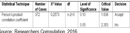
The study revealed that therre is no significant relationship between the social and economic effects of gully erosion in Chikun Local Government Area”. The Ho attempts to compare the difference that exists between the adverse social and economic impacts of gully erosion in Chikun Local Government Area.
Table 7: Summary of correlation analysis for social impacts of
gully erosion in Chikun Local Government Area
Source: Researchers Computation, 2016
The correlation analysis computed for the relationship in the extent of the adverse social and economic impacts is 0.2573. The critical values at 0.10 and 0.05 are 1.7638 and 2.353 respectively. The decision rule is, reject Ho if the calculated value of chi-square (0.2573) is greater than the critical values at 0.05 which is 2.353; also at 0.1 the critical value 1.638. Therefore, Ho is accepted since the calculated value is less than the critical values. Hence it is concluded that “There is no significant relationship between the social and the economic impacts of gully erosion in Chikun Local Government Area”.
Remediation Measure for Gully Erosion Menace
The menace of gully erosion in Chikun Local Government Area has called for urgent remedies in order to arrest further loss of
arable land, buildings and other properties, transportation and communication links. The long term weapon in controlling gully erosion is vegetation but structures may be required to stabilize a gully head or to promote siltation and vegetative growth in the gully floor. A good reason for this is that while structures may be subjected to decay and become less effective over time, vegetation can multiply and thrive and improve over the years. For a long term success of gully stabilization, a good vegetative cover has to be established on the gully floor. This will prevent further gullying and allows the gully floor to gradually silt up reducing the fall over the gully head. Using wire netting, logs or concrete a series of small weirs can be constructed to trap sediment as well as encourage vegetative growth.
Conclusion and Recommendations
From the analysis on the social and economic effects of gully erosion in Chikun Local Government Area, the study concludes that our environment is a part of our social and economic survival and what happen within the environment we live can impact negatively to our survival. More so, for greater effectiveness, the solution to gully erosion impact is to treat.
Gully Erosion menace is one phenomenon to which the adage, “A stitch in time saves nine” is most applicable. A number of the severe and devastating gullies would not have resulted had they been attended to at their incipient stages. It is against this background and based on the findings of this study recommended that the effects due to gully erosion and other natural environmental disasters make the need for an integrated environmental planning and studies very important and urgent. That most of the human activities observed during the study portrayed lack of awareness by the generality of the populace, of the nature and action of erosion as well as of the consequence of their activities and tree planting campaigns should be intensified and there should be legislation/laws for aforestation and against deforestation. Enlightenment and consciousness in erosion control should include land use habits of the people in their agricultural practices and care vegetation
.REFERENCES
Bergsma, K. (1981). Quantification of soil loss and sediment produced from eroded land. American Journal of soil science. Vol. 46, Pp 300-302.
Burtons, I.; Kates, R. W.; AND White, G. F (2011) “The environment as Hazard” Oxford Unv. Press N. Y Pp3-6 Cavey, B (2006) Gully erosion, Department of Natural Resources
and Water. Fact sheets L.81. Pp. 1-4.
Davis, W. W. (2000)” Environmental impact studies on erosion affected parts, of Boston” geographical essays. Boston. USA, Pp. 77-78.
Egboka, B. C. E. (2010) “Type and causes of soil erosion”. Paper presented at the workshop on soil erosion Nigerian Society of Engineers. Enugu.
Ibrahim, A. H. (2014). Minimizing the Problems of Gully Erosion in Kaduna Metropolis. Paper Presented at the Maiden
Departmental Seminar of Department of
Environmental Science, Held At Hnd II Environmental Technology Classroom, College of Environmental Studies, Kaduna Polytechnic, Kaduna.
Assessing the Socio-Economic Impact of Gully Erosion in Chikun Local Government Area, Kaduna State, Nigeria
Indraranta B. (2008) “Investigating Erosional Behaviour of chemically stabilized Erodible soils; Geocongress 2008, New Orleans, Geosustainability and Geohazard Mitigation GSP178, Reddy, K.R, Khire MV, Alshawabkeh, AN (eds) 2008, Pp. 670-677.
Jimoh, H.I. (2003). Erosion Tolerance Range of Landuse and Management Techniques in Ilorin, Nigeria. Intern journal. Environ studies vol. 60 (5). Talyor and Francis group.
Jimoh, H.I. (1999). Effects of run-off on sediment transportation and deposition in Ilorin City. Nigeria. Centre Point Journal vol.7. No2. Pp. 97-100.
Kates, R. W. (1971) “National hazards in human Ecological prospects Hypothesis and model” Econ. Geog. Vol. 47: Pp 438
NPC, (2006). Population and Housing Census, 2006. National Population Commission, Abuja, Nigeria. Ofomata, G. E. K. (2000) “Erosion in the rain forest of Nigeria”
Paper presented at the annual conference of the Nigeria geographical Association, University of Nigeria, Nsukka.
Onyegbule, P. (2005) “ Geophysiographic factors of Agulu-Nanka gully Erosion Southeastern Nigeria” Seminar paper presented to Department of geography, Met and Environmental Management, Nnamdi Azikiwe university, Awka.
Oyegun, R.O. (1980). The effects of tropical rainfall on sediment yield from different land use surfaces in sub-urban Ibadan. A PhD Dissertation submitted to the Department of Geography, University of Ibadan. Nigeria, Pp. 80-82. Sparks, B.W. (1995). Geomorphology; geographies for advanced
study. Love and Brydone Pp. 50-54.