Developing Multi-Criteria Decision Making And
Geographic Information System Based Framework
For Effective Delivery Of Emergency Obstetric
Care Services In Tanzania
Job A. Chaula
Ardhi University, Department of Computer Systems and Mathematics Tanzania [email protected]
Abstract: Effective delivery of basic emergency of Emergency Medical Services (EMS) is still uncertain in rural and urban area of Tanzania. Two factors contribute to ineffective deliveries of (EMS) which are absence of a coherent policy on Emergency Medical Services (EMS) and normative framework to support EMS implementation which both have resulted to imbalance in EMS distribution patterns within rural areas. In attempt to address the challenge, this research study used Multi-Criteria Decision Making (MCDM) and Geographic Information System (GIS) to explore the policies and developing framework for effective delivery of Emergency Obstetric Care Services (EmOCS) in Tanzania. The research study reviewed the planning policy documents and approaches used to plan the EMS facility location for the better understanding of their strengths and weaknesses related to the desired location-allocation. Furthermore, the research integrating Multi-criteria Decision Making (MCDM) with Geographic Information System (GIS) techniques to develop an effective framework to support inclusive planning practices of location-based health services in Tanzania. Complex array of decision criteria including environmental, technical, economic, and social issues related to life saving were analyzed by integrating Multi-criteria Decision Making (MCDM) with Geographic Information System (GIS). The developed framework serves as tool for future planning EMS in urban and rural areas of Tanzania and Africa in large. The framework helps to determine the optimal EMS facility locations by considering the appropriate strategies for facility deployment which is to maximize the EMS coverage; the number of facilities assigned to each demand point (facility quantity); and the distance up to which a facility should service a demand point (EMS quality).
Keywords: Emergency Medical Services, health facility, location planning, MCDM, EmOC .
1.
Introduction
Across developing countries, health services are limited to small geographical areas; improvement on health services access and reduction of barriers to access health services are the common agendas [1]. In health care services the location of facilities is critical. Poorly located facilities will cost the lives of people by leaving some areas not adequately covered with health services. With high medical emergencies requirements in many parts of the country, effective planning and allocation of health facilities to provide emergency medical services (EMS) is crucial. EMS facilities are required to provide services efficiently and effectively to a wide catchment area in order to cover demands which are spatially distributed. For the dispersed population, geographical accessibility to services is a necessary prerequisite in planning process. Services must be situated in a position where the majority can access it in timely manner. Optimal location of health care facilities is one of the active topics in health informatics and GIS operational researches [2]. Decisions for resource allocation are still made uninformed based on the past experiences of administrative or political consideration rather than real existing situation [3] & [4]). For better understanding of the current and future access to health services, healthcare administrators require analytical tool to support them in decision making. Information and communication technology (ICT) is incorporated into spatial planning practices through the introduction of GIS applications tools. Studies show that there is weakness in provision of medical emergencies in developing countries especially the rural communities which often suffer inadequate medical services [5]; [6]. In Tanzania, report shows there is low geographical coverage of health services in remote areas [7]. The effect of distance in
accessing health services is a well-known fact. The problem in medical emergencies service location is to identify optimal locations for the medical emergency care facilities so as to maximize access to urgent medical interventions. Lack of proper detailed framework to guide planning medical emergencies service location based on the characteristics of emergency services is a major obstacle in developing countries [5]. Frameworks used currently in Tanzania for planning health services underrate the use of ICT in spatial planning processes; the health facility accessibility is estimated based on the Regional Availability method which is based on the ratio of number of people living in a particular area to the number of health care facilities [2]. Such frameworks are not capturing parameters like time or distance travelled, road or route characteristics to reach the facility and reality of short distance/time required for life-saving medical attention. The objective of this research was to analyse the spatial distribution of Emergency Obstetric Care facilities in Kinondoni and Kisarawe districts and hence identify the strengths and limitations of facility location models and GIS application tools used to plan such services. The challenges found were used to improve the planning of emergency medical services location by developing a framework for planning emergency medical services location.
1.2 RELATED WORK
1.2.1Frameworks for Location Decision Making
frameworks. Few methodologies for developing frameworks
have been documented; most of them admit the examination of existing solutions as a starting point. Manipulation of spatial and non-spatial data and the management of multiple decision-making criteria are the challenges facing the decision makers [8]. Various techniques are employed to solve sitting problems which include GIS and Multi-criteria Decision Making as described below;
1.2.3GIS-based Multi-Criteria Decision Making
Approach (MCDMA)
MCDM can be defined as a decision-support and mathematical tool allowing the compound conflicting criteria to be officially included into the management planning process [9]. Different alternatives or scenarios are evaluated based on multiple criteria. Each criterion is weighted, relative to its importance in the overall picture among all the rest. Then each alternative is scored alongside each of the criteria, based on how well it satisfies it. Finally, the scores are multiplied by the weightings and the grades for each alternative are added up, to give a ranking for that alternative. The advantage of MCDM is that it gives an objective view of how suitable any alternative is. Various studies have been done on the area of GIS and MCDM techniques. [10] used these methods to evaluate locations of solar farms in south-eastern Spain. Constraints or restrictive criteria and weighting criteria were the two types of criteria reflected in GIS. The first type of criteria was used to reduce the study area by leaving those areas that avert the implementation of the project. The later criteria type focused on those factors influence capability to solve the actual alternative according to the objective to be reached. MCDM evaluation of the potential sites to position a solar plant was done based on the analyses and computations of weights of the selected factors. Analytic Hierarchy Process (AHP) was used to analyse factors and the evaluation of alternatives relative to their degree of adequacy was carried out through the TOPSIS method (Technique for Order Preference by Similarity to Ideal Solution).
1.2.2Integrated Approach to Multi-Criteria-based Health
Care Facility Location Planning
Methods from three research topics are combined in integrated approach to solve the problems of planning preventive health care facility location [2]. Health accessibility estimation method describes the level of patient‟s proximity to the health care service. This method uses two GIS-based accessibility categories; the shortest time/distance taken by patient to reach the nearby health facility and the regional availability method which focuses on the proportion of the number of people living in a particular area to the number of health care facilities. The shortest time/distance method is appropriate for planning emergency medical services location and can be complemented by regional availability method. [2] approach uses the facility location planning method which considers the location criteria, facility location model, and spatial analysis algorithm in planning processes. Criteria such as efficiency and equity which are focusing on optimization of accessibility standards of the target area for optimal and uneven distribution of health care facilities are highly considered. The third method used is location evaluation whereby the existing health care facilities with the optimal solution given by the facility location planning method are
compared. This method helps to forecast the service pattern of the facility. The optimal solution can be modified by forecasted results. Proximity analysis is an example of the most used location evaluation methods. Characterization of the features of existing facility locations such as proximity to a highway is possible when using proximity analysis. Planning can be guided through such location features.
3. METHODOLOGY
3.1 Research design
A mixed research methodology has been used to conduct this study. Both qualitative and quantitative techniques were applied in this GIS-MCDM based research. The case study was used as a research design approach and applied in qualitative research method for this study as presented in Figure (1). The study focused on the geographical distribution of Emergency Obstetrics Care Services (EmOCs) in Kinondoni district Dar es Salaam region and Kisarawe district in Pwani region Tanzania.
3.2 Qualitative data collection
Within the districts, researcher interviewed five (5) Council Health Management Team (CHMT) members and one (1) District Reproductive and Child Health Coordinator (DRCH-CO) from each district making a total of twelve key informant interviews. CHMT members were purposively selected because their direct involvement in the process of health services planning and DRCH-CO are responsible for coordination of reproductive and child health services including EmOCs. In order to adhere to the research standards ethical principles, oral informed consent was obtained from the respondents prior the interview. Primary data was collected through semi-structured key informant interviews looking for the complex and informal aspects of planning medical emergency services location which are not well defined in published literature. Secondary data was collected through published literature review and public policy documents.
The guideline for planning health services in Tanzania
especially MMAM, UN Guideline for monitoring the availability and use of obstetric services together with a handbook for monitoring these services were among the reviewed documents. The population used to calculate the UN minimum accepted level was as per [11]. The geo-coordinates of EmOC facilities together with the shapefiles of wards for the selected districts were obtained from Ardhi University. Content analysis method was used to analyse the qualitative data. Data collected through interviews, literature review and document analyses were triangulated to obtain the common understanding. ArcGIS 10.2.1 software was used to analyse the geographical distribution of EmOCs in selected districts.
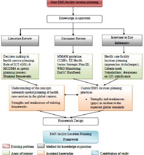
3.3 Development of the EMS framework
Development of the framework was possible following the knowledge acquired from different school thoughts supporting the optimal health facility location planning (Figure 3.1). The acquisition of knowledge was possible through literature review, document review and interview of key informants (CHMT members). The planning frameworks and approaches used to plan facility location were studied for the better understanding of their strengths and weaknesses related to the desired location-allocation.
3.3.1 Stages in development of the EMS framework In the context of Emergency Medical Service location planning, a framework is a tool to improve planning and management of EMS locations as the delivery of emergency medical services is crucial factor in patient survival, especially for serve emergency cases. The developed framework consists of seven planning process steps which includes; EMS location situation analysis, EMS location objective(s) establishment, selection of EMS location decision making tool, EMS location criteria identification and definition, EMS location alternatives identification and weights allocation, evaluation of EMS location alternatives vs. criteria, and validation of EMS location solution (Figure 6.1). Each step at last provides its own output necessary to be used in the next step.
Step 1: EMS Location Situation Analysis
Problem identification and definition is done in this step. A problem is a difference between an existing and a required state of affairs. The first step in plan development at any level involves understanding the current situation.
Output: Existing EMS location problem statement and its nature
Step 2: EMS Location Objective(s) Establishment
This step involves the determination of the objective(s) to answer the key question „what do we want to achieve‟? The district health management teams expected to have a clear picture of the district EMS location situation (problem statement), from which the priorities and objective(s) will be derived.
Output: A desired EMS location objective(s) to be met.
Step 3: Selection of EMS location Decision Making Tool Complexity of the problem and the experience of the planning team would govern the selection method. Extended
DHIS2 GIS-module is the application to be used as proposed in this study.
Output: Suitable EMS Location-allocation tool
Step 4: EMS Location Criteria Identification and Weights Allocation
Criterion is a basis for the decision to be measured and evaluated. Criteria measures how well each alternative achieves the EMS location goals. The standard criteria must be used to select the high priority issues.
Output: Standardized Criteria and their weights
Step 5: EMS Location Alternatives Development
The initial EMS location condition can be changed into the desired one through different approaches offered by alternatives. Viable alternatives that could resolve the EMS location problem must be identified. The feasibility of the solution must be assessed in terms of the resources and techniques available. Locations attribute (coordinates) and attribute data (value associated with location) are the useful means of describing each alternative.
Output: Feasible Solutions
Step 6: Evaluation of EMS Location Alternatives vs. Criteria
Each alternative is evaluated by appraising it against the criteria. The strengths and weaknesses of each alternative become evident following the comparison made to criteria and the weights establishment.
Output: EMS facility location Suitability map
Step 7: Validation of EMS Location Solution
Sensitivity analysis should be performed to determine strength following the obtaining of alternatives ranking. Sensitivity analysis is defined as a process for assessing how changes in input of the analysis affect the course of action. To be more specific, it aims at identifying the effects of changes in the input (geographical data and decision maker‟s preferences) on the output (ranking of alternatives). Iterative process (back to step 6) is allowed when feedback from stakeholders received as they can make independent judgment on the suitability maps. The end product of a decision-making process is a recommendation for future action. The alternatives ranking and sensitivity analysis are the basis for recommendation. Description of the best alternative or a group of alternatives which considers candidates for its implementation may be included. Presentation and communication of the results through visualization techniques to decision makers and stakeholders are of major importance. DHIS2-GIS module as proposed in this study allows good visualization of information in terms of maps.
Deliverable: Optimal EMS location solution.
facilities assigned to each demand point (facility quantity);
and the distance up to which a facility should service a demand point (EMS quality). The challenges of planning EMS facility location at district level as discussed in this study will be minimized when using this framework.
4. RESULTS and Discussion
4.1 Decision Making in Health Services Planning A detailed framework which is defined as a real or conceptual structure intended to guide how something can be viewed in reality; is a useful tool for evidence based planning. Planning process in health sector follow a circular logic stages including; (1) analysis of the situation, (2) setting of priority, (3) optional appraisal, (4) programming, (5) plan implementation and monitoring, and (6) evaluation. The circular logic provides holistic understanding of the planning circle [12]. Health services planning focus on a specific type of service like EmOC. Like many other countries in Africa, Tanzania has undergone the heath sector reform focused on decentralization of health systems to the district level. At district level the Council Health Management Team is responsible for planning, implementing, monitoring and evaluation of health service delivery. Districts plans are approved by the MoHSW and PMO-RALG before funds are allocated to districts to ensure that criteria and national planning guidelines adhered. Currently Comprehensive Council Health Plan is tool used by CHMT members for planning district health activities; the major strategy is to improve access and expansion of health services in underserved areas through the implementation of MMAM programme. The council health planning team performs a “thorough” identification of primary and secondary health problems according to those of national priority. MMAM is the current guideline taken into consideration by planners when thinking of strengthening the primary health care services by increasing the accessibility to services. The guideline states each village to have a dispensary and ward to be served by a health centre. The key stages of planning process and the importance of stakeholders‟ involvement were known to a number of respondents; though politicians are given a wider chance of driving the decisions.
4.2 GIS Awareness and Utilization
The emergence of ICT creates the possibilities of new ways of working to improve the public and personal activities. In spatial planning, ICT has been incorporated through GIS applications tools. The tools provide such useful information for supporting decision making. DHIS2 was the only computerized tool used to generate data of location nature which are aggregated and reported to the respective authority for various purposes including planning; though in all studied districts GIS component was not considered as a supportive tool for planning health facility locations. The reasons for not using DHIS2-GIS component were lack of awareness on its significance on location planning and incompetence on using the tool. Another big limitation for its use was the system lacking most of the necessary location analysis functionalities to solve location problems.
4.3 Multiple Criteria Decision Making
MCDM is a common methodology used to get a logical view of how any alternative is suitable in decision making process.
Each selected criteria is weighted according to its importance relative to all the rest. The public-private criteria mismatches were reported in all districts studied. The optimization criteria used in locating private facilities is based on capturing a larger market shared by other competitors in order to maximize profit. In public sector, location of facilities is based on universality of service, minimization of cost, efficiency and equity to search for maximal coverage using the available resources. MMAM programme emphasizes on the broad coverage of primary health care in remote areas by ensuring the availability of dispensary in each village and ward to be served by a health centre. In both districts planning for emergency medical services location is highly considered on the large-scale emergencies such as natural calamities. Teams to deal with such situations exist; but there is poor planning on how to execute the services in case of emergencies. Health facilities are built without the consideration of how they will give support in case of any emergency.
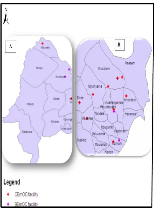
4.4 Status and Spatial Arrangement of EmOC Services in Kisarawe and Kinondoni Districts
Figure 4.1: Population and EmOCs distribution in Kisarawe District
Figure 4.2: Geographic distribution of EmOC services in Kinondoni District
5. CONCLUSION AND RECOMMENDATION
In this research study, complex array of decision criteria including environmental, technical, economic, and social issues related to life saving were analyzed by integrating Multi-criteria Decision Making (MCDM) with Geographic Information System (GIS). The developed framework serves as tool for future planning EMS in urban and rural areas of Tanzania and Africa in large. The framework helps to determine the optimal EMS facility locations by considering the appropriate strategies for facility deployment which is to maximize the EMS coverage; the number of facilities assigned to each demand point (facility quantity); and the distance up to which a facility should service a demand point (EMS quality).REFERENCES
[1]. Sachs, J.D. and McArthur, J.W. (2005). The Millenium Project: A plan for meeting the Millenium Development Goals. Lancet 365 , 347-353.
[2]. Gu, W., Wang, B., Wang, X. (2011). An Integrated Approach to Multi-Criteria-based Health Care Facility Location Planning. Retrieved October 18, 2012, from
http://www.springerlink.com/index/145275153M0362 01.pdf
[3]. Lwasa, S. (2007). Geospatial analysis and decision support for health services planning in Uganda. Geospatial Health , 2 (1), 29-40.
[4]. Stansfield, S.K., Walsh, J., Prata, N. and Evans, T. (2006). Information to improve Decision Making for Health. Disease Control Priorities in Developing Countries , 1017-1030.
[5]. Razzak, J.A. and Kellermann, A.L. (2002). Emergency medical care in developing countries: is it worthwhile? Bulletin of the World Health Organization , 80, 900-905.
[6]. Penoyar, T., Cohen, T., Kibatara, P., Magoda, A., Saguti, G., Noel, L., Groth, S., Mwakyusa, D.H. and Cherian, M. (2012). Emergency and surgery services of primary hospitals in the United Republic of Tanzania. Retrieved November 6, 2012, from Biomedical Journal: http://www.bmjopen.bmj.com
[7]. MoHSW. (2008). Health Sector Strategic Plan III. "Partnerships for Delivering the MDGs" July 2009-June 2015. Final Draft Version. Dar es Salaam: MoHSW.
[8]. Malczewski, J. (1999). GIS and Multi-Criteria Decision Analysis. New York: John Wiley & Sons Inc.
[9]. Roy, B. (1996). Multi-criteria methodology for decision aiding. Dordrecht: Kluwer Academic Publishers.
[10]. Śanchez-Lozano, J.M., Turuel-Solano, J., Soto-Elvira, P.L. and Garcia-Cascales, M.S. (2013). Geographical Information System (GIS) and Multi-Criteria Decision Making (MCDM) methods for the evaluation of solar farms locations: Case study in south-eastern Spain. Elsevier, 24, 544-556.
[11]. National Bureau of Statistics. (2013). Population and Housing Census: Tanzania Distribution by Administrative Areas. Dar es Salaam: United Republic of Tanzania.
[13]. WHO, UNFPA, UNICEF, AMDD. (2009).
Monitoring Emergency Obstetric Care. A Handbook. WHO Press, Geneva,151pp.
Author Profile
Dr. Chaula holds a Bachelor‟s of Science in Physics and Electronics of the University of Dar es Salaam, Dar es Salaam Tanzania, 1996, Masters of Science in Computer and Systems Sciences of the University of Stockholm, Stockholm Sweden, 2003 and PhD in Computer and Systems Sciences of Stockholm University, Stockholm Sweden, 2006. His major field of study is computer and Systems security.