• No results found

Glacier changes in the Karakoram region mapped by multimission satellite imagery

N/A
N/A
Protected

Academic year: 2020

Share "Glacier changes in the Karakoram region mapped by multimission satellite imagery"

Copied!
13
0
0

Loading.... (view fulltext now)

Full text

Figure

Figure 1. Overview map of the Karakoram. Surge-type glaciers are marked with red triangles
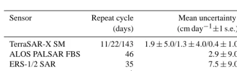
Table 1. Overview of sensors used for velocity mapping and their main characteristics
Table 3. New surge-type glaciers identified in this study. Surge-type features include (1) looped/folded medial moraines and surface foliation,(2) terminus advance, (3) terminus steepening and thickening, and (4) increased surface velocities (according to Copland et al., 2011).
Figure 4. Temporal course of advancing and retreating glaciers, aswell as glaciers in the active phase of a surge during various timeperiods
+4

References

Related documents