Chapter 1
Introduction to the Quaternary
of northern England
N. F. Glasser
From:
Huddart, D. & Glasser, N.F., (2002), Quaternary of Northern England, Geological Conservation Review Series, No. 25, Joint Nature Conservation Committee, Peterborough, 745 pages, illustrations, A4 hardback, ISBN 1 86107 490 5
Site selection guidelines
3
RATIONALE FOR SELECTION AND
CONSERVATION OF QUATERNARY
SITES IN NORTHERN ENGLAND
Northern England is a large geographical area, stretching from the Cheshire–Shropshire low-lands in the south to the Scottish Borders in the north. As such it contains a wide variety of dis-tinctive landscapes and much scenic diversity. This varied topography reflects the interplay of geological controls, geomorphological process-es and the effects of climatic change, most recently during the Quaternary Period. The present landscape, therefore, is the result of a long history of evolution that reflects the inter-action of geology, topography, climate, geomor-phological processes, and their changes through time. The effects of climatic changes are record-ed both in landforms and srecord-ediments, and in the records of flora and fauna and their change over time. Evidence for environmental change dur-ing the Quaternary Period, therefore, is wide-spread and diverse in its nature. It is clear that we need to understand the nature of these envi-ronmental changes if we are to have any success in predicting future changes in climate. It fol-lows that the sites containing the most impor-tant evidence for Quaternary climatic change must be preserved for future research and study.Selecting the sites for conservation that best reflect these changes is, however, a challenge to the conservationist. Decisions have to be made about the scientific value of individual sites, about the nature of the evidence present at each and about the suitability of individual sites for long-term conservation. Decisions also must reflect the holistic nature of the subject and are sometimes based on the contribution that a site makes to a suite of related sites, which imbues it with more importance than it has in isolation.
SITE SELECTION GUIDELINES
The former Nature Conservancy initiated the identification of the most important geological and geomorphological sites in Britain in 1949, before the Nature Conservancy Council (now the Countryside Council for Wales, English Nat-ure, Scottish Natural Heritage and Joint Nature Conservation Committee) began a systematic review of the key Earth science localities in 1977. The site selection phase of this review, known as the ‘Geological Conservation Review’ (GCR), was completed in 1990. The aim of the GCR was
to identify, and to help conserve, the geological and geomorphological sites of national and international importance in Britain. No other country has attempted such a systematic and comprehensive review of its Earth heritage resource. The majority of sites documented in this volume were selected for the GCR between 1977 and 1990, although, as a result of prepar-ing a text for publication a small number of addi-tional sites have been proposed for features not yet represented in the 1990 list, reflecting changes in interpretation and new scientific dis-coveries.
Site selection was determined on the basis of a number of guidelines. These guidelines aim to encapsulate the full range of scientific interests within the disciplines of geology and geomor-phology in Britain. Decisions concerning the sites that should be conserved were made on the basis of a number of criteria (Ellis et al., 1996). Two operational criteria were used by the GCR workers in site selection:
1. There should be a minimum of duplication of features of interest between sites;
2. It should be possible to conserve any pro-posed site in a practical sense.
All scientific factors being equal, sites that can-not be conserved, or which entirely or largely duplicate the interest of another, were excluded. Overall, a preference was given to the sites that are least vulnerable to potential threats, to those that are most accessible and to those sites where the interest is not duplicated by other sites.
Sites were selected within individual subject areas known as ‘GCR Blocks’. Each block covers a specific geological time period or event, or, in the case of Quaternary sites, a geographical area. Within individual blocks, preference was given to sites that:
1. Demonstrate an assemblage of geological fea-tures or scientific interests;
2. Show an extended, or relatively complete, record of the feature of interest. In the case of geomorphological sites this often equates to sites that contain features that have been least altered after formation. For Quaternary GCR Blocks, this relates to sites containing an extended fossil record, including pollen, insects and molluscs, which can be used to infer vegetation history or environmental change;
Introduction to the Quaternary of northern England
3. Have been studied in detail and which have a long history of research and re-interpretation; 4. Have potential for future study;
5. Have played a significant part in the develop-ment of the Earth sciences, including former reference sites, sites where particular British geological phenomena were first recognized, and sites that were the focus of studies that led to the development of new theories or concepts.
In order to ensure that GCR site status is con-fined to sites of national or international impor-tance, the number of sites selected was restrict-ed to a reasonable minimum. Only those that are necessary to characterize the block in ques-tion, that is, to demonstrate the current under-standing of the range of Earth science features in Britain for that block, were selected. These fac-tors are important in the justification of the scientific value of a GCR site if subsequently it is to be designated a Site of Special Scientific Interest. For example, the scientific case for con-serving a given site is stronger if it is the only one of its kind, or if it is demonstrably the best of a set of similar examples.
Some of the sites described in this volume are unique, in that they are either the only known representatives of particular parts of the geolog-ical record or they may be without counterparts in the rest of England or even internationally. Hightown, Formby Point, Chelford, Thornsgill Beck, Warren House Gill, Mosedale Beck and Wolf Crags, and Sewerby are good examples of such sites.
A second group of sites are those that are included because they are nationally or interna-tionally recognized as being classic examples of particular landforms or features that are referred to in standard textbooks. Examples of such sites include Roman Wall, Giggleswick Scar, Norber Erratics, Newtondale and Wasdale Screes.
Other sites are representative of important aspects of geomorphology, landscape evolution or environmental change in northern England during the Quaternary Period. Certain sites, therefore, were selected because they are the best-studied, the best-preserved and/or contain the most complete local representation of phe-nomena that otherwise are widespread. They are therefore important reference sites for the particular phenomena or area concerned. Examples are sites containing glacial deposits or landforms such as end or hummocky moraines,
meltwater channels, kames, kettleholes and eskers. Included in this category are sites such as Bradford Kames, Humbleton Hills and the Trows, Ludworth Intake, Newtondale and the Hole of Horcum, and Aqualate Mere. Other sites may represent either formally or informally rec-ognized reference sites for Quaternary stratigra-phy, such as Four Ashes, Chelford, Dimlington, Blelham Bog and Low Wray Bay.
Where there is a strong geographical compo-nent in the scientific interest, a series or ‘net-work’ of GCR sites was chosen to include differ-ent aspects of one general type of phenomenon that shows significant regional variation in char-acter, for example in relation to climate, geology or relief. Such networks may comprise unique, classic or representative sites. A prime example is the network of sites selected for the GCR to demonstrate the evolution of tors during the Quaternary Period in northern England (Table 1.1). This small network, comprising a total of eight sites, illustrates not only the lithological and morphological variety of these tors, but also their different pre-Quaternary and Quaternary history (for example, relationship to glacial events). Collectively, this network represents the minimum number of sites required to show this diversity in tor morphology and develop-ment history. There is also a minimum of dupli-cation of interest between individual sites, with each site representing a different aspect of tor evolution in northern England.
Another good example of the GCR network approach is those sites that illustrate the types and rates of vegetational change in the Quat-ernary Period following the climatic ameliora-tion at the end of the Late Devensian. The pat-tern and timing of the spread of trees and vege-tation at this time varied throughout the country. Clearly no single site can encapsulate such a complex and diverse aspect of Quaternary history. Examples of sites for which this site selection principle was particularly applicable include those sites that illustrate the nature of mountain periglacial landforms and sediments (Helvellyn, Skiddaw and Cross Fell), Late-glacial and Holocene vegetation change (Kildale Hall, Skipsea Bail Mere, Skipsea Withow, Fen Bogs, Gormire, Tadcaster, Willow Garth (Boyton), Featherbed Moss, Red Moss and Blea Tarn) and Holocene changes in sea level (Lytham, Hartlepool and Downholland Moss).
Some sites are included in the GCR because they demonstrate the nature of current debates
Structure of the volume
5 within Quaternary science. A good example of this is the network of sites that were selected to illustrate the nature of events during the Late Devensian deglaciation of the Irish Sea Basin. Sites such as Thurstaston, St Bees, Holme St Cuthbert and Annaside and Gutterby Banks on the western side of northern England were all selected for this reason. A related network of sites is that which provides information regard-ing events on the eastern side of northern England during the same time period (Warren House Gill, Speeton, Shippersea Bay (Easing-ton), Dimlington and Sandy Bay).
A final justification for the inclusion of sites in the GCR is the interpretation or interpretations, which are sometimes controversial, that have been placed upon them. Such sites may illus-trate the development of scientific thinking on the subject of landscape evolution and the debates concerning process and chronology that are characteristic of Quaternary science. It clear-ly is important that such sites are conserved for further study and to stimulate active scientific debate. A good example of this is the network of sites selected for the GCR that have been the subject of debate on the development of tors and associated weathering features. The descrip-tions and interpretadescrip-tions of sites such as the Bridestones, Blackstone Edge, Brimham Rocks, Burbage Brook, Great Almcliff Crag, the Stiper-stones, Wyns Tor, and Cheviot Tors have all been important in the interpretation of the age and
significance of tor landforms in Britain.
There are many outstanding questions not yet resolved regarding the Quaternary features of northern England but, as this volume is intend-ed to illustrate, this is a strength rather than a weakness of Quaternary science. Although new sites undoubtedly will become available for study, it is vital that the existing sites are main-tained for the application of new research tech-niques. The long-term research potential of many sites therefore is implicit in site selection. Equally, the educational importance of these sites should not be overlooked. Collectively, the site coverage provides a history of the evolution of the landscape of northern England as record-ed in its landforms and srecord-ediments.
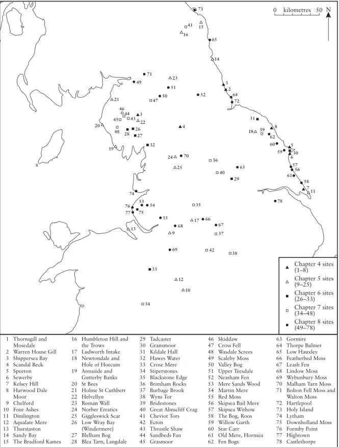
This volume is therefore a synthesis of descrip-tions of all of the sites in northern England that merit statutory conservation for their import-ance to Quaternary science (Figure 1.1). Mod-ern process studies of coastal and fluvial geo-morphology, karst and caves, and large-scale mass movements are each reviewed in separate thematic volumes of the GCR series (Gregory, 1997; Waltham et al., 1997; May and Hansom, in press).
STRUCTURE OF THE VOLUME
In the chapters that follow, the sites are arranged according to broad themes related to important Table 1.1 Quaternary of northern England: tor evolution network
Introduction to the Quaternary of northern England
Structure of the volume
7 time periods and events during the Quaternary history of northern England. Each of these chap-ters begins with an overview of events in north-ern England during that time period, highlight-ing the particular aspects of the Quaternary that are scientifically important. The individual site reports within these chapters are syntheses of the scientific documentation currently available, together with an interpretation of this informa-tion. Chapter 2 provides an introduction to the Quaternary Period, covering topics such as climatic change and the techniques used to establish this change. Chapters 3 and 4 provide details of the pre-Quaternary inheritance of northern England, including Tertiary landforms
and deposits, and the Early and Middle Quat-ernary development of the area, respectively. Chapter 5 deals with the Devensian glacial stage, the period providing most evidence of glacial conditions in northern England. Chapter 6 gives details of the very varied environments that arose from rapid climatic change at the end of the Devensian cold stage and Chapter 7 provides details of the periglacial inheritance from this period. The volume ends with details of the numerous sites that show adaption to the milder environmental conditions that have prevailed since the end of the Devensian glacial stage and their relationship to the anthropogenic influ-ences.